The MHB: geological setting
The Mesohellenic Basin: definition and overview
The Mesohellenic Basin (MHB), located in Northern Greece and Albania (Fig.1A and 1B), was formerly called “Albano-thessalian” by Bourcart [1925], before being named Mesohellenic Basin (MHB) by Brunn [1956] and Aubouin [1959]. It is called “Mesohellenic” as it develops in the middle part of the Hellenides. Compared to most other intermontane basins, the MHB is remarkable by its large dimensions (more than 300 km long with its Albanian part, half in Greece, 30 km wide and with a thick pile of sediments 4,5 km of vertical thickness). It has been said to be “molassic” as it is filled with detrital sediments (marls, shales, turbidites, conglomerates) unconformably overlying the deformed Mesozoic-Paleocene basement and some early Tertiary thrusts. However, its sedimentary fill is mostly syntectonic.
The basin mostly developed east of the main Tertiary tectonic boundary between external and internal zones of the Hellenides, known as the “Internal Zones Thrust” part of a very large thrust system located beneath the MHB (Fig. 1B and Fig. 2).
Figure 2. Location of the Mesohellenic basin (MHB).
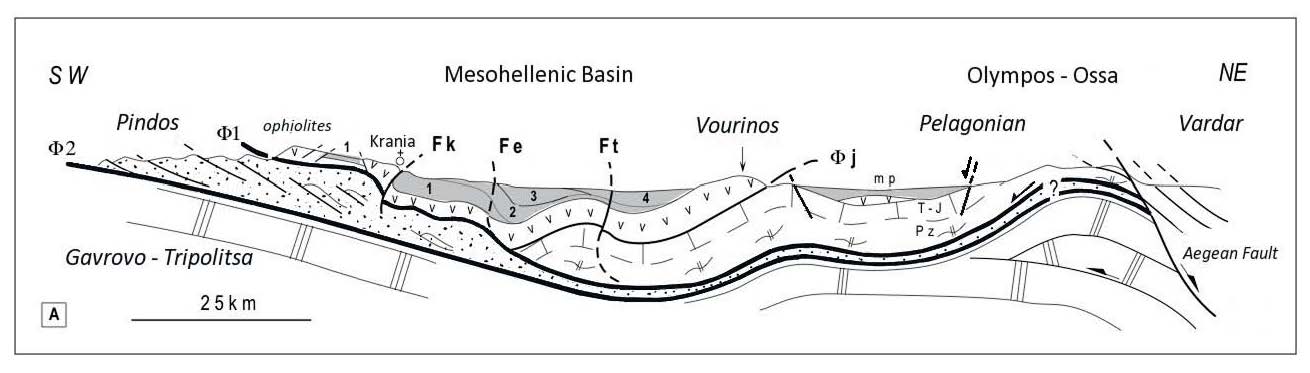
Cross-section showing the MHB as a piggyback basin above the main Tertiary thrusts responsible for the Olympos window (modified after Ferriere et al. [1998]). See Fig. 1 for location. 1 to 4: MHB Formations, same captions as in Fig. 1. Fe, Fk, and Ft: faulted-flexures of Eptachorion (Fe), Krania (Fk) and Theopetra-Theotokos (Ft). Φ1 and $Phi;2: main Tertiary thrusts j: Jurassic obduction. Vertical scale: maximum thickness of the MHB sediments on the cross-section: 4 km.
In this area, the internal zones are made up of the Pelagonian continental crust (Triassic to Jurassic metamorphic limestones and Paleozoic gneisses) partly overlapped by upper Jurassic ophiolites thrust again towards the west onto the Pindos units during the Tertiary events [Brunn, 1956 ; Aubouin, 1959] (Pl. I-A). Most of the MHB fill rests above these thick ophiolitic units obducted during the Jurassic.
The external zones consist of Pindos series, mainly of Pindos flysch nappes, just west of the Pelagonian zone below which the thin, continental or oceanic (?) Pindos crust was underthrusted to the east.
This basin is Cenozoic in age: it was infilled between the Upper Lutetian (ca 45 Ma) and the middle Miocene (ca 15 Ma), spanning over 25-30 Ma (Fig. 3). Deposition follows a major deformation episode of the internal zones in the lower-mid Eocene. Upper Lutetian-upper Eocene marine deposits unconformably rest above the basement of internal zones, while Oligocene sediments overlap unconformably both the external and internal zones and seal the “Internal zone thrust”.
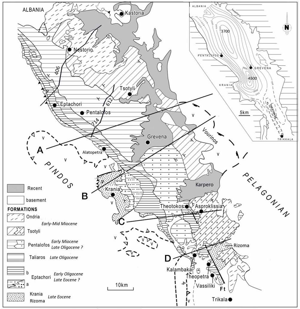
Figure 3. Map of the lithological Formations of the MHB.
Map of the lithological formations of the MHB. Modified after the Geological Maps of Greece at 1:500,000 [Bornovas and Rondogianni-Tsiambaou, 1983] and at 1:50,000 [cf. References], the synthetic map of Doutsos et al. [1994] and from our field study in the southern half of the MHB. Cross sections A to D see Fig. 4. Up right: depth contours of the basement below the basin from seismic data from Kontopoulos et al. [1999] completed in the south from field data (maximum thickness : 4500m near Grevena).
The MHB forms an elongated asymmetrical syncline, with steeper strata on its western flank (Fig. 4) . Another asymmetry raises as Miocene strata (Tsotyli Formation) are absent in the west and rest onto the basement in the east. (Figs. 3 and 4). Seismic profiles (Fig. 5) show a pinch out of deposits at depth [Kontopoulos et al., 1999; Zelilidis et al., 2002]. These data show that deposition is controlled by an overall eastward migration of depocentres and thus of subsidence (Figs. 3 and 4).
The width of the MHB decreases southward along strike. This is related to the basin squeezing to the south against the “Pelagonian Indentor”, which forms a spur of the basement of the internal zones to the SE of the basin (Fig.1A and Fig.3) [Ferriere et al., 2004].
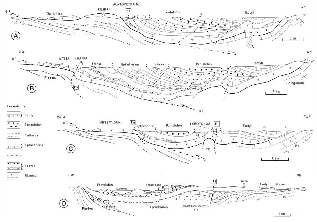
Figure 4. Cross-sections of the southern MHB.
Cross-sections of the southern MHB with no significant vertical exaggeration (modified after Ferriere et al. [2004], compiled from our field work, Geological Maps of Greece at 1: 50 000 [cf. References] and seismic profiles published by Kontopoulos et al. [1999] and Zelilidis et al, [2002]). See Fig. 3 for location. Abbreviations: TTS: Theopetra-Theotokos Structure; Fk, Fe, and Ft, faulted flexures of Krania, Eptachorion and Theopetra, respectively. Lithologies: see text. Krania Formation: a: conglomerates and olstoliths of the lower Krania sequence; b) turbiditic beds; c) thick unconformable turbiditic base of the upper Krania sequence. Eptachorion Fm: a) basal conglomeratic beds, (b) turbidites and marls. Tsotyli Fm: a) mainly conglomerates and sandstones; b) mainly sandstones and siltstones.
The southern part of the MHB is separated alongstrike by a horst, or faulted anticline called Theopetra-Theotokos Structure (“TTS”: Fig.3 and Fig.4), which splits the basin into two parallel parts, one to the west which is occupied by the Pentalofon Formation (lowermost Miocene), and the other, to the east, by the Tsotyli-Ondria Formation (lower Miocene p.p.) (Fig.1B and Fig.3 ).
To the NW, the MHB extends into Albania, where it is called "Albano-Thessalian basin". It might step over the major, transverse Scutari-Pec feature, which limits the Albanic and Dinaric chains (Fig.1A). In this article we only present the available data regarding to the greek part of the basin, and we mostly focus to its southern half.
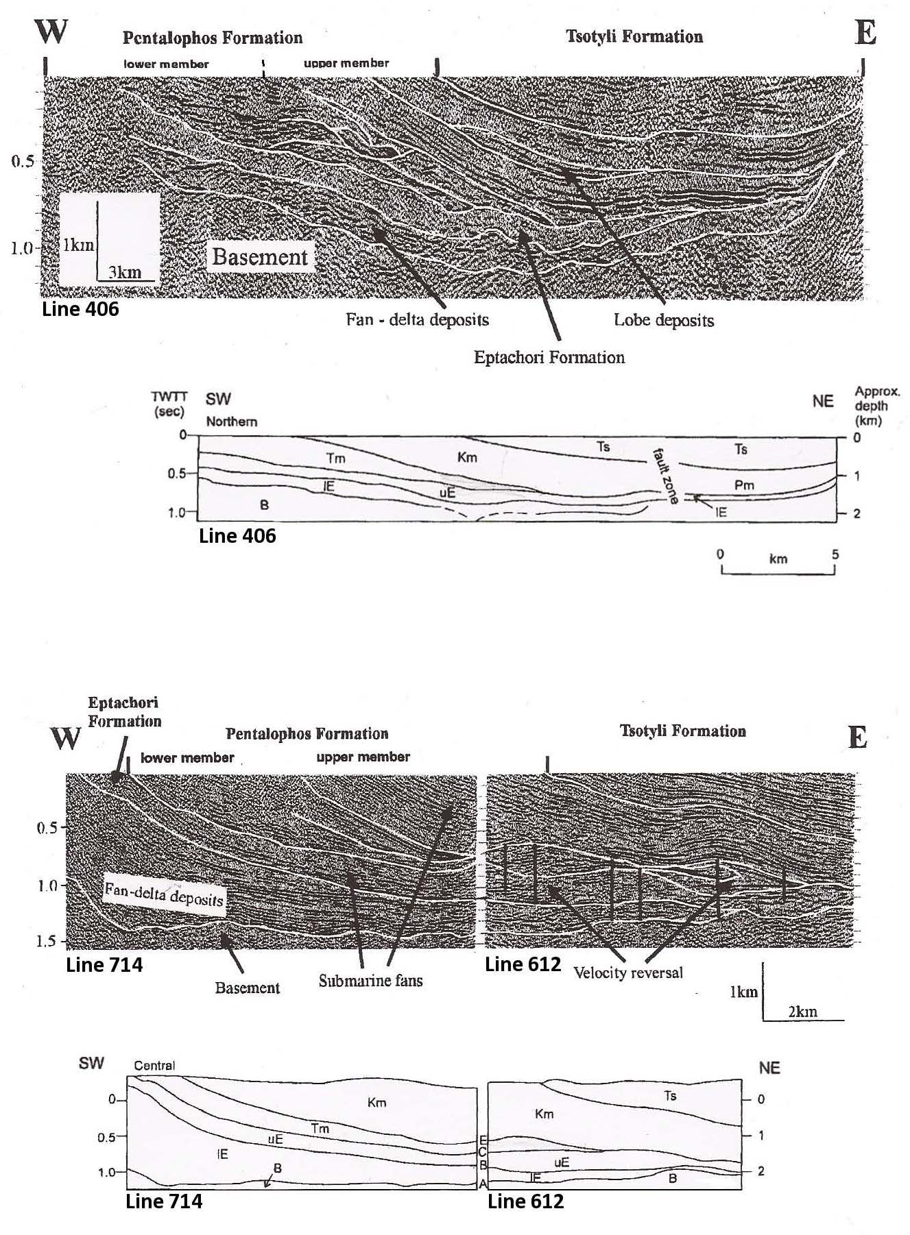
Figure 5. Seismic profiles in the northern MHB and their interpretation.
Seismic profiles in the northern MHB and their interpretation. After Kontopoulos et al. [1999], and Zelilidis et al. [2002]. Lines 406, 714 and 612: location see Fig. 3. Abbr: B: Basement; E: Eptachorion Fm (l: lower, u: upper); Km: Kalloni member; Tm: Tsarnos Fm; Ts: Tsotyli Fm.
Evolution of ideas about the MHB
The older attempt concerning the litho-chronostratigraphic framework of the MHB was published by Brunn [1956] and little changed by many workers since. The first detailed studies of the MHB were focused on mapping these lithological Formations [Brunn, 1956; 1969; Savoyat et al., 1969; 1971a; 1971b; 1972a; 1972b]. New maps concerning the MHB were published later [Mavridis et al., 1979; 1993; Koumantakis et al.,, 1980; Vidakis et al., 1998].
Other publications provided some refinements: i) biostratigraphic refinements based on Foraminifera [Soliman and Zygojiannis, 1980] and nanofossils [Zygojiannis and Muller, 1982]. New data on nanofossils were published by Kontopoulos et al., [1999] and Ferriere et al., [2004]; ii) source rock studies from heavy minerals [Zygojiannis and Sidiropoulos, 1981] or olistoliths [Papanikolaou et al., 1988; Wilson 1993]; iii) dynamics of depositional systems [Faugères 1977a; 1977b; Desprairies 1979 for the different Formations; Ori and Roveri, 1987 for the Meteora conglomerates].
New modern studies concerning the MHB were initiated since the ninety’s, essentially applied to i) sedimentological analyses and large-scale industrial seismic data [Zelilidis et al.,1996; 1997; Zelilidis and Kontopoulos, 1996; Kontopoulos et al., 1999; Zelilidis et al., 2002] and ii) tectonic and geodynamic data used to assess the first basin models [Doutsos et al., 1994; Ferrière et al., 1998; 2004; 2011; Vamvaka et al., 2006].
Following these various studies, the main stages of evolution of the MHB were established but divergent interpretations still exist about the geodynamic setting and also the interplay of eustacy regarding to the basin stratigraphy. Here below we first briefly present the lithological formations and tectonic deformations of the MHB, and then propose an attempt of reconstructing the basin evolution and discussing the main related mechanisms.
Figure Plate I. General view and facies of the lower part of the MHB fill
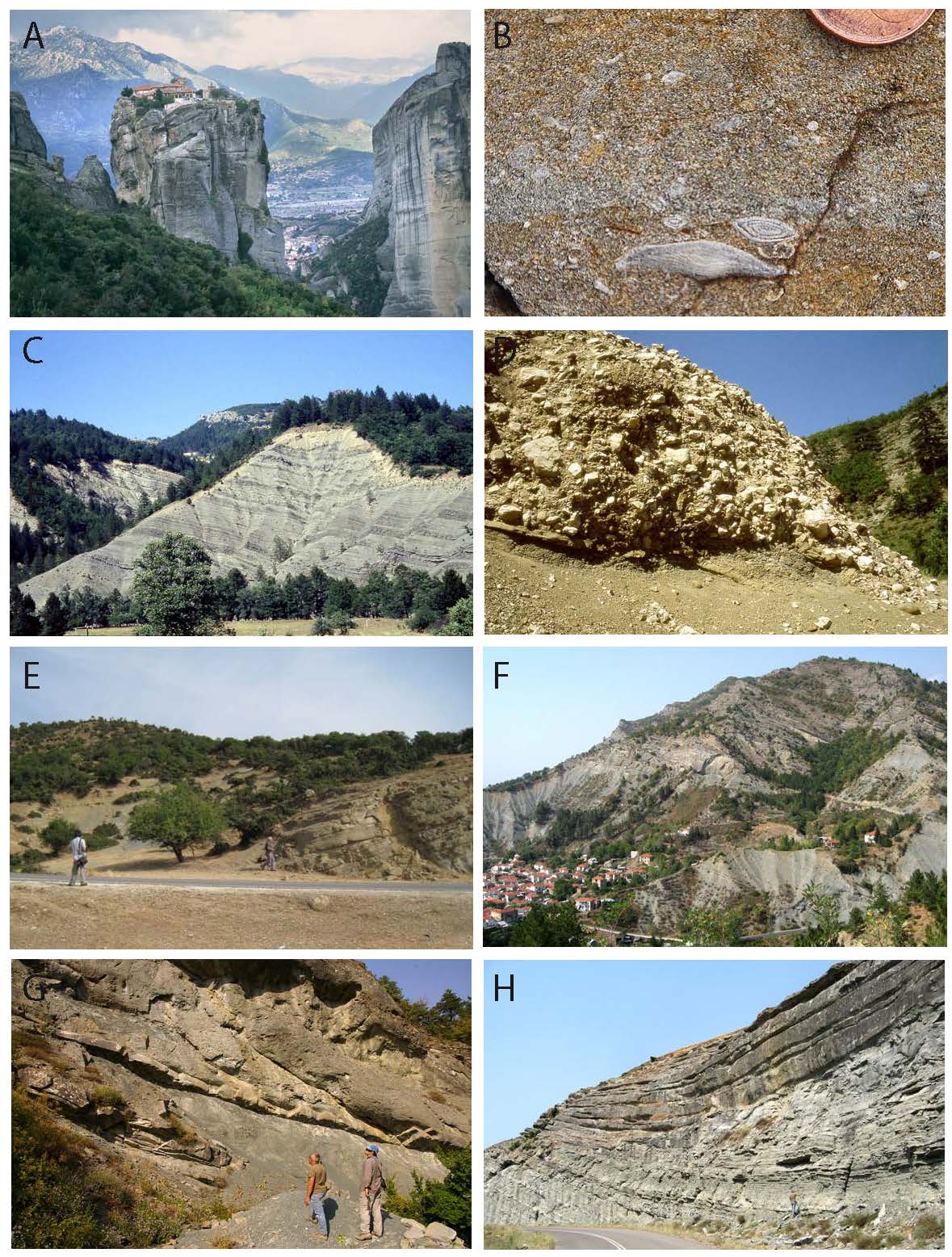
A) General view of the basin, looking westward. From the front to the background: lower Miocene (Meteora conglomerates), Oligocene sandstones (west of the Pinios river valley) resting unconformably over Jurassic limestones (Koziakas mountains) and, to horizon line, the Pindos flysch. B) Rizoma Formation: shelf limestones with large benthic foraminifera of Middle to Upper Eocene. Near Vassiliki, these limestones locally rest above the oldest conglomeratic deposits of the MHB. C) Lower Krania series (Late Eocene): ophiolite-rich, deep-sea sandy turbidites. Cretaceous limestone olistolites, up to tens of meters large, are present in the background. D) Krania series (Late Eocene): submarine channel fill with Cretacous limestone blocks incised within the upper Eocene turbidites of Lower Krania series. The sandstone bar to the right corresponds to the base of the Upper Krania series. E) Eptachorion Formation (Oligocene) : typical facies of Oligocene in vicinity (SE) of the Meteora : well-bedded sandstone (to the right) overlain by uppermost Eptachorion marls (top left: Tsotyli Fm). F) Transition from the thick marl succession of the upper part of Eptachorion Fm to the turbiditic sandstones of Tsarnos Fm close to Eptachorion village. G) Detail of the Eptachorion-Tsarnos transition of picture F. The marls are overlain by slumped turbidites and blocky slurry flows. H) Pentalofon Fm (Early Miocene): example of silty-sandy turbidites to the north of the MHB between Grevena and Pentalofon.