Geological data
From a geological point of view, three distinct sectors constitute the urban area of Catania (Fig. 2): the flat southern area, a portion of the Holocene coastal-alluvial plain of the Simeto river facing the Ionian Sea, characterised by a large sandy beach (the Plaia); the hilly south-western area, characterised by the marine deposits of the Lower-Middle Pleistocene cycle and the overlying flight of coastal-alluvial terraces, remnants of ancient coastal plains uplifted by tectonic processes; the central area, where the palaeo-valleys incised in the Pleistocene sedimentary substratum, characterised by several morphological terraces, have been filled by pre-historical and historical Etnean lava flows that, flowing from the NW to the SE, poured into the Ionian Sea.
According to Monaco et al. (2000) the old city, which lies on fragmentary Greek ruins and is bordered by the 16th century town walls (Fig. 2), developed on two morphologic terraces located at elevation of about 40 m a.s.l. (above sea level) (Montevergine) and 15 m a.s.l. (Ursino Castle), locally covered by the lateral fronts of the Fratelli Pii, Cifali and 1669 lava flows (Fig. 2). In fact, bore-holes carried out on the top of the Montevergine hill showed the occurrence of 20 m thick fluvial-coastal coarse polygenic sands that would have been deposited during the 60 ka sea level high-stand (Monaco et al., 2000). Moreover, bore-holes in the courtyard of the Ursino Castle (about 15 m a.s.l.) revealed the occurrence of fluvial-coastal silty sands and conglomerates deposited during the 40 ka sea level high-stand. Before the lava flow invasion, both these platforms should have constituted small terraces on the top of low sedimentary hills facing the coast, morphologically similar to the present cemetery hill (Fig. 2). These data confirm the palaeogeography deduced by the ante-1669 iconographic and cartographic documentation (see for example Fig. 4a, and discussion below) and allow us to imagine the geological setting of the region where the Greek colonists founded Katane: a flat hill (Montevergine) facing the sea towards the south-east, where the mouth of the short Amenano river offered a natural shelter to small boats. To the east, at the bottom of the hill, the large Larmisi lava flow extended as far as the sea (Fig. 2). On the southern slope, in a favorable orographic position overlooking the Catania Plain and the Plaia sandy beach, the theatre was built (Holm, 1925). Further southward, a lower morphologic terrace dominated the coast and represented a favorable site for defensive military structures (e.g. the Ursino Castle, built in the 13th century by the Swabian emperor Frederick the second).
The geological analysis, compared with ante-1669 cartography (see Fig. 4), shows that until the 17th century the old city mostly expanded on sedimentary terrain, as shown by the 16th century town walls whose southern layout was influenced by the outer-edges of morphological terraces. Only after the last eruption (1669 A.D.) and the last strong earthquake (1693), the city developed also above the pre-historical and historical lava flows. It’s worth noting that in the sector within the 16th century walls, the uppermost stratigraphic level consists of several metres thick ruins derived by the destruction due to the occurrence of the 1693 earthquake and by the following levelling of the main streets (Fig. 2).
In order to reconstruct the ancient harbour system of Catania, it is fundamental to fit the evolution of the coastline in the general context of the geological evolution of the area that mostly depends on Mt. Etna lava flow invasion, sedimentary processes and Holocene sea level change. The coastal morphology reflects the complex geological evolution as it is characterised by irregular basaltic cliffs in the northern sector, where distinct lavas flowed into the sea, and a linear sandy beach to the south, where the Catania alluvial plain extends. The 20 km long, north-south striking Plaia beach in the southern sector is the result of the coastal-alluvial deposition of sediments mostly transported by the Simeto river to the Ionian Sea. Before the lava invasions, it probably extended to the north, as suggested by bore-hole data and testified by the small sandy beach in the Ognina bay (Fig. 2). The northern sector is characterised by two basaltic promontories, corresponding to the pre-historical Larmisi and Ognina lava flows, showing up to 15 m high sea cliffs deriving from processes of retreat of the coastal profiles due to the continuous sea erosion. To the south, a third lower basaltic promontory is formed by the 1669 lava flow, at present completely covered by the docks of the Catania port. Bore-hole data (Monaco et al., 2000) and historical documents (Fig. 4) suggest an up to 2 km seaward shifting of the coastline since the pre-historical times, due to the flowing into the sea of the Larmisi, Ognina and 1669 lavas.
The Larmisi lava flow (Sciuto Patti, 1872) is the oldest and the largest in the urban area of Catania and extends from the north-western outskirts to the sea, where it forms a 2 km long and 10-15 m high cliff (the Larmisi cliff). The age of this lavas, above which most of the modern city has been built, is debated: Sciuto Patti (1872) subdivided it in two different flows, a southern one (the Larmisi lava) of prehistoric age, and a northern one (the Carvana lava) referred to the 122 B.C. eruption. This latter is attributed to the 252 A.D. eruption by Tanguy (1980), on the basis of archeomagnetic analysis. Moreover, following Gemmellaro (1858), we think that no lava flow reached Catania during the 122 B.C. event, whose historic descriptions seems rather referable to a summit explosion or a destructive earthquake (see also Mercalli, 1883). Other authors referred the whole lava flow to the 252 A.D. eruption (AA.VV., 1979; Romano and Sturiale, 1981; 1982; Lo Giudice and Novelli, 1998). In our opinion the Carvana and Larmisi lavas are the product of a single eruptive event that gave rise to the lava flow here named “Larmisi” in prehistoric times. As a matter of fact, a terminus ante quem is represented by the archaeological remnants of the old Bronze age (2000-1400 B.C.) which have been found in lava tunnels of the northern portion of this lava flow (e.g. Grotta Petralia; Grotta di Novalucello I, Privitera, 1998; Centro Speleologico Etneo, 1999). Considering the evident incongruence, it has been recently attributed to pre-protohistorical times (~4500 B.C.) on the basis of morphologic data (Monaco et al., 2000) and to protohistorical times (~2500 B.C.) by absolute age determination (Tanguy et al. 2007).
The Ognina lava flow is well exposed in the 1.5 km long and 5-10 m high cliff between the Ognina and the Guardia bays and has been referred to pre-historical times by Sciuto Patti (1872). Successively, several authors (Sartorius Von Waltershausen, 1880; AA.VV., 1979; Romano and Sturiale, 1981; 1982; Chester et al., 1985) attributed this lava flow the 426 B.C. eruption as they thought that it would have been produced by one of the three eruptions that, according to literary sources, reached the Catania area during the Greek colonization (693 B.C., 476 B.C. and 426 B.C.; Thucydides VI, 50-51, 72, 74, 88, 94). This attribution can be confuted if we critically revise the literary sources: in fact, only the 476 B.C. lava flow surely reached the sea (see Pindar, 1st Pithic Ode; Thucydides, book III, 116, and relative discussion in Chevallier, 1924; Tanguy, 1980; 1981; Tanguy and Kieffer, 1993; Tanguy and Patanè, 1996), whereas the 693 B.C. and 426 B.C. lava flows have not clearly been still located. Moreover, the absolute age (about 2000 B.C.) recently determined by Tanguy et al. (2007) supports the primary age attribution of Sciuto Patti (1872). This suggests that the coastal morphology at the time of the Greek colonization should have been very similar to the present.
The Ognina lava flow, together with the Rotolo lava flow, almost entirely filled a large bay occurring north of the Larmisi cliff, between Guardia and Ognina (Fig. 2). The Rotolo lava flow (Sciuto Patti, 1872) has been generally attributed to the 1381 eruption (Recupero, 1815; Gemmellaro, 1858; Sartorius Von Waltershausen, 1880; Sciuto Patti, 1872) on the basis of a manuscript of Simone da Lentini registered in the archives of the Catania Cathedral. This interpretation has been successively confirmed (AA.VV., 1979; Romano and Sturiale, 1981; 1982; Chester et al., 1985), even though recent archaeomagnetic analyses suggest an age attribution to the 12th century (Tanguy, 1980; 1981; Tanguy et al. 2007). Despite the Rotolo lava flow is at the present almost completely covered by modern buildings of the northern quarters of Catania, its boundary can be precisely drowned from the 1845 Sartorius Von Waltershausen map and from the 1929 Istituto Geografico Militare (scale 1:25,000) topographic map. In order to reconstruct the ancient coastal morphology, it’s useful to outline that during the 1381 eruptive event (started on 6 August at an altitude of 350 m a.s.l.) two distinct lava fronts reached the sea, partially filling the small bays of Ognina and Guardia (Recupero, 1815).
To the south, the 1669 lava flow forms a basaltic promontory (Fig. 2) completely covered since the beginning of the last century by the building of the western wharves of the Catania harbour. According to historic chronicles (Tedeschi Paternò, 1669), the eruption started on 11 March in the Nicolosi area, at an altitude of 900 m a.s.l., and gave rise to three main lava flows, one of which on 12 April reached the western fortifications of Catania that deviated the lava flow to the south where, surrounded the Ursino Castle on 14 April (Fig. 1b), it reached the beach below on 23 April, flowing into the sea for 500 m with a 1.5 km large front. It gave rise to a small bay (Fig. 4d-e), initially used as natural harbour to throw in dry the boats, successively filled by coastal fluvial sediments to form the ancient “Spiaggia della Marina” (Fig. 3b) and finally absorbed in the urban transformations.
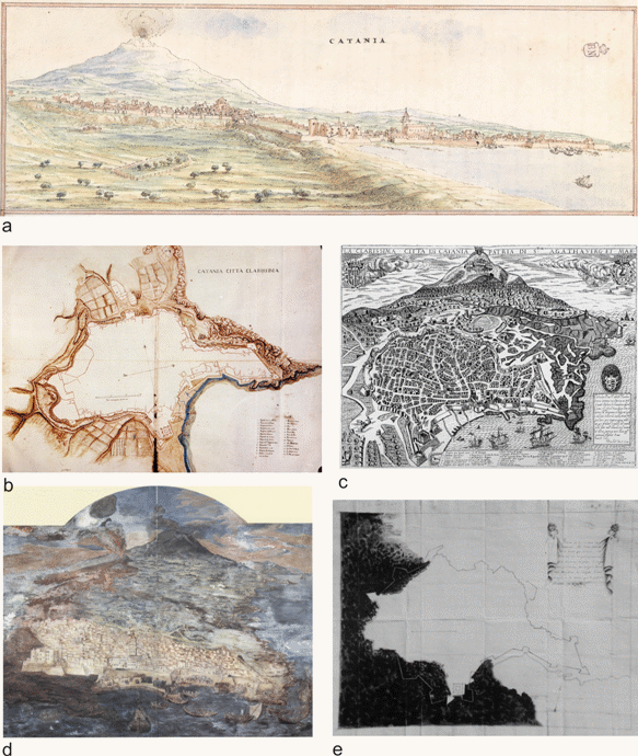
Figure 4. Ante-1669 cartography
a) Catania and Mt. Etna, panoramic view from the south in the drawing of T. Spannocchi (1578; from Giuffré, 1981); note the Ursino Castle along the seaside and the large sandy dune belt south of the castle. b) Catania in the map of F. Negro (about 1637; from Aricò, 1992); to the right, the western boundary of the Larmisi lava flow is evident. c) Bird’s-eye-view of Catania and Mt. Etna in the copper engraving of N. Van Aelst (Rome, 1592); note the location of the pier nearby the fortification gate “del Porticello”. d) Fresco of G. Platania in the Catania cathedral; e) The 1669 lava flow and the 16th century fortifications in the drawing of don Carlos de Grunenbergh (1673, from Boscarino, 1976).
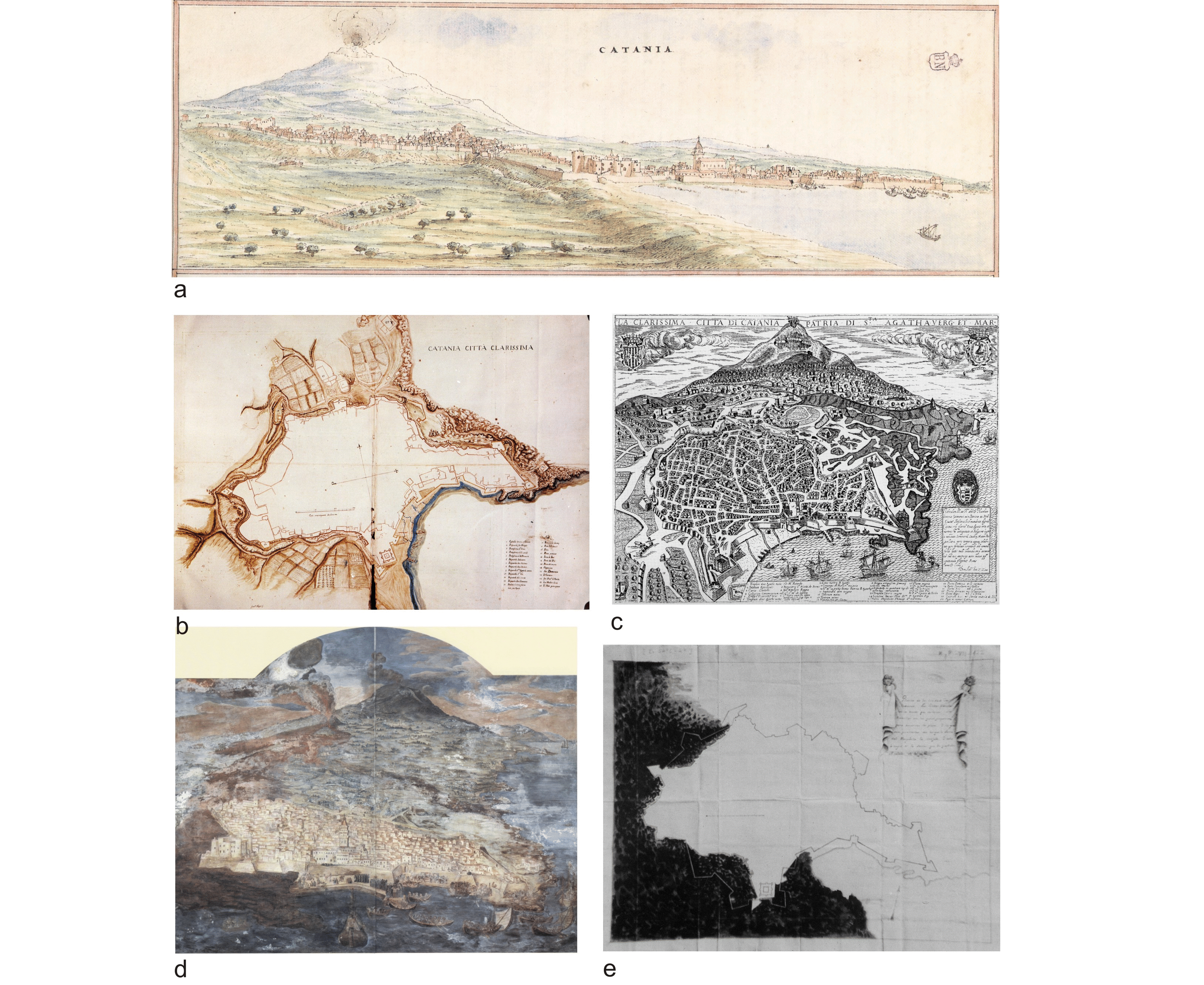
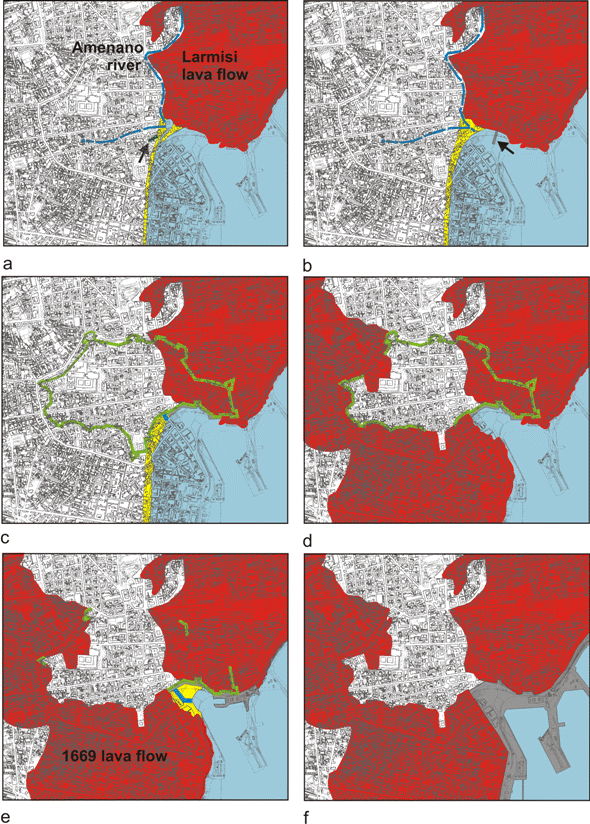
Figure 5. Harbour reconstructions
Reconstruction of the geological and anthropogenic modifications of the coastline in the harbour area of Catania; in yellow the beach and spit deposits, in red the lava flows, in blue the Amenano river and related canals, in green the 16th century fortifications, in grey the maritime works. a) Greek Archaic period (hypothesis); arrow shows the archaeological remains of Via Zappalà Gemelli. b) Roman period (hypothesis); arrow shows the possible location of the pier in opus pilarum. c) In 1637 A.D. (from the map of F. Negro). d) In 1669 A.D. (from the maps of don Carlos de Grunenbergh and Istituto Geografico Militare). e) In 1832 A.D. (from the Map of Catania of S. Ittar); f) Present.
Due to the lava flow invasions of the ancient drainage system, several changes occurred in the hydrographic network crossing the Catania urban area. A few pond and lacustrine environments developed and disappeared in the pre-historical and historical times, some of which are testified by the present toponymy (e.g. Cifali, Via Lago di Nicito). Moreover, considering that Etnean lavas represent a good aquifer for their high permeability and for the presence of an impermeable substratum represented by the Pleistocene clays, a complex groundwater system has developed. However, groundwater natural discharge often occurs at the contact between lavas and clays at several springs both in the town (Leucatia, Cifali, in the past Piazza S. Maria di Gesù) and along the coastline (in the small Ognina and San Giovanni Li Cuti ports). In the southern coastal stretch, covered by the 1669 lava flow, springs are clearly shown by the ante-1669 iconographic and cartographic documentation (Fig. 4). The great availability of spring water has certainly played a primary role both in the choice of the location of the colony in Greek Archaic age, and in the location of the thermal bath system in Roman age (Terme dell’Indirizzo, Terme della Rotonda, Terme Achilleane, Fig. 1c and 6).
Figure 6. Map of canal system

Map of the canal system explored by the Centro Speleologico Etneo in the Piazza Duomo area (by R. Bonaccorso, in Bonaccorso and Lo Giudice, 2002).
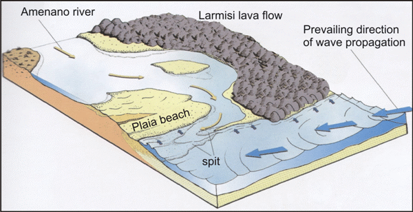
An important fresh water spring fed the Amenano river (Fig. 5a) that presently flows as a canal below the surface in Piazza Duomo (it is visible in the homonymous fountain located in the south-western corner of the square, Figs. 1d, 2 and 6) as far as the harbour area, only outcropping at the Villa Pacini. The origin of this small river has been always debated: it probably represents the emergence of a system of canals, partially of Roman age and rearranged during the 18th century (Bonaccorso and Lo Giudice, 2002; Fig. 6), that concentrate in the Piazza Duomo all the waters that probably bogged the more depressed sectors of the town (see discussion below about the possible Roman age of the land reclamation works). In particular, a canal along the Via Garibaldi suggests a western provenance of the Amenano river, at the bottom of the southern slope of the Montevergine hill (see also Sciuto Patti, 1872), whereas a canal along the Via Merletta suggests a northern provenance, along the present Via Etnea (see also Ferrara, 1829; Holm, 1925; Lo Giudice and Novelli, 1998), between the eastern slope of the Montevergine hill and the western front of the Larmisi lava flow, whose boundary is clearly reported in the map drawn by Negro in 1637 (Fig. 4b). Probably, when the Greeks founded Katane both small rivers existed, whose springs were fed by a large hydrogeologic basin located north-west of the town in the Etnean basalts covering the impermeable sedimentary substratum, and flowed together in the Piazza Duomo area (Fig. 5a). The mouth was located between the basaltic Larmisi promontory and the northern end of the Plaia beach.
Figure 7. Palaeogeography of the Piazza Duomo area
Hypothetic reconstruction of the palaeogeography of the Piazza Duomo area in Catania during the Greek Archaic period (from Longhitano, 2000, modified).
Because of modern levelling and urbanization of the Piazza Duomo area (see Fig. 1e), the present road surface, located at an elevation of 6 m above sea level, do not allow to recognize the ancient functional levels documented by the archaeological stratigraphy (Landolina, 1870; Tomasello, 1979; Dato, 1983). However, taking into account the tectonic uplift rates of the Etnean coastal area during the Holocene (2-3 mm/yr, Firth et al., 1996) and the sea level rise rates in the last 5000 years (about 1 mm/yr, Lambeck et al., 2004; Monaco et al., 2004), the field surface of the Piazza Duomo area, presently located by geophysical surveys at about 5 m below the road surface (Imposa et al., 2002; see also the floor elevation of the Terme Achilleane, Fig. 1 c), should have been located below the sea level (b.s.l.) at the time of the Greek colonization (about 2500 years ago):
Present field surface: 1 m a.s.l.
Tectonic uplift rate: 2 mm/yr
2 mm x 2500 years = 5 m
5 m – 1 m (present field surface) = 4 m
2500 years ago the field surface should have been located at - 4 m b.s.l.
But we must consider also the sea level rise in the last 2500 years (2 m)
Field surface elevation of Piazza Duomo area 2500 years ago = - 4 m + 2 m = - 2 m b.s.l.
Moreover, on the basis of geomorphologic considerations and bore-hole data, we can infer that in this area the Amenano river formed at its mouth a small coastal lagoon sheltered to the east by the basaltic Larmisi promontory and bounded towards the sea by a sandy spit (Fig. 7). This typically occurs at river mouths in coastal-alluvial plains flanked by rocky headlands because of the interplay between sea currents and sediment transport. As a matter of fact, recent bore-hole data suggest that the southern sector of Piazza Duomo (Palazzo dei Chierici; C. Zocco, personal communication) is characterized by a marine sedimentary succession, that can be interpreted as a coastal spit deposit, overlain by an alluvial interval. Conversely, west of Piazza Duomo (Via Vittorio Emanuele) probable lacustrine deposits occur under the road surface. Due to natural changes (tectonic uplift, alluvial-coastal deposition) and to numerous urbanistic arrangements occurred since the Roman colonization, the lagoon disappeared (see below).