The aim of the field trip is to present the main lithologic-metamorphic units exposed in Naxos and illustrate the nature of their mutual contacts. The structural, metamorphic, magmatic and sedimentary record of Naxos will be put in the context of the Aegean geodynamics and more generally in the scope of the thermal-mechanical evolution of a crustal accretionary wedge in a zone of lithospheric plate convergence. Issues stemming out of this field trip are summarized below.
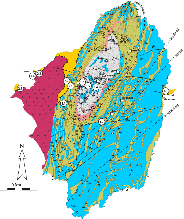
The island of Naxos displays a complex structure with polyphased folding of the marble and schist sequence, doming of the migmatites, localized deformation in mylonitic and cataclastic zones and a dense network of brittle faults. The exact chronology of these structures still needs to be established. The driving force responsible for the development of each of these structures is also controversial. Does magma buoyancy play a role in the development of the migmatite dome? What are the relative roles of tectonic forces related to plate tectonics and the gravity forces associated with lateral variations of crustal thickness? At last, the significance of each of these structures in terms of the tectonic record from crustal thickening to thinning remains to be established.
The structural section of Naxos exposes, as stated above, three tectonic-metamorphic units with contrasting metamorphic grade. The exact chronology of these metamorphic assemblages is only partially determined and the significance of the metamorphic gradients and offsets need to be addressed. What is the age and significance of the metamorphic assemblage of the marbles and schists of the upper unit? What is the significance of the relic blue schists assemblages preserved at the southern tip of the island? Does it imply that all rocks structurally beneath the blueschists were affected by a similar metamorphic grade or even higher? What is the significance of the metamorphic gradient from the greenschsits to the amphibolite facies rocks? Does it solely represent a contact metamorphism associated with upwelling of the migmatites or does it have a structural record? What are the causes of the transition from a low to a high geothermal gradient responsible for the genesis of blueschist and amphibolite facies rocks respectively?
The granodiorite pluton exposed on the west coast of Naxos is intrusive in the marble and schists of the middle unit to the south of the island and juxtaposed to sedimentary rocks along a cataclastic detachment toward its northern tip. More detailed investigation shows that the granodiorite is itself crosscut by several cataclastic zones and high-angle faults. What is the relative chronology of granodiorite emplacement and MCC development? What is the role of the detachment on pluton emplacement and conversely, what is the role of pluton emplacement on detachment development?
Fluid circulations are major vectors of matter and heat transfer and thus play an important role during the thermal evolution of crustal accretionary wedges. Recent investigations on the fluid record of MCC indicate that meteoric fluids potentially penetrate the crust down to the root decollement of detachment faults that correspond to the brittle/ductile transition (Morrison and Anderson 1998; Famin 2004; Famin and Nakashima 2004; Mulch, Teyssier et al. 2004). Rocks from Naxos display various traces of fluid circulation encompassing calcite and quartz vein networks, zones of hydrothermal alteration, zones of pervasive silicification. The characteristics of the fluids responsible for these features are only described in places. What are the nature and source of the fluids circulating during the tectonic-metamorphic evolution of Naxos rocks? Under which conditions were these fluids trapped? What controls the geometry of the various fluid reservoirs and in particular what is the role of detachments in draining fluids? What are the impact of fluid circulations in terms of mass and heat transfer?
One of the singularities of Naxos is to expose sedimentary rocks with deposition age similar to the age of metamorphic assemblages contained in exhumed metamorphic rocks. Although the exact timing and condition of deposition are under investigation, this sedimentary record allows reconstructing the evolution of surface topography from subsidence under marine conditions to uplift reaching aerial conditions during the development of the Naxos MCC. What is the role of erosion and lateral mass transfer in exhuming metamorphic rocks? What controls the changes in surface elevation during MCC development?

8h30-9h00: Naxos (Hora) - Kato Saggri
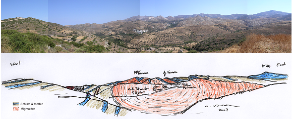
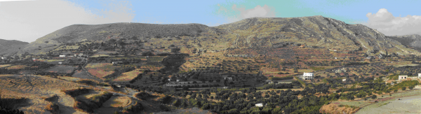
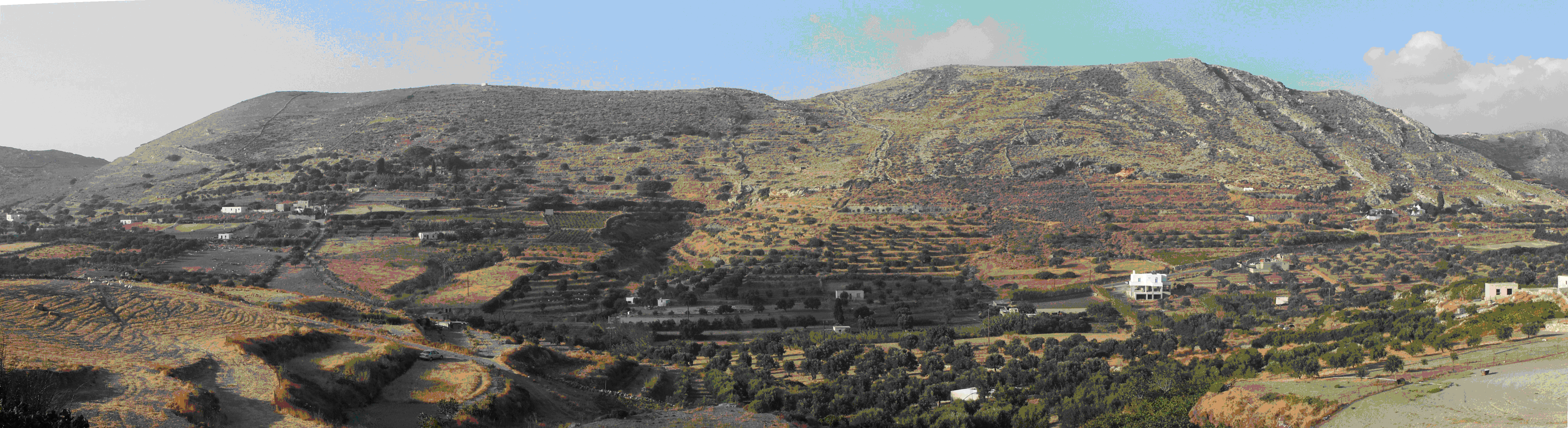
Stop 1: Panorama (Figure 9)
(Vanderhaeghe O.)
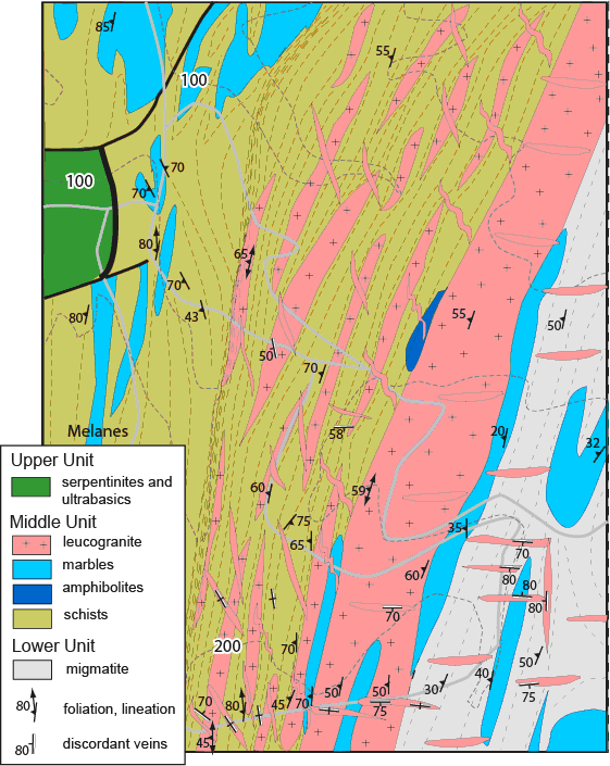
This northward panoramic view displays the principal metamorphic and magmatic rocks exposed in Naxos below the detachment system. These rocks are subdivided in:
- A lower unit composed by migmatites in the core of an elliptical shape structural dome
- A middle unit comprising alternating marbles and schists with minor calc-silicates, amphibolites and ultra-mafics.
- An upper unit formed by low-grade metamorphic rocks and coarse detritic sedimentary rocks
The contact between the lower and middle units is delineated by a crescent-shape leucogneiss decollement. The migmatite dome is characterized by second order subdomes with a complex geometry that will be better embraced later in the field trip (Day 1, Stop 4). The marble and schist sequence is affected by overturned isoclinal folds with axes dominantly parallel to the NE-SW trending mineral lineation. Marble layers forming cliffs owing to their resistance to erosion beautifully delineate these various structures. A sharp fluvial erosional surface (so-called Traghea plain by Hejl) affects the South of the dome and will be also encountered northward (Day 2, Stop 1).
9h30-10h00:Kato Saggri- Filoti
(Vanderhaeghe O.)
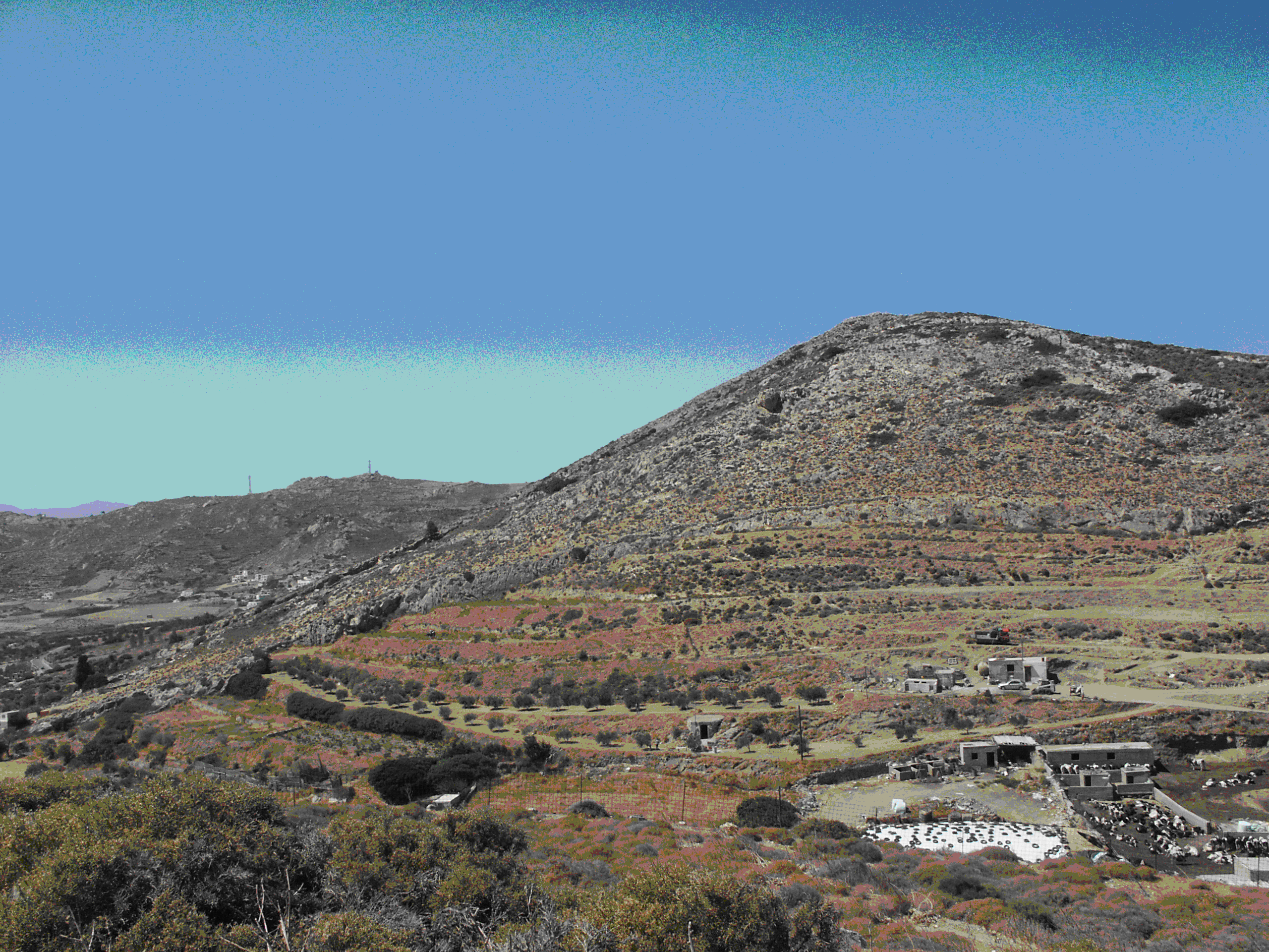
This northward panoramic view over the town of Filoti allows better catching the polyphased deformation of the marble and schist sequence and the structural relationship between these folds and the migmatite dome visible in the background, to the west of the panoramic view.
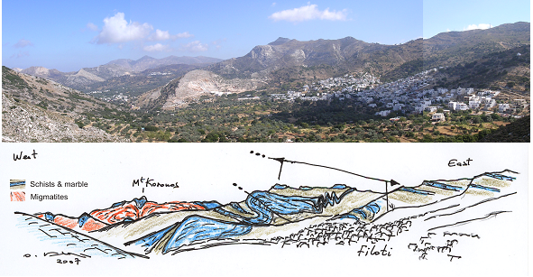

The transposition foliation marked by marble and schists alternations is associated with isoclinal centimetric to decametric folds. Some of these fold hinges are exposed to the east of the panorama. The transposition foliation is affected by hectometric recumbent folds with an apparent west vergence as illustrated by the large recumbent antiform/synform successions exposed to the north of Filoti. These folds are actually sheath folds with an axis parallel to the NW-SE mineral and stretching lineation as observed at outcrop scale and reconstructed at map scale. To the west of the Panorama, the transposition foliation dips to the east whereas to the east it dips to the west. This change in foliation dip marks the hinge of an open upright synform with an N-S axial trace.
10h30-11h00: Filoti-Moutsouna
(Hibsch C., Vanderhaeghe O.)
The outcrops along the shore near the port of Moutsouna displays a fault contact between green-schist facies metamorphic rocks of the middle unit and a serpentinized peridotite belonging to the upper non-metamorphic unit. The peridotites are affected by EW normal faults sealed by sedimentary deposits (Figure 13). They represent part of an ophiolitic sequence. The molassic sediment contains pebbles of the serpentinized peridotites but also from sedimentary rocks unknown in Naxos. Nummulites in some pebbles indicate shallow marine conditions during the Palaeogene coeval with the transition from thickening to thinning of the crustal accretionary wedge. These pebbles are now reworked in poorly dated Neogene sediments To the North of the peninsula Burdigalian marine turbidites are locally preserved (Figure 13). To the East in the closest islands, fresh water carbonates and travertines are widely exposed and supposed to be Serravalian to Early Tortonian in age. They provide a record of the progressive exhumation of the marbles exposed to karstification under relatively smooth surrounding landscape conditions (to be compared to the morphology of the western part of the island to be described the following day). The Burdigalian and Serravalian sediments are uncomformably overlain by two fluvial detrital sequences (green and then red continental molasse) marking a drastic geomorphic change from shallow marine to continental conditions (Figure 12). Both contain marble and schists from the underlying tectono-metamorphic units and record the progressive exhumation of the metamorphic rocks as well as surface uplift. These units are affected by variously striking normal faults which may have affected the detachment (Figure 1) 13).

Figure 13. Moutsouna 3D
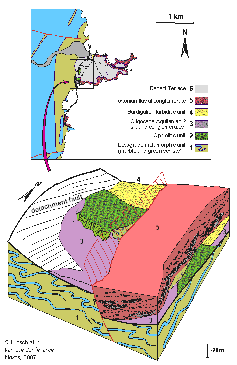
Geological map of Moutsouna peninsula and 3D view of the detachment and associated structures
12h30-13h00: Lunch break (Sandwiches)
13h00-13h30: Moutsouna-Kinidaros
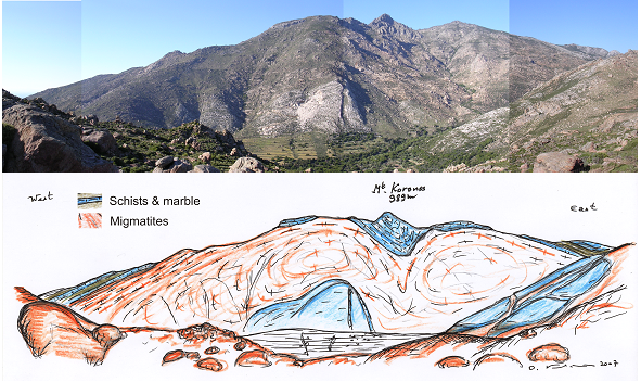
Stop 4: Panorama Dome and subdomes (Figure 14)
(Vanderhaeghe O., Kruckenberg S.)
This stop, to the east of the town of Kinidaros, at the intersection between the paved road and a small trail leading to Garimou springs, displays a panoramic view of the core of the migmatite dome culminating with Mt Koronos. The internal structure of the migmatite dome is delineated by large marble enclaves forming the slopes of Mt Koronos which is itself located in the core of a marble synform.
14h00-14h15: Kinidaros-Bolibas
(Vanderhaeghe O., Kruckenberg S.)
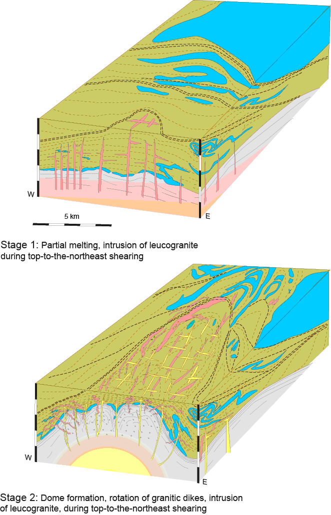
This section along a roadcut going west from the pass to the west of Kinidaros, exposes the variety of lithologic types in the migmatite dome and illustrates the relationships between structures acquired under solid and magmatic state. Marbles and associated schists and amphibolites are affected by polyphased folding with axes parallel to the stretching lineation. All these lithologies are present as enclaves in the migmatites. Migmatites encompass metatexites and diatexites dominantly derived from the schists but also potentially from the amphibolites. The synmigmatitic foliation of the migmatites, underlined by leucosome/melanosome alternations in metatexites and by the alignment of enclaves in diatexites, is roughly concordant to lithologic contacts. The attitude of this synmigmatitic foliation is at first order also concordant to the dome boundary but it delineates second order structures within the dome designated as subdomes.
These features indicate that partial melting leading to the genesis of the migmatites postdates deposition of the sedimentary sequence and that formation of the dome and subdomes was achieved while migmatites were under a magmatic state. The complex pattern of subdomes suggest that flow of the migmatites result from a combination of buoyancy driven upwelling of the magma and regional top-to-the-north shearing associated with E-W shortening.

15h30-15h45: Bolibas-Kouchounohori
Stop 6: W-detachment/decollement (Figure 16)
(Vanderhaeghe O., Siebenaller L.)
This roadcut shows a continuous section across the dome boundary and the contact between the middle and upper units. To the east of the section, schists with minor amphibolites and calcsilicates contain granitic veins transposed to various degrees; totally transposed veins forming leucogneiss layers from centimeter up to several tens of meters thick. Going west, this unit is affected by increasing deformation reaching ultramylonitic fabric characterized by extreme grain-size reduction. The mylonitic zone is associated with quartz enrichment suggesting a significant input of silica associated with fluid circulation. The western side of the mylonite is associated with greenschist facies retrogression and is characterized by a dense network of veins. Low-grade marbles and schists are found structurally above this mylonite.
Figure 16. Western mylonitic contact
Geological map of western mylonitic contact between Middle and Upper units (Kouhounohori)
17h30 : Kouchounohori-Hora
8h30-9h00: Naxos (Hora)-Melanes
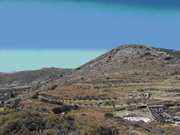
Stop 1: Panorama Melanes (Figure 18)
(Hibsch C.)
To the east of the panoramic view from Melanes (Figure 17) the contact between the non-metamorphic upper unit and the middle unit is exposed. The western side displays the faulted contact between the granodiorite and the upper unit. We will reconstruct this cross-section starting from the site of the panoramic view to the outcropping granodiorite, more or less following cross-section C-D from Fig. 18. Of particular interest is the presence of a marble and schists landslide which overlays the Paleogene and Neogene sediments.
We propose that this huge kilometric-scale landslide occurred as a consequence of uplift along the tectonic contact on the western side of the dome. Marbles and schists forming the landslide were previously exposed under aerial conditions before sliding as revealed by tilted paleokarst evidences at its front (Figure 19). Collapse of the landslide is associated with olistostromic deposits (Figure 1) 20). This uplift is also marked by an increase in detrital deposits and the lack of travertine deposits which in contrast occur further west on Paros Island away from the more active tectonic border. This event is considered to be of Mid Miocene age (Serravalian-Tortonian), almost synchronous with the granodiorite magmatic emplacement along the detachment. The metamorphic rocks and the granodiorite are cross-cut by E-W striking faults (Figure 18).
Exhumation of the metamorphic rocks and transtensional faulting were more or less fossilized as revealed by the position of the Traghea fluvial erosional surface (Day 1 stop 1 and cross-section A-B Fig. 18). Remnants of this surface and overlying conglomerates (Figure 1) 21; Fig. 22) are preserved in this panorama but were northward tilted here due to the continuation of extension associated with the continuing unroofing of the granodiorite (Figure 18). At last, during this exhumation, the granodiorite has been also bordered by high-angle faults.
Figure 17. Panorama
Panorama of the sedimentary unit and above-lying landslide and tilted erosional surface viewed North from Melanes
Figure 18. Galanado-Melanes
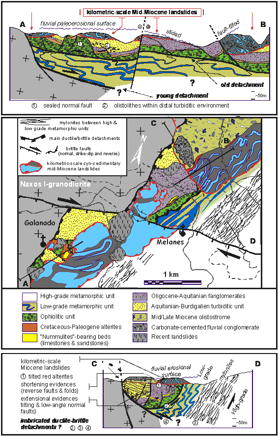
Geological map and cross-sections of the Galanado-Melanes upper Unit and tectonic borders
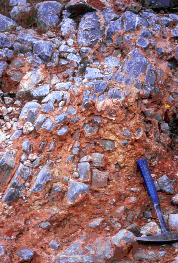
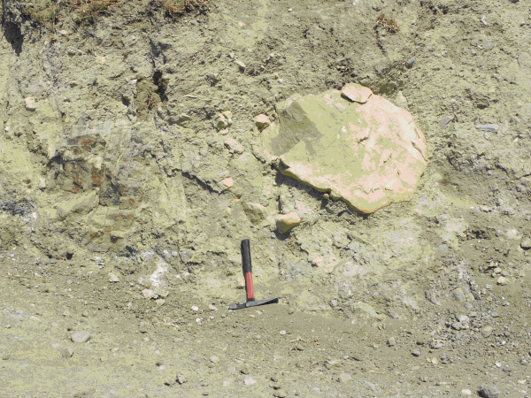
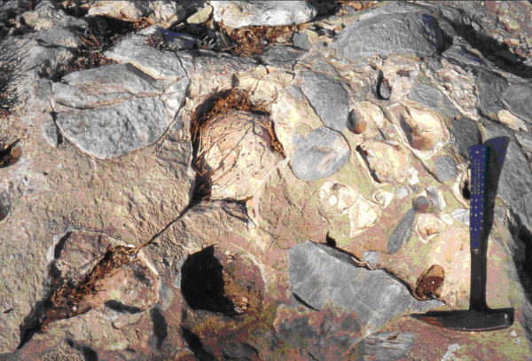
Figure 22. tilted erosional surface
tilted erosional surface facing South (viewed from the mylonite East of the landslide)
9h30-9h45: Melanes-Aghios Thaleleos
Stop 2: Cross section Aghios Thaleleos (Figure 18)
(Hibsch C.)
This cross section allows to observe various facies from the metamorphic upper unit and overlying non-metamorphic upper unit and also reach the contact with the granodiorite :
• Low grade green-schists facies rocks from an equivalent to the so-called Dryos Unit described in Paros Island
• Ophiolitic Unit and its paleo-alterite of Cretaceous or Paleogene age?
• Paleogene molassic series revealing shallow marine conditions at its base (limestones and sandstones with nummulites). This unit did not yet record the unroofing of the MCC.
• Aquitanian-Burdigalian marine turbiditic sequences with some olistolithes coeval with the thermal pulse in the migmatitic dome and which is progressively registering the unroofing of the MCC (first pebbles of metamorphic origin)
• Granodiorite affected by solid state deformation
(Observation of the paleokarst, the fluvial conglomerate and the olistostrome (Figure 19); (Figure 20); (Figure 21) are optional according to time)
It also presents some tectonic features that sould be taken into account in the discussion regarding the transition from thickening to thinning of the crustal accretionary wedge.
• tectonic contact between the low grade metamorphic unit and the non-metamorphic ophiolitic nappe
• reverse faulting between the ophiolites and Paleogene molasses but also widespread low-angle normal faulting in all sediments
• normal faulting affecting the landslide and the paleo-erosional surface
• tectonic contact between the sedimentary unit and the granodiorite (faults and associated folds)
12h00-12h30: Melanes- Aghios Ioannis
Stop 3: Granodiorite cataclastic detachment (Aghios Ioannis) (Figure 23)
(Siebenaller L.)
This outcrop displays a cataclasic detachment at the top of the granodiorite pluton and various expressions of fluid circulations. The most prominent one is expressed by a thick chlorite and epidote rich gouge with feldspar clasts that potentially correspond to retrogression of the granodiorite associated with (meteoric ?) fluid circulation during the development of the cataclastic detachment. This gouge is cemented by quartz attesting for the circulation of silica-saturated fluids. This silicification is also affecting the non-metamorphic upper unit sandstones and conglomerates just above the detachment. ENE-WSW trending faults cross-cut the gouge and are associated with goethite, siderite and calcite attesting for the circulation of Fe and Ca rich fluids in these rocks as they were exhumed closer to the surface.
Discussion arise about the role of the different cataclasites, some being associated with the detachement while others are clearly oblique and sometime partly reactivated as brittle normal faults (Figure 23).
13h30-14h00: Lunch break
14h00-14h30: Aghios Ioannis - Hora
(Siebenaller L.)
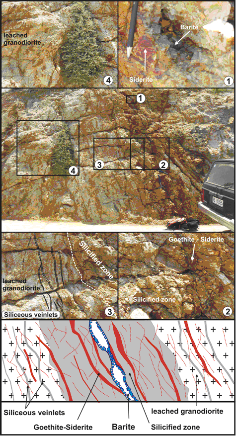
This outcrop completes the chronology of fluid-related alterations and precipitations within the granodiorite on the E-W trending faults. The granodiorite is characterized by a pervasive C/S fabric with a NW-SE trending stretching lineation and top-to-the northwest sense of shear. The granodiorite displays clay-rich zones where biotite and chlorite are absent. This suggests leaching of the granodiorite by hydrothermal fluids that have altered Fe-Mg and Si rich minerals replaced by clays. These zones contain ENE-WSW quartz veins cross-cut by goethite, siderite, calcite and barite mineralizations (Figure 1) 24). To the south of this zone, structurally below, the granodiorite is cataclastic and chlorite-rich.
Figure 23. Aghios Ioannis
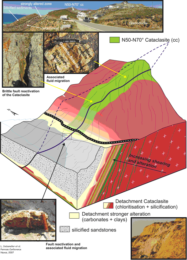
3D view of the detachment affecting the granodiorite (Aghios Ioannis) and associated fluid migrations
16h00-16h30: Hora - Stelida
(Siebenaller L.)
This outcrop shows the contact between the granodiorite detachment zone and the juxtaposed silicified sediments. The granodiorite below the contact is affected by numerous pseudotachyllites. These outcrops, not so far from the lodging, may allow wandering in small groups according to the points of interest (sismotectonic and ductile fabric, fluid migrations affecting the sediments and sedimentary evidences for the last steps of the exhumation.