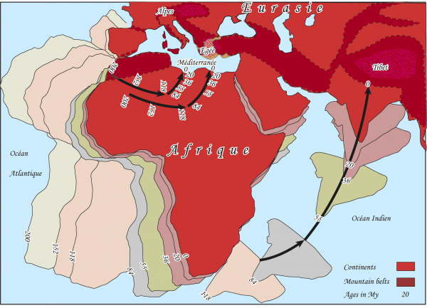
The geodynamic evolution of the Mediterranean is controlled by Cenozoic convergence between the African and Eurasian plates (Figure 1). This convergence was accommodated by closure and subduction of the Tethys Ocean and development of the Alpine crustal accretionary wedge. The geodynamic evolution of the Mediterranean is also marked by opening of continental and oceanic basins above retreating slabs.
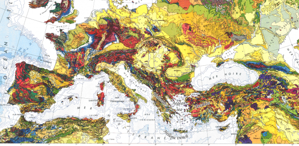
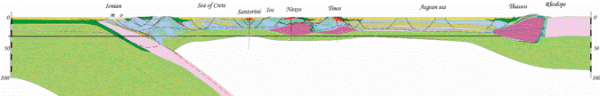
In the eastern Mediterranean, the continuity of the high mountainous massifs of the Hellenides in mainland Greece and the Taurides in Turkey is disrupted by the presence of the Aegean basin (Figure 2). The thickness of the continental crust in this region ranges from 50-55 km beneath the Taurides and the Hellenides to 15-20km beneath the Aegean and Cretan seas with intermediate thicknesses of 45km beneath Crete and 35km beneath the Cyclades (Makris and Stobbe 1984).
The eastern Mediterranean Cenozoic geodynamic evolution is characterized by convergence between the African and Eurasian lithospheric plates accommodated at the lithospheric scale, by subduction of the Aegean slab since at least the early Cenozoic and currently active along the Hellenic trench (Spakman 1986) (Figure 3). Southward migration of calc-alkaline magmatism relative to the upper plate suggests southward slab roll-back for at least a 1000km (Fytikas, Innocenti et al. 1984). At the crustal scale, convergence is marked by the development of the Hellenic and Aegean accretionary wedges that are exposed respectively in the Hellenides and in the Aegean Sea. The Hellenides are subdivided from North to South in the internal and external hellenides. The internal Hellenides expose the Rhodope and Pelagonian zones representing continental blocks separated by the Vardar suture zone (Auboin 1973; Bonneau 1982; Jacobshagen 1986; Papanikolaou 1989). The external Hellenides are composed by the Pindos, Gavrovo, and Ionian zones representing sedimentary cover nappes overthrusting the pre-apulian zone to the south (fig. geological map of Greece). These various zones have recorded events from subduction, obduction, and crustal thickening to crustal thinning within the context of convergence between Africa and Eurasia during Tertiary times (Dewey and Sengor 1979; Bonneau and Kienast 1982; Dercourt, Zonenshain et al. 1986).
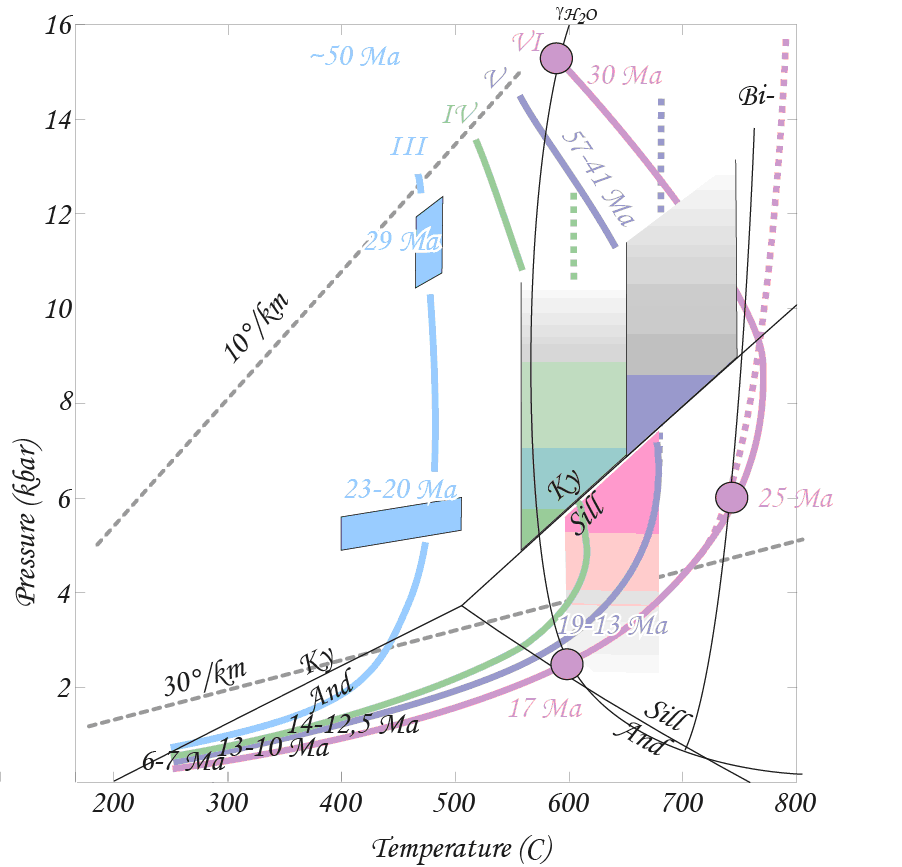
In the Aegean sea, the Attic-Cycladic Massif (Figure 4) forms a belt of metamorphic rocks exhumed along low-angle detachments (Lister, Banga et al. 1984). These metamorphic rocks have first recorded an Eocene high-pressure/low-temperature metamorphism evidenced by blueschist to eclogite facies (Andriessen, Boelrijk et al. 1979; Bonneau and Kienast 1982; Wijbrans and McDougall 1988; Buick and Holland 1989; Avigad and Garfunkel 1991; Keay 1998; Lips, White et al. 1998; Keay, Lister et al. 2002). The high-pressure/low-temperature metamorphism is overprinted by a Miocene medium pressure/medium temperature metamorphism evidenced by a greenschist to amphibolite-facies locally reaching partial melting (Jansen and Schuiling 1976; Andriessen, Boelrijk et al. 1979; Altherr, Kreuzer et al. 1982; Buick and Holland 1989; Keay 1998; Keay, Lister et al. 2001; Keay, Lister et al. 2002).
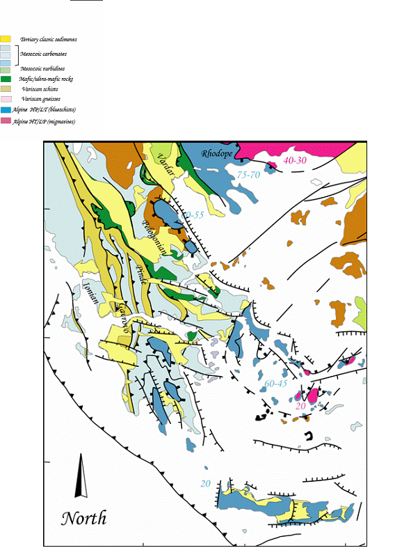
Figure 5. Aegean Sea
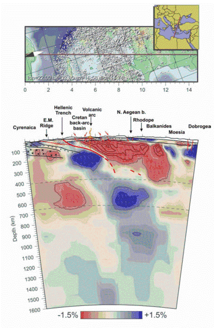
North-South lithospheric section from the Hellenic trench to the Rhodope massif across the Aegean sea (same legend as Fig. 4)
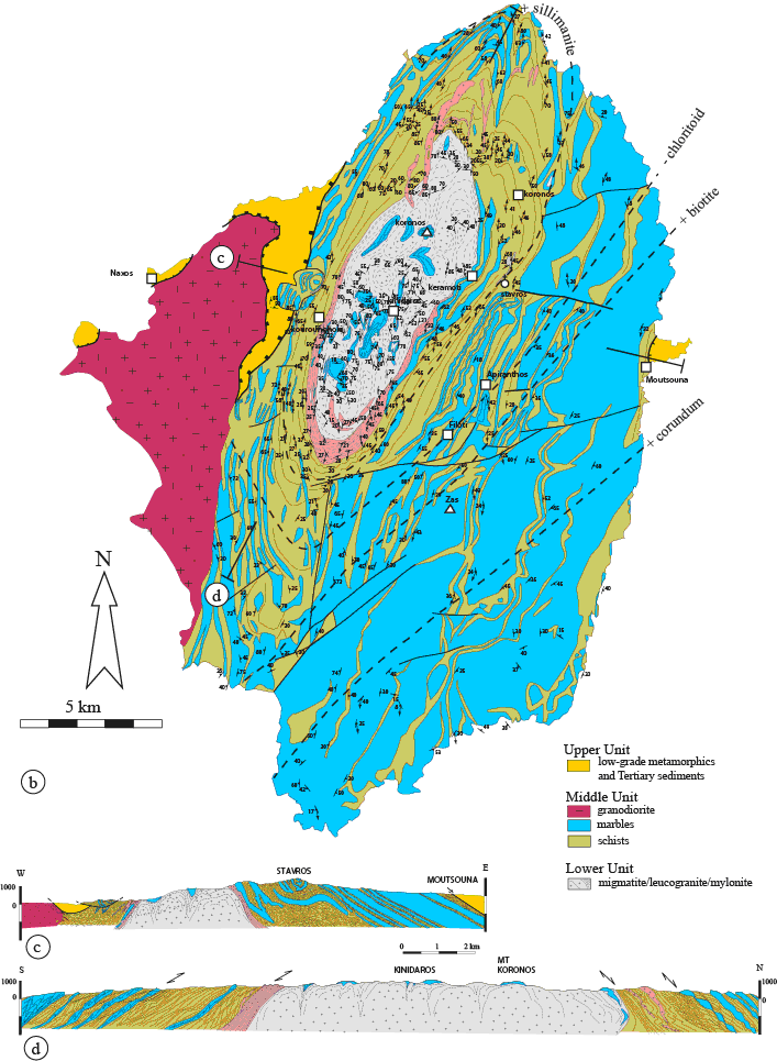
The island of Naxos in the Attic-Cycladic Massif (Figure 7) displays the most complete structural cross section of the Cyclades showing metamorphosed ante-Mesozoic rocks and Cenozoic granitoids juxtaposed to Cenozoic sediments or weakly metamorphosed rocks along detachment systems (Jansen 1973). Three tectonic-metamorphic units are distinguished. The upper unit, occurring structurally above the detachment, is composed of low-grade marble, schists and serpentinites that are overlain unconformably by dominantly detrital Cenozoic sediments (Jansen 1973). The middle and lower units are composed of high-grade metamorphic rocks located below the detachment. The middle unit is composed of a schists and marbles sequence containing mafic and ultramafic boudins (Jansen and Schuiling 1976). The middle unit is dominated by marbles at the top and by schists at the bottom. The lower unit is made of migmatites and marbles exposed in the core of an elliptical dome mantled by the metamorphic rocks of the middle unit. The structure of the island is asymmetric on an W-E section. First, the middle unit shows a structural section of about 1km to the west and 4km to the east of the dome. Second, in the western part of the island, the middle unit is intruded by a granodiorite pluton.

The structural section through the middle and lower units is marked by a medium pressure/medium temperature metamorphic gradient ranging from greenschist facies in the southeastern part of the island to amphibolite facies reaching partial melting (1 GPa, 750°C) as evidenced by migmatites exposed in the centre of the dome (Jansen and Schuiling 1976; Buick and Holland 1989; Avigad and Garfunkel 1991; Duchêne, Aïssa et al. 2006) (Figure 6). High pressure/low temperature metamorphism is only represented by relics of blueschist facies minerals, such as Na-amphibole and jadeite (1 GPa, 350°C), in the metamorphic rocks of the south of the island.
Since the 1970's, numerous studies using different geochronological methods (Ar/Ar, K/Ar, Rb/Sr, Sm/Nd and U/Pb methods performed on various minerals) have been carried on the metamorphic rocks of Naxos. In the lower unit, the peak of the medium pressure/medium temperature metamorphism, corresponding to the onset of the partial melting in the core of the island, is constrained prior to 20-21 Ma by U/Pb dating on zircon crystals from migmatite samples (Keay et al. 2001, Martin et al. submitted). In the middle unit, the age of the medium pressure/medium temperature metamorphism is constrained after 19.9-27 Ma by Ar/Ar dating on phengite (Wijbrans and McDougall 1988). Whereas the migmatites of the lower unit have solely preserved the medium pressure/medium temperature paragenesis, metamorphic zircon rims yield scattered U-Pb ages around 50 Ma (Keay 1998, Martin et al. 2006, Martin et al. submitted), consistent with the 40-50 Ma ages obtained with Ar/Ar and Rb/Sr methods in samples from the south of the island (Andriessen et al. 1979; Wijbrans and McDougall 1986; 1988). (Keay 1998; Keay, Lister et al. 2001; Martin, Duchêne et al. 2006). 40Ar/39Ar ages of white micas and biotite performed in the middle and lower units indicate an age gradient from ~ 45 Ma in the metasedimentary rocks in the southeastern part of the island to ~ 10 Ma in the migmatites (Andriessen, Boelrijk et al. 1979; Altherr, Kreuzer et al. 1982; Wijbrans and McDougall 1988). The granodiorite pluton intruding the middle unit in the wester part of the island is dated at ~11 Ma by U/Pb and Ar-Ar methods (Wijbrans and McDougall 1988; Keay, Lister et al. 2001). The mineralogical and geochemical characteristics of the granodiorite suggest a composite origin combining crustal and mantellic protoliths.
Various models have been proposed to account for the tectonic evolution of Naxos. Early models recognized the allochtony of the sedimentary and low-grade unit (Auboin 1973; Bonneau 1982; Jacobshagen 1986) and interpreted it as a nappe structure emplaced by gravity sliding above the metamorphic lower structural unit. The complex structure of the marble and schist sequence characterized by recumbent isoclinal folds and HP/LT metamorphic assemblages has been attributed to burial and nappe emplacement in a plate convergence context (Bonneau, Geyssant et al. 1978; Bonneau and Kienast 1982). Based on a petrological study of the metamorphic rocks of the island, Jansen and Shuiling (1976) recognized the importance of partial melting and first proposed that the dome results from diapiric rise of the migmatites. Gautier et al. (1993) reinterpreted the basal tectonic contact of the sedimentary unit as a low-angle detachment and refined this model proposing that the dome corresponds to upwelling of the low-viscosity migmatites during regional extension. This model has been further explored using 40Ar/39Ar ages (John and Howard 1995), and fission track and U-Th/He ages on apatite (Brichau, Ring et al. 2006) indicating a general trend of northward cooling interpreted as progressive exhumation for the hanging wall of the single detachment mapped by Gautier et al. (1993, 1994). Alternatively, several authors consider that the dome structure and complex polyphased folding of the marble and schist sequence result from the combined effects of E-W shortening and regional top-to-the-NNE shearing (Urai, Shuiling et al. 1990; Buick 1991; Avigad, Ziv et al. 2001). More recent work on structures in the migmatites and geometric characteristics of the granitic vein network intrusive in the marble and schist sequence suggests that the development of the dome corresponds to upwelling of a partially molten layer in a regional context of top-to-the-northeast shearing (Vanderhaeghe 2004). The observations made during this field trip will allow addressing these models.
