Remote sensing is the non-contact recording of information about the earth’s surface, from the ultraviolet, visible, infrared and microwave regions of the electromagnetic spectrum, by means of instruments such as scanners and cameras, located on mobile platforms such as aircraft or spacecraft and the analysis of the acquired information by means of photo interpretive techniques, image interpretation and state-of-the-art of image processing (Sabins, 1987). Although, there appears to be a lack of physical contact between the remote sensor and the target, in reality there exists a link between the two, in the form of electromagnetic energy (visible, thermal, infrared radiation), force fields (gravity, magnetic) or acoustic waves (sonar). Remote sensors measure the relative variation of these forms of energy that is either emanating from the body or being reflected from it to recognize and make detailed studies.
For most of the atmospheric and earth surface observations, electromagnetic energy is considered to be the supreme medium for two reasons. Primarily, this is the only form of energy that has the ability to propagate through free space as well as a medium. Further, its property to interact with the media and the target in a variety of ways ensures the sensor to capture the subtle variations that exist in the nature of the earth features.
Every part of the earth reflects the light incident upon it depending on its optical characteristics. This information, which characterizes objects, is called "signatures". Different objects of the earth’s surface return different amounts of reflected / emitted energy in different wavelengths of the electromagnetic spectrum depending on the atmospheric windows (Figure 3), and this reflectance / emittance from each object depends on the wavelength of the radiation, the molecular structure of the object and its surface conditions. Vegetation, in general, appears green during daytime, because it reflects the green band of visible radiation preferentially, while absorbing other color bands of the visible radiations.
Detection and measurements of these spectral signatures enable identification of surface objects both from air borne and space borne platforms. But often, similar spectral response from different surface objects creates spectral confusion leading to misinterpretation and misclassification, which can be avoided by systematic ground data verifications. However, spectral variation in reflectance or emittance from objects is not the only characteristic of electromagnetic radiation that helps in establishing their signatures. Signatures basically comprise of any set of observable characteristics, which directly or in directly lead to the identification of an object and/or it’s condition. These characteristics are spatial information, temporal (for example, seasonal) variation and polarization effects. The spatial information relates to shape, size, texture, pattern, association, etc.
Figure 3. Spectral characteristics
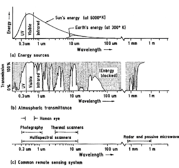
Spectral characteristics of energy sources, atmospheric effects and sensing system (after Nath et al., 2000).
Earth resources satellites collect information about the earth’s surface and transmit to the ground receiving stations. After carrying out initial corrections, two types of data products (visual imagery hard copy and computer compatible tapes (CCTs)) are generated for resources study. These data products are processed and interpreted for the identification and classification of different objects of the earth. Each satellite system is composed of a scanner with sensors. The scanner is the entire data acquisition system, such as the Landsat Thematic Mapper scanner or the SPOT panchromatic scanner (Lillesand and Kiefer, 2003). The sensor of a satellite, made up of detectors, is a device that gathers energy, converts it to a signal and presents it in a form suitable for obtaining information about the environment. A detector is the device in a sensor system that records electromagnetic radiation. For example, in a sensor system on the Landsat Thematic Mapper scanner there are 16 detectors for each wavelength band. Several characteristics of the common remote sensing system given in (Figure 3) have been described by Nath et al. (2000) are summarized in (Table 1).
Table 1. Characteristics of the common remote sensing system (after Nath et al., 2000)
| SR. No. | Characteristics of the Remote Sensing system |
|---|---|
| 1. | Circular orbits that go from north to south and south to north. |
| 2. | Sun-synchronous orbits, meaning that it rotates around the earth at the same rate as the earth rotates on its axis, so data is always collected at the same local time of day over the same region. |
| 3. | Records electromagnetic radiation in one or more bands. |
| 4. | It’s scanners produce nadir views (Nadir is the area on the ground directly beneath the scanner’s detectors). |
Many data acquisition options are available ranging from photography to aerial sensors using film, to sophisticated satellite scanners. A satellite system with detectors which produce digital data may be preferable for the reasons that the digital data can be easily processed and analyzed by a computer directly; the satellite is in orbit around the earth, so the same area can be covered on a regular basis for detecting change; once the satellite is launched, the cost of data acquisition is less than that for aircraft data; and satellites have very stable geometry, meaning that of remote sensing data is acquired from different types of satellites, viz., Landsat, SPOT, IRS-1B, IRS-1C, NOAA, etc.
Landsat has a 15m panchromatic sensor and a 30m enhanced Thematic Mapper sensor with 7 bands. SPOT has a 10m panchromatic sensor and a 20m multi-spectral sensor with 3 bands. IRS-1B has a 36m multi-spectral sensor with 4 bands. Raw remotely sensed data is not projected onto a plane. Therefore, rectification is necessary to project the data conforming to a map projection system before processing.
Several commercial software are used in the industry for the processing and interpretation of remotely sensed data, namely, ER-Mapper, Integrated Land and Water Information System (ILWIS) and Earth Resources Data Analysis System (ERDAS) developed by various software vendors.