Geographic Information System is a tool to efficiently capture, store, update, manipulate, analyze and display all forms of geographically referenced data. Many other definitions of a GIS have been evolved in different areas and disciplines (Clarke, 1995 and 2001; Burrough, 1986 and 1998; Duecker, 1979; Goodchild, 1992; and Star and Estes, 1990). According to Duecker (1979) geographic information system is a special case of information systems where the database consists of observations on spatially distributed features, activities or events, which are definable in space as points, lines, or areas. A geographic information system manipulates data about these points, lines, and areas to retrieve data for ad hoc queries and analyses.
All definitions of GIS recognize that spatial data are unique because they are linked to maps. A GIS at least consists of a database, map information, and a computer-based link between them. It stores data about the world as a collection of thematic layers, a pictorial representation of which is given in (Figure 1) to be linked together in spatial domain using geographical reference system. It lets the users to see, explore, and analyze data by location, revealing hidden patterns, relationships, and trends that are not readily apparent in spreadsheets or statistical packages. This simple but extremely powerful and versatile concept has proven invaluable in solving many real world problems from tracking delivery vehicles, to recording details of planning applications and managing natural resources.
Figure 1. The real world
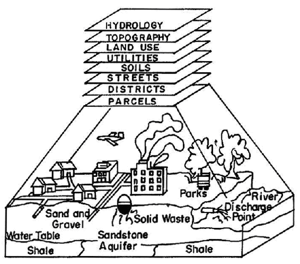
The real world consists of many geographic, which can be represented as a number of related data layers (after Nath et al., 2000).
GIS stores both spatial and aspatial data. The geocoded spatial data defines an object that has an orientation and relationship with other objects in two or three-dimensional space, also known as topological data and stores in topological database. On the other hand, attribute data stored in a relational database describes the objects in detail. GIS links these two databases by manipulating a one-to-one relationship between records of object of location in the topological database and records of the object attribute in relational databases by using end-user defined common identification index or code. Different components of a GIS are pictorially represented in (Figure 2).
GIS uses three types of data (point, line, and polygon/area type) to represent a map or any georeferenced data, and can work with both vector and raster geographic models. The vector model is generally used for describing discrete features, while the raster model is used for continuous features.
GIS uses both operational and analysis tools for generating thematic maps. There are several commercial GIS packages available in the industry, namely, ESRI Arc/Info and ArcView, MapInfo, AutoCAD MAP, Geographic Resources Analysis Support System (GRASS), IDRISI, Maptitude, and Microstation MGE developed by various software vendors.
Figure 2. Components of a GIS
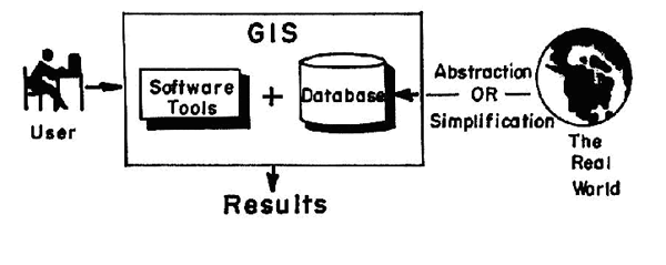
Pictorial representation of the components of a GIS (after Nath et al., 2000).