Tectonic development of the MHB
General overview
The Mesohellenic Basin corresponds to an assymetric syncline. On its western border, strata are generally steeply dipping eastward and are locally vertical to slighly overturned (Eocene and western Oligocene deposits). On the eastern border, the Paleogene formations are generally absent from outcrop, except in the South (i.e. Rizoma formation), and Miocene strata are gently dipping westward (Fig. 4).
Eocene strata are much more deformed than Oligocene and Miocene ones. The Oligocene Eptachorion Formation is uncomformably overlying the two folded small basins of Krania and Rizoma (Fig. 4).
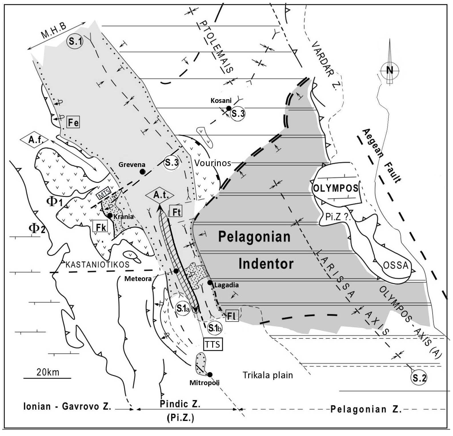
Oligocene formations appear mostly on the western side of the MHB while the Miocene strata rest onto the basement on the eastern side because of eastward migration of depocenters. The southern part of the MHB is more complex as the main syncline splits into two narrow synclines separated by a major structural high : the Theopetra-Theotokos Structure (TTS) (Pl. III-B). This complex structural high corresponds broadly to a main faulted anticline (Theotokos Anticline : At), with a major fault (Theopetra Fault: Ft) on its eastern border (Figs. 4 and 13). Moreover, in this southern part of the MHB, the total width of the basin domain is much smaller than northward. This narrowing is related to the development of a particular structure raised within the basin basement : the Pelagonian Indentor (Fig. 13A).
Figure 13A. Synthetic structural map of the MHB and internal zones of Hellenides
Synthetic structural map of the MHB and internal zones of Hellenides (modified after Ferriere et al., 2004). Note the relationships between the Pelagonian Indentor (double thin lines bounded by double dashed lines for the northern flexure) and: i) the Theopetra-Theotokos Structure (TTS=At+Ft) , ii) the Rizoma elongated subbasin (S.1B) on the west, and iii) the structural saddle of Kozani and Krania sub-basin on the north-west (S.3) . We can also observe that this transverse crustal structure( S.3) does not present any significant strike-slip offset that could be the result of a movement along the TTS. S.(1 to 3): Synclines ; A: Anticlines, Af: Filippi anticline, At: Theopetra-Theotokos anticline or structural high ; Fk, Fe and Ft: faulted-flexures of Krania, Eptachorion and Theopetra.
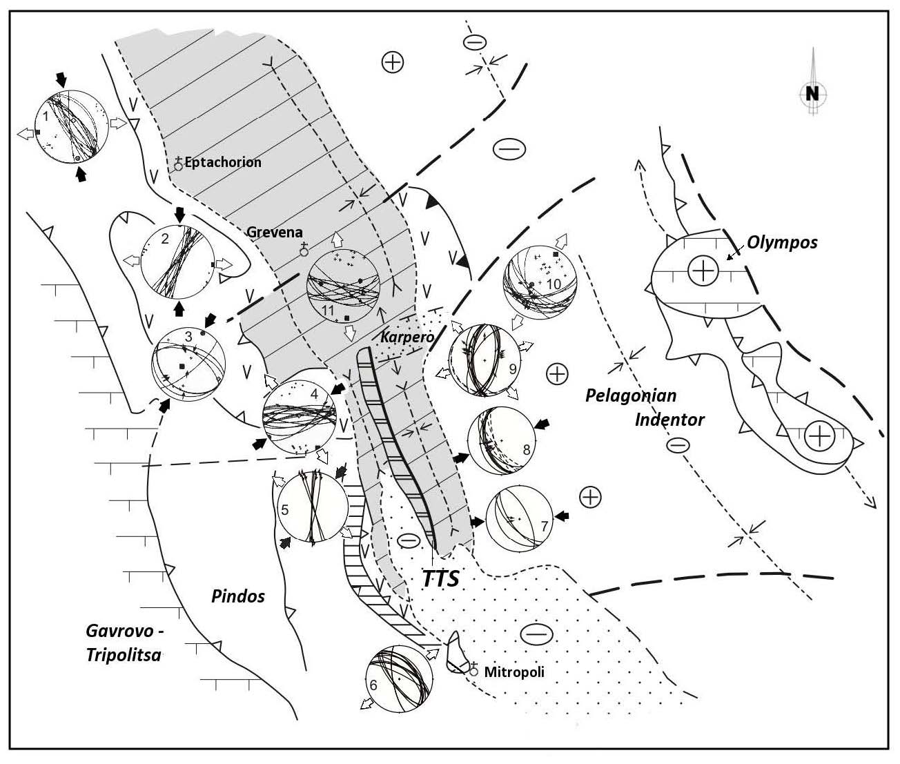
Figure 13B. Some stress stereoplots relative to the MHB (lower hemisphere)
Some stress stereoplots relative to the MHB (lower hemisphere). Stereoplots 1 to 4 and 10-11 after Vamvaka et al., [2006]; 5 to 9 after Ferriere et al., [2011]. On stereoplots, blacks arrows represent compressional directions from reverse faults; white arrows extensional directions from normal faults. Sites 3, 7 and 8 in late Eocene series: reverse faults developed during the compressive late Eocene event. Sites 1, 2 and 4: Oligocene-early Miocene strike-slip event, after Vamvaka et al., [2006]. Site 6: synsedimentary early Miocene normal faults with 2 to 10 m normal offsets (no reliable striation could be observed on these fault planes) (Pl. III-E). Site 5 in Oligocene series: strike-slip faults. Sites 9 (in Oligocene series), 10 and 11: normal faults developed during Oligocene to Quaternary times.
Major faults and structures, mostly parallel to the basin strike, have been recognized by previous authors but with various interpretations [Doutsos et al., 1994 ; Ferrière et al., 1998, 2004; Vamvaka et al., 2006 ; Ferrière et al., 2011]. Small scale deformations are still poorly constrained in kinematics and age (Fig. 13B).
Some results on detailed brittle deformation analysis have been firstly proposed by Doutsos et al. [1993, 1994] but they were poorly constrained in age. The chronology of tectonic deformation of the MHB has been proposed from analysis of major and minor deformation patterns [Ferrière et al., 1998, 2004, 2011; Vamvaka et al., 2006]. These results on tectonic deformation show that the present MHB is the result of successive tectonic episodes among which the main one is late Eocene in age.
The southwestern border of the MHB
The deposits from this southwestern border of the basin are essentially Oligocene in age, except in the Krania area (late Eocene) and in the Mitropoli area (early Miocene) (Fig. 3). Various tectonic structures were described from this border and they can be complex and polyphased [Ferrière et al., 1998, 2004, 2011, Vamvaka et al., 2006].
Deformation within Oligocene series
According to some authors, the contact between the Oligocene deposits and the basement is outlined by a large fault. However the interpretation differs from a large westward dipping thrust fault [Doutsos et al., 1994] or a steeply dipping strike-slip fault [Zelilidis et al., 2002; Vamvaka et al., 2006] (cf. Fig. 18).
We consider that three segments have to be distinguished on this MHB-SW border, from North to South:
- i) North of Krania (northern MHB, Figs.1, 3 and 13A) Oligocene series are stratigraphically resting unconformably over the basement with high dips to vertical ones (North of Alatopetra) and even locally overturned (North of Eptachorion). There is no continuous fault along this deformed border but mainly some collapse structures. This part of the western border corresponds basically to a faulted flexure (Fe, Figs. 4 and 13A) [Ferriere et al., 1998, 2004].
North of Alatopetra (Figs. 3 and 13A), the development of the Filippi anticline seems to control the progressive tilting of Oligocene strata, indicating that the development of this faulted flexure is at least partly Oligocene in age (Pl. III-D).
- ii) East of Koziakas range (southern MHB, Fig.1B), a major steeply dipping fault separates Oligocene marls from Mesozoic limestones of Koziakas Range (Fig.13A and cf. Fig 16A-B). This fault evokes a normal fault with an overall large offset toward the basin, but small scale deformations next to the fault plane reveals some reverse motion. The age of deformation, and possible inversion along this fault, could not be established in that area.
- iii) East and South of Krania (central MHB, Fig.4C), Oligocene strata rest unconformably over the ophiolitic basement with moderate tilting toward the basin (dipping NE, 10 to 40°). These areas confirm the absence of a continuous large fault bordering to the west the Oligocene formations of the MHB.
Figure Plate III. Upper series (A) and Tectonique (B to H)
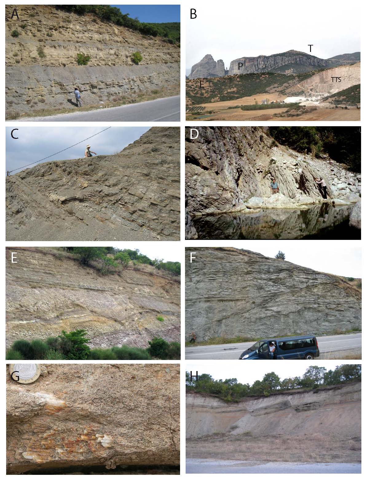
A) Ondria Fm near Ellinokastron (SE MHB) : view of the upper, clastic part of the formation showing sandstone and siltstone alternations. This deposit is a part of the youngest formation of the MHB fill in the south of the basin. B) View of the TTS high (TTS as Cretaceous limestone quarry) with overlying Miocene Meteora conglomerates (P: Pentalofon) on its western flank covered by the Tsotyli conglomerates (T) in the background. The hills in between are composed of Oligocene Eptachorion deposits (E). C) Krania Fm (late Eocene): metre-thick slumps in the lower part of Krania Fm. The scale in the sky is the wellknown Pr. Piper. D) Steep dips (60-70°) of Lepidocyclin-bearing marly beds forming the base of Eptachorion Fm at the SW-MHB border (north of Alatopetra). These beds rest above Cretaceous limestones (to the left). E) Synsedimentary normal faults within early Miocene deposits (Pentalofon s.l.) near Mitropoli, composed of siltstones, sandstones and conglomerates. These SE dipping faults are sealed above an unconformity by a westward onlapping deposit of similar facies as those below. F) Reverse fault across sandstones of the Pentalofon Fm. Note the slump at their base. G) Strike-slip features in the Oligocene deposits near Theotokos : low dipping slickensides (8 to 10° N), subparallel to the stratal dip (lower surface) are found on subvertical fault planes directed NS. The slickensides indicate a dextral motion along the fault. H) Normal faults on the border of the post-middle Miocene basin of Karpero. This recent basin is striking ENE-WSW.
Structures in other formations on the SW border of the MHB
Deformations of Eocene deposits from the SW border: the Krania area
The Eocene series of the Krania area (Fig. 14) are the oldest (Lutetian to late Eocene) and the most deformed strata within the whole MHB showing faults, folds and also a lot of olistolites and slumps (Pl. III-C).
These series were deposited in a restricted area corresponding to the Krania subbasin that is bounded to the west by a large flexure striking parallel to the MHB axis. This flexure shows vertical to overturned eocene strata and faults dipping roughly vertically (Fk, Figs. 13 and 14). The faults offsets seem apparently relatively moderate because the main fault separate the ophiolitic basement from the basal conglomerates of Eocene subbasin constituted of ophiolitic detritus and blocks.
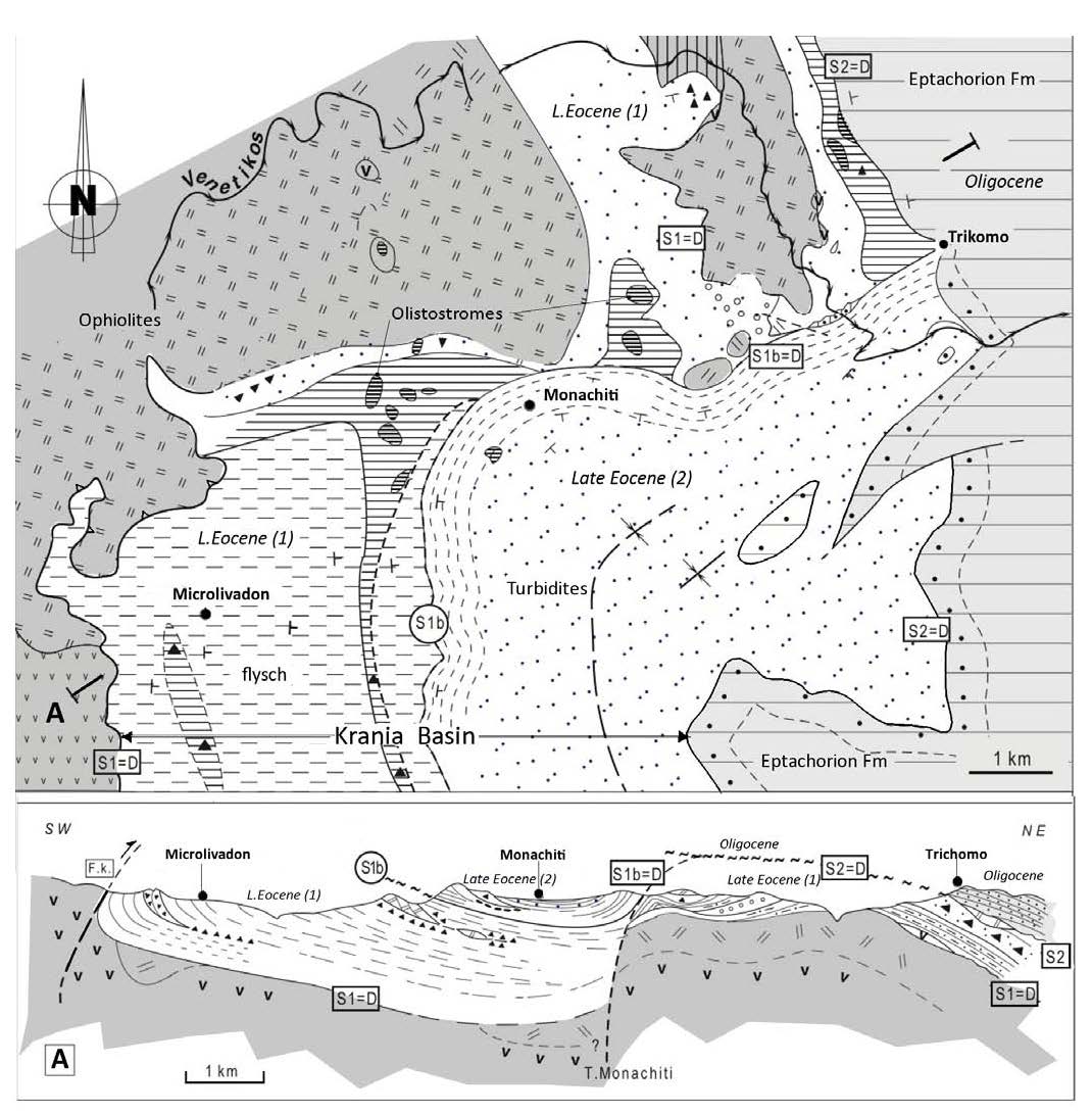
Figure 14. Geologic map and cross-section of the northern border of the Late Eocene Krania subbasin
Geologic map and cross-section of the northern border of the Late Eocene Krania subbasin; location: see Fig.3 (modified after Ferriere et al., 2004). L. Eocene (1) and (2): Late Eocene Krania lower series (1) and Late Eocene Krania upper series (2). T. Monachiti: Monachiti Transverse structure. Lower Krania series: Points: fine grained sandy bay deposits; small circles: well rounded conglomerates; olistostromes: large olistostromes with a breccia matrix (horirontal lines on the map; black triangles on the cross-section) and pluridecametric, massive or little brecciated olistoliths (patches with thick horizontal lines on the map, limestones blocks on the cross-section). Upper Krania series: turbidites (flysch) above thick sandstones (dashed lines). Eptachorion Oligocene Formation: conglomerates at the base (points) and sandstones above. S (S1, S1b, S2) Surfaces indicating major tectonic events; D: angular unconformities (see also Fig. 6). Vertical and horizontal scales are similar (no vertical exaggeration, v.e.=1).
Eocene strata from Krania subbasin, where close to the faulted flexure (e.g west of Microlivadon), are locally affected by decametric reverse faults with an eastward vergence (Fig. 14). The deformation can be attributed to the late Eocene main compressional episode as the Oligocene series are sharply unconformable on top of vertical eocene beds.
Deformations in Early Miocene series from Mitropoli area, Southern MHB
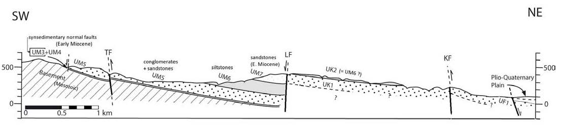
The Mitropoli area (Fig 15) is characterized by the presence of thick siliciclastic series, early Miocene in age, resting locally on top of Late Oligocene reefal limestones or, more generally resting directly on top of the Mesozoic basement of the Koziakas and Pindos Ranges (Figs.1B and 13A). These strata are gently dipping, 20 to 30° NE, toward the basin axis (Fig. 15) [Ditbanjong, 2013].
Figure 15. Cross-section in the Mitropoli area (southwestern MHB)
Cross-section in the Mitropoli area (southwestern MHB). The detritical series is only of Early Miocene age. Synsedimentary normal faults are present at the base of the series. They are responsible for the development of the MHB in this area.
Some steeply dipping large faults, NW-SE directed, are crosscutting the whole early Miocene series. They are thus younger than the early Miocene but they could not be attributed to a precise episode of deformation (Fig. 15). However, some other faults observed in the earliest Miocene strata are undoubtedly synsedimentary (Pl. III-E). The direction of extension could not be constrained precisely because of the lack of reliable striations on fault surfaces. From the spatial distribution of the fault planes, this extensional deformation has to be roughly NE-SW directed (Fig.13B, stereonet no.6). These synsedimentary faults represent the creation of a depocenter in this southern part of the basin during the early Miocene, later than the other parts of the MHB.
These listric synsedimentary faults are decametric in scale with offsets up to several meters. They are therefore not regarded as crustal faults but they reflect the deepening of the depocenter and the apparition of a significant slope toward the basin (toward the NE). The progressive onlap of marine coarse- grained followed by fine-grained sediments over the listric faults illustrates the progressive filling of that depocenter on an eastward dipping slope.
The eastern border of MHB
The eastern border of the Mesohellenic Basin is characterized by the onlap of the most recent deposits of the basin, early to middle Miocene in age, over the Pelagonian basement (Figs. 1 and 4). The basin strata are generally gently dipping westward, toward the axis of the MHB. In the southern MHB, these recent deposits are covering the small Eocene Rizoma sub-basin. Regarding the tectonic characteristics of this basin border, two segments have to be distinguished depending on the presence (southern segment) or the absence (northern segment) of the Pelagonian Indentor (Fig.13A).
Eastern border structures in the northern Segment
This border of the MHB shows, at least locally, some normal faults but the outcrop conditions and the widespread recent alluvial deposits do not allow to demonstrate a clear continuity along these faults (e.g. Orestikon sheet, Savoyat et al., 1971b). However, in many areas the Miocene series of Tsotyli Formation are unconformably covering the Pelagonian basement with a moderate dip whereas the Pelagonian basement is much higher laterally eastward. It implies a significant offset of the Pelagonian basement to account for this shift in elevation of the basement.
Eastern border structures in the southern Segment
In the southern MHB, the eastern boundary of the basin shows a westward shift because of the presence of the Pelagonian Indentor (PI, Fig. 13A) responsible for higher elevation and westward indentation of the basin. In this particular area, various Tertiary formations rest unconformably directly on top of the Mesozoic basement: late Eocene Rizoma Formation, early Miocene Tsotyli Formation, and early to middle Miocene Ondria Formation. The complex onlap relationships over the basement reveal a succession of tectonic movements within that area during the whole tertiary evolution of the MHB.
Some subvertical faults, directed NW-SE, can be observed on the border between the Pelagonian Indentor and the MHB (Figs. 16A and 16B). At least one of these faults shows an important normal motion outlined by the downward motion of Late Cretaceous limestones relative to the Triassic marbles. This particular fault is unconformably covered by Clypeaster-bearing limestones of Ondria Formation, early to middle Miocene in age (see Fig. 16B, cross-section C). This fault is likely to have been active during Oligocene to early Miocene times.
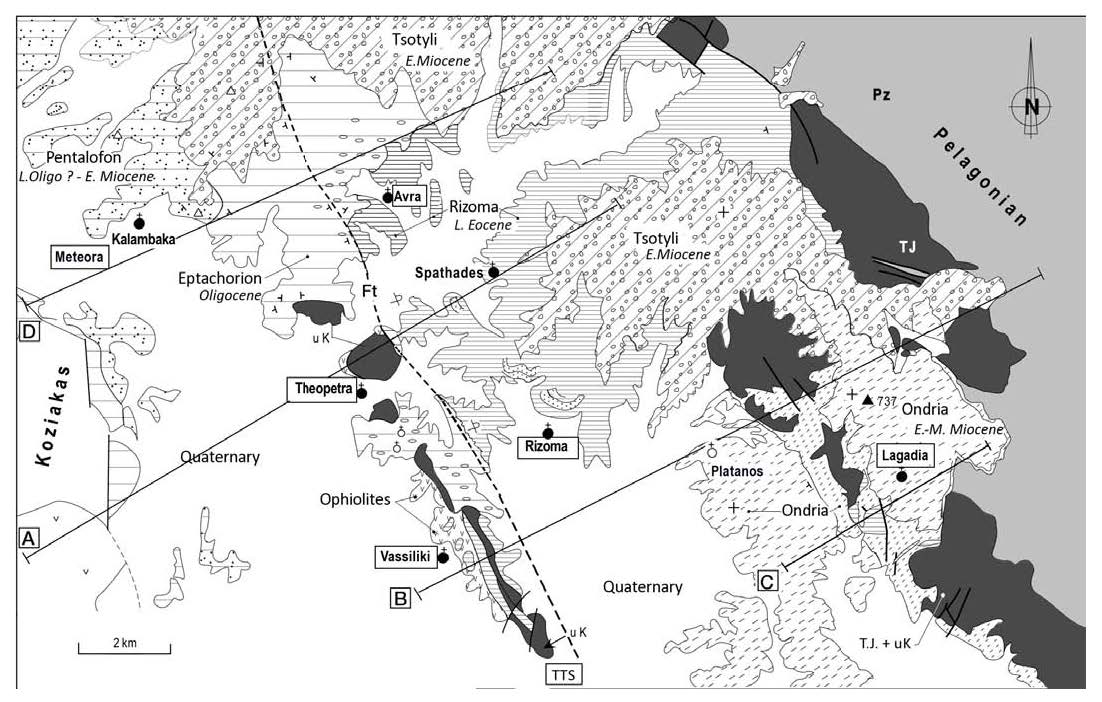
Figure 16A. Geologic map of the southeastern area of the MHB (Meteora)
Geologic map of the southeastern area of the MHB (Meteora) (modified after Ferriere et al., 2004). Abbr. Pz:Paleozoic gneisses and schists (Pz); Tj: Triassic-Jurassic marbles; uK: upper Cretaceous limestones of the Theopetra anticline (At) and South of Lagadia; L. Eocene: Late Eocene ; E.-M. Miocene: Early or/and Middle Miocene.
See Fig. 4 for cross-section D and Fig.16B for cross-sections A, B and C. Rizoma Formation: Late Lutetian-late Eocene clastic limestones overlaid by late Eocene unifites or deltaic sandstones (Rizoma sub-basin). Eptachorion Formation: Oligocene conglomerates (ellipses), sandstones and marls. Pentalofos Formation: Lower Meteora Conglomerates. Tsotyli Formation: gneiss-rich Upper Meteora Conglomerates. Ondria Formation: Early-Mid Miocene Echinid-rich limestones (small oblique dots), sandstones (turbidites) and Globigerinidae marls (large oblique dots). TTS: Theopetra-Theotokos Structure.
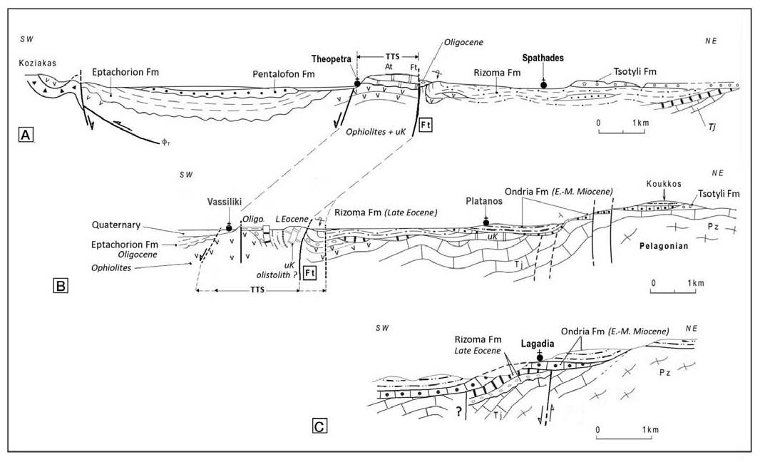
Figure 16B. Cross-sections (A to C) of the MHB southern area
Cross-sections (A to C) of the MHB southern area (see Fig.16A for location). Abbr.: Tj, uK, E.-M. Miocene, Fm, see Fig 16A. At and Ft: Theopetra Anticline and Fault
Late Eocene Rizoma Formation: i) Conglomerates (circles) and limestones (squares) at the base of Rizoma sub-basin and ii) Upper Eocene unifites and deltaic sandstones of the Rizoma sub-basin (dotted lines and points) ; uK: upper Cretaceous limestones basement or olistolites in late Eocene deposits. Oligocene Eptachorion Fm: conglomerates, sandstones and marls. Pentalofon Fm: Lower Meteora Conglomerates. Tsotyli Fm: Upper Meteora conglomerates. Miocene Ondria Fm: with Echinid-rich limestones (lower beds) sandstones and Globigerinidae marls (upper beds). TTS: Theopetra-Theotokos Structure. Vertical and horizontal scales are similar (no vertical exaggeration: v.e.=1).
Some recent deformations can also be outlined from this area because the youngest Ondria Formation is affected by flexural folding particularly developed on the Pelagonian Indentor border (Fig. 16B). We consider therefore that this folding can be controled by some westward and/or vertical motion of the Pelagonian Indentor after the Middle Miocene.
The Theopetra – Theotokos Structure: synsedimentary tectonic activity in the southern MHB
Description of the Theopetra – Theotokos Structure (TTS)
The TTS is a 40 km long complex structural high separating the southern MHB in two synclines, the western one occupied by the Pentalofon Formation, the eastern one by the Tsotyli Formation (Fig. 3). This structure includes two distinct areas with pre-MHB basement outcroping in the Kalambaka area [Savoyat et al., 1972a] and further North on the Agiofillion geological map [Mavridis and Matarangas, 1979] also referred in earlier work as the Theotokos thrust [Doutsos et al., 1994]. We demonstrated that both of these separate areas represent outcrops of a single complex structure, the TTS, that controlled the basin geometry in this zone since the late Eocene [Ferrière et al., 1998; 2004; 2011].
The TTS structure is a complex faulted anticline in the axis of the MHB (Figs. 13A and 16). To the north, it is mainly a faulted anticline within Oligocene strata (Theotokos anticline, A.t, Fig. 13A). In the South, this anticline is dissected by faults and represents therefore a complex fault zone. The main fault appears on the eastern side of the TTS and corresponds to the Theopetra Fault (Ft, Figs. 13A and 16). It is a major boundary within the basement as ophiolites appear mainly west of the fault and are generally absent from the other side. Some faults must also separate the southern TTS from the Plio-Quaternary Trikala plain to the West. These suspected faults could not be observed from outcrop because of the recent cover of Quaternary gravels.
The TTS has a polyphased structural development as evidenced by successive unconformities (Fig. 16B). It controlled the depositional areas in the southern MHB from Eocene to Miocene times (see Fig. 20). It corresponds to the western boundary of the Rizoma outcrops, acting as a compressional structure with significant reverse motion along the Theopetra Fault. This reverse motion is clearly late Eocene in age as it affects the middle to late Eocene series and the fault is unconformably covered by Oligocene strata [Ferrière et al., 1998 ; 2004]. These Oligocene sediments are coarse conglomerates made of Pelagonien gneissic pebbles on the eastern flank of the TTS whereas they are mainly fine grained marls and fine sandstones on the western side in the Basin axis. The massive trapping of coarse material on only one side of the TTS supports also the high topographic position of the TTS during Oligocene times.
Moreover the TTS was also active during Miocene times. This is supported by the syn-tectonic fan of the early Miocene Lower Meteora conglomerates (LMC) that illustrates the differential uplift of the TTS at that time. This motion is responsible for the partition of Lower Meteora Conglomerates (LMC, Pentalofon Formation) on the West side from the Upper Meteora Conglomerates (UMC, Tsotyli Formation) on the East side of the TTS [Ferrière et al., 2011].
Origin of the TTS
The TTS developed only in the southern MHB in the front of a major indentation of the Pelagonian basement, the Pelagonian Indentor (PI, Fig. 13A). Both of these major Hellenic structures, the PI and the TTS, has therefore to be genetically linked [Ferrière et al. 2004, 2011]. The Pelagonian Indentor corresponds to a raised Pelagonian block transverse to the MHB that is bounded to the east by the Aegean fault (between Olympos and Thermaikos Gulf) and to the west by the TTS. The northern boundary of the Indentor is the NE-SW Kozani-Krania saddle (Kozani straight from Brunn {1956}; Kozani saddle from Aubouin [1959]), where some remnants of the Vermion nappe and Vourinos ophiolites are preserved (Fig. 1). The southern boundary of the PI is masked by the Larissa and Trikala plio-quaternary plains. As a consequence, the narrowest section of the MHB occurs in front of the PI.
The basal beds of late Eocene series of Rizoma subbasin are transgressive on old levels of the Pelagonian basement on the western boundary of the Indentor. This suggests that the PI was already elevated and highly eroded as early as the Late Eocene. The deformation induced by the development of the PI extends far outside the MHB. In the external zones, series preserved in Pindos zone, north of the PI, are younger (Eocene flysch) than those preserved to the south of the Kastaniotikos transverse structure, more or less in front of the PI (mainly Mesozoic sediments) (Fig. 13A).
In the internal zones, the PI coincides with the location of the Olympus and Ossa tectonic windows (Fig.13A). However, at least an important part of the uplift of these Olympus-Ossa ranges occurred more recently than late Eocene - Oligocene times [Godfriaux, 1968; Fleury and Godfriaux, 1975; Schermer et al., 1990; Schermer, 1993; Lacassin et al., 2007; Migiros et al., 2011].
The pre-Late Eocene elevation of the Pelagonian Indentor could have been linked to specific paleogeography and/or specific tectonic characters in that area, notably in relation with earlier structural development of the internal zones (Early to Middle Eocene).
Putting these results together, one may hypothesize that the transverse high extending from the PI to the Olympos was created by the eastward underthrusting beneath the Pelagonian continental crust at the end of Eocene times of a thick crustal body subducted from the west of the Pindos basin. This crustal body most likely corresponds to an heterogeneity of the Gavrovo- Tripolitsa Zone [Ferrière et al., 1998; 2004].
Tranverse structures across the MHB
The main transverse structures that affect the MHB are WSW-ENE directed and they are apparently associated with the observed longitudinal segmentation of the basin.
Krania sub-basin
The Late Eocene sediments of Krania sub-basin are the most deformed within the whole MHB. Important folding and reverse faulting are responsible for frequent subvertical bedding and the northern and southern boundaries of the sub-basin are transverse structures (Figs. 13 and 14).
To the north, it corresponds to the Monachiti-Trikomo Structure (MTS, Fig. 14).This structure was active at least during the late Eocene because it controlled the formation of a major unconformity between nearly horizontal Oligocene strata and the uppermost, locally subvertical, upper Eocene turbiditic sandstone strata of the Krania sub-basin [Ferrière et al., 2004]. The associated deformation caused the formation of a submarine slope, E-W trending and southward dipping, as shown by (i) olistostromes and olistolithic channels in the uppermost Eocene beds, (Pl. I-4) and (ii) the vergency of the conglomeratic alluvial fans in the lowermost Oligocene.
The orientation of this northern boundary of the Krania sub-basin and the SW-NE directed compressive deformation axis observed in the Krania sub-basin (stereonet no 3, Fig. 13B) suggest that the MTS could have developed as a WSW-ENE strike-slip fault zone as also suggested earlier [Papanikolaou et al., 1988]. The direction of a main decametric fold (near Trikomo), subparallel to the MTS, argue in favor of a large WSW-ENE directed flexure (Fig. 14) responsible for the NS steep depositional profile recorded in the upper series of the Eocene Krania sub-basin (from bay-fill to more southern basin floor-fan, via canyon-fills and large slumps (Pl. I-D and III-C).
To the South, the transverse border of the Krania sub-basin is less well documented, due to poorer outcrop quality. This southern boundary evokes a strike-slip fault zone that could have some reverse component [e.g. Panaya map; Koumantakis and Mataraga, 1980].
The Krania transverse borders are probably controlled by larger-scale transverse inherited structures, which define EW trending highs and lows of the Pelagonian substratum: the Pelagonian Indentor and the Kozani Saddle [Ferrière et al. , 2004] (Fig. 13A).
Other transverse structures
Some minor transverse faults appear within the large structural blocks (more than 10 km long) defined by the major transverse structures. Some of these second order transverse faults can be observed clearly across the TTS, notably south of Vassiliki (Fig. 16A). These steeply dipping faults have some vertical motion but also some significant horizontal displacement as attested by bedding offsets and subhorizontal slickenslides. These strike-slip faults are compatible in orientation with the NE-SW direction of compressional deformation and of the NE-SW direction of extensional deformation as deduced from analysis of other faults (see Fig. 13B).
Discussion on along strike lateral displacements
Longitudinal basin-scale strike-slip faults (NNW-SSE) have been proposed by Zelilidis et al. [2002], based on some microtectonic data [Doutsos et al., 1994] and interpretations of a few seismic lines. Still, these authors do not provide any precision about the importance of the displacements implied nor about their chronology.
South of Grevena (Fig. 8), some large strike-slip faults at the western basin border have been proposed [Zelilidis et al., 2002], but they could not be evidenced by field analysis. The contact between Eptachorion and Pentalofon Formations has been considered as a major strike-slip fault (Theotokos Fault in Zelilidis et al., 2002, Fig. 8), but it is clearly stratigraphic at localities it could be observed.
More recently, the MHB has been also considered as a pull-apart basin that developed along a dextral shear zone during Oligocene and early Miocene times [Vamvaka et al., 2006]. Some large dextral strike-slip faults, NW-SE to NNW-SSE directed, would therefore correspond to the borders of the MHB at that time. One of the possible large faults that would control the development of such a large pull-apart basin corresponds to the NNW-SSE directed fault bounding the TTS to the East. Kinematic indicators from that fault zone indicate mostly some eastward verging reverse movement [Ferrière et al., 2004] and no significant strike-slip evidence could be observed on this Theopetra Fault zone.
Moreover, there is no major right-lateral offset of the main crustal structures (e.g. Kozani saddle- Krania syncline,Fig. 13A and Fig.20-A to F) on both sides of the TTS. This suggests that strike-slip displacements have been necessarily minor during the MHB development. In addition, the lack of en-echelon folds and of vertical axis folding in Oligocene to Miocene series supports the idea that if there was eventually some strike-slip motion parallel to the basin, it has to be necessarily very moderate and cannot be considered as a major process controlling the development of a large pull-apart basin.
Along the TTS, there are some dextral strike-slip faults trending about N340°to N010°E, near Theotokos and in the Meteora area, near Kalambaka (cf. Fig. 3 and Pl. III-G). These faults are compatible with the dextral motions proposed by Vamvaka et al. [2006]. However, these faults affect all strata from the Cretaceous limestones up to the Burdigalian (UMC, Tsotyli Formation) and are therefore to be considered as Burdigalian or younger in age, at least for their youngest activities. Such a post-MHB tectonic phase has been described and well-documented by Tranos et al. [2010]. This deformation could also be associated with the Neogene opening of the Karpero depression (Figs. 3 and 13B).
Tectonic development of the MHB
Tectonic structures
The main structures of the MHB are NNW-SSE to NW-SE directed, parallel to the main syncline axis of the basin. Transverse structures, including the Krania sub-basin, are mainly restricted to the northern border of the Pelagonian Indentor (Fig. 13A).
Most results from brittle deformation analysis are generally poorly constrained in age [Doutsos et al., 1994; Ferrière et al., 2004; Vamvaka et al., 2006]. The most significant results are reported on Figure 13B. Despite this difficulty to obtain precise ages for the different stages of deformation, some authors proposed successive tectonic episodes to account for the basin development [Ferrière et al., 2004; Vamvaka et al., 2006].
Brittle deformation is largely dominated by normal faulting, including some syn-sedimentary normal faults observed in the southern MHB (Mitropoli area, Pl. III-G). Reverse faults are less common and are mainly developed within the Eocene series of Krania sub-basin, but major reverse faults also exist in Early Miocene formations (e.g. near Mitropoli, Kanalia fault, Ditbanjong [2013]) or in the northern MHB (Pl.III-F). Strike-slip faulting occurs but these faults do not seem to play a major role in the Basin evolution.
The major compressional structures are faulted flexures, parallel to the basin axis, and were developed mainly on the western side of the MHB (Fk, Fe, and Ft, Fig. 13A). Longitudinal segmentation of the basin has to be related to the Pelagonian Indentor that started its development at least as early as the Late Eocene.
Chronology of deformation
First episode of compressional deformation (45-34 Ma)
Important compressional deformation occurs in the Krania area during late Eocene sedimentation. This episode is responsible for a clear angular unconformity within these series, with turbidites on top of olistostromes bearing up to hectometric-scale olistoliths of Late Cretaceous limestones. The compression continues up to the end of Eocene times and the Oligocene stata are unconformably overlying these deformations. In the Rizoma area, reverse motion of this age are observed on the main faults as the Ft fault (Fig. 13A).
Second tectonic period (34-15 Ma)
It corresponds to the main development of the MHB. During this period, the basin evolves progressively as a NW-SE directed asymmetric syncline with a steeply dipping western border. Tectonic deformation attributed to this period result essentially in vertical motions with borders uplift and basin subsidence gradually migrating eastward. This evolution is accompanied by normal faulting, minor reverse and strike-slip faulting, and km-scale folding. The main shift of subsidence is eastward, but there is also a southward jump in subsidence during the Miocene, identified by the presence of early Miocene series at the base of the western side of the basin in Mitropoli area (Fig. 1) and deposition of middle Miocene series of Ondria Formation unconformably over the Pelagonian basement (Fig. 3).
The post-MHB period (15 Ma - present-day)
This last stage of the MHB evolution is characterized by major uplift processes. This is evidenced by the high elevation of the most recent turbiditic formations of the MHB, up to 700m in elevation for Ondria Formation in the southern MHB and more than 1000m elevation for Ondria- Orlias Formations in the northern MHB.
The observed structures attributed to this period are steeply dipping faults and open folds that affected the Ondria Formation, notably close to Lagadia and Trikala (Fig. 16B).
North of Theotokos, the small Karpero sub-basin (Figs. 4 and 13B) contains Pliocene to Pleistocene continental deposits. The basin has a pull-apart shape and some of its boundaries are formed by normal faults (1:50000 Ayofillon map [Mavridis et al., 1979; Vamvaka et al., 2006]). This sub-basin is perpendicular to the main MHB direction and the brittle deformation indicates a NNW-SSE direction of extension [Vamvaka et al., 2006]. This event, with such a direction of extension, could also be responsible for eventual strike-slip reactivation of some of the former faults parallel to the MHB.
Two main tectonic events are generally considered after deposition in the MHB:
- (i) A compressional event of relatively local importance in the mid or late Miocene [Vamvaka et al., 2006, Tranos et al., 2010]. Folding of Tsotyli Formation, near Thetokos, and of Ondria Formation, near Lagadia, can be attributed to this age. According to the orientation of these southern structures, the axis of compressional deformation have to be directed NE-SW to ENE-WSW. In the north, Tranos et al. [2010] describe a NNE-SSW contraction with a transpressional-strike- slip regime.
- (ii) A widespread extensional deformation period with the development of numerous normal faults after the middle-Miocene, especially during Pliocene and Quaternary times (Pl. III-H). This extensional period can be correlate to the general evolution of the Aegean Plate that experienced major Plio-Quaternary extension [Mercier et al., 1989]. The extensional direction changes through time [Mercier et al., 1989; Vamvaka et al., 2006; Tranos et al., 2010] with an overall evolution from NE-SW to approximately N-S.