Record of the major neotectonic faults of Western Crete
Several of the faults, activated during the D2 phase, display clear indications of recent activity, on the basis commonly accepted geological criteria (Hancock 1985, Suppe 1985), hence they were considered as geologically active or possible active faults. From the complicated D1 and D2 fault systems in Western Crete described previously, 13 major normal faults of high dip-angle were identified, which exhibit clear activation from Middle-Upper Miocene till today. These faults are numbered 1 to 13 in the neotectonic-geological and seismotectonic maps (e.g. fig. 5, 6) and are analyzed in detail in the following:
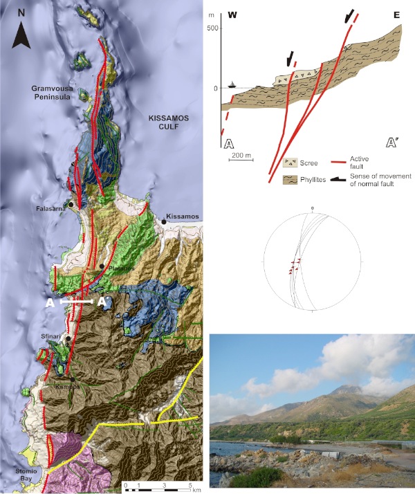
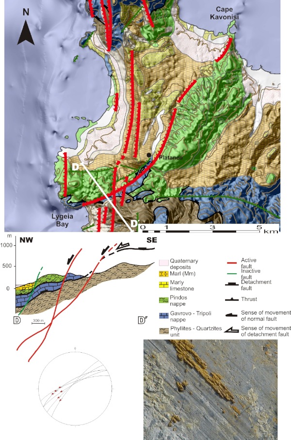
1. The Fault of Western Crete (fig. 12) is a rupture zone of significant length ( > 40km) and a N-S strike, dipping to the West and directly related to D2 tectonics. The fault shapes the western coast of Crete and it is composed of several segments, the most important of which are the Gramvousa (11 km), Falasarna - Sfinari (11 km) and Kampos - Stomion (10 km) segments. These segments cut the basement rocks (the HP/LT phyllite - quartzite unit and limestones of Tripolis and Pindos zones), as well as the Neogene sediments. Moreover, their recent activity affects their own tectonic scree found in older terraces, as well as the erosion materials in more recent terraces.
Figure 12. Neotectonic-geological map and geological cross-section of the Western Crete fault zone
(for map legend see fig. 5). Schmidt diagram (lower hemisphere projection) showing the kinematics of the fault zone, compatible to D2 event. Photo: Western Crete fault affecting tectonic scree of terraces.
All segments are characterized as active faults using geological criteria, such as the influence on recent aeolian sand assemblages in the coastal area, the vertical and curved slopes of streams, the cutting of the recent tectonic scree etc. The present rupture of the fault zone in the terrestrial area represents the initial trace of the fault, thus corresponding to its initial activation. Following this initiation, the tectonic activity was transferred in the sea, hence the active fault zone is located in the sea area, westwards of the present coast line. This is supported be series of historic earthquake epicenters reported by Armijo et al., (1992) for the submarine area in the western coast, with T-axis of E-W strike, a fact that supports the employed geological criteria for its characterization as an active fault. It should be noted that Beneke et al., (2002) have calculated a 0.75 to 1.5 mm/yr uplift rate of the land during Quaternary, due to the tectonic activity of the Western Crete fault zone (fig. 12) .
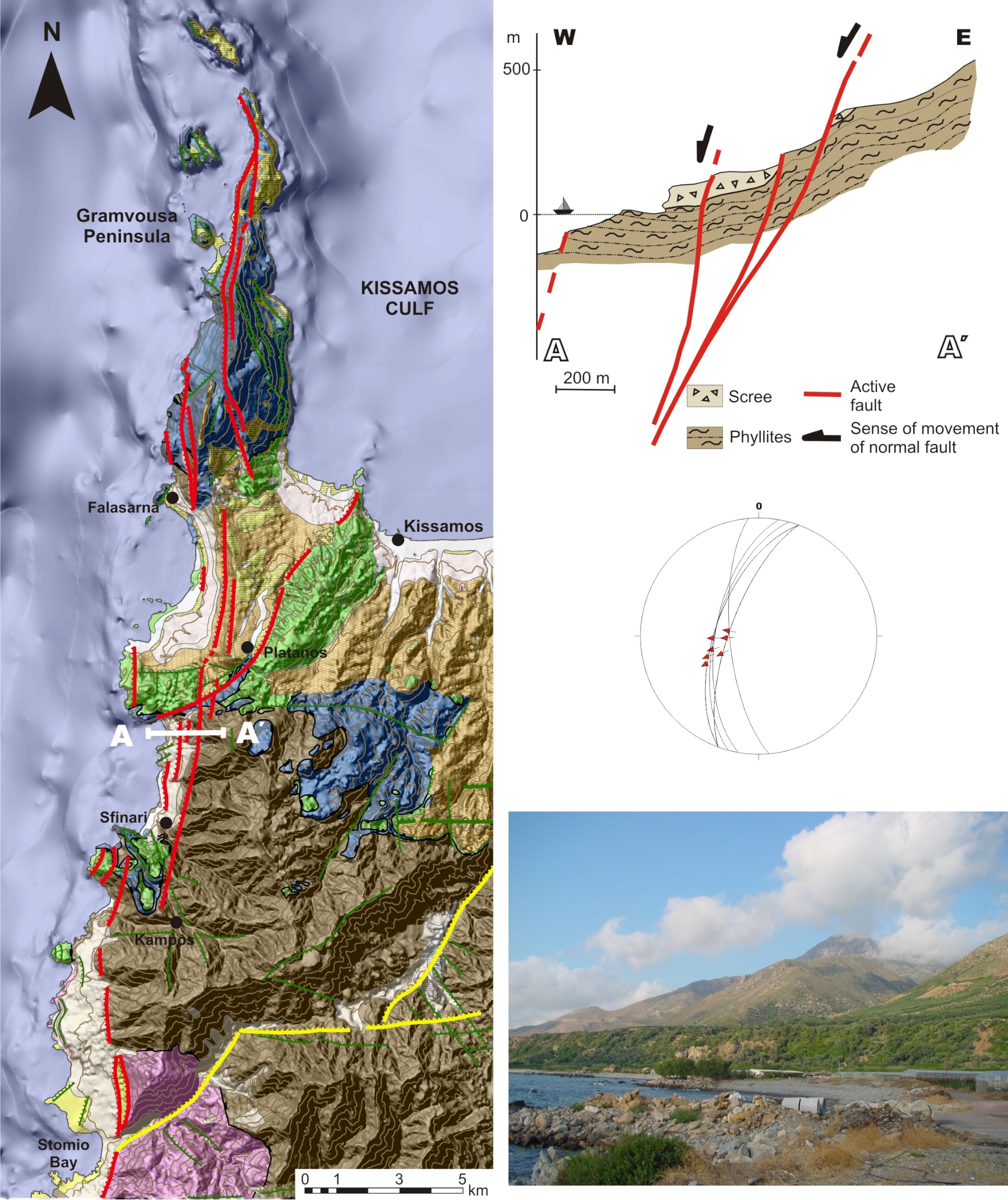
2. The Fault of Malathiros - Rodopos (fig. 13) is also a large (30km) fault zone related to D2 tectonics, trending N-S and also dipping westwards. It’s composed by three main segments, namely the Rodopos (18 km), Kera (4 km) and Malathira (9 km) segments. Several additional fault branches, parallel to the main fault zone, are also identified in the field, as well as antithetic conjugate faults dipping eastwards. The segment of Kera is curved towards the NE and represents a rather dextral transfer fault between the other two segments. Along all segments, especially this of Kera, epicenters of mainly historic surface earthquakes are recorded.
Figure 13. Neotectonic-geological map and geological cross-section of the Malathiros-Rodopos fault zone
(for map legend see fig. 5). Schmidt diagram (lower hemisphere projection) showing the kinematics of the fault zone, compatible to D2 event. Photo: fault plane with striations.
The fault zone cuts many of the Alpine basement rocks, as well as Miocene-Pliocene marl sediments, causing a sharp change of their dipping angle, resulting even in a vertical pattern of their bedding (e.g. in the area of the Malathira village). In some cases, the activity of this fault’s segments is recognized in Pleistocene and younger scree of their rupture surfaces. For these reasons, all segments are considered as active faults with successive tectonic activity regarding the evolution of the fault zone.
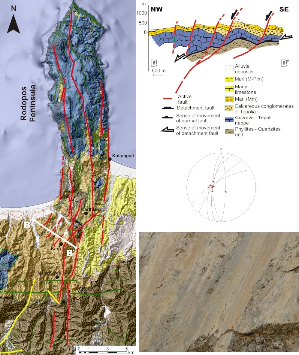
Figure 14. Neotectonic-geological map and geological cross-section of the Kera-Karthiana fault zone

(for map legend see fig. 5). Schmidt diagram (lower hemisphere projection) showing the kinematics of the fault zone, compatible to D2 event. Photo: a. A panoramic view of the fault zone, b. Fault plane with striations.
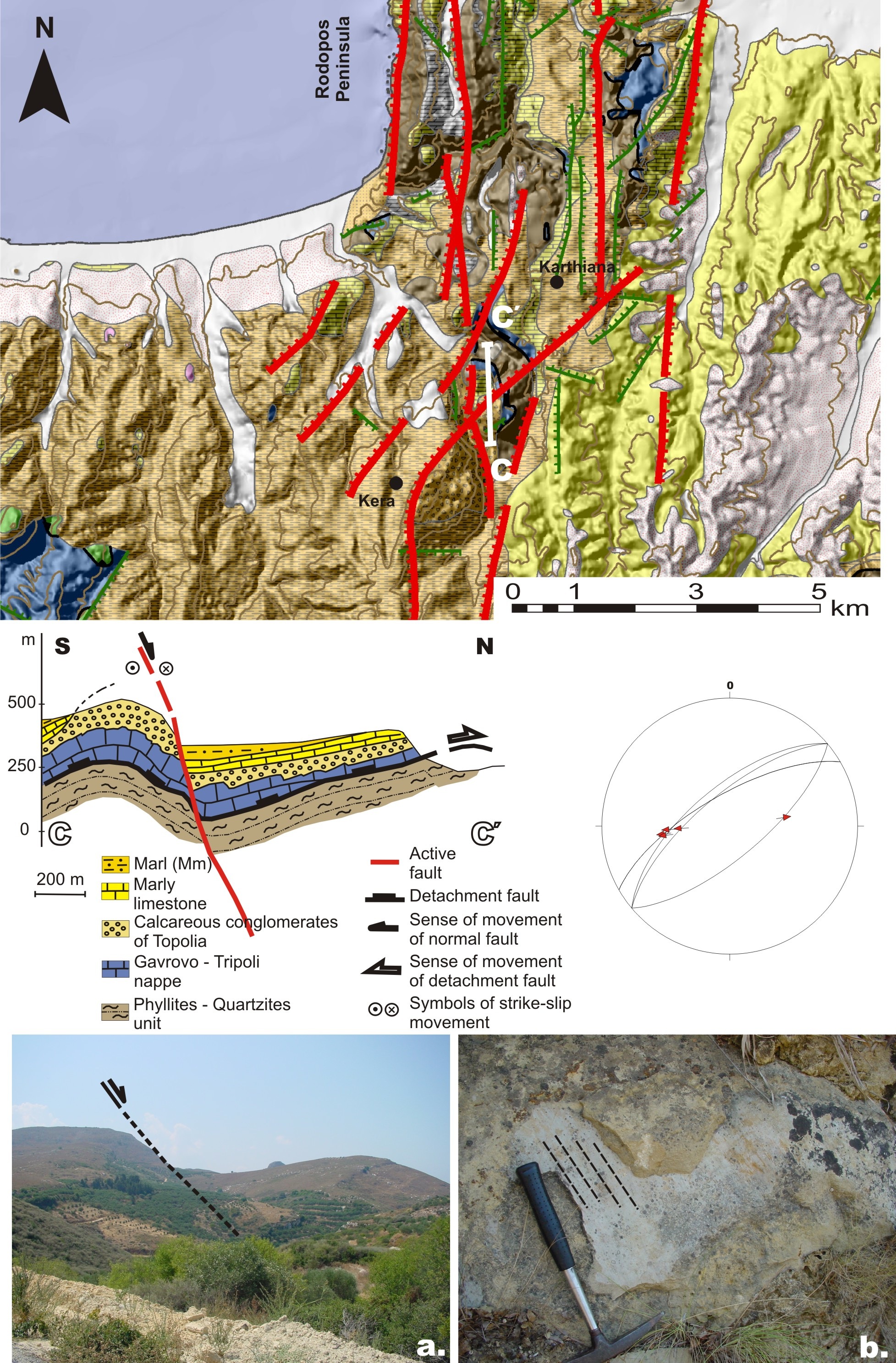
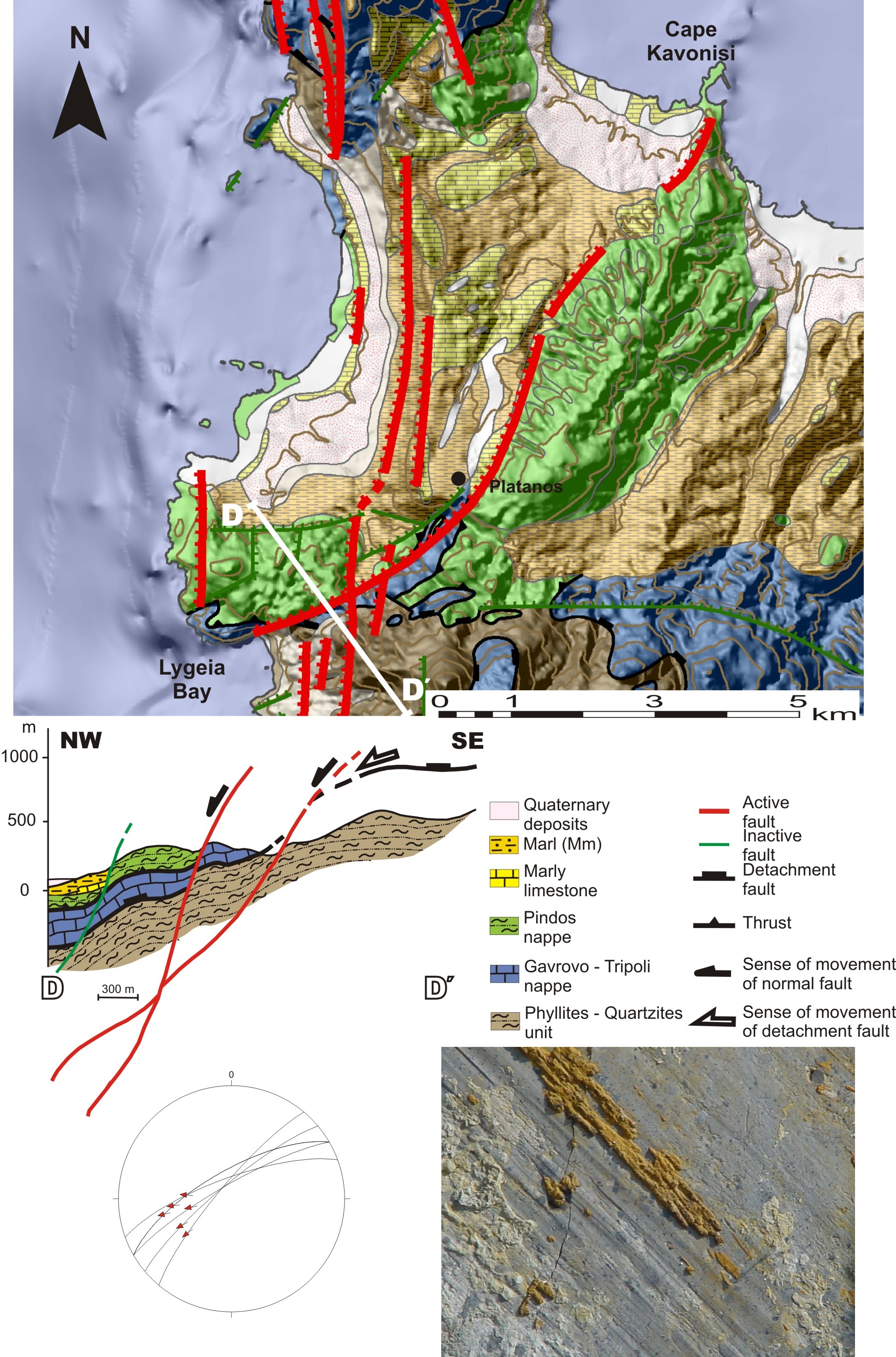
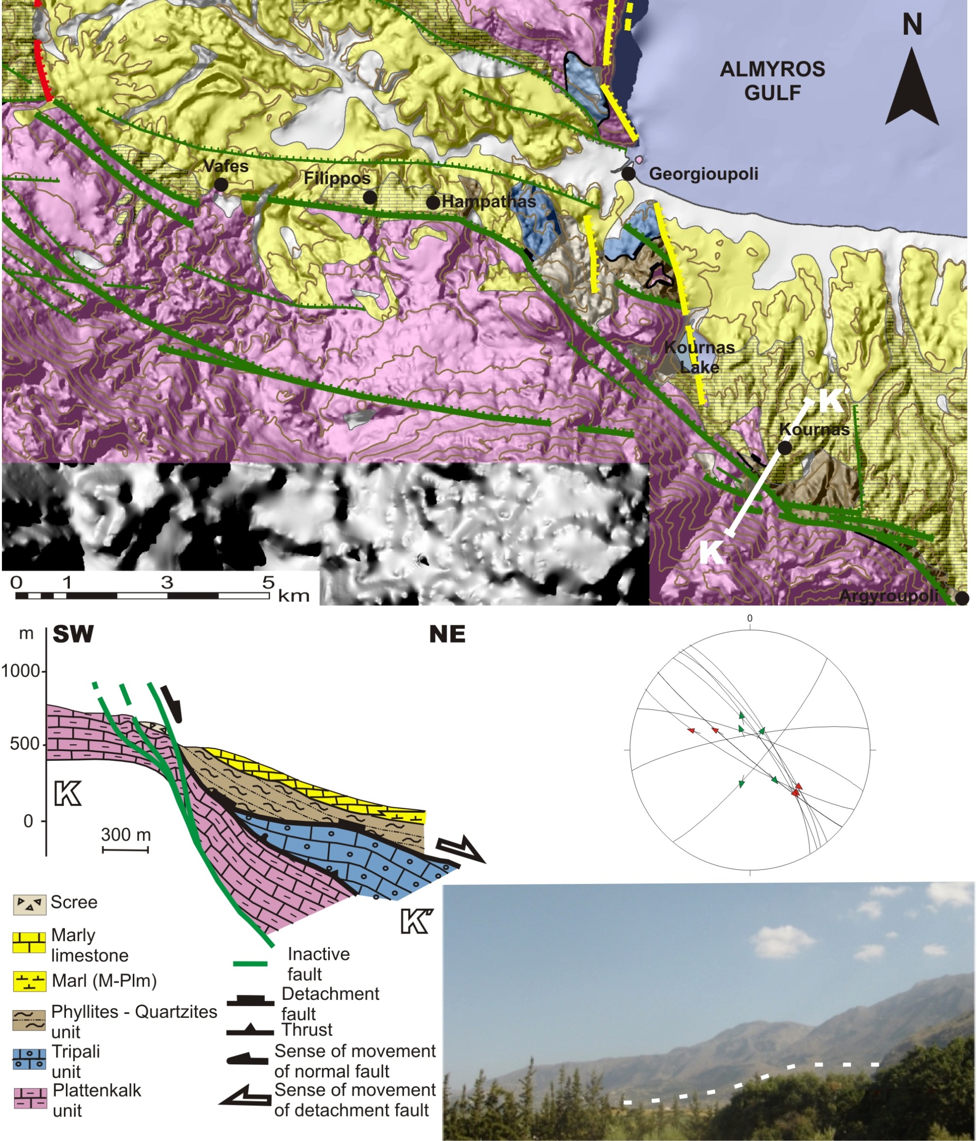
3. The Fault of Kera - Karthiana (fig. 14) was previously described as a transfer active fault between the segments of Malathira - Rodopos fault zone. It has a NE-SW orientation, with a high dipping angle towards the NW and an average length of 4 km, causing an impressive downthrow and tilting of the Neogene sediments. Though it is closely related to the N-S fault of Malathira - Rodopos, it is considered to have a later occurrence or activation, since it influences recent red Pleistocene and scree sediments (fig. 14, 16).
4. The Fault of Platanos (fig. 15) exhibits a NE-SW strike and dips towards the NW. The fault is characterized by an important sinistral horizontal component of motion, related to the D2 tectonics. It clearly overprints the N-S oriented Western Crete fault, thus the Fault of Platanos can be characterized as a lateral-normal active fault (fig. 16).
Figure 15. Neotectonic-geological map and geological cross-section of the Platanos fault zone
(for map legend see fig. 5). Schmidt diagram (lower hemisphere projection) showing the kinematics of the fault zone, compatible to D2 event. Photo: striation on the fault plane with important sinistral strike-slip component.
Figure 16. Photos showing influence of the active faults to Quaternary and recent sediments, as well as interaction between the faults
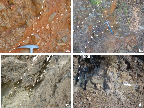
a, b: Influence of Kera - Karthiana fault to Quaternary deposits. c: Influence of Western Crete fault to recent erosion materials. d: Interaction between both active fault zones, those of Platanos (with an important strike-slip component) and Western Crete.
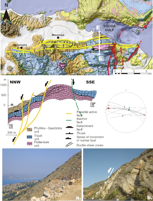
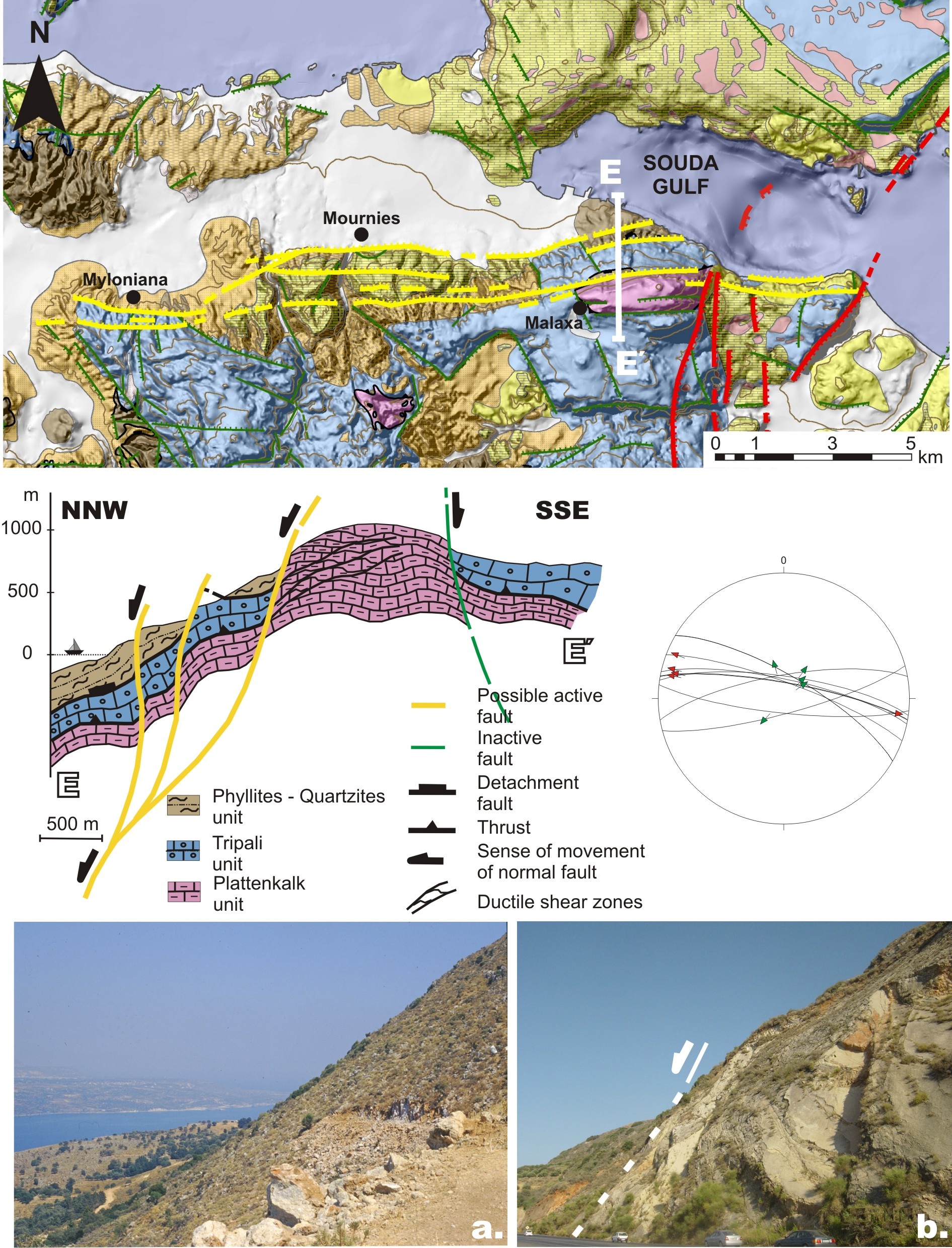
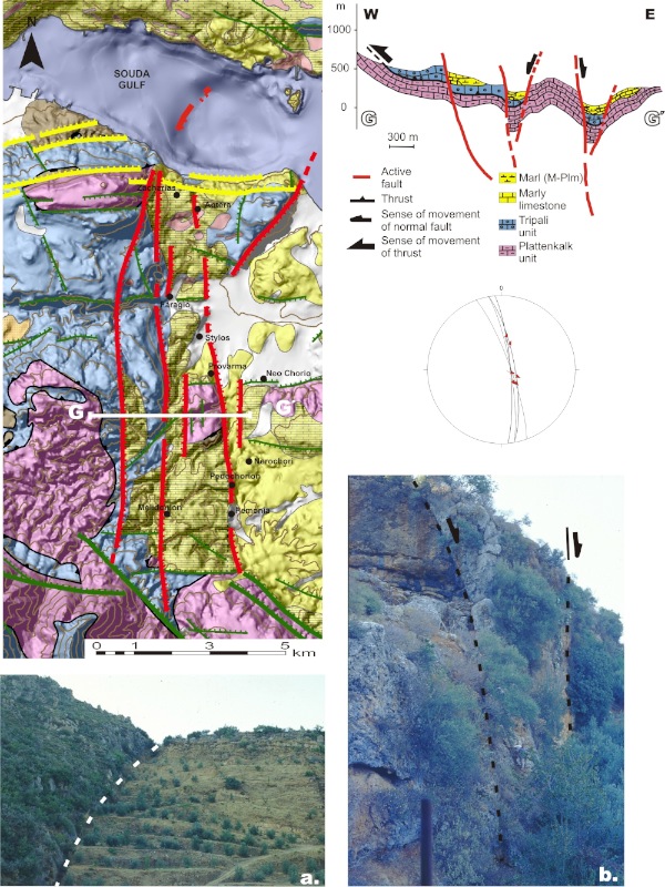
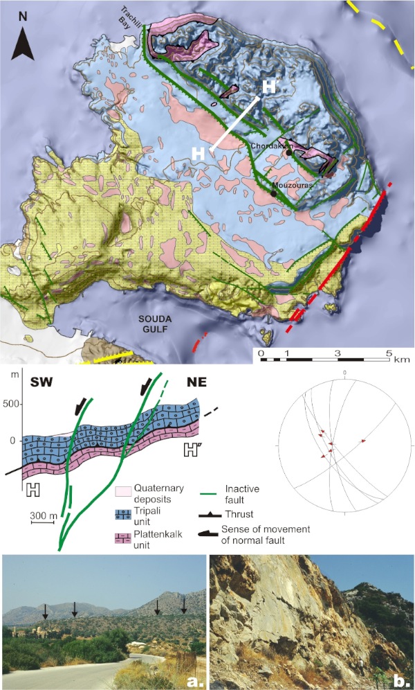
5. The Malaxa - Souda's Gulf Fault (fig. 17) corresponds to a high length ( > 20km) fault zone of E-W strike, dipping towards the North and forming the tectonic graben of Myloniana - Mournies - Souda’s Gulf. The fault zone is composed by a series of parallel fault surfaces, which were formed due to successive fault activity and migration towards the North. Thus, successive tectonic terraces were created, with impressive cataclastite on the Mesozoic Trypali limestone and corresponding gradual subsidence of the tectonic graben. The northernmost and relatively younger branch separates Neogene marls from Pleistocene sediments and causes impressive vertical bedding of the first ones.
Figure 17. Neotectonic-geological map and geological cross-section of the Malaxa - Souda’s Gulf fault zone
(for map legend see fig. 5). Schmidt diagram (lower hemisphere projection) showing the kinematics of the zone, compatible to both D1 (green) and D2 (red) event. Photo: a. The fault zone creating the sharp slope of Souda’s graben, b. Vertical bedding of Miocene - Pliocene marls of Souda’s graben caused by the fault’s activity.
Two main slip patterns were observed on the fault surfaces: The first (older) one is related to an important dip-slip component of motion, clearly linked to the D1 extensional event of Upper Miocene - Lower Pliocene age, when the sharp relief of the Souda’s trough was formed. The second (younger) event is related to a mainly sinistral horizontal component of slip (accompanied by a minor dip-slip component) related to the D2 event and acting from Upper Pliocene-Quaternary up to today. In this sense, the fault zone is considered as possibly active, though its orientation isn’t compatible to the previously described active stress field.
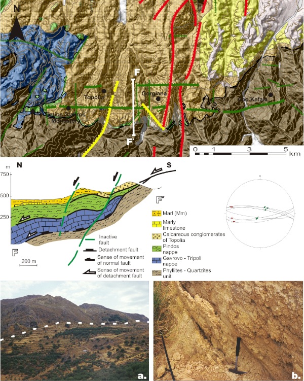
6. The Topolia Fault (fig. 18) represents a fault zone of 10 km length, E-W strike, dipping northwards, related to the D1 extensional event. The Topolia fault evolved as a synsedimentary fault zone related to the initial opening of the Neogene basin of the area during Tortonian. However, on its fault surfaces, younger striations are observed, representing a pure strike-slip motion, compatible to the D2 kinematics. These observations suggest that the fault zone has been reactivated as a strike-slip one during more recent times (Upper Pliocene – Quaternary), showing a similar to the Malaxa - Souda fault evolution.
Figure 18. Neotectonic-geological map and geological cross-section of the Topolia fault zone
(for map legend see fig. 5). Schmidt diagram (lower hemisphere projection) showing the kinematics of the fault zone, compatible to both D1 (green) and D2 (red) event. Photo: a. Panoramic view of the fault, b. Offset structures along the fault, related to the D2 activity.
7. The Zacharias - Pemonia Fault (fig. 19) is a large fault zone in the western part of the Neogene basin of Apokoron. This fault has a N-S strike and a gradual step-like fall towards the East through a system of parallel fault branches, involving a total length of 11km. This fault system affects the Neogene sediments and forms the Apokoron basin by successive tectonic terraces, impressive slickensides, cataclastic phenomena and surface openings. Its kinematics are compatible to the active stress field, hence it is characterized as an active fault zone.
Figure 19. Neotectonic-geological map and geological cross-section of the Zacharias - Pemonia fault zone
(for map legend see fig. 5). Schmidt diagram (lower hemisphere projection) showing the kinematics of the fault zone, compatible to D2 event. Photo: a. A segment of Zacharias - Pemonia active fault zone displaying surface opening, b. Cataclastic zone along Zacharias - Pemonia fault.
8. The Akrotiri Fault (fig. 20) develops in a NW-SE strike, dipping in a high-angle towards the SW. It is composed by parallel faults in a characteristic “doublex” structure, forming tectonic terraces and the large plateau of Akrotiri, with a total observable length of 11km. Although its orientation is not compatible to the active stress field, the kinematics and geometry of the fault indicate that it was activated during D2 event, as on its fault plane an oblique downwards sense of slip is recognized by the observed striations and other kinematic indicators.
Figure 20. Neotectonic-geological map and geological cross-section of the Akrotiri fault zone
(for map legend see fig. 5). Schmidt diagram (lower hemisphere projection) showing the kinematics of the fault zone, compatible to D2 event. Photo: a. Tectonic terrace created by the fault activity, b. Fault plane of Akrotiri fault with oblique striations.
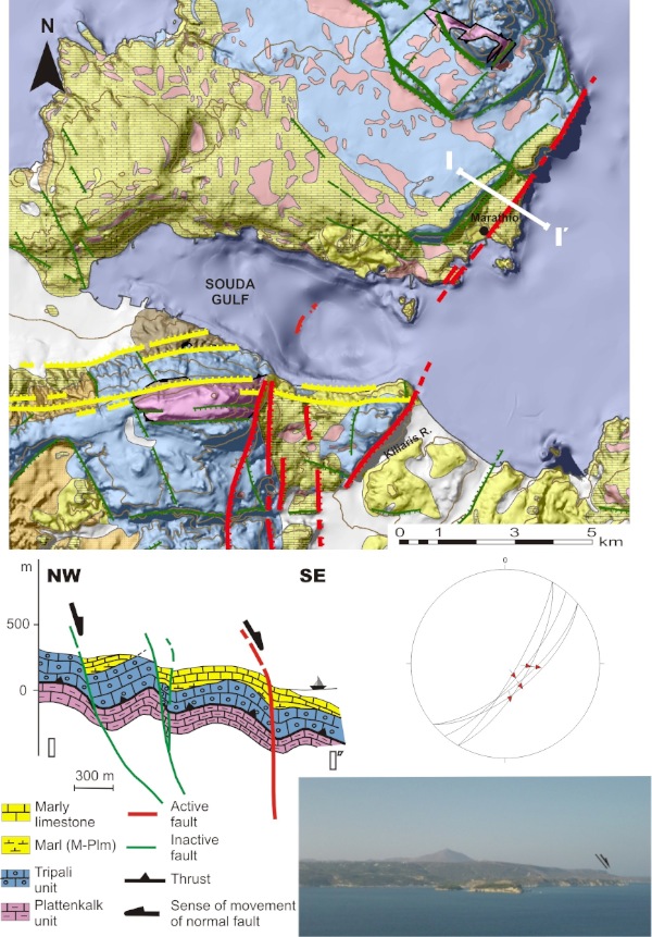
9. The Fault of Marathi (fig. 21) develops along the SE edge of the Akrotiri Peninsula, forming its high-angle dipping slopes. The fault trends NE-SW, dipping in a high angle towards the SE. Its continuation beyond Souda’s Gulf is also recognized in the Ancient Aptera archaeological site. Apart of the basement rocks, the fault intersects the last Pleistocene terrace of Akrotiri fault, showing that the Marathi fault is clearly younger. The kinematics and geometry of the fault are compatible to the D2 event and it is considered to have a recent Quaternary activity.
Figure 21. Neotectonic-geological map and geological cross-section of the Marathi fault zone
(for map legend see fig. 5). Schmidt diagram (lower hemisphere projection) showing the kinematics of the fault zone, compatible to D2 event. Photo: a panoramic view of the fault.
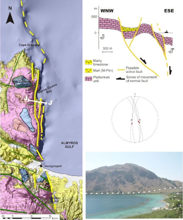
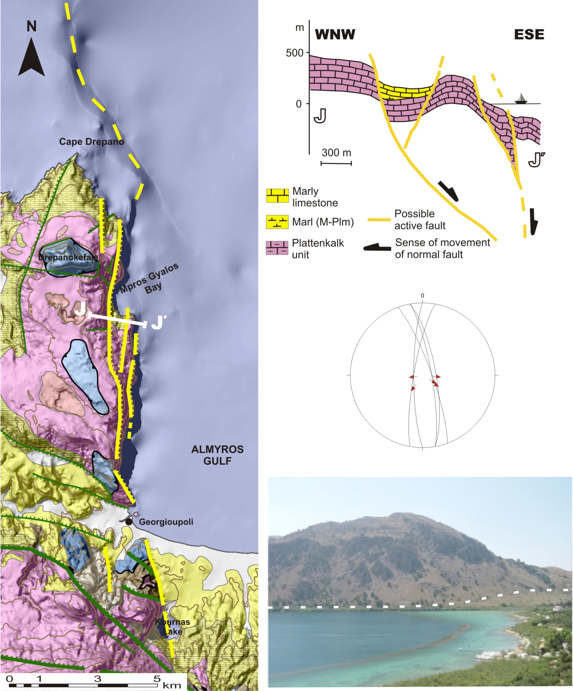
10. The Drepanokefala - Georgioupoli Fault (fig. 22) corresponds to a group of parallel faults between Drepano Cape and Georgioupoli, of a total length of 15km, trending N-S and dipping at a high-angle to the East. The kinematic and dynamic profile of the fault coincides with the observed pattern of the other large N-S trending faults, hence it was considered to belong to the D2 event, and characterized as possibly active.
Figure 22. Neotectonic-geological map and geological cross-section of the Drepanokefala - Georgioupoli fault zone
(for map legend see fig. 5). Schmidt diagram (lower hemisphere projection) showing the kinematics of Drepanokefala - Georgioupoli fault zone, compatible to D2 event. Photo: A panoramic view of the fault, along the western coast of Kournas Lake.
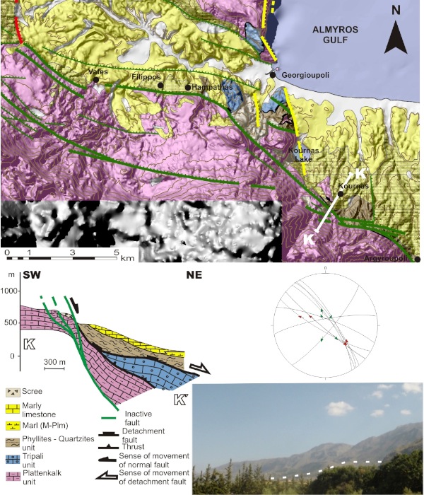
11. The Fault of Argiroupoli - Kournas - Habathas (fig. 23) is a large fault zone of NW-SE strike and dipping towards the NE, acting as a boundary fault between the basement and the homonymous Neogene basin. It is composed by several spatially distributed segments, with a total length of 20km. Though the fault development is not compatible with the active stress field, two slip patterns were observed on its rupture surfaces, namely an initial ca. dip-slip one (D1 event), followed by a second lateral to horizontal one, indicating the fault’s reactivation during D2 event of Upper Pliocene – Quaternary age.
Figure 23. Neotectonic-geological map and geological cross-section of the Argiroupoli - Kournas - Habathas fault zone
(for map legend see fig. 5). Schmidt diagram (lower hemisphere projection) showing the kinematics of the fault zone, compatible to both D1 (green) and D2 (red) event. Photo: A panoramic view of the fault.
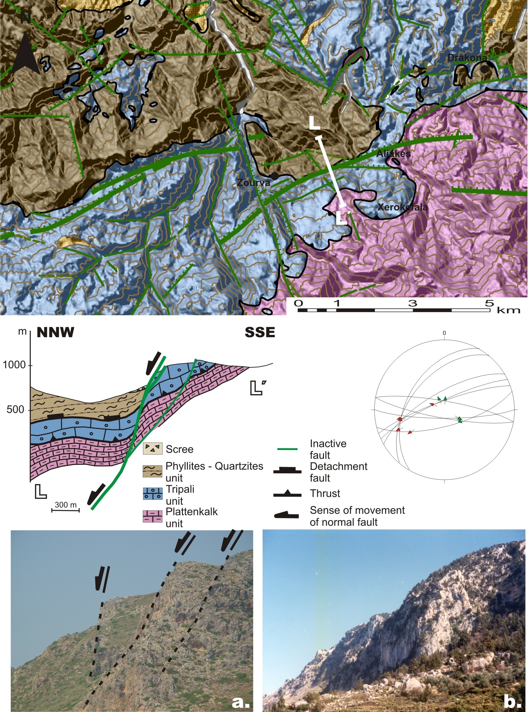
12. The Fault of Zourva (fig. 24) represents a fault line of significant length, which crosses the whole western Crete (Chania) area, reaching up to the Rethymnon region. The fault is clearly observable also in satellite images, having a roughly E-W strike and a high-angle dip to the North. The fault is clearly related to the Miocene extensional detachment of the nappes, but has been also activated during both the D1 event, with an important dip-slip component of motion towards the North, as well as during the recent D2 event, showing an important strike-slip component and a lateral sinistral sense of shear.
Figure 24. Neotectonic-geological map and geological cross-section of the Zourva fault zone

(for map legend see fig. 5). Schmidt diagram (lower hemisphere projection) showing the kinematics of the fault zone, compatible to both D1 (green) and D2 (red) event. Photo: a. Normal duplex structures along Zourva fault zone, b. High-angle fault plane of Zourva fault.
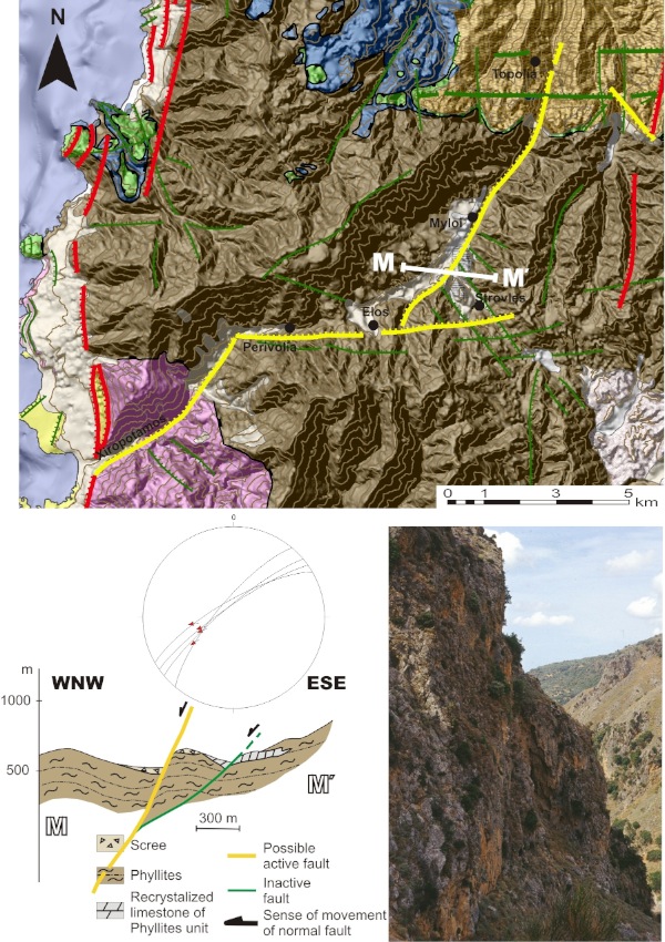
13. The Fault of Xiropotamos - Elos - Myloi (fig. 25) is a fault zone of NE-SW strike, dipping towards the NW. The fault is composed of three continuous segments, with a length of 8.5km, 4km and 5.5km, respectively. It mainly crosses basement rocks along the Xiropotamos stream, but also forms Pleistocene tectonic scree along its trace. The kinematics and dynamics of the fault are in accordance with the D2 event, with a main dip-slip normal and minor horizontal sinistral component. The compatibility with the recent (active) stress field, as well as the presence of small magnitude seismicity along the fault line, suggest that this fault can also be characterized as possible active.
Figure 25. Neotectonic-geological map and geological cross-section of the Xiropotamos - Elos - Myloi fault zone
(for map legend see fig. 5). Schmidt diagram (lower hemisphere projection) showing the kinematics of the fault zone, compatible to D2 event. Photo: A fault plane of a segment of Xiropotamos - Elos - Myloi fault zone with an impressive cataclastite.