VIII. GEOARCHAEOLOGY OF MT. LYKAION SANCTUARY
VIII-A. Concept of a Geoarchaeological Column
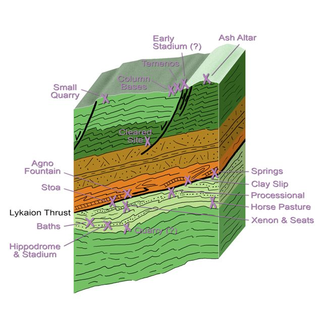
How are the archaeological elements of the Sanctuary of Zeus generally related to the geology? To this end I have constructed what I call a “geoarchaeological column,” which here displays the positioning of the Sanctuary of Zeus archaeological elements in relation to rock formations, stratigraphic contacts, geologic structures, and bedding orientation(s) (Figure 44). The companion illustration (Figure 45) is my “geoarchaeological map,” which displays the placement of the archaeological elements on a simplified version of the geological base map. Explicit in the geoarchaeological column is the thrust-fault repetition of stratigraphic formations, and thus the distinction of the Lykaion thrust sheet (above) and the Hippodrome thrust sheet (below). Affixed to the geoarchaeological column are the geologic positions of each of the archaeological elements.
Figure 44. Geoarchaeological column.

"Geoarchaeological column” showing the locations of the archaeological elements with respect to stratigraphy and structure. See text for details.
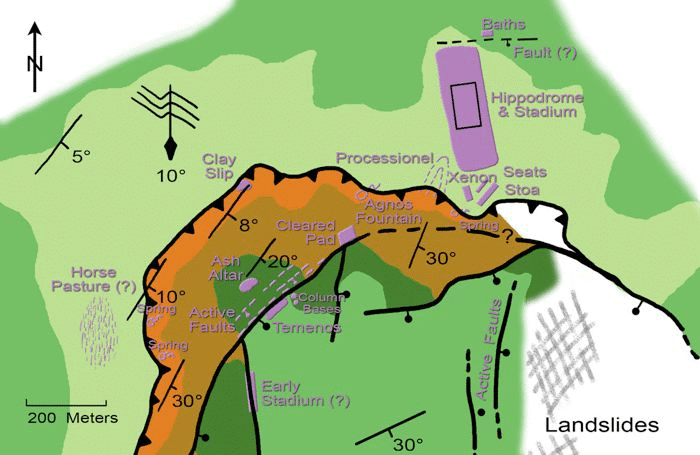
Figure 45. Geoarchaeological map.
“Geoarchaeological map” showing the locations and (in some cases the) shapes of the archaeological elements with respect to the mapped geology. See text for details.
VIII-B. Archaeological Elements in the Lower Part of the Sanctuary
The archaeological elements of the lower part of the Sanctuary of Zeus reside in the uppermost part of the Pan thrust sheet. They are found exclusively in association with Transitional Flysch Beds and the Lykaion thrust fault proper. The major features are the hippodrome, stadium, bath, processional way, stoa, xenon, seating, and springs (see Figures 44 and 45).
The hippodrome, stadium, and bath occur within a flat expanse of landscape that coincides closely with the stratigraphic contact between Thick White Limestone Beds (below) and Flysch Transition Beds (above). The contact at this location is very gently dipping, nearly horizontal. The hippodrome surface is buried beneath a colluvial cover (no more than several meters thick), which is composed of sand and silt derived from weathering and erosion of the flank of Mt. Lykaion. It is likely that such a soft mantle of colluvium had developed in this flat expanse well before human occupation, and that the combination of the flatness and soil was a ‘natural’ for selecting this site for a hippodrome and stadium. The stone blocks of the bath complex are exclusively limestone from the Thick White Limestone Beds. The source and pathway of water that fed the baths is not yet clear, and is currently under study.
The processional way is a ridge that rises gently toward Mt. Lykaion from the southwestern corner of the hippodrome (see Figures 44 and 45). It appears to have been a pathway up the mountain. Underlying bedrock is Flysch Transition Beds. The ridge itself is one of the geomorphic corrugations so typical of weathering and erosion of Flysch Transition Beds.
The stoa, xenon, and seating lies just beneath the trace of the Lykaion thrust fault, in the uppermost part of the Pan thrust sheet (see Figures 44 and 45). All of these structures are built of limestone from the Thick White Limestone Beds. The foundation for these structures varies, in places Flysch Transition Beds bedrock, in other places colluvium. The stoa is closest to the trace of the thrust. Its foundation is locally anchored in limestone bedrock. Immediately above is the thrust and highly sheared Chert Series Beds of the Zeus thrust sheet. The sheared, faulted, crushed bedrock could have been easily ‘swept’ aside as needed during construction of the upper parts of the stoa.
Springs occur in the lower sanctuary, as well as along the western base of the St. Elijah klippe. Not unexpectedly, they emerge from the fault zone, where sheared Chert Series Beds creates a largely impermeable barrier to downward flow of groundwater within the Lykaion klippe. The remains of fountain houses and statues (e.g., statue bases) are made exclusively from limestone from the Thick White Limestone Beds.
VIII-C. Archaeological Elements in the Upper Part of the Sanctuary
The archaeological elements of the upper part of the Sanctuary of Zeus are found at the very top of the St. Elijah klippe. The major features are a stadium (?), temenos, and ash altar. These are portrayed at the top of the geoarchaeological column and geoarchaeological map (see Figures 44 and 45). Each of these is located either in the Thin Platy Limestone Beds or Thick White Limestone Beds. Furthermore, these elements are arranged in a small, local area marked by active normal faulting.
The soft level grassy patch (~100 m X 15 m) along the trace of the Grassline fault near the top of the mountain may have been the site of a very ancient stadium in the upper sanctuary area (David Romano, personal communication, 2004). Fracturing and crushing of bedrock along this fault zone undoubtedly contributed to deeper weathering and erosion along this stretch, and the development of this grassy topographic depression.
The temenos also occupies a flat patch of ground (~60m NE/SW and ~20m NW/SE), and is located on the shoulder of the very summit of Mt. Lykaion (see Figures 44 and 45). As has been noted, Its northwestern margin is close to the trace of the Temenos active normal fault. The flatness of the temenos fundamentally reflects the presence of a bedrock-supported structural terrace where bedding attitudes are horizontal to very gently dipping. The bedrock exposed from place to place within the temenos appears to be the thin-bedded stratigraphic transition between Thick White Limestone Beds (above) and Thin Platy Limestone Beds (below), composed of alternating layers of limestone and mudstone. The easy splitting property of this bedded interval must have been the main control for the weathering and erosion that, in this case, created a kind of natural pavement.
Bedrock supporting the summit of Mt. Lykaion at the site of the ash altar is Thin Platy Limestone Beds (see Figures 44 and 45), and its poor exposure reflects the ease with which the highly jointed, thin-bedded limestone becomes weathered and eroded. The smooth, colluvium-coated summit creates a soft and smooth form on the top of which the ash altar was created. The scree bands on the side of the ash altar hill are almost certainly the traces of active faults, such as the Altar fault.