Natural hazard factors related to the interplay between geology and anthropical evolution
The geological setting of an area does not just influence the development of its urban settlements by providing geomaterials for the construction of the cities. It also sets the conditions in which the interaction between natural and anthropic dynamics can be disturbed by numerous factors of risk. Apart from the obvious effects of volcanic and seismic activity (by far the most hazardous elements of risk - both continuously monitored by the Italian Civil Protection; see http://www.protezionecivile.it/), two main factors controlling and threatening the environmental and anthropic evolution of the Neapolitan area are represented by landslides and underground cavities.
Landslides
Landslides have had a significant impact on the territorial evolution and safety in the Phlegrean district since historical times. In fact, the earliest evidence which can be related to a slope instability was found in the ancient centre of Naples, in the archaeological site under the San Lorenzo church. Here, 7 m below the present-day ground level, the Imperial age (1st century A.D.) city market is partly buried under a chaotic deposit ascribed to a flood that occurred at the end of 5th century (TCI, 2001), and which probably moved down the slopes of the Caponapoli hill, the northernmost edge of the first Greek-Roman town (5th century B.C.).
In recent years, thorough archival and bibliographic research has allowed reconstruction of the historical landslide activity of the Phlegrean area (Calcaterra et al., 2002d, 2003b), since the 19th century.
In Naples, the worst reported event occurred in 1868: on February 28th, a huge volume of NYT fell from Mt. Echia (a small hill overhanging the Chiaia district) reaching, after a travel of some hundred metres, the Castel dell’Ovo and blocking the whole area for several days. On that occasion, 60 people died and tens of injuries were registered. Another event which deserves to be mentioned took place towards the end of the 19th century. A rockfall in NYT detached along the coast of Posillipo, near the Donn’Anna Palace, on New Year’s Eve of 1889. A further landslide was registered in the same area on January 11 1889, after which authorities decided to remove some unstable blocks from the cliff by shelling them from the sea. The “remedial measures” went on from January 21 to February 2, when 200 m3 of tuff fell down the hill, hitting a building (Lenci Palace) and causing serious damages.
In Pozzuoli, the earliest archival information dates back to the 19th century. An English newspaper of that time reported that a rockfall occurred along the coast of Pozzuoli as a consequence of an earthquake which hit the area on October 12, 1856, even though no record was found in the official catalogues which probably indicates that the mass movement was caused by a local low-energy seism (Calcaterra et al., 2003b).
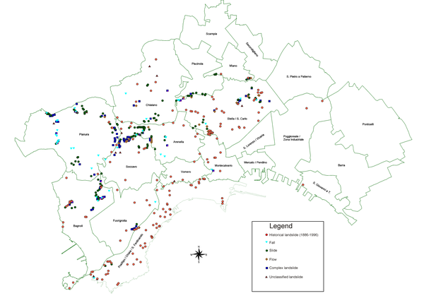
Figure 66. Landslides in Naples.
Landslides distribution in the city of Naples [after Calcaterra et al. (2002d), modified].
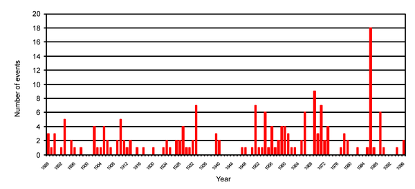
Figure 67. Landslides in Naples.
Annual distribution of the landslides in the city of Naples for the period 1886-1996 [after Calcaterra et al. (2002d), modified].
Figure 68. Landslides in the Campi Flegrei.
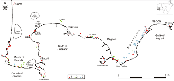
Coastal landslides of the continental Campi Flegrei district [after Calcaterra et al. (2003b), modified]. 1) Fall; 2) slide, slide-flow; 3) unclassified landslide.
As a result of the historical research on Naples, 192 landslides were identified in the time span 1886-1996, distributed over the municipal territory as shown in Figure 66, while the temporal distribution is depicted in Figure 67. The main peak corresponds to 1986, due to a major rainfall-induced episode which occurred in February and which caused a high number of mass movements in the whole of the Phlegrean area (see also Beneduce et al., 1988). On the other hand, the total absence of data in years such as 1914, 1916, 1918, 1941-1946 can be explained with the presumable loss of attention paid during wartime by the media to events of local interest. In 109 cases, triggering causes were tentatively identified: rainfall events caused about 60% of landslides, 15% of which were also affected by human activity. The latter - considered alone as a triggering factor and subdivided in trenching/excavation and quarrying activity - was responsible for the remaining 40% of mass movements. Thanks mainly to articles and accompanying photographs, typology of landslides was recognized in 58% of cases. A large part of them were rockfalls; soil slide-debris flows in loose pyroclastics were identified in a limited number of cases, most of which came from Beneduce et al. (1988). NYT was easily recognized as involved in 69 mass movements, the remaining being ascribed to loose pyroclastics. In this case, no further distinction was made, since terminology employed by many of the sources were not clear enough. In any case, the youngest pyroclastic deposits clearly have hosted a large number of events (including top-soil and landfills). Even if information is scarce regarding the volumes of material mobilized, much more detail can be found to account for property damage and human casualties caused by landslides. Roads, private houses, retaining walls, and vehicles are the typical elements involved in a huge number of landslides. Eighty of them caused deaths or serious injuries to people. In total, 191 human lives were lost in Naples by mass movements, and some hundreds of injuries were counted.
Figure 69. Landslides in the Campi Flegrei.
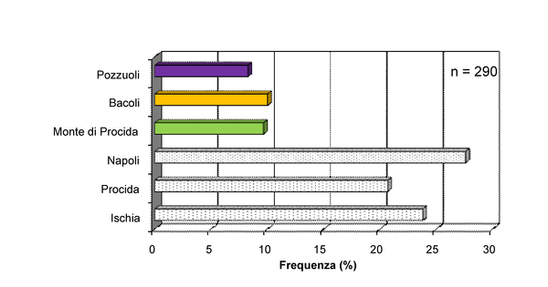
Frequency distribution of coastal landslides over the Campi Flegrei territory [after Calcaterra et al. (2003b), modified].
The research on historical landslides has been extended to the shoreline of the Phlegrean district, including both the continental sector and the islands of Ischia and Procida (Fig. 68; Calcaterra et al. 2003b). As regards the Phlegrean municipalities located west of Naples (Pozzuoli, Monte di Procida, Bacoli), 80 events were inventoried, dated between 19th century and 2001 (Fig. 69). Falls detached from the Yellow Tuffs and slide-flows in the youngest loose pyroclastic deposits are the prevailing typologies which have repeatedly affected the road connections along the Phlegrean coast, sometimes resulting in serious consequences. This was the case of a rockfall that occurred on November 1970 in Pozzuoli when a couple of blocks, 10-12 ton in weight each, landed on a Naples street, killing two people.
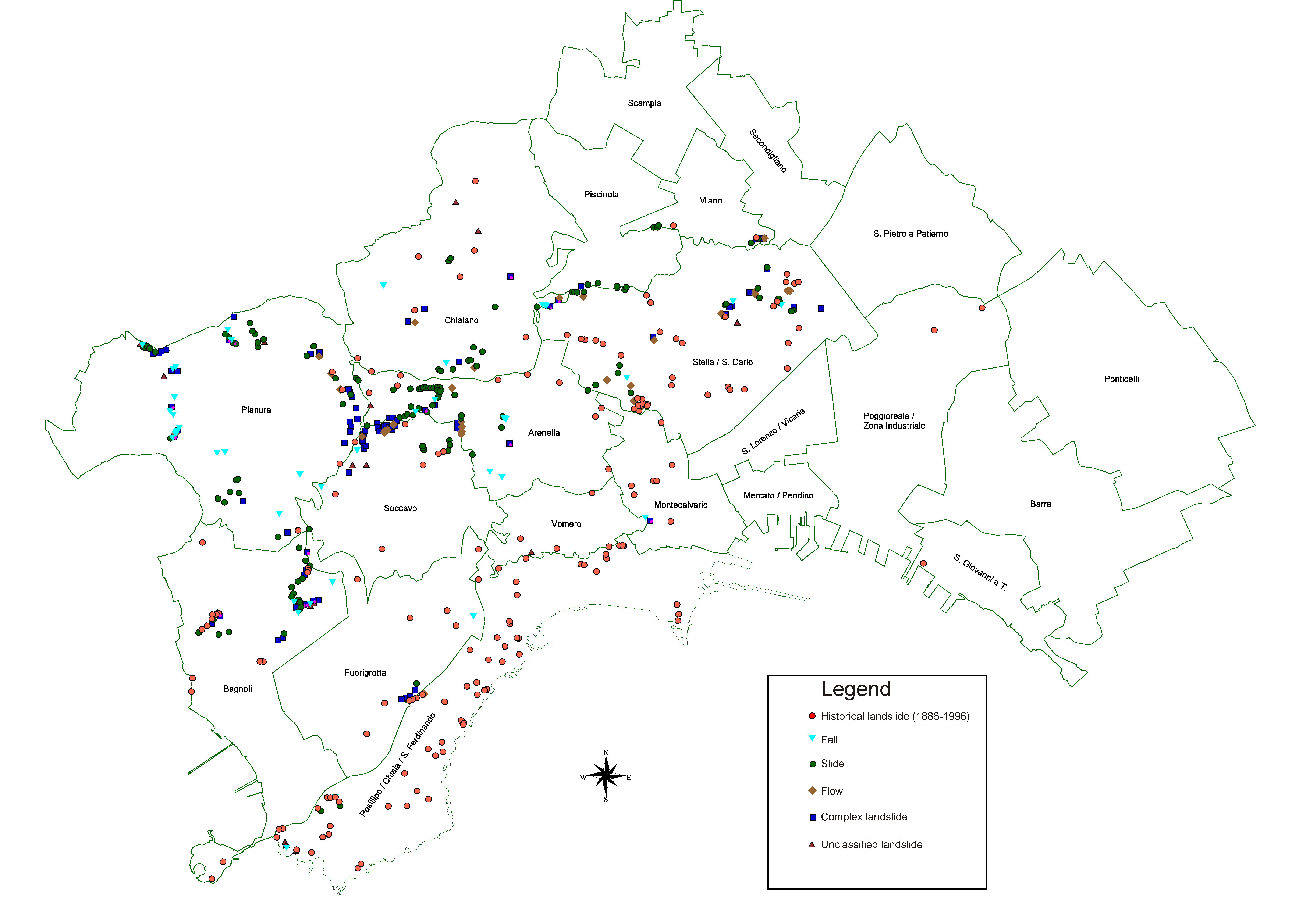
Figure 70. Landslides in Naples.
Temporal landslide distribution in the city of Naples. 1) Borough of Posillipo; 2) borough of Stella-S. Carlo all’Arena; 3) borough of Pianura; 4) borough of Soccavo.
Notwithstanding the long history of Phlegrean slope instability, the turning point in public awareness of the threat was represented by the regional geomorphic crises which hit the Campania region from 1996 to 1998. The worst of all these events was the one which involved Sarno and four other towns in the carbonate Apennine (160 victims). In Naples and in the Phlegrean municipalities, a huge cluster of landslides took place in the 1996-1997 winter, with an absolute peak on January 10-11, 1997. Calcaterra and Guarino (1999a, b) described the basic features of that event at Naples, when more than 300 shallow landslides, mostly of the soil slide-debris flow type, involved essentially the loose pyroclastics younger than 15 ka, causing severe damages to man-made structures. Comparing the historical data available for Naples with those commented by Calcaterra and Guarino (1999a, b), it can be highlighted that landslide distribution shows a sort of “migration” from some districts to other ones: if in the past Posillipo and Stella-S. Carlo were more frequently involved in slope instabilities (Fig. 70), during the January 1997 event the highest number of landslides was registered along the slope of the Camaldoli hill, falling for a great part within the districts of Pianura and Soccavo. Provided that most of these phenomena were induced by rainfall, the tentative explanation of the cited migration could relate more to human impact on slope stability. At Posillipo, in fact, in the period up to the start of WWII, important infrastructure and buildings were being constructed. Furthermore, most of the NYT urban quarries were open within the boundaries of Stella and Posillipo. Dell’Erba (1923) mentions about 25 sites where NYT exploitation was active in both districts. On the contrary, the Camaldoli hill was extensively involved in urbanization in second half of the 20th century.
Figure 71. Landslides in Naples.
Location of the main landslides occurred on the north-western (Pianura) and south-eastern (Soccavo) sides of Camaldoli Hill between 1996 and 2006 [after Calcaterra et al. (2007a), modified].
The incidence of Camaldoli landslides, compared with the total number of events in Naples has substantially increased in recent times. In fact, between 1868-1996 only 15 of the inventoried landslides involved the Camaldoli slopes, while, from 1996 to August 2006, about 150 mass movements were identified along the Camaldoli slopes (Fig. 71) of a total number of about 400 mass movements recognized in the same period at Naples. Among the recent landslides, slides are the prevailing typology, as simple movement or as initial component of complex events, which evolve into debris flows; such landslides primarily involve the post-NYT loose pyroclastic terrains. Falls detached from lithified tuffs are also typical of the Camaldoli slopes, which can again trigger flow-like movements. The majority of Camaldoli landslides, as well as in the whole Neapolitan territory, do not exceed 1 m in depth. Slope angles in the source areas vary widely. Whilst falls move as usual from slopes with angles greater than 60°, in the case of the slide and flow types the highest number of events (69%) occur at values between 30° and 55° (mean value: 45°), with an overall frequency pattern which shows a Gaussian distribution.
Along the flanks of Mt. Somma-Vesuvius, the main slope instability type is represented by floods. In this respect, it is interesting to note that local populations refer to these events as lave (lava flows), which clearly reflects their high mobility and destructive action. In volcanic regions, a certain confusion persists when mass flows involving pyroclastic deposits have to be defined. The most popular term is probably “lahar”, an Indonesian word that describes a hot or cold mixture of water and rock fragments flowing down the slopes of a volcano and (or) river valleys (http://volcanoes.usgs.gov/hazards/lahar/index.php). However, scientists often use more specific terminology to describe properties and behaviour of lahars, for example: mudflows, debris flows, hyperconcentrated flows, cohesive and non-cohesive flows. The worst Vesuvian lahars followed the A.D. 79 and the December 1631 eruptions. In more recent times, the products ejected during the April 1906 eruption fed a number of slope instabilities, especially along the western side of the volcanic edifice, which caused serious damage to the towns of Pollena Trocchia, Cercola and S. Anastasia (Mercalli, 1906; AA.VV., 1999; Carlino, 2001).
Underground cavities
The presence of underground cavities in urban areas can have serious consequences for man-made structures, sometimes leading to their sudden collapse. In the Phlegrean district, this has been the case since the first evidence of human presence and activity, which goes back to about 4500 yrs. B.C. In fact, one of the oldest archaeological findings is a couple of Neolithic underground tombs (the so-called “Gaudo culture”) discovered in 1950 in the Materdei district, Naples, which were carved in the NYT (Albertini et al., 1988).
The expansion of the first communities, which started in the 5th-4th centuries B.C., was accompanied by an increasing demand for building materials, but also for underground spaces. Catacombs, conduits, aqueducts, cisterns, food and beverage repositories have been continuously dug in the subsoil of the Phlegrean towns through the centuries. During World War II, the same caverns (more than 200) were used as air raid shelters, while in more recent times some of them have been further adapted (parking garages, warehouses, illegal waste disposal sites, even a theatre-cinema) and nowadays represent one of the main tourist attractions all over the district (Fig. 11b).
A few years ago, the Naples provincial government carried out a survey of all the province's municipalities (with the exception of Naples) which revealed that the subsoil of 39 municipalities (out of 92) is characterized by the presence of underground cavities (Provincia di Napoli, 2002). 1965 cavities have been inventoried, 881 of which have been directly surveyed, showing an area of about 254,000 m2 and a volume of about 1,400,000 m3. All three Phlegrean towns west of Naples (Pozzuoli, Bacoli, Monte di Procida) are populated with underground openings; however, only 31 cavities are known, most of which are of archaeological interest.
On the contrary, Naples is the capital of the province as regards the cavities, as well. In fact, no fewer than 500 underground openings are known in an area covering about 620,000 m2 (Albertini et al., 1988). The most interesting of them is probably represented by the network of conduits, pits and cisterns created for the Roman aqueduct, which brought water via the Aqua Augusta, historically referred to as the Serino aqueduct; its source was in the Terminio-Tuoro massif, located some 60 km east of Naples. Several kinds of instabilities affected the Neapolitan underground voids, which have been described by Evangelista (1994). One of the most common is settling (or occasional collapse) of the ground surface above the cavity vault caused by excessive upward propagation of the quarrying activity. Even though unrelated to the specific geological setting, underground fires are also a significant problem in Naples due to the dumping of tons of waste and garbage into the voids below in recent years; such a situation has caused several fires which have burned out of control, sometimes with tragic consequences.
If NYT is the main formation affected by the cavities in Naples, some of the greatest underground openings in the city were dug in the Piperno formation which, as recalled above, represents the most widely used stone in the historical architecture of Naples. Piperno was exploited from Greek-Roman times until the beginning of the 20th century when the environmental conditions became very dangerous. One of the ancient underground quarries has been recently studied in detail (Calcaterra et al., 2007a, b), which included a topographical study of the site (Fig. 32a). The surveyed quarry covers an area of about 5,000 m2. As a whole, its development does not show any predefined exploitation scheme or any preferential direction. In addition, pillars are scattered over the area without any logical distribution, showing irregular and different shapes - evidently an indication of static fatigue causing cut off rock prisms to topple to the floor (Fig. 32b).