Data and 3D geological modeling: background
Data
In the last few decades, many new techniques of digital data collection and management have been developed in the Earth Sciences. Existing digital geological databases (e.g. National geologic map 1:50,000 - CARG Project) are being continually updated and a variety of new specialized databases are being created in the framework of institutional activities or national research projects (e.g. Deep Crust Exploration Project – CROP, Visibility of petroleum exploration data in Italy - ViDEPI, DPC-INGV Seismological Projects).
This vast amount of data needs to be managed, shared and disseminated to support the requests of a wider range of end-users.
The Geological Survey of Italy (SGI) institutionally collects, maintains and provides access to some of the national geological databases, including:
1. the national geologic cartography database at 1:25,000 scale, developed from the survey of new national geologic map at a scale of 1:50,000 (CARG Project). This database is harmonized, although the geologic surveys are executed from various regional geological surveys, thanks to the elaboration of guidelines and the standardization process carried out from the SGI (www.apat.gov.it/Media/carg/index.html and http://serviziogeologico.apat.it/Portal/ptk);
2. the database of wells more than 30 meters deep and tunnels more than 200 meters long (according to the Italian Law 464/84). This dataset contains information on approximately 75,000 wells, generally including stratigraphic, and/or geophysical and piezometric data;
3. gravity anomaly data measured at more than 358,000 stations on Italian territory (http://www.apat.gov.it/site/en-GB/Projects/Digital_ Gravity_Maps_of_Italy/default.html)
4. geodetic data (GPS network).
Moreover, the SGI sponsored the publication of the CROP Atlas (Scrocca et al., 2003) which contains all the crustal seismic reflection profiles acquired during the Italian deep crust exploration project (CROP Project).
3D geological modeling
The widespread use of three-dimensional modeling softwares, capable of processing and displaying large quantities of different surface and subsurface geological data, allows the user to view and interact with these data analyzing the precise and complete relationships among them. These powerful tools make it possible to build 3D geological models and representations, constructed from all the available data (among many others, de Kemp, 2000; De Donatis, 2001; Dhont et al., 2005; Fernandez et al., 2004; Fernandez, 2005; Fernandez et al., 2009) optimizing the use of these geological datasets.
Furthermore, the use of 3D software helps geologists evaluate and visualize critical areas in three-dimensions. Using 3D data effectively, geologists can produce a more rigorous and comprehensive geological model and they can check data consistency, understanding the spatial relationships among structural or stratigraphic features.
Lacking ready access to these databases and to the tools to utilize them, 3D representation and modeling currently are little used in academia and in the public authorities. Nevertheless in the last decades, in order to fulfill their institutional and scientific missions, some National Geological Surveys (e.g., Bureau de Recherches Géologiques et Minières – BRGM France, British Geological Survey, Geoscience Australia) have promoted projects aimed at the 3D data visualization and reconstruction of regional to detailed 3D models (http://www.bgs.ac.uk/science/3dmodelling/home.html; http://www.ga.gov.au/map/web3d/; Calcagno et al., 2004a; Calcagno et al., 2004b; Strzerynski et al., 2005).
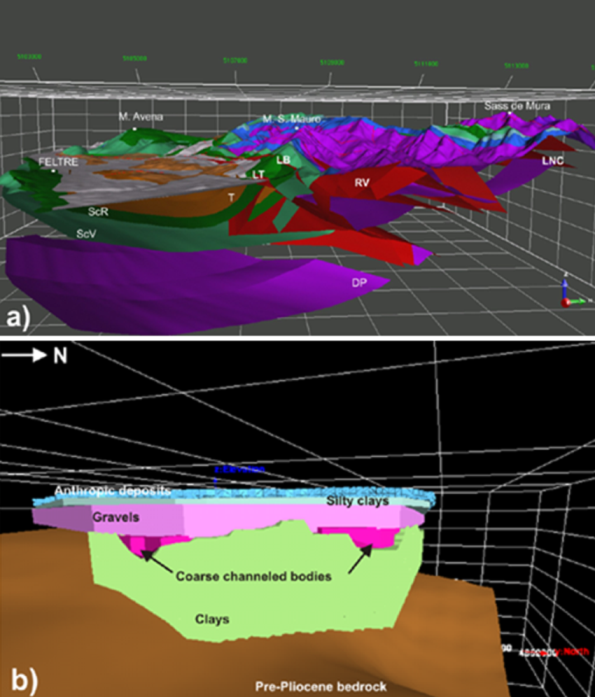
Since 2000, the SGI has expanded its institutional activities promoting projects aimed at the use of three-dimensional geological models to interpret and display surface and subsurface data available, first of all, in the CARG database. The three-dimensional modeling techniques have been applied to a variety of geological areas, at various scales, to achieve different purposes (Table 1). The results were 3D geological models (Figure 1 and Video “3D geological models”) (De Donatis et al., 2002; D’Ambrogi et al., 2004; Fantozzi, 2004; Araneo et al., 2004; D’Ambrogi & Doglioni, 2008; D’Ambrogi & Ricci, 2008) derived from, and controlled by, detailed field and well data stored in SGI databases.
Table 1. Characteristics of 3D geological models
| 3Dmodels | Geological domain | Area (km2) | Depth (m) | Data input - surface | Data input - subsurface | Purpose |
|---|---|---|---|---|---|---|
| Fossombrone | Northern Apennines | 600 | 3.500 | Field data (1:10,000) Attitude data | Cross-sections Well stratigraphies Seismic profiles | 3D representation geological sheet |
| Firenze | Alluvial Plain | 25 | 100 | Cross-sections Well stratigraphies Bedrock isobaths map | Analysis of rock volumes | |
| Polino | Central Apennines | 18 | 400 | Field data (1:10,000) | Cross-sections | Paleogeographic reconstruction |
| Cimini | Volcanic area | 250 | 3.000 | Field data (1:10,000) | Well stratigraphies Bedrock isobaths map | Hydrogeological complexes |
| Fiumicino | Deltaic area | 80 | 100 | Field data (1:10,000) | Well stratigraphies | 3D representation subsoil geological sheet |
| Vette Feltrine | Southern Alps | 300 | 2.500 | Field data (1:10,000) Attitude data | Cross-sections | Structural restoration |
One of the main achievements of this activity is to optimize the use of primary geological observations from field survey and geological maps, as a source for 3D models. The workflow for detailed 3D reconstructions is based on data correlation performed by the geologist; the time and effort involved in this activity could act as a disincentive, but the final result is a more comprehensive model of geological bodies and structures, useful also to support decisions related to environmental issues, land use and engineering applications.