Analysis of intermediate to short-term displacement within individual crustal segments
The altitude of LIg and Holocene markers varies along the coastline of Italy, and this occurrence stems from different sources including regional and local tectonic processes, hydro-isostatic adjustments to deglaciation, sediment constipation, and, for the more recent times, from anthropogenic causes. In the following, the rates established on the elevation of the LIg and Holocene markers are outlined in specific sectors, which are selected on the basis of the known past and ongoing crustal deformation processes. Analysis of the spatial and temporal variability of displacement rates along these crustal sectors is carried with the aim of placing constraints on different tectonic contributions to coastline displacement. Because the present paper is intended as a national review, in the following paragraphs the primary straightforward interpretations for individual situations are illustrated along with data presentation, whose detailed discussion is presented in the quoted analytical publications. A short summary is attached at the end of each paragraph. In the later Discussion section, an interpretation of the emerging pattern is illustrated at a broader scale blending together geological and instrumental data.
Sardinia margins.
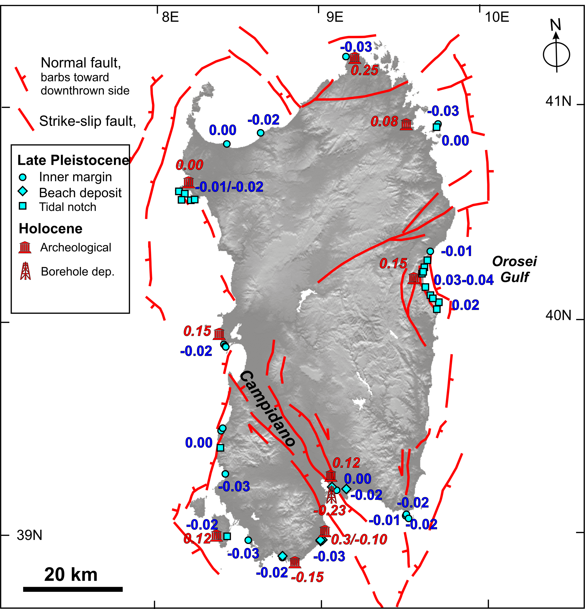
From Sardinia, an extensive number (58) of LIg sites are known (Fig. 3), where the marker elevation has the lowest variability among the nation coastline of between 2-10 m, and therefore it was chosen as reference site for the LIg eustatic elevation (Ferranti et al., 2006; Lambeck et al., 2004; in press). Within this generally stable setting, minor but consistent patterns of vertical motions at metre scale were detected. Extremely slow subsidence occurs on the NW (Ferranti et al., 2006), indicative of block motion possibly accommodated by fault creeping or sliding associated with the Ligurian continental margin. In the central segment of the eastern coast (Orosei Gulf, Fig. 3), uplift of the LIg marker at a comparably low rate forms a bulge which has been associated with upward welling of magma in the nearby offshore (Ferranti et al., 2006; Mariani et al., 2009).
Archaeological markers (numbering 12) of between 2.5 and 1.6 Kyr BP indicate Late Holocene stability or weak uplift (0.1–0.25 mm/yr) at several locations along the coast (Antonioli et al., 2007). A core recovered near the town of Cagliari shows Holocene subsidence at an average rate of 0.23 mm/yr (Lambeck et al., in press, and references therein), which, given the pattern of nearby sites (Fig. 3), is likely due to sediment compaction. In general, it appears that Holocene rates are slightly higher than LIg data and predominantly positive (Fig. 3), perhaps due to the larger uncertainty in estimating paleo-shoreline from archaeological markers.
All in all, LIg and Holocene data in Sardinia reveals a general stability with only localized coastal tectonic motions. Given the robust control provided by the LIg marker, it is possible to isolate the different, very localized contributions of block sliding (or fault creeping) in the north, sediment compaction in the south, and volcanic bulging in the east.
Figure 3. Vertical displacement rates in Sardinia.
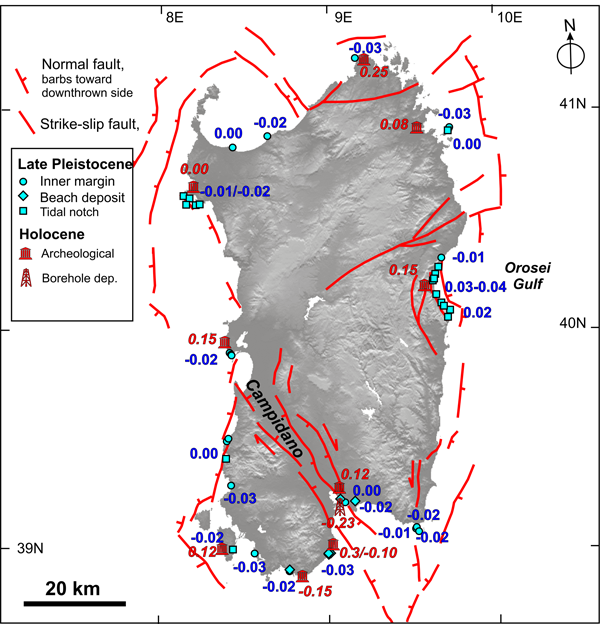
Vertical displacement rates (mm/yr) computed from the elevation of Late Pleistocene and Holocene markers plotted with main faults on a DEM of Sardinia (slightly modified after Ferranti et al., 2006).
Ligurian Sea margin
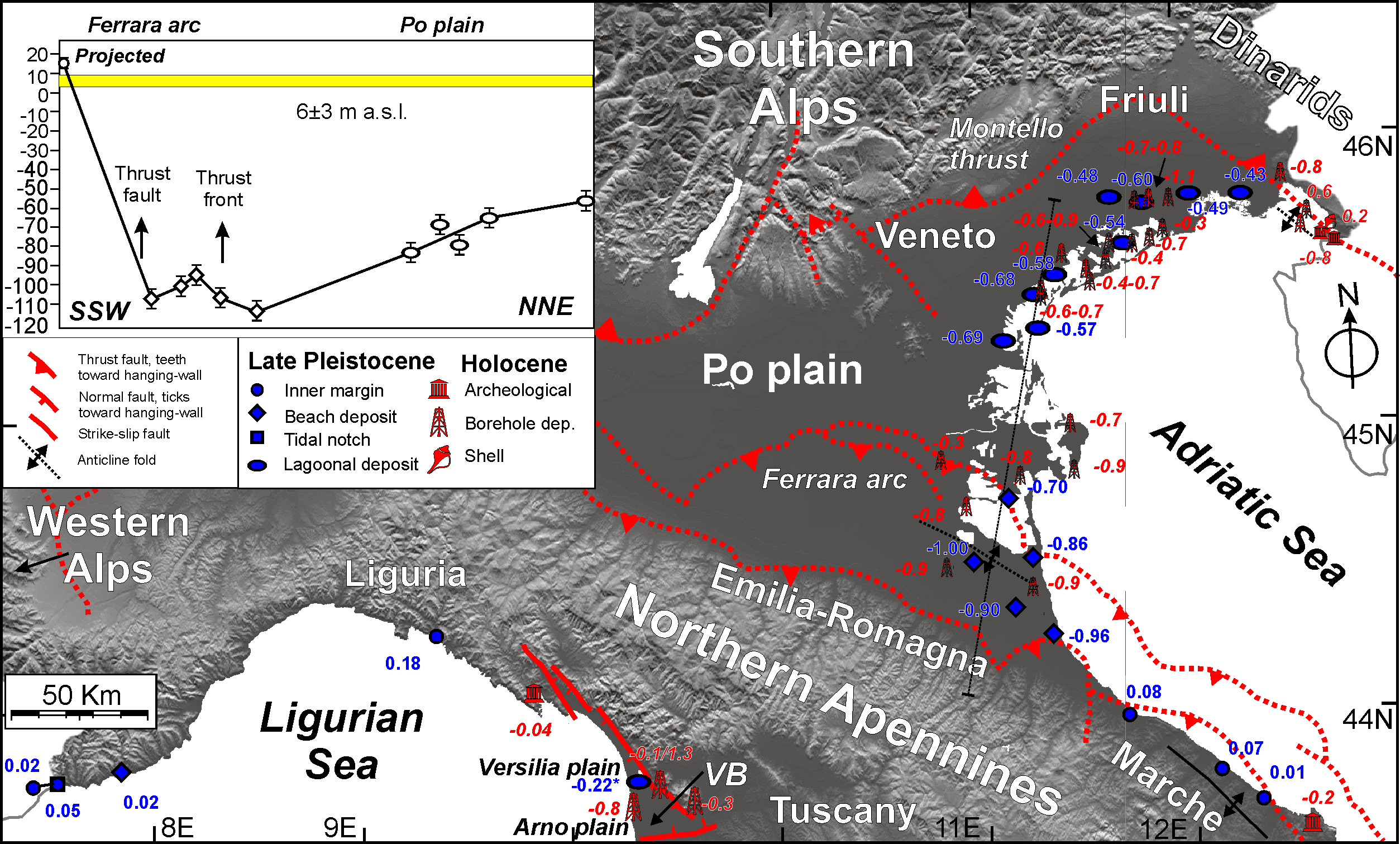
The Liguria region margin features a rugged topography with coastal ranges limited by sheer cliffs (Fig. 4), but large recent displacements are not present. The little information (5 sites) available from the LIg marker indicates mild uplift of the eastern coast at ~0.2 mm/yr (Federici and Pappalardo, 2006), and an almost stable western coast (Roveri et al., in press). Likewise, a geoarcheological indicator in eastern Liguria suggests almost negligible subsidence at 0.04 mm/yr (Antonioli et al., 2009).
It is known that the eastern Liguria Apennines experienced Quaternary surface uplift at 1 mm/yr (Bernini and Papani, 2002), and seismicity documents that extension is still active in the east (Fig. 2). However, coastal markers indicate that the margin to the west is quiet.
Figure 4. Vertical displacement rates in northern Italy.
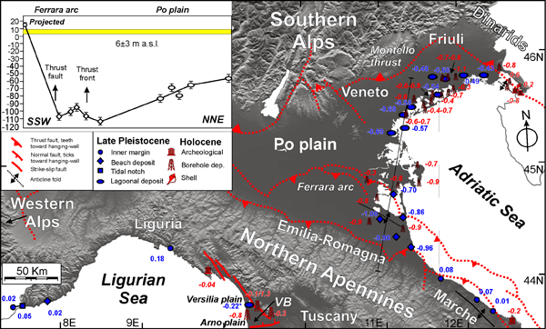
Vertical displacement rates (mm/yr) computed from the elevation of Late Pleistocene and Holocene markers plotted with main thrust faults and folds on a DEM of northern Italy. Rate value with asterisk in Tuscany is established on pre-Lig strata in borehole. VB=Viareggio basin. Inset shows section of Lig marker elevation across the front and foredeep of the Northern Apennines (trace indicated by thin solid line) (slightly modified after Ferranti et al., 2006).
Eastern Tyrrhenian Sea margin, northern sector.
The Tyrrhenian Sea margin stretching from the administrative regions of Tuscany in the north and northern Calabria in the south, is characterized by the the alternation of coastal promontories and plains, shaped by extensional faults that have caused horizontal displacements both orthogonal and parallel to the margin (Mariani and Prato, 1988; Ferranti et al 1996; Acocella and Funiciello, 2006).
In northern Tuscany, the Viareggio half-graben basin (Argnani et al., 1997) and ancillary basins in the interior (Fig. 4) are bordered by normal faults whose activity shifted in space during Late Neogene, and also tuned the Quaternary subsidence pattern (Aguzzi et al., 2007). Geophysical explorations indicate that the recent-most activity was segregated along the southern border of the basin, which is limited by a NE-SW striking fault (Cantini et al., 2001) (Fig. 4).
A very mild subsidence (0.25 mm/yr; Fig. 4) of the northern part of the basin (Versilia coastal plain) during the last 200 kyr is documented from borehole data (Antonioli et al., 2009), and thus LIg to Holocene stability was supposed at the same location (Lambeck et al., 2004; in press). In the south (Arno river plain: Aguzzi et al., 2007), borehole data analysis (Fig. 4; Lambeck et al., in press) yields Holocene subsidence at rates ranging from ~0.2-0.3 (core CC, in the interior) to ~0.8 mm/yr (core M1, near the coastline), the latter being comparable to the long-term value in the same core (Antonioli et al., 2009).
Figure 5. Vertical displacement rates in central Italy.
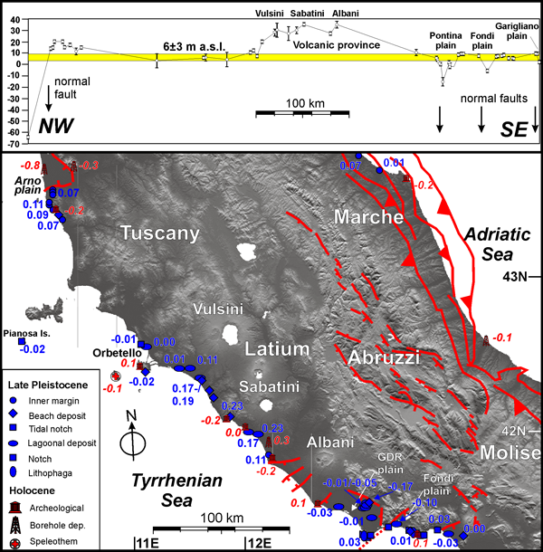
Vertical displacement rates (mm/yr) computed from the elevation of Late Pleistocene and Holocene markers plotted with main faults on a DEM of central Italy. GDR=Giuliano di Roma. Inset shows coast-parallel section of Lig marker elevation on the Tyrrhenian coast (slightly modified after Ferranti et al., 2006).
It is thus reassessed that recent subsidence in the south may stem from focused activity on the border fault outlined by gravity anomalies and alignment of moderate-size earthquake epicenters (Cantini et al., 2001). Post-100 kyr BP activity of this fault was previously supposed based on the elevation of the LIg marker just to the south of the basin, where it was uplifted to 15-20 m a.s.l. before tailing to a background value further to the south (Fig. 5). Uplift at up to ~0.1 mm/yr was related to flexural unloading in the footwall of the bordering fault (Ferranti et al., 2006). Flexural models (King et al., 1988) predict that the subsidence-to-uplift ratio along normal faults, although locally varying as a function of integrated co- and post-seismic slips, and of the thickness and thermo-mechanical behaviour of the brittle layer and lower crustal flow induced by sediment load redistribution, is typically in the order of 3. Thus, a ~0.3 mm/yr subsidence in the Arno plain could have been predicted on the basis of the tectonic displacement experienced by the footwall crest. Based on this, it is further inferred that the site having this subsidence value (core CC) shows a true tectonic signal, whereas the core with higher subsidence (M1) may reflect an additional component, likely deriving by its estuarine, constipation-prone location (Fig. 5).
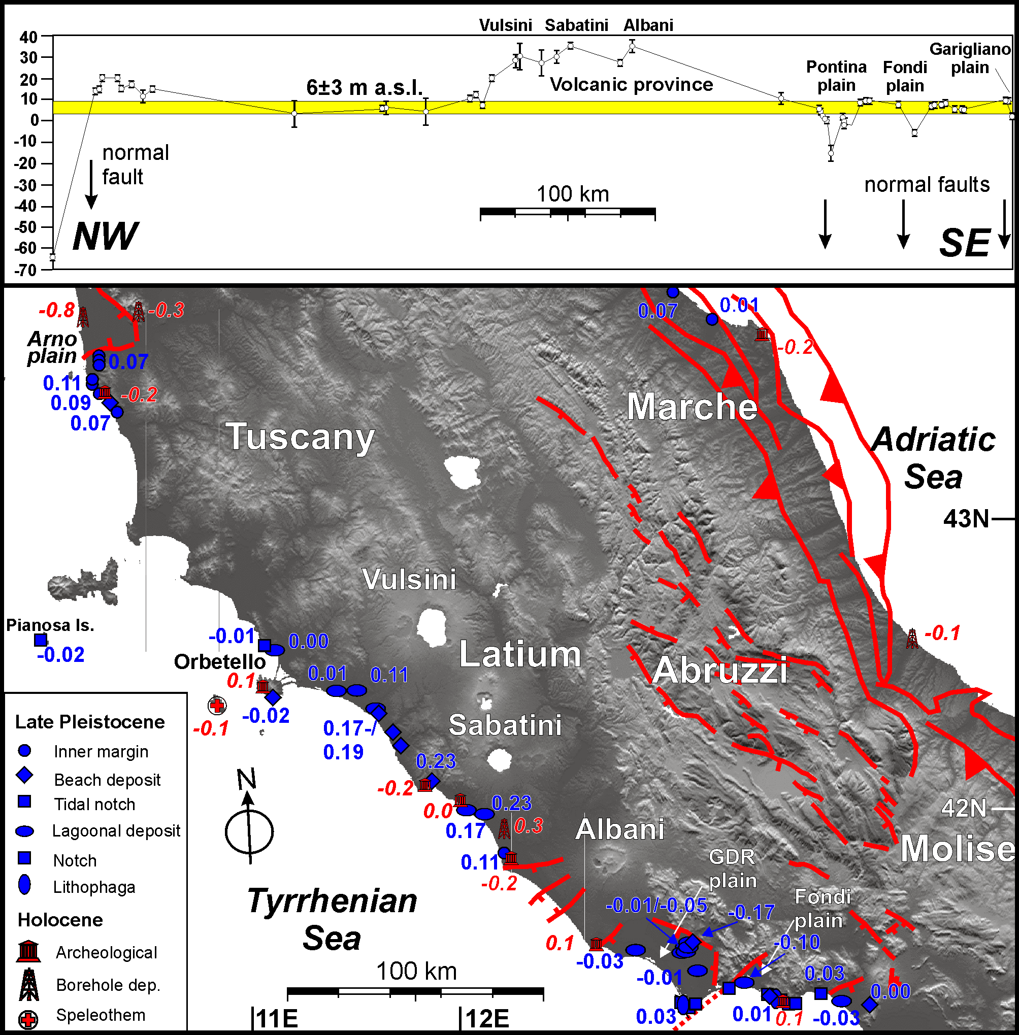
The central part of the margin between central Latium and Campania regions is characterized by a Quaternary volcanic province whose activity has been progressively shifting southward in time (Barberi et al., 1994). Appraisal of the marker elevation (Bordoni and Valensise, 1998; Ferranti et al., 2006) is consistent with the volcanological observation. Specifically, whereas in southern Tuscany and northern Latium (near the Orbetello promontory and at Pianosa island, Fig. 5) intermediate- and short-term markers suggest stability or a extremely slow subsidence, from the Sabatini to the Albani volcanic complex the LIg marker forms a 150 km-wavelength bulge at 0.1-0.2 mm/yr related to magmatic injection beneath the 420 kyr vents (Bordoni and Valensise, 1998; Karner et al., 2001; Nisi et al., 2003), and with spikes deriving by the interference between the different volcanic complexes (section in Fig. 5). The Holocene marker provides contrasting results (Fig. 5). Archaeological markers show slow subsidence, and this would be consistent with cessation of significant volcanic activity by ~20 kyr (Barberi et al., 1994). On the other hand, borehole analysis from the Tiber river mouth provides mild uplift at ~0.3 mm/yr, in a manner consistent with the Lig trend.
South of the volcanoes, between southern Latium and northern Campania, the pattern of subsidence in the plains and stability on the rocky promontories typical of the eastern Tyrrhenian coast is evidenced by the LIg (Nisi et al., 2003; Ferranti et al., 2006) and Holocene (Lambeck et al., 2004; in press) markers, and is consistent with the assessment that the faults bordering the promontories are not considered to be active (GNDT, 2000). Perhaps, only the fault bordering the Giuliano di Roma and Fondi plains (Fig. 5), in light of the higher long-term subsidence (0.10-0.17 mm/yr) recorded in the plains, have a tectonic component of displacement (see also Acocella and Funiciello, 2006). Elsewhere, the mild subsidence at between 0.01-0.03 mm/yr in the plains probably results from sediment constipation.
Eastern Tyrrhenian Sea margin, southern sector.
The LIg marker indicates that the pattern of stability in the promontories and subsidence of the plains exists also in the southern part of the margin accompanied, as in the north, by significant volcano-tectonic deformation in central Campania region (Fig. 6). Unlike Latium region, however, where volcanic uplift prevails, the pattern occurring in Campania is generally of subsidence induced by faults and secondarily by magma chambers withdrawal and soil compaction, with localized exceptional uplift driven by volcanic processes.
Figure 6. Vertical displacement rates westen southern Italy.
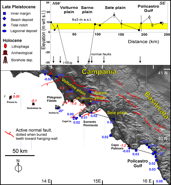
Vertical displacement rates (mm/yr) computed from the elevation of Late Pleistocene and Holocene markers plotted on a DEM of of Campania and Tyrrhenian Basilicata. Rate value with asterisk at Ischia is established on 33 Kyr deposits. Inset shows coast-parallel section of Lig marker elevation (slightly modified after Ferranti et al., 2006).
In the wide Volturno coastal plain north of Naples (Fig. 6), the LIg marker retrieved in borehole provides an average subsidence rate of ~0.5 mm/yr between ~125-40 kyr BP. The depth at which younger (inferred MIS 3, Romano et al., 1994) marine deposits are found in the same core suggests a half subsidence rate (0.2–0.3 mm/yr) for the last ~40 kyr. On the ridges bordering the plain to the east, the LIg marker was reportedly found above eustatic prediction (Ietto and Sgrosso, 1963; Romano et al., 1994), yielding a ~0.3 mm/yr uplift rate. Because ridges and plains are limited by extensional faults (Fig. 6), these might be active. It is possible, however, that the recent-most subsidence might have been fostered by volcano-tectonic collapse following emplacement of the Campanian Ignimbrite from a complex fissural center located in the Phlegrean Field volcanic district around 37 kyr ago (De Vivo et al., 2001). The slowing down-subsidence trend is confirmed by dated wood fragments in lagoon deposits (Barra et al., 1996), which indicate tectonic stability or even weak uplift at ~0.2 mm/yr during the last 5 kyr (Fig. 6).
Within or very near to the Phlegrean Field caldera centre, dramatic uplift is associated to local volcanic processes. Uplift of the Ischia island at over 20 mm/yr during the last 33 kyr (Barra et al., 1992) is attributed to block resurgence inside a pre-existing caldera (Orsi et al., 1991). Today, large subsidence at Ischia is indicated by SAR and terrestrial levelling data (Manzo et al., 2006), with a lower bound value related to fault activity and/or de-pressurization of the hydrothermal system. Historical uplift at the famous site of Pozzuoli was investigated since Lyell (1830) times and interplayed with subsidence as a result of shallow magma injection and withdrawal, at an average uplift rate of ~9 mm/yr (Morhange et al., 2006). Conversely, stability or slow subsidence is found at the Ponza and Ventotene islands further offshore (Fig. 6).
In the east, at Mt. Vesuvius volcano a ground uplift event of ~30 m is documented in the last 6 kyr, at an average rate of ~5 mm/yr (Marturano et al., 2009). In between the two uplift patches of Phlegrean Field and Vesuvius, the city of Naples experienced Late Holocene subsidence at ~1 mm/yr (Fig. 6; Cinque et al., in press). Subsidence since the LIg is found in borehole within the Sarno plain, south of Mt. Vesuvius volcano (Barra et al., 1991), at a rate (0.28 mm/yr) comparable to the Volturno plain in the north. South of there, in the Sorrento peninsula, the LIg marker indicates stability (Fig. 6), although very slow fault motion or creep is evidenced at Capri (Ferranti and Antonioli, 2008). The pattern evidenced at Capri and in the Sorrento peninsula is of minimal tilt to the NW, consistent with the geological structure (Fig. 6).
In summary, the elevation pattern of the LIg and younger markers indicates long-term subsidence in the plains at 0.3-0.5 mm/yr (with a slowing-down trend in the north), stability but possibly retailing of the promontories, and dramatic uplift followed by moderate subsidence in the volcanic areas.
A different history of vertical displacement is found in southern Campania, where the Late Pleistocene strandlines indicate generally weak uplift at up ~0.1 mm/yr and only locally subsidence (Ferranti et al., 2006; and references therein). Due to the very low rate, no information is provided by the Holocene marker, although local subsidence is inferred at Capo Palinuro based on archaeological data (Lambeck et al., in press), in a manner consistent with the Lig marker (Fig. 6).
Calabrian Arc
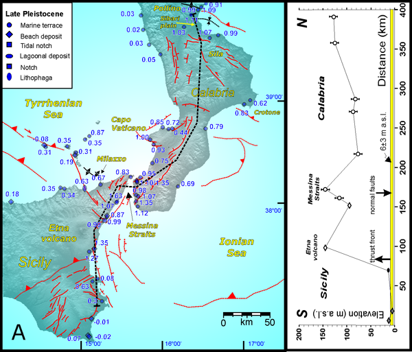
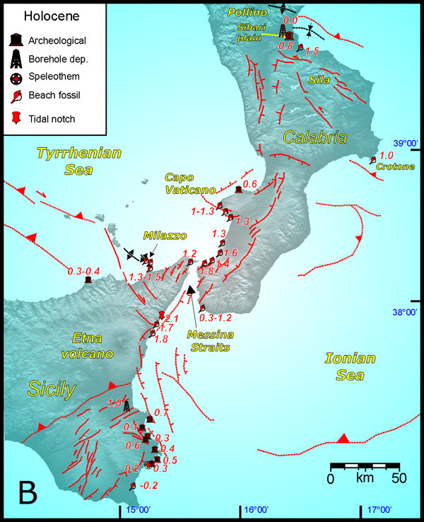
On the Tyrrhenian Sea side of Calabria (Fig. 7a), the LIg marker elevation (Ferranti et al., 2006, and references therein) provides average uplift rates which peak abruptly at Capo Vaticano (~0.6-1.2 mm/yr, and up to 2 mm/yr according to Tortorici et al. 2003) and again to the south in the Messina Straits (~1.0-1.4 mm/yr) between Calabria and Sicily. Along the eastern Sicily coast, rate decreases steadily south of the Messina Strait and attains a quasi-eustatic elevation at the southern tip of the island (Antonioli et al., 2006).
The uplift pattern in this province of active extensional faulting (Fig. 7a) has been related to the interplay between regional and local (i.e. fault related) components of vertical displacement. Much of the so-called regional uplift is associated with the subducted Ionian slab (see Fig. 1; Cosentino and Gliozzi,1988; Miyauchi et al., 1994; Bordoni and Valensise, 1998), and a smaller fraction, estimated from offset terraces across the main faults, to upper crustal rebound in the footwall of extensional faults (Westaway, 1993; Tortorici et al., 2003; Catalano et al., 2003; Ferranti et al., 2007; 2008b). During the last 125 kyr, whereas regional uplift is estimated at 1 mm/yr, footwall uplift for individual faults was typically ~0.2 mm/yr on average (Westaway, 1993; Catalano et al., 2003), but might have peaked to 1 mm/yr during limited time intervals of clustered slip (Ferranti et al., 2007; Tortorici et al., 2003).
Figure 7b. Vertical displacement rates in the Calabrian Arc.
Vertical displacement rates (mm/yr) computed from the elevation of Late Pleistocene (a) and Holocene (b) markers plotted with main structures on a DEM of Calabria and eastern Sicily. Main structures from Monaco and Tortorici 2000, Catalano et al., 2003, Del Ben et al. (2007), Billi et al., (2007), Argnani et al. (2007) and Ferranti et al. (2009).
Holocene uplift rates in the region were found to be nearly 50% higher than late Pleistocene rates (Pirazzoli et al., 1997; de Guidi et al., 2003; Antonioli et al., 2006; 2009; Ferranti et al., 2007), peaking at ~2 mm/yr in the Messina Strait and north-eastern Sicily (Figs. 7a; 7b). Higher Holocene rates have been attributed to clustered fault activity which equals regional displacements (Ferranti et al., 2007). Both at the ~100 and the ~1 kyr BP scale, the uplift pattern in the Strait is asymmetric, with larger motion on the eastern (Calabria) side in the north and on the western side (Sicily) in the south, respectively. This occurrence may reflect the location of major faults and folds, albeit a contribution from the Etna volcano in the south is conceivable (Figs. 7a, 7b). Further south, along the SE Sicily coast, Holocene uplift rates decrease from 0.7-1 mm/yr between Catania-Siracusa and to 0.2–0.5 mm/yr and then to almost null south of Siracusa (Fig. 7b). The southward decreasing Holocene uplift pattern broadly mirrors the spatial trend evidenced by the LIg marker (Fig. 7a). These data are consistent with a general southward decrease of both the regional uplift and the remote effect of active faults, either located in the Ionian offshore (Bianca et al., 1999) or in the Hyblean block (Fig. 7).
Along the northern shore of Sicily, both the long- and short-term markers documents that the large uplift province of the Calabrian arc grades westward to quasi-eustatic values. In the Milazzo headland, cumulative Holocene uplift occurred at 1.3-1.5 (locally up to 2.1) mm/yr, with ~0.65 mm/yr attributed to regional, steady processes, and the rest to co-seismic events (Scicchitano et al., in press). The Holocene regional uplift there is equal to the cumulative Late Pleistocene rate, and thus co-seismic structures are either very recent or have a limited long-term slip rate. Unlike the Messina Straits, the local sources responsible for co-seismic effects in this area are seek in an NNW–SSE striking transpressive belt, known as Aeolian-Tindari fault, that has caused the growth of Middle Pleistocene folds beneath the sea-bottom (Figs. 7a, 7b Argnani et al., 2007). Current contractional strain is also evidenced by dense geodetic network observations in the nearby southern Aeolian islands (Mattia et al., 2008). Further west along the Sicily shore, an abrupt decrease in both the Pleistocene and Holocene uplift rate is observed just west of the fault belt (Figs. 7a, 7b), point to its contribution to coastal deformation. In the Aeolian Islands, the LIg marker is generally uplifted at 0.2-0.3 mm/yr, but geoarcheological and GPS data document high Late Holocene uplift (1.9 mm/yr) and current (Fig. 18a) subsidence.
On the Ionian Sea side of Calabria, uplift rates recorded by the LIg terrace are slightly weaker (0.6-0.8 mm/yr) along a 300 km stretch of coast till the border with the Basilicata region (Fig. 7a). In these sector, no major faults are mapped at the coast and large earthquakes are not recorded, and so vertical displacement might chiefly embeds the regional component. Along the coasts of Sila and Pollino mountain ranges in northern Calabria, however, the LIg terrace indicates again uplift rates of magnitude similar to southern Calabria (Fig. 7a). Unlike the Tyrrhenian side of Calabria, however, uplift was attributed to the combination of regional uplift and growth of crustal transpressional folds, as indicated by on-land and marine morphotectonic data (Ferranti et al., 2009; Santoro et al., 2009).
Similarly, Holocene rates are only established in the Crotone promontory and approach 1 mm/yr (Fig. 7b). Further north, borehole data from the Sybaris archaeological area point to intense subsidence (Pagliarulo, 2006 and references therein), that, however, was limited to a ~2 kyr interval during the Mid-Holocene climax and only affected the ancient Sybaris (Ferranti et al., in press). Elsewhere around, either weak subsidence or uplift occurred throughout the Holocene (Fig. 7b), reflecting the prevailing role of local folds over the regional process in the short term (Ferranti et al., in press).
Western Sicily
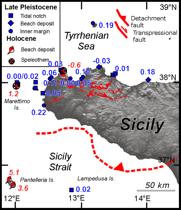
Along the coast of western Sicily, the LIg marker lies generally only a few metres above the predicted eustatic elevation (Fig. 8). In northern Sicily, local differences particularly along small promontories standing out from the main coastline run are explained by displacement on faults which in few cases cut through the LIg terrace (Antonioli et al., 2006). Most of these faults are transpressional, and are possibly reflected in the pattern of GPS velocities (Ferranti et al., 2008). Thus, weak coastal uplift and subsidence may locally occur along restraining and releasing bends, respectively, of faults. In south-western Sicily, the occurrence of the LIg terrace is poorly constrained, although it is locally suspected to lie above its eustatic elevation as a result of active thrust uplift.
Figure 8. Vertical displacement rates in western Sicily.
Vertical displacement rates (mm/yr) computed from the elevation of Late Pleistocene and Holocene markers plotted on a DEM of of western Sicily.
In the whole region, the Holocene marker is only found in the most north-western part of Sicily (Fig. 8), where it provides 1.2 mm/yr uplift in the Egadi island and weak subsidence at S. Vito Lo Capo west of Palermo (Lambeck et al., in press). Large uplift (4-5 mm/yr) in the last kyr or so is only documented at Pantelleria island in the Sicily Channel (Fig. 8) as a result of episodic inflation processes related to magmatic intrusion along feeding fissures (de Guidi and Monaco, 2009).
Northern Ionian Sea margin
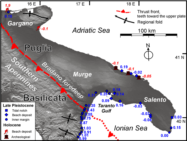
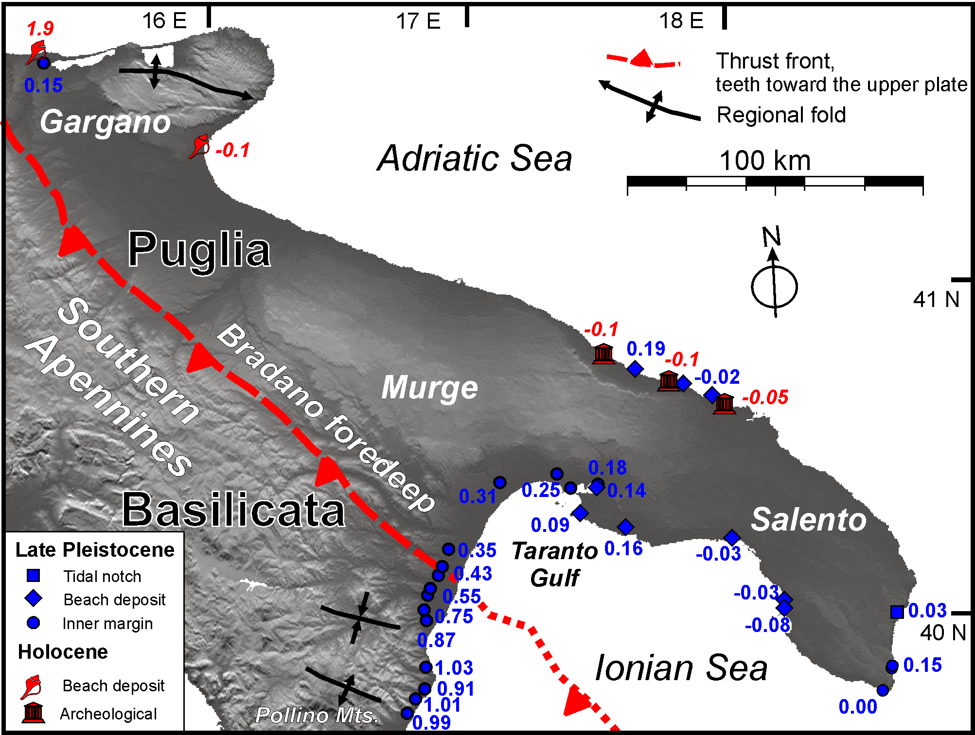
Like in Sicily, the elevation of the LIg terrace decreases steadily to the NE along the former foredeep basin of the Southern Apennines thrust belt, to a minimum at the northern and eastern shore of the Taranto Gulf (Fig. 9). No significant jump in the regional uplift pattern is observed crossing the front of the Southern Apennines (Fig. 9), supporting the notion that thrust displacement had vanished by the onset of the Middle Pleistocene (Patacca and Scandone, 2007), although according to Caputo et al. (2010) a break does exist and higher cumulative rates are encountered. Be as it may, large-wavelength uplift tapering to the north is consistent with the longer-term history of the region, characterized by uplift since the middle Pleistocene (Westaway, 1993; Westaway and Bridgland, 2007; Caputo et al., 2010). On the other hand, no information exists for the short-term vertical deformation pattern.
Figure 9. Vertical displacement rates in southeastern Italy.
Vertical displacement rates (mm/yr) computed from the elevation of the Late Pleistocene and Holocene markers plotted with main structures on a DEM of Basilicata and Puglia (slightly modified after Ferranti et al., 2006).
South-central Adriatic margin
This coastline straddles the partly deformed foreland of the Apennines and is morphologically split in uplifted bedrock blocks (Gargano, Murge, and Salento) in the Apulia region in the south, and terraced coastal plains in the north (Figs. 4, 5, 9).
In the south, the LIg marker has a quasi-eustatic elevation along the Salento shores of Puglia region, but a limited accuracy surrounds its definition (Ferranti et al., 2006). Similarly, poor constraints are available in Gargano and Murge further north (Fig. 9), and along the central Adriatic coastline from Molise to Emilia-Romagna region (Fig. 5).
Significant Holocene uplift is reported on the northern Gargano shore at a rate (~2 mm/yr) which is unmatched by the nearby LIg marker (~0.2 mm/yr; Fig. 9), a fact attributed to a current high-release seismic cycle (Mastronuzzi and Sansò, 2003). This tectonic block is characterized by ongoing seismological transpression (Fig. 2), and thus the invoked model might be feasible. Along the southern shore, however, lesser Holocene uplift is recorded by geoarcheological markers (Fig. 9; Antonioli et al., 2009), and thus the block might be pushing and tilting northward. Along the Salento shore, geoarcheological markers (Antonioli et al., 2009) suggest weak subsidence up to 0.1 mm/yr, in agreement with the long-term pattern.
Unlike Apulia, the central Adriatic coastline runs parallel to the foothills of the thrust belt, which is still tectonically active beneath the coastal region and the Adriatic Sea (Lavecchia et al., 1994; Pondrelli et al., 2006). Along the Marche and southern Emilia coastline, the LIg terrace shows weak uplift (Fig. 5) with a few km wavelength, suggestive of segmented fold growth (Vannoli et al., 2004). Conversely, mild subsidence is evidenced by few Holocene data (either boreholes or geoarcheological markers) at the Marche and Abruzzi regions coastline (Fig. 5).
Northern Adriatic margin
The northern Adriatic region straddles the transition from the Adriatic foreland and Dinarids belt in Slovenia and Croatia to the east, the southern Alps to the north, and the northern Apennines to the southwest (Fig. 2). During the Neogene, progressive convergence of these orogens shrunk the Adriatic foreland plate now submerged beneath the Adriatic sea and covered in the northwest by the Po plain sediments. Current shortening occurs at the Alps and Apennines front, and transpression is recorded inland of the Dinaric coast (Fig. 2; Pondrelli et al., 2006; Devoti et al., this issue).
In the south, a Neogene south-westward thickening (up to 2 km) foredeep wedge (Carminati et al., 2003) was deposited in front of the advancing Apennines thrust belt, and is today reflected in the modern Po River Plain. Asymmetric subsidence continued after Late Pleistocene as documented by the depth and geometry pattern of the LIg deposits reconstructed by borehole analysis (Amorosi et al., 2004; Ferranti et al., 2006; Antonioli et al., 2009). As a matter of fact, high subsidence rates (~0.9-1 mm/yr) are found in the Romagna region in front of the Apennines mountains and just above a deep thrust belt (the Ferrara arc, Fig. 4). This buried arc is seismically active (Fig. 2), and thus regional subsidence interplaying with imbrication of the LIg marker is feasible. Sites located further north display decreasing subsidence from 0.6-0.7 to 0.5-0.6 mm/yr in the Veneto and in the Friuli coastal plains, respectively (Fig. 4), consistent with a northward-tapering flexure model. South of the locus of maximum subsidence in Romagna, the projected position of the coastal Marche site (section in Fig. 5) is consistent with this model.
Holocene data partially mimic the long-term pattern (Fig. 4). Several borehole markers show subsidence of ~0.3-0.9 mm/yr along the whole coast from Emilia to Friuli (Antonioli et al., 2009). The sites with larger Holocene subsidence (1 mm/yr) are located both in front of the Apennines and, unlike the old markers, of the Alps. The northern sites with highest Holocene subsidence are closer to the active thrust front of the Southern Alps (Montello thrust, Fig. 4), and thus a component of loading from the Alps may not be neglected.
In the eastern part of northern Adriatic (Trieste Gulf and Istrian coastline), sparse evidence from the LIg exists, but a wealth of Holocene archaeological and geomorphological indicators are available (Antonioli et al., 2009). It appears that vertical displacement in the Trieste Gulf (Fig. 4) changes southward from uplift to to ~0.8 mm/yr subsidence at the northern border of the Istria promontory. Similarly, an opposite pattern of northward increase in subsidence is observed moving north from Trieste along the shore of the Gulf from weak uplift to -0.8 mm/yr downlift (Furlani et al., 2011). This pattern may also be reflected by a contemporary tilt to the northwest between Trieste and the Friulian plain detected by long-base tiltmeters data (Braitenberg et al., 2005). Weak uplift has been detected also in cores drilled offshore Trieste, an occurrence interpreted as reflecting active growth of an NW–SE trending anticline which is imaged in seismic reflection profiles (Antonioli et al., 2007). In summary, although the locus of seismological deformation in this region is shifted inland and is expressed by strike-slip motion along the Idrija fault (Burrato et al., 2008), the differential pattern of Holocene subsidence and uplift along the north-eastern Adriatic coast is attributed to active shortening of the frontal Dinarids (Antonioli et al., 2007; Furlani et al., 2011).