Discussion
The appreciable length of Italy coastline and the coexistence of different geodynamic processes acting in close proximity, along with a rich suite of observational data spanning from the 100 kyr to the contemporary scale, allows to single out a variety of vertical tectonic behaviours in spatially adjacent regions. In addition, the existing dataase highlights, for individual sectors the contributions ensuing from processes acting at different depths and bearing different wavelength and amplitude signals, and the temporal scale of changes for these processes. In the followings, three main segments of the nation coastline are taken as representative of as many different tectonic behaviours and serve to illustrate the interplay between regional and local deformation.
Regional stability and local tectonic and volcanic displacement: western Italy.
The Sardinia, Liguria and northern Tyrrhenian Sea margins emerge from coastal analysis as sectors of stability at regional scale, with only sub-regional or local activity due to fault motion and volcanic processes. This behaviour is revealed by the LIg marker and is confirmed by Holocene (mainly archaeological markers) and by instrumental data (Figs. 3 to 6 and 12 to 15). Weak and very localized subsidence (e.g. promontories of Sardinia; small coastal plains of Campania and Latium) or uplift (e.g. Liguria and Toscana cliffs adjacent to plains) provided by LIg data occurs in regions of modest or null seismicity and thus might reflect creep and/or isostatic motion. This low-rate pattern can be rarely assessed by the Holocene markers. Higher subsidence, where a tectonic contribution seems viable, is locally encountered within larger coastal plains bounded by ostensibly active faults. This situation has been encountered in the Arno plain in Tuscany, where it was possible to isolate the contribution of footwall uplift, hanging-wall subsidence and sediment constipation on the southern border fault (see section 5.3.), resulting in a 0.3-0.5 mm/yr vertical slip rate in the last 125 kyr; or within the GDR and Fondi plains in southern Latium (Fig. 5); and the Volturno plain in Campania, where plain subsidence and mountain flank uplift points to active fault displacement (Fig. 6). In Campania, similar results with uplift in the Apennines and rapid subsidence in the plains is documented by radar interferometry (PS-Insar) data published by Vilardo et al (2008), who infer active motion along ~NW-SE to NNW-SSE striking faults bordering the chain.
A characteristic feature of the western Italian margin evidenced by its effects on coastal markers is represented by volcanic processes. Typically, these processes are signalled by a smooth and laterally limited (10 to 100 km) uplift profile of the LIg marker, and are attributed to the construction of small explosive edifices or to the emplacement of lava flows (eastern Sardinia and Latium). Where the Holocene marker is used, such as in the case of the Phlegrean Fields and Mt. Vesuvius in Campania (Fig. 6), it was possible to single out extremely rapid (1-2 cm/yr) but transient (<<100 kyr) episodes of magmatic unrest. It is worth to note that in the case of Latium volcanic province, where activity is not as dramatic as in Campania, Holocene borehole and tide gauge (Ci) data locally provide a ~0.2-0.3 mm/yr uplift of the same magnitude of that provided by LIg markers (although Holocene archaeological data show weak subsidence; Fig. 5). Remarkably, a ~0.2-0.3 mm/yr uplift rate was also sustained in the Latium volcanic area since the Early Pleistocene (Mancini et al., 2007). Integration of all these observations might suggest that at the Latium coast a regional component of (deep?) magmatic deformation has occurred at almost steady rates, and transient effects are no longer detectable.
Major volcanic processes caused not only uplift, but also subsidence of coastal markers. A contribution arising from magma chamber withdrawal and volcano-tectonic collapse related to past exceptional eruptions (e.g. 37 and 15 kyr BP events) is probably embedded in the subsidence recorded in Campania (Fig. 6). Whereas subsidence in the plains may have slowed down or stopped during the Holocene, it is still occurring in the city of Naples as documented by Holocene (-1 mm/yr) and tide gauge (-0.6 mm/yr; Fig. 12) data, although anthropogenic effects are probably folded within these estimates.
Apart the localized and episodic volcanic deformations or fault-related subsidence in large coastal plains, analysis of coastal displacement markers lend to the conclusion that the continental margins of western Italy have reached a mature and thermally cooled stadium. This finding is consistent with seismicity, horizontal GPS velocities, and geologic reconstructions that place the locus of active deformation along the axis of the Apennines and not west of it, where regional tectonics has ceased (Figs. 1, 2).
Interplay between regional and local tectonic displacements: southern Italy.
A difference in vertical tectonic behaviour between western and southern Italy coastlines is manifest. Since the middle Pleistocene, eastern Sicily, Calabria, and eastern Basilicata have experienced rapid and coherent uplift, documented by flights of marine terraces (Dumas et al., 1987; Westaway, 1993; Miyauchi et al., 1994). Uplift rates documented by the LIg and older markers form a bulge elongated for ~350 km in a NE-SW direction, and with a minimum ~100 km width between the Tyrrhenian and Ionian Sea coasts. The bulge exhibits two peaks centered in the NE (north-eastern Calabria) and in the SW between the Messina Straits and the Etna volcano in central eastern Sicily (Fig. 7a). Whereas the peaks record 125 kyr uplift rates of >1.2 mm/yr, the elongated saddle between them has a background uplift value of ~0.8 mm/yr. Outside the peaks, uplift rates decrease sharply to the NE in Basilicata and Apulia, to the W in northern Sicily and to the S in southern Sicily, where they drop off to null within a ~50 km stretch (Figs. 7a, 8, 9).
An interesting conundrum presented in this study, which was not assessed in our recent papers (Lambeck et al., 2004; 2011; Ferranti et al., 2006; Antonioli et al., 2009) regards the possibility that the southern margin of the Tyrrhenian Sea in north-western Sicily may began to be involved in regional deformation. As a matter of fact, tide-gauge (Palermo) and Holocene (Marettimo Island) data suggest significant uplift at these sites at a rate which is not recorded by LIg markers (Fig. 8). Although this evidence is local and thus must be taken cautiously, it might pose the question whether north-western Sicily is witnessing a very recent inception of uplift, possibly in response to a relative convergence with Sardinia which is currently recorded by geodetic and seismicity data (Fig. 2; Serpelloni et al., 2005; Pondrelli et al., 2006; Ferranti et al., 2008). Further studies on the Holocene markers in western Sicily are needed to address this point.
On a more general issue, there is a general consensus that post 0.8 Myr surface uplift of Calabria embeds components from two different sources, one regional and the other operating at a local scale (Valensise and Pantosti, 1992; Westaway, 1993). Because of the spatial alignment between the uplift bulge and the strike of a seismically active, NW-dipping lithospheric slab (Fig. 1), the regional contribution to uplift has been interpreted to arise from a deep-seated source (e.g. Westaway, 1993; Wortel & Spakman, 2000; Gvirtzman & Nur, 2001). Geodynamic reconstructions have paid less attention to the causes of local uplifts and on the tuning between deep and shallow sources at different timescales, and we further explore these issues in the following.
Although located within a plate convergence zone, much of Calabria topography was acquired during extension (Monaco & Tortorici, 2000), and a substantial fraction of uplift was attributed to slip on active normal faults (Westaway, 1993; Catalano et al., 2003). Conversely, on the eastern (Ionian) side of the Calabrian arc, a mounting body of evidence points to whole crustal and possibly lithospheric shortening as driving a significant amount of uplift (Ferranti et al., 2009; Caputo et al. (2010). Similarly, crustal shortening and transpression may be contributing to uplift of the western part of the arc in northern Sicily (Figs. 7a).
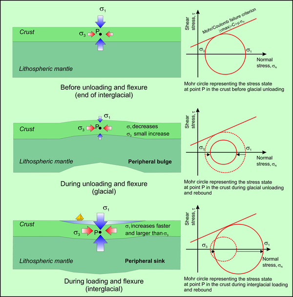
Figure 19. State of stress changes due to GIA.
State of stress before, during, and after glacial loading and flexure in a region of active extension, where the maximum principal stress is vertical (adapted from Hampel & Hetzel, 2006).
Study of displaced Holocene shorelines around the Calabrian arc coastline indicates average uplift rates consistently higher than longer-term rates, but the location of sites having the fastest Late Pleistocene and Holocene uplift rates spatially coincide (compare Figures 7a and 7b; Antonioli et al., 2006). Inspection of short-term (Holocene), secular, and present-day displacement estimates, the latter two provided by archaeo-geodetic markers and tide-gauges, respectively, suggests that the pattern established in the Holocene continues today. Archaeological and instrumental data, however, do not have the capability of partitioning between regional and local sources, but they do suggest significant (elastic?) strain accumulation.
Detailed work along the Messina Straits shore has shown that the Holocene increase in uplift rate is related to temporal clustering of slip, possibly accommodated on offshore normal faults (Ferranti et al., 2007; 2008). On the contrary, regional uplift progressed during the Holocene at a rate of ~1 mm/yr, similar to the long term estimation (Westaway, 1993), pointing to a time-interval larger than 100 kyr as appropriate for major geodynamic changes. Appraisal of the present elevation attained by a suite of 125 kyr and younger marine terraces has shown that rapid vertical displacement of coastal terraces across faults also occurred during the Lig highstand (125-80 kyr). Comparable results, with enhanced fault slip/fold growth rates during the LIg and the Holocene, can be documented elsewhere in the Calabrian Arc both in the extensional hinterland (e.g., Messina Strait, Catalano et al., 2003; Taormina, de Guidi et al., 2003; Capo Vaticano, Tortorici et al., 2003; Cucci and Tertulliani, 2006) and in the transpressional foreland (e.g. north-east Calabria Ferranti et al., 2009; Santoro et al., 2009). The observation that the temporal variations in slip rate are maintained both in the extensional hinterland and in the transpressional foreland, strongly points to an external forcing of fault slip clustering. This mechanisms might be operating at the border of the uplifting bulge, where rates are 30% greater than the background value at the locations where local structures approach the coastline or penetrate in the land interior (Figs. 7a, 7b).
The fact that efficient seismic (or aseismic) strain release appears clustered in intervals of 10-20 ka during interglacial stages along many coastal or offshore local structures requires further inquire. We suggest that simultaneous clustered activity of local structures during interglacial highstands may record increased hydrostatic load and peripheral bulge collapse triggered by isostatic adjustment to mantle flow (Fig. 19). By contrast, fault rupture was inhibited by the concurrent reduction in vertical load and in pore pressure during glacial hydrostatic unloading and growth of the peripheral Mediterranean bulge to the continental ice. The episodic contribution of interglacial displacements over the steady back-ground uplift has led, in the long-term, to a prevailing regional signal (Fig. 19).
Dominance of regional tectonic displacements: eastern Italy.
Unlike the western Italy margin, the signature of regional deformation is still detected on the eastern side of the nation along the Adriatic Sea shore, where vertical displacement of coastal markers occurs in a province of contractional and transpressional tectonics. In the southern Adriatic and northern Ionian Sea coasts, deeper shortening and strike-slip faulting occurs mostly offshore within the Apulia foreland block, but its effects are also recorded on-land by long- and short-term markers (Fig. 9). Vertical displacement, particularly of the Holocene marker, is higher at the Gargano block (Mastronuzzi and Sansò, 2002), consistent with the geological history of the foreland, where Neogene mid-plate deformation was stronger and more prolonged than further south (Ferranti and Oldow, 2006).
Similarly, Late Pleistocene and Holocene markers testify of localized slow coastal uplift or subsidence in the northern section of the central Apennines, and confirms geological and present-day contractional motion along the front of the belt. Weak uplift rates (< 0.1 mm/kyr) of the LIg terrace in the Marche region are related to low-amplitude folds growing underneath the coast (Vannoli et al., 2004). This situation occurs behind the active offshore frontal thrust and in the hanging-wall of an inner thrust which borders the mountainous topography of the northern Apennines (Figs. 4, 5). Thus, along the Adriatic shore, the transition from mid-plate deformation in the south to frontal thrust belt motion in the north occurs north of Gargano, in agreement with geodetic and seismological information (Fig. 2).
Further to the north, recorded displacement changes along the coast from weak uplift to strong subsidence (Fig. 4). Tectonic downlift in Romagna region happens at a rate of ~1 mm/yr both at the 100 and at the 10 kyr scale behind the buried frontal thrust of the Apennines (Ferrara Arc), and in the footwall of the inner thrust which forms the chain escarpment. The subsidence pattern is explained with a flexure situated in front of the Apennines, and involving the foreland plate subjacent the frontal detachment of the orogen. Minor imbrication occurs above the inner thrust as recorded by the weakly uplifted Marche sites (Fig. 4). Lateral continuity of the active inner thrust front is supported by seismological data (Fig. 2) and by analysis of geologic and fluvial geomorphologic data (Picotti and Pazzaglia, 2008). However, the minimal vertical uplift rates (0.1 mm/yr) caused by thrust imbrications are ten times lower than the regional subsidence. Prevailing regional subsidence over secondary thrust imbrication documented by the LIg terrace is consistent with models of frontal accretion in rapidly retreating slabs, as it is thought to happen in the western Adriatic context (Doglioni et al., 1999). Today, this pattern is confirmed by integration of gravity, interferometry and GPS observations, which show foredeep subsidence at ~3.3 mm/yr and uplift of the Romagna Apennines at ~1 mm/yr (Zerbini et al., 2007). The larger instrumental rates when compared to geologic rates profoundly incorporates the anthropogenic effects.
Foreland subsidence decreases towards the fronts of the southern Alps and Dinarids, in a manner consistent with a northward-tapering flexure, and mirrors the long-term (106 yr scale) foredeep geometry. Although the northern sites are closer to the active thrust front of the Alps, it appears that both at the intermediate- and short-term (100-10 kyr) time interval, the effect of thrust loading from the Alps is minor compared to the down-to-southwest flexure of the Adriatic plate beneath the Apennines experienced by the Romagna sites. The process underlined by the Late Pleistocene-Holocene coastal markers supports the model of asymmetric slab retreat for the two oppositely verging thrust belts (Doglioni et al., 1999; Mariotti and Doglioni, 2000).
There may be however, hints of active thrust loading from the Alps, too. Holocene sites with large (1 mm/yr) subsidence are not only located in front of the northern Apennines, but also near to the Alps in the north (Fig. 4). Although uncertainty in borehole data interpretation is large due to possible sediment constipation, there appears to be for the northern sites a coincidence between largest subsidence and highest proximity to the Alpine front. This advanced part of the Alpine chain overlies one of the most active strands of the segmented south-alpine frontal thrust (the Montello thrust, Fig. 4; Benedetti et al., 2000; Burrato et al., 2008). The sites with larger Holocene subsidence are located in the thrust footwall and within ~40 km from the thrust tip-line. Although direct coseismic subsidence is unlikely (Carminati et al., 2003), when the thrust nucleation depth and flexural rigidity of the Adriatic plate are taken into account, subsidence induced by interseismic thrust loading might be substantial, instead (e.g. King et al., 1988). We cautiously suggest that a fraction (in the order of ~0.5 mm/yr, consistent with simple calculations of viscoelastic flexure) of Holocene subsidence north of the Venice lagoon might be caused by loading related to the current seismic cycle. This occurrence should not be recorded in the long-term data, which average over many cycles of quiescence and co-seismic slip. As a matter of fact, average subsidence rates for this sector are ~0.4 mm/yr for the last 600 kyr (Kent et al., 2002), and ~0.5 mm/yr for the last 125 kyr (Ferranti et al., 2006). Pleistocene rates cannot be readily compared to the short-term rates, which may witness a phase of rapid tectonic subsidence coupled to un unknown amount of constipation. East of Venice, Holocene lagoonal sediments older than 6 kyr show tectonic rates of 0.6 mm/yr or lower (Antonioli et al., 2009), similar to the long-term subsidence after an initial compaction. Thus, ~0.5 mm/yr may be taken as the regional subsidence rate in this area, and an equal component of thrust loading and constipation add to the remaining.
The more general conclusion drawn from appraisal of the northern Adriatic data relates to the constancy of deformation rates. Unlike the Calabrian arc, where short-term displacement rates are consistently higher than rates established using the LIg data, in the coastal Po plain rate and spatial extent of displacements are steady over the different time-scales considered here (Fig. 4), including perhaps the tectonic component of tide-gauge record at Venice station (1955-2000). We argue that, unlike the south, local structures have a less important role at this coast, and the more substantial contribution to deformation comes from flexure of the Adriatic (micro)-plate which, at the temporal scale under scrutiny, is constant. The secondary role of local structures may derive both from their higher distance from the coast and their more limited size relative to what happens in the south. Only locally it is possible that the effects of local structures are recorded by coastal markers, as it is argued here for the higher subsidence of Veneto sites close to the active Montello-Conegliano thrust, which may be affected by a non-elastic component of footwall displacement (see section 5.9).