The Western Termination of the Tethys Seaways
Sedimentation during the time interval from the end of the Lower Triassic till the Carnian/Norian boundary occurred in a complex geodynamic scenario. The Southern Alps are the site where these phenomena are better preserved and exposed. The unique landscape of the Dolomites in particular led recently to recognition of these mountains as World Heritage from UNESCO.
The southernmost Apennines and Sicily had a rather different setting and will shortly be discussed separately.
The Southern Alps
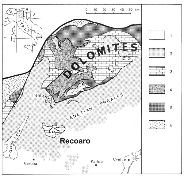
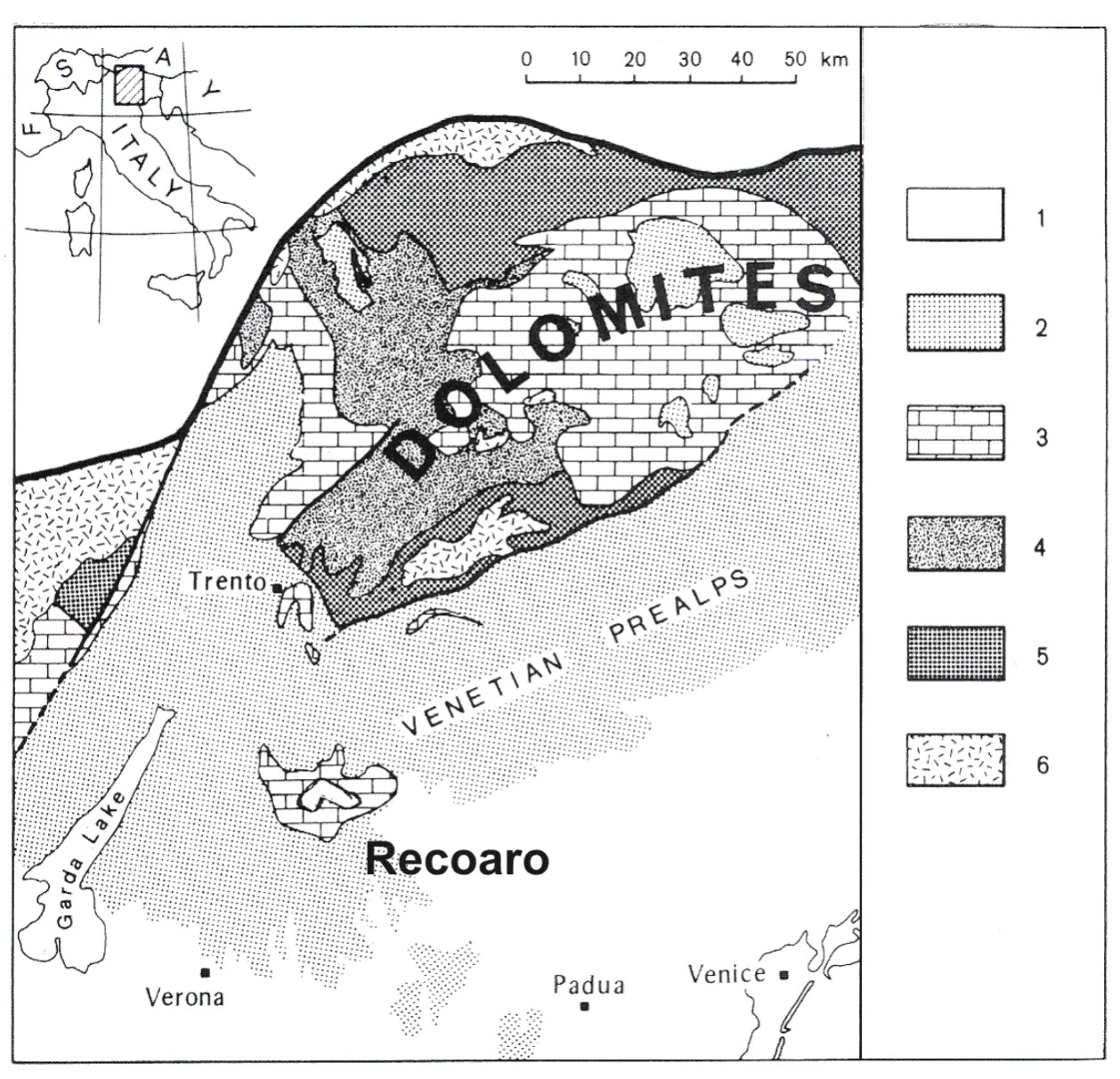
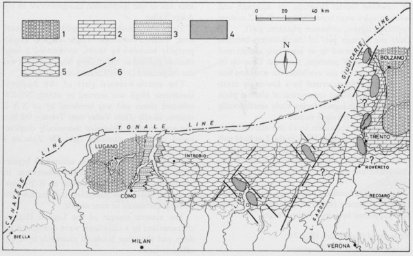
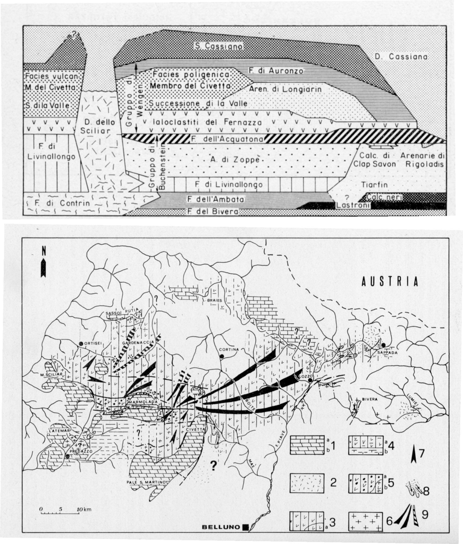
The Triassic of the Dolomites has been a key reference for the Triassic for more than a century, and some of its features, like the concept of intefingering of facies, were first proposed on actual occurrence from the Dolomites (Mojsisovics, 1879). The great advantage of the Dolomites is the relatively low shortening and deformation during the Alpine Orogeny (Fig. 13). Other areas have importance in the history of science, like the section of Recoaro, first drafted by Arduino (1760) (Fig. 14). Lombardy and the Carnic Alps are also significant, even if alpine tectonics may locally mask a detailed analysis. After 150 years of stratigraphic studies, the terminology is very complex and a reader unfamiliar with the area may find it difficult. This is due first to the actual complexity of the stratigraphic record and also to the fact that the area of the Southern Alps was initially ruled by different states (Italy and Austria). To follow, in detail, the stratigraphy of the Anisian to Carnian in the Southern Alps would require tens of pages.
Figure 13. Historical areas.
The Dolomites and the Recoaro area have also an historical interest in the history of stratigraphy and of the Triassic researches. 1. Alluvial deposits. 2. Jurassic to Cenozoic deposits. 3. Triassic successions. 4. Permian ignimbrites and sedimentary successions. 5. Variscan intrusives. 6. Variscan metamorphics. The Dolomites are bounded to the north by the Insubric Lineament. (From Bosellini and Rossi, 1967, modified).
Figure 14. Recoaro area.
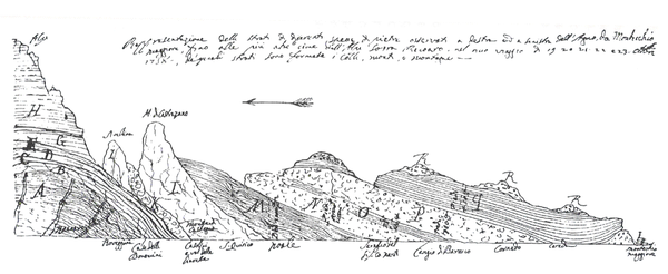
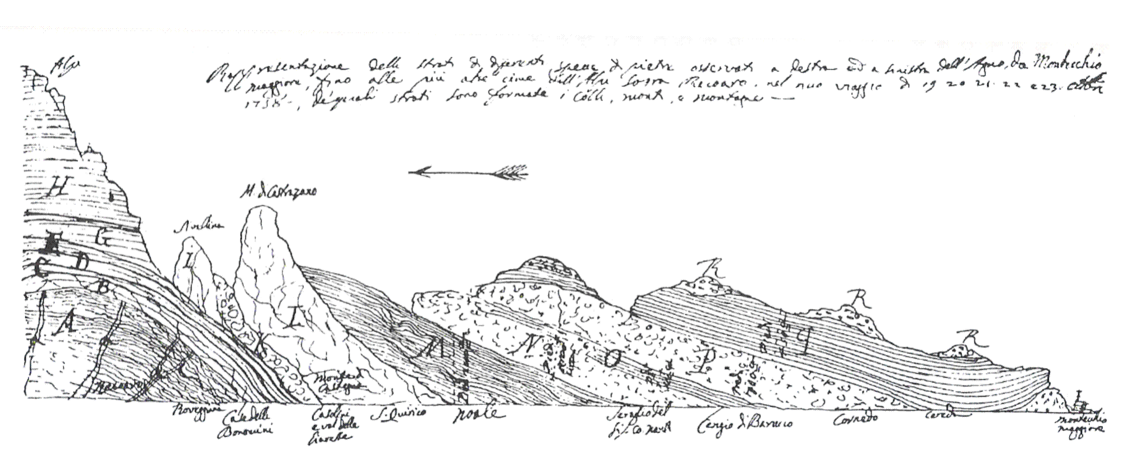
The drawing of Giovanni Arduino (1760) through the Valle dell’Agno in the Recoaro area. The calcareous peaks on the left side correspond to the Middle Triassic Spitz Lmst. From Stegagno (1929).
To summarize and search for some common features, I would stress the following common points:
1. High subsidence rate, mostly compensated by high carbonate productivity, often result in very thick successions.
2. Subsidence was controlled by active tectonic movements, mostly extensional or transtentional.
3. Volcanic activity was significant from the late Anisian until most of the Carnian, with migration of the effusive centres and changes through the time of the geochemical signature. The overall trend is calc-alkaline.
The time interval may be subdivided in four parts.
The Anisian
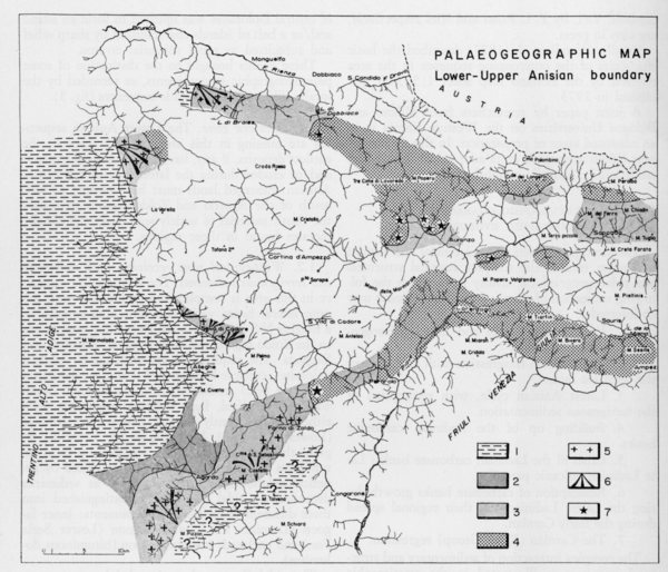
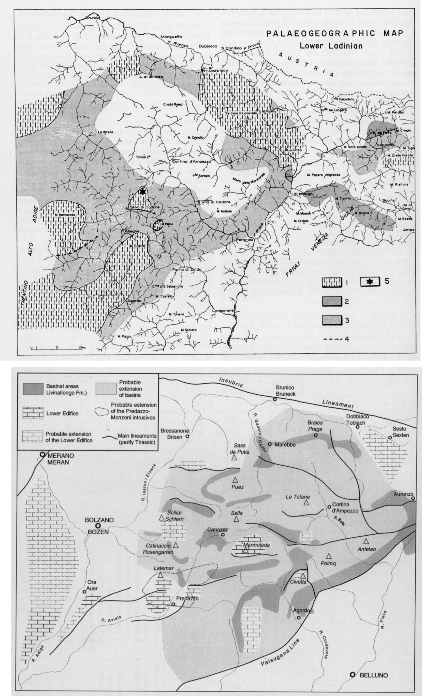
This interval roughly spans from the earliest Anisian until the beginning of the late Anisian. The age of the base is poorly constrained, lacking significant fossils, while the top is better defined. As a whole, the trend was toward a general aggradation of more frankly marine facies on the previous marginal to evaporitic sediments (Carniola di Bovegno in Lombardy, Lower Serla Dolomite in Dolomites, and Lusnizza Fm. in Carnia). Reliable age control is possible only with the middle Anisian (Pelsonian in the Tethyan substage terminology). Mixed carbonatic/very-fine siliciclastic ramps were a typical setting for the initial steps of the transgression, while thick carbonate banks first appeared in the geological record. These banks reached a thickness up to 300–400 m, mostly built by algal activity. They were still fairly isolated in the bays. Among the better preserved are the Camorelli Bank in Lombardy (Gaetani and Gorza, 1989; Berra et al., 2005), M. Guglielmo (Falletti and Ivanova, 2003), Dosso dei Morti in Trento Province (Gaetani, 1969; Unland, 1975), and M. Rite in Venetian Dolomites (Stefani et al., 2010) (Fig. 15).
Figure 15. Middle Anisian palaeogeography.
Paleogeography (non palinspastic) of the middle Anisian (Pelsonian ) in western and central Southern Alps (from De Zanche and Farabegoli, 1988, modified). 1. Emergent areas. 2. Carbonate peritidal lagoon. 3. Siliciclastic flats with calcareous interlayers. 4. Carbonate banks . 5. Carbonate embayements with fine terrigenous input. 6. Triassic synsedimentary fault.
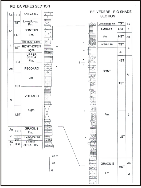
Another common feature was the presence of several conglomeratic horizons, testifying to local emersion and erosion episodes of the underlying Lower Triassic/Permian successions, like the Bellano Fm. in Lombardy (Gaetani, 1982; De Zanche and Farabegoli, 1983) and the well-known successions of conglomerate bodies around the margin between the Western and Eastern Dolomites—i.e., the Voltago and Piz da Peres conglomerates (Bosellini, 1967; Brandner and Bechstaedt, 1970; De Zanche and Farabegoli, 1988, Neri and Stefani, 1998; Stefani et al., 2010).
Extensional movements were locally active, forming scarps linked to faults. From the rifted shoulders, conglomeratic fans expanded in the nearby areas. Figure 14 illustrates the complex geological pattern of this first part of the development in the western Southern Alps.
During this time interval, no volcanic activity is proved.
Late Anisian-Ladinian
At about the middle–late Anisian boundary, a major differentiation occurred, with identification of areas that had a more proximal setting, emergent or with less subsiding during this time interval, and areas more subsiding in which deeper deposition prevailed. The active faulting occurred along lineaments that suggest the formations of sphaenocasm. Sinistral transtentional movements were also identified (Doglioni, 1987). In Lombardy, the Lario-Ceresio areas had another positive pulse (Fig. 16). The Western Dolomites and the Carnian Ridge emerged and were eroded down until the Upper Permian formations. The Richthofen Conglomerate and the Ugovizza Breccia are among the most significant products of this event (Figs. 17 and 18). The Eastern Dolomites instead were more basinal-prone and received the material eroded to the west and to the north (Fig. 19).
Figure 16. Base of Upper Anisian paleogeography.

Paleogeographic map (not palinspastic) of the base of upper Anisian. The topographic relief was rejuvenated and new areas emerged, feeding the nearby sea embayments with new terrigenous material (From De Zanche and Farabegoli, 1988). 1. Emergent areas. 2. Fluvial distributory channels. 3. Algal carbonate lagoon. 4. Carbonate platform. 5: Dismembered carbonate platform. 6. Siliciclastic fan-delta- 7. Siliciclatic offshore. 8. Anoxic shallow basin. 9. pelagic shelf (Prezzo Limestone) with alternating carbonate-clayey sedimentation.
Figure 17. Upper Anisian paleogeography in Dolomites.
Paleogeographic map (non palinspastic) for the middle-upper Anisian in Dolomites. Note the alignment of the emergent areas and depressions, forming a rhombochasm. This suggests the direction of the strain in W-E direction. 1. Emergent land. 2. Slow subsiding areas. 3. Areas with higher subsidence, that will later became basin. 4. Carbonate bank. 5. Extension of conglomeratic and sandy bodies. 6. Main alluvial fans. 7. Ore deposits. (From Assereto et al., 1977).
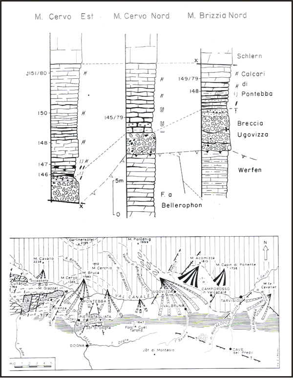
Figure 18. Ugovizza Breccia.
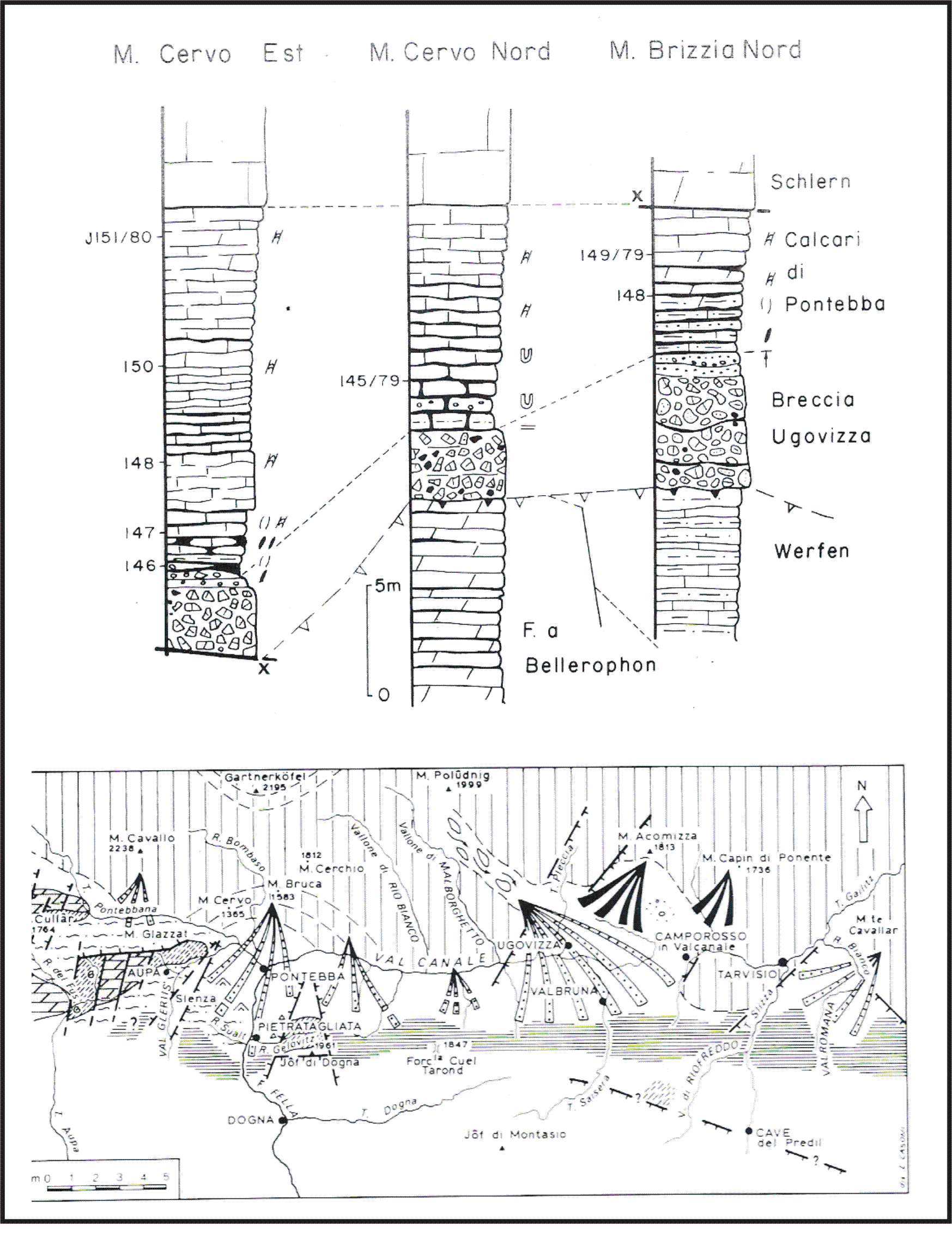
A. Logs measured on the “Palaeocarnic Ridge” (Dorsale paleocarnica) showing the depth of the erosion before the deposition of the Ugovizza Breccia (from Fois and Jadoul, 1983).
B. Partly palinspastic reconstruction of the fluvial channels and fans along which the Ugovizza Breccia was transported and deposited to the S of the Palaeocarnic Ridge (from Farabegoli et al., 1985).
Figure 19. Relationship basin/paleohigh.
An example of the relationships between paleohigh and basin in the Anisian of the Northern Dolomites, Braies area. (From De Zanche et al., 1993).
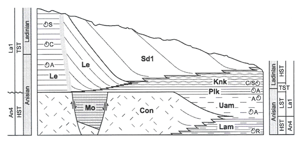
Toward the end of the Anisian, the subsidence rate increased on most of the Southern Alps. As a result, areas that were emergent or in a shallow-water setting became the preferential sites for the growing of carbonate platforms. Deeper areas continued their basinal trend. This is the right situation that makes the landscape of Western Dolomites classical, with steep walls in the massive limestone or dolostone units, dominating gentle green slopes made by the softer, bedded limestone, marly, and shaly units. Due to the minor alpine shortening suffered by the Dolomites, interfingerings in the original settings are preserved, and since Mojsisovics (1879) are amongst the most studied examples of these phenomena (Fig. 20). A similar setting was also present in Lombardy and Carnia, but the more severe alpine tectonics disrupted the original relationships and the softer basinal units often form the sole of the thrusts. In Lombardy, a good example may be observed in the Grigna Mountains, where the upper Anisian-Ladinian carbonate platform of the Esino Fm. is well preserved and its margin may be studied (Landra et al., 2000) (Fig. 21). Margins typically prograded on the basin only a few hundreds of metres because they were facing deep troughs and productivity was insufficient to fill the deep and subsident basin. Therefore, slope inclination of the margins has grown high, often up to 30 degrees (Fig. 22 ).
Figure 20. Lower Ladinian Palaeogeography.
Palaeogeography of the lower Ladinian in Lombardy and western Trento area.
Top. The classic map, non palinspastic, of Assereto and Casati (1965). 1. Cherty well bedded limestone of open marine environment (Buchenstein Fm.). 2. Light limestone and dolostone of carbonate platform (Esino Fm.). 3. Dark grey thin bedded limestone, restricted environment (Perledo-Varenna Fm.).
Bottom. W-E cross section with the relationship between platform and basins. (From Balini et al., 2000).
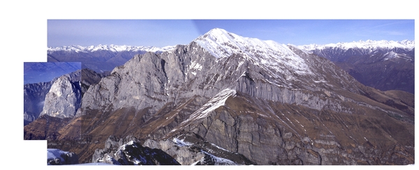
Figure 21. The margin of the Grigna Settentrionale carbonate platform.
The Esino Fm. builds the walls in which the clinoforms merge to the SE (from left to right in the picture) to eventually interfinger with the basinal units of Buchenstein and Wengen fms. (Photo M. Gaetani).
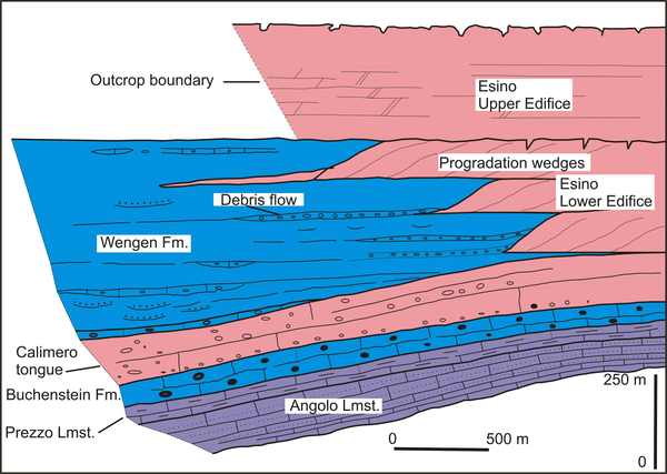
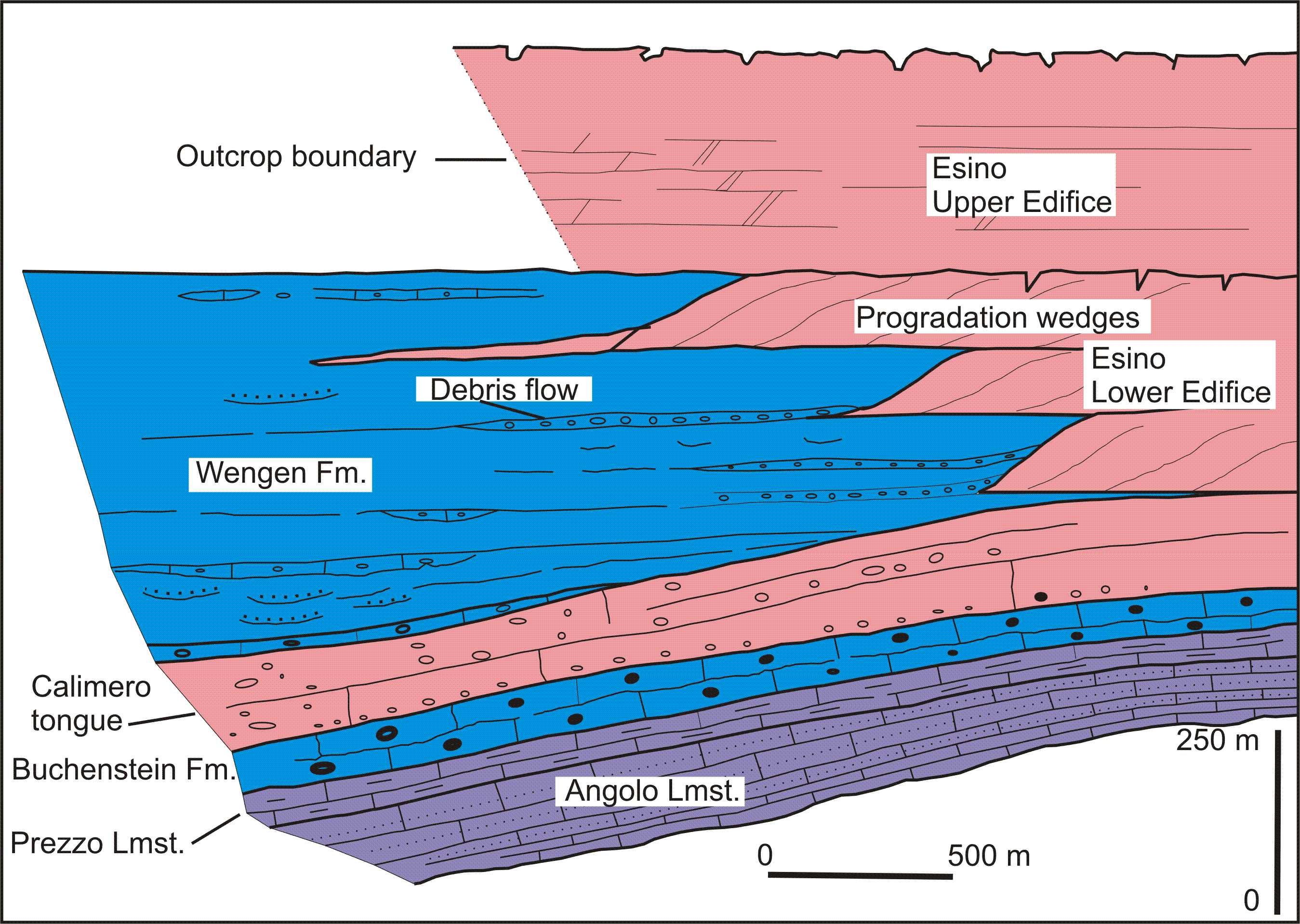
Figure 22. Platform vs basin relationship.
Example of complex interfingering between carbonate platform and basin; north side of the Prabello through (Grigna Settentrionale) (redrawn and modified from Gaetani et al., 1998). The Angolo + Prezzo lmsts. represent a bay environment, deepening during the upper Anisian. The Buchenstein + Wengen fms. represent the basin on which the Esino platforms prograded. The Calimero tongue was partly a progradation and partly a huge megabreccia body, entirely consisting of carbonate debris.
In the Dolomites are the best-studied examples and the literature on this topic is very ample (Bosellini and Rossi, 1974; Gaetani et al., 1981; De Zanche et al., 1995; Gianolla et al., 1998; Maurer, 2000; Blendinger, 2001; Keim and Brandner, 2001; Caputo and Stefani, 2002; Bosellini et al., 2003; Stefani et al., 2010; among others) (Fig. 23). Due to the pervasive diagenetic dolomitization, often microfacies of the margins are not preserved, but study of the blocks fallen along the slope and embedded in the basinal rocks may allow comprehension of the organism communities building the banks and platforms. A basic feature is the scanty presence of corals. The platforms are mostly the product of algal and microproblematic activity, like Tubiphytes. Early cementation is the device that allowed the formation of growing steeper slopes. For full discussion on this point, see Stefani et al. (2010) (Fig. 24).
Figure 23. Style of interfingering.
The style of interfingering in the lower edifices in western Dolomites. Especially in the Latemar Group, the presence of ammonoids also on the platform allowed to better constrain the parallelization platform/basin (from Manfrin et al., 2005 modified).
Figure 24. Palaeogeography at the Anisian/Ladinian boundary.

The distribution (not palinspastic) of platforms and basin in Dolomites around the Anisian/Ladinian boundary.
Top. 1. Carbonate platforms, 2. pelagic plateau or carbonate banks sunken in the lower Ladinian; 3. Basins. 4. Alpine faults truncating carbonate banks. 5. Ore deposits. (From Assereto et al., 1977).
Bottom. The extension of the lower edifice of the carbonate platforms. (From De Zanche et al. 1995).
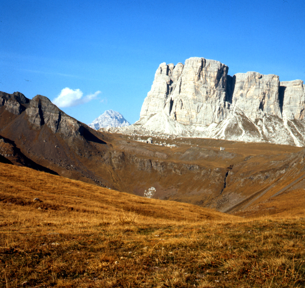
From a palaeogeographic point of view, a wide and deep embayment flanked by carbonate platforms developed in the Cadore area of the Eastern Dolomites. It was open to the south because it received the turbiditic currents with reworked volcanics and siliciclastic material of the Zoppè Sandstone (Viel, 1979). Wide lobes of this major basin penetrated westwards, separating the carbonate banks or protruding platforms from the persistent shallow-water area with carbonate production in the westernmost part of the Dolomites (Fig. 25).
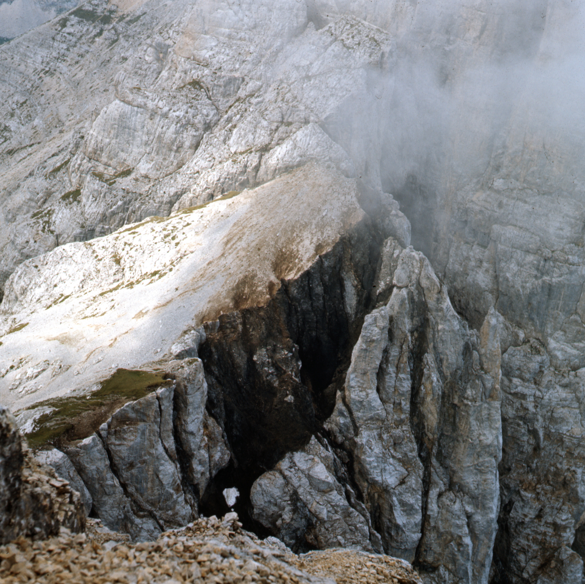
Figure 25. The slope of the Cernera Bank.

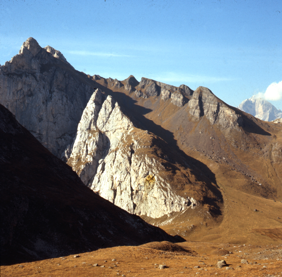
An example of the slope of the Anisian/Ladinian carbonate bank. The Cernera margin toward the North. Note the angular unconformity sealing the paleoslope indicating the original steepness of the bank margin. (Photo M. Gaetani).
Some of these margins are interpreted as being guided by active faults (Doglioni, 1987).
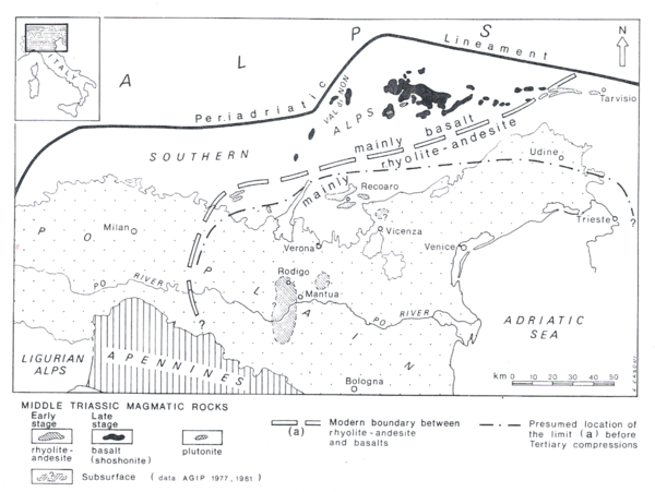
Associated with the increasing of the crustal instability is the first onset of the volcanism. Most typical for this time are tuffs and in general explosive products in outcrop. Rarer are the feeding dykes and magmatic bodies. They are cropping out in Eastern Lombardy (Cassinis and Zezza, 1982) and in the Recoaro area (Barbieri et al., 1980). The most typical products are the so-called “Pietra Verde” consisting of green tuffs with lapillistone, frequently reworked and displaced in the deepest part of the basin by turbidity currents. Being present from western Lombardy and Ticino until the Carnia, they reach a maximum thickness of some hundreds of m in the basin of the Eastern Dolomites, reworked and accumulated from the sources situated to the south (Bosellini et al., 2003). The Recoaro area was a site for the effusion, but other sources should be situated below the Venetian plain and detected by commercial boreholes (Brusca et al., 1982; Castellarin et al., 1988) (Fig. 26).
Figure 26. Magmatism in Southern Alps.
The magmatic rock distribution in the Southern Alps during the Middle Triassic and the Carnian. Note that volcaniclastics fed alluvial and submarine fans also in central Lombardy and the tephra arrived to the western Lombardy (From Castellarin et al., 1988, modified).
The late Ladinian
During the upper part of the Ladinian, two main settings developed in the Southern Alps. In Lombardy and Carnia, a development of the carbonate platforms coupled to basins continued. Often no distinction with the platform may be made and consequently, from the nomenclatural point of view, a single term like Esino or Schlern is adopted for the whole platform (Gaetani et al., 1992; Jadoul et al., 1993; Jadoul and Nicora, 1986). In the basins the major difference in comparison to the lower Ladinian was the passage from the cherty limestone of the Buchenstein Fm. to more silty units, fed mostly from the south (Brusca et al., 1982).
In the Dolomites, by contrast, geologic evolution and setting are more complicated, with the most important event being the intrusion of a magmatic dome in the area of Predazzo (Doglioni, 1983; Castellarin et al., 1988). An aureole of dykes is spread all around, cutting the carbonate platform bodies as in the Latemar Group (Fig. 27). Other volcanic activity occurred in the south, under the Venetian and Po plains. Doming stopped the growth of the platforms in the Western Dolomites, and most of them emerged or, due to the reduced accommodation, resulted in less thick carbonate bodies. Dismantling of the volcanic products generously fed the basins with chaotic accumulations, conglomerates, and more organized turbiditic bodies (Viel, 1979) (Fig. 28). Gradually, the paroxistic magmatic activity stopped and the carbonate platforms that continued to grow far from the polluting centres recovered (Fig. 29).
Figure 27. Volcanic dykes in the Latemar.

In the Latemar Group, the volcanic dike dissect the carbonatic platform. Saddle to the north-west of the Cornon del Latemar. (Photo M. Gaetani).
Figure 28. Volcanics in Dolomites.
The dismantling of the volcanics in the western Dolomites brought a great amount of material in the basin of eastern Dolomites. Top. Relationships between the major units. Bottom. Paleogeographic (not palinspastic) map the major submarine fans. (From Viel, 1979).
Figure 29. Recovering of the carbonate platform.

With the demise of the volcanic activity and filling of large part the basins, the carbonate platforms were able to prograde and a new set of platform established since the latest Ladinian through part of the Carnian. The Lastoni di Formin Cassian platform prograded on the volcaniclastics of the Wengen Group. (Photo M. Gaetani).
Magmatic products moved from the mainly rhyolite-andesitic signature to a basaltic shoshonitic nature. The calc-alkaline trend toward more basic products is coupled with a shifting of effusion centres to the NNW in present coordinates (Castellarin et al., 1988) (Fig. 26). The shifting in time and space of the volcanic sources suggests the existence of a source moving deeper toward the NW. Several geochemical indexes point to a volcanic arc of basalts for the upper Ladinian magmas. To discuss the general geodynamic scenario is out of the scope of the present review, but it should be stressed that up to now a very convincing reconstruction has yet to be proposed because of contradictory evidence affecting the general settings of the margins of Adria and the Balkan areas. The system Palaeo-Tethys vs. Neo-Tethys is better understood eastwards (see Barrier and Vrielynck, 2008). Details on the pivotal point(s) to the margin of Adria are instead controversial.
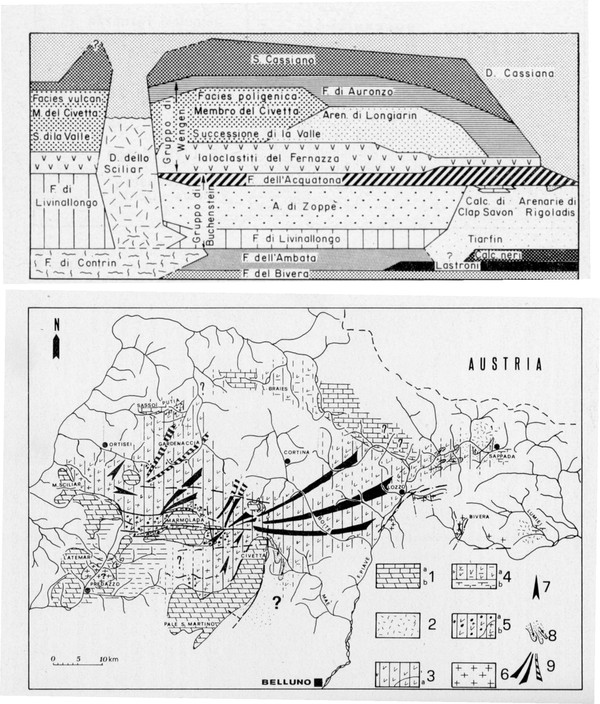
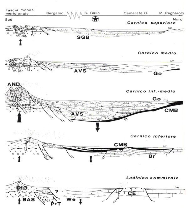
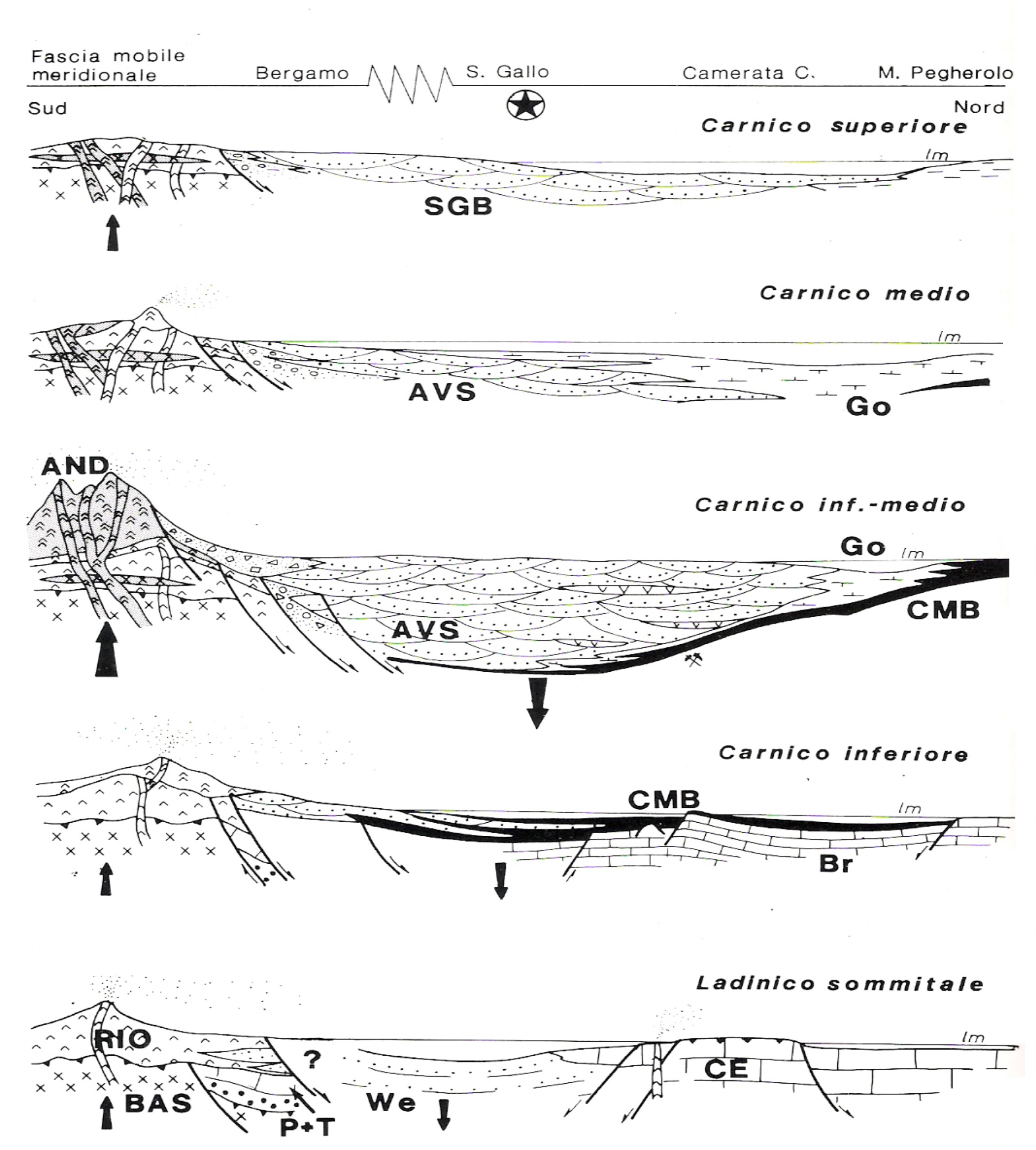
In Carnia, the Alpine tectonics dismembered the original paleogeographic pattern. However, a basinal area may be recognized to the west, while the carbonate platform was persistent to the east (Jadoul and Nicora, 1985; Jadoul et al., 2002) (Fig. 30).
Figure 30. Ladinian units in Carnia.
Stratigraphic scheme for the Ladinian units in Carnia region. The deeper areas are developed to the west. (From Jadoul et al. 2002).
The Carnian
The last act of the very complex evolution of the Southern Alps during the time interval under examination was characterized by gradual reduction in tectonic activity and subsidence rate. The volcanism was no more active in the Dolomites, but moved to the SW, with a volcanic arc located to the south of the Lombardian Prealps, and with a few apparatuses cropping out near Brescia. This last cycle started after the global eustatic sea-level lowering, which occurred during the topmost Ladinian.
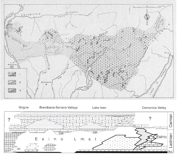
In Lombardy, veneers of peritidal/subtidal, mostly micritic carbonates, are spread over large parts of the area, except for a few basins that are not completely filled by the fine clastics of the Wengen Fm., as in Valcamonica and Giudicarie (Balini et al., 2000). In the southern parts of the outcrops and below the sole of the alpine thrust sheets, these carbonatic bodies were cut and covered by a volcanic arc, spread from Lecco to Recoaro for some 150 km, whose material was dismantled and transported northwards to form three major aprons (Val Sabbia Sandstone) (Fig. 31).
Figure 31. The Valsabbia volcaniclastic fans.
The volcaniclastics originating from the dismantling of the volcanic arc situated to the SW of the present Bergamo and Brescia Prealps, formed three major subaerial fans, submarine in their distal part. In the Brescia province also some volcanic apparatuses are preserved (From Garzanti and Pagni Frette, 1991, redrawn). Not palinspastic.
The aprons were partially submarine to the north, where they interfingered with the lagoon of the Gorno Fm. (grey, dark, marly limestone with oligotypic mollusc fauna) (Fig. 32). In turn, the lagoon interfingered with the peritidal carbonates of the Breno Fm. The geochemical signature suggests linking these volcanics to a back arc magmatism (Garzanti, 1985; Cassinis et al., 2008). After a last pulse of volcanic eruptions late in the Carnian, a wide, mixed evaporitic, flat with red and green shale, covered the whole area, in a setting of playas with a low subsidence rate.
Figure 32. Evolution of the Carnian back-arc.
Evolution of the Carnian back-arc in Central Lombardy along a N-S transect. To the North of Bergamo data from outcrops. To the South, the interpretation is based on few borehole and mainly on clastic analysis of the terrigenous fans. (From Garzanti and Jadoul, 1985).
In the Dolomites, the situation was still more complex. When the volcanic activity was over, carbonatic bodies recovered on the previously non-emergent areas of the Western Dolomites and to the northern fringe of the Eastern Dolomites. Reef builders evolved to more diversified patterns, with colonial scleractinians making their first important appearance together with calcareous sponges (Dieci et al., 1970; Zardini, 1973, 1978). Algae and sponges also became important. Where subsidence persisted at a higher level, several superposed tongues of the platforms prograded toward the basin. Since the basins had been previously largely filled by volcanogenic material, progradation was easier, and the platforms progressively merged (Cassian 1 and 2 platforms). Stefani et al. (2010) examined in detail the climatic control of the evolution, stressing the importance of the arid-to-moist climatic oscillations. The increasing influence of moist episodes helped in producing siliciclastics that reached the smaller remaining basins. Carbonate productivity still formed carbonate ramps and coral patch reefs that sealed the succession in the Eastern Dolomites before the emersion of the area, producing a flat topography (Stefani et al., 2010). Red silty-to-shaly units mark the end of the complex cycles characterizing the Dolomites (Fig. 33).
Figure 33. Red shales sealing the sedimentary cycle.
The end of the cycle is marked by red siltstone and shale, with few dolostone intercalations. Moiazza Group, loc. Col dell’Orso, Belluno Province (Photo M. Gaetani).
In Carnia, the persistent carbonate platform, often dolomitized, had its maximum development toward the top of the Ladinian. This platform was dismembered by syngenetic movements in the earliest Carnian (dating is uncertain) (Jadoul and Nicora, 1985; Krainer and Lutz, 1995). Isolated small basins, fed by the micrite produced on the still-living carbonate banks, remained in a few areas (Malborghetto). Later, most of the area was covered by lagoonal micrite and clays. The classical succession of Cave del Predil/Raibl is within this interval (De Zanche et al., 2000; Gianolla et al., 2003). Also in that region, the demise of the reef-builder communities and consequent crisis in the carbonate productivity led to almost a filling of the previous basins. What is peculiar to the Tarvisio area is the possibility of fairly good dating of the demise of the previous settings and the ongoing of a new style of carbonate production and general setting (Gianolla et al., 2003). The ongoing of the Dolomia Principale type of platforms and peritidal flats may be dated to the late Carnian, while on most of the Southern Alps dating is poor or emergent areas with playas were dominating (Fig. 34).
Figure 34. Transition to the new story.
In the Raibl area it is possible to date the onsetting of the Dolomia Principale, in the latest Carnian (From Gianolla et al., 2003, modified).
The Ionian Triassic
In Southern Italy, in the area of the seaway that had already opened in the Permian, a different evolution occurred. Two regions are significant.
Sicily
In western Sicily, a succession of troughs and swells has been recognized since the 1960s. Studies were done first by petroleum geologists (Schmidt di Friedberg, 1960), with academic studies following (Mascle, 1967; Catalano and d’Argenio, 1978; Montanari, 1987; Catalano et al., 1991, 1992). From north to south in the present orientation they are: Panormide Platform/Imerese Basin/Trapanese Swell/Sicanian Basin/Sciacca Swell/Iblean Platform. Full separation of these paleogeographic elements has occurred since the latest Carnian (Di Stefano, 1990). The stratigraphy and sedimentology of the Triassic sediments in these paleogeographic and structural elements have been thoroughly discussed in several papers (Di Stefano, 1990; Catalano et al., 1992, Bellanca et al., 1995; Gullo, 1996; among others).
As previously mentioned, the Lercara Formation contains intrabasinal (carbonate and shales) and extrabasinal components (clayey sandstones, quartz, and feldspars). Among the numerous group of fossils there is evidence for many Permian stages and Early Triassic to Anisian in the Triassic (Gullo,1993; Carcione, 2007).
On these rocks lays, with tectonic contact, the Mufara Fm., which is in turn overlain, mostly with tectonic contact, by the cherty limestones of the late Carnian-Rhaetian age. The Mufara Fm. consists of fine siliciclastics, marls, and shales, with calcarenite intercalations (Di Stefano, 1990; Distefano et al., 1998; Carrillat and Martini, 2009). It is known in the Panormide, Imerese, and Sicano domains, where it is bounded to the Carnian, while in the Trapanese domain it is late Ladinian/early Carnian in age (Buratti and Carrillat, 2002; Carillat and Martini, 2009). It is also known near Catania at M. Judica (Lentini, 1974). The carbonate debris intercalated within the Mufara Fm. should indicate that the carbonate skeletal grains derive from coralline sponge and Spongiostromata patch reef communities located on a distally steepened shelf or ramp (Carillat and Martini, 2009).
During the late Carnian, terrigenous sedimentation was over on the entire basinal areas of Sicily, and sedimentation was dominated by calcilutites, resulting in a well-bedded mudstone with cherts, rich in halobiids, conodonts, radiolarians, and a few ammonoids. Due to its rich fossil content and physical stratigraphy (palaeomagnetism and isotope stratigraphy), the Pizzo Mondello section is presently proposed as the GSSP of the Carnian/Norian boundary (Nicora et al., 2007). On the carbonate platforms and in the slope breccias, nice reef-builder organisms are described (Senowbari-Daryan et al., 1982).
Lagonegro
Severe deformations affect the Triassic succession of the Lagonegro area in the Basilicata region, especially its lower part. However, since the first synthesis of Scandone (1967), detailed field researches have reconstructed the succession (Ciarapica et al., 1990; Panzanelli Fratoni, 1991; Ciarapica and Passeri, 2005; and ref. therein). The basal unit is represented by the Monte Facito Fm., a comprehensive unit including up to 10 different lithofacies (Passeri and Ciarapica, 2010). Besides the shallow-water blocks with Permian microfauna, it records deeper-water evidence (shales and calcarenites) for part of the Lower Triassic, and also both shallow-water massive carbonates and shales and radiolarites, which are assumed to be lateral equivalents during most of the Middle Triassic. Toward the top of the Ladinian, a general drowning spread the radiolarites over the whole area, sealing the previously more-articulated setting (Fig. 35). With the beginning of the Late Triassic, an homogeneous sedimentation dominated by thin-bedded, light cherty limestones continued, with an average sedimentation rate (non-decompacted) around 10–20 m/My. Limy sedimentation went to an end toward the top of the Triassic, when siliceous shales, with occasional layers of calcarenites, prevailed, forming the record for the whole successive Jurassic.
Figure 35. Comprehensive successions of the Lagonegro area.

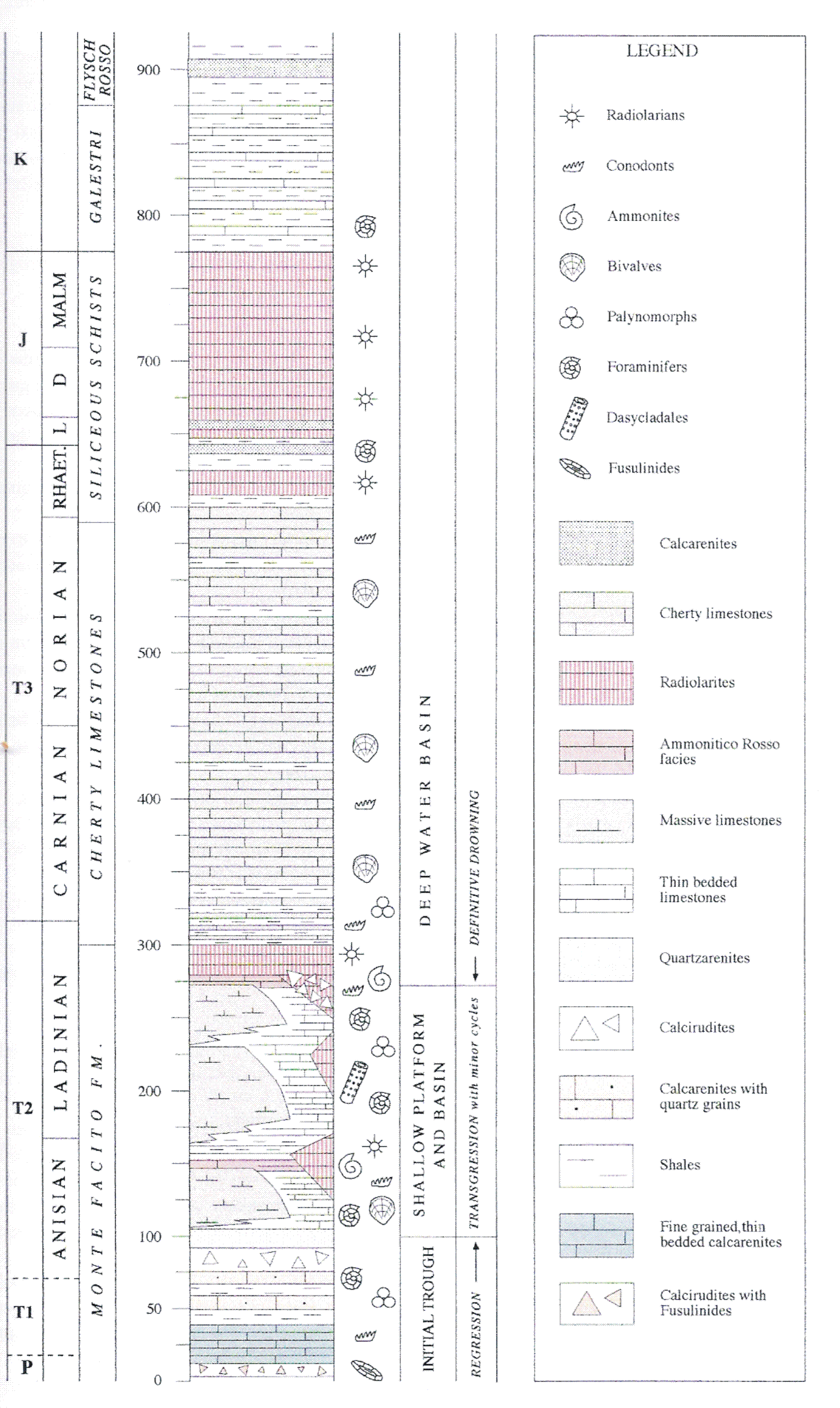
Note the definite down-warping toward the end of the Ladinian. The pelagic conditions will persist for the whole Upper Triassic and Jurassic. (From Ciarapica and Passeri, 2005, simplified).
Discussion
There is no doubt that since the Permian a deep marine trench was open in Southern Italy, bordered by carbonate reefs and banks. Fine siliciclastics fed the trench in which landslides repeatedly displaced fragments of the shallow-water carbonates. This setting continued at least up to the Ladinian, both in Sicily and in the Lagonegro area. Syntectonic activity decreased in the Ladinian, ending in the Lagonegro, while it continued in Sicily, though gradually reducing, during the early Carnian. With the late Carnian it was over also in Sicily and steady pelagic carbonate/cherty sedimentation spread everywhere in the basins. The rather high sedimentation rate suggests the importance of the nearby carbonate platforms as producers of micrite to be exported in the basins, even if the evolution of the first coccolitophorides algae may add a significant new producer to the carbonate factory, within the pelagic context itself, since the Ladinian-Carnian (Erba, 2006).
The geodynamic interpretation may suggest that during the interval—Permian to Middle Triassic—the trenches were activated by the rifting tectonics, and later, in the Late Triassic, the thermal subsidence was the greatest driving force. Reconstructions of the Ionian Sea (Catalano et al., 2001; Finetti, 2005b) suggest that the main trench was continuing below what is now the Calabrian arc, while the basin and swell system of Sicily was a lateral branch connected to the main basin.