Propagation of the Atlantic Rifting
Around the Carnian-Norian boundary, a totally new setting was emerging at the northwestern margin of Adria (Fig. 36). A rifting was starting in the Central Atlantic in the Ladinian-Carnian, according to ages obtained in the Moroccan rifted basins (Baudon et al., 2009), eventually giving way to the large basalt outpouring of the Central Atlantic Magmatic Province (CAMP) (Marzoli et al., 1999; Cirilli et al., 2009). This rifting system propagated eastwards and controlled the structural evolution and sedimentation, both in the Southern Alps and the Apennines, in the time interval Norian to Middle Jurassic. We may divide this interval into three parts: first, a Late Triassic section, followed by an Hettangian-basal Toarcian step, and then a third phase Toarcian-Aalenian in age. It is important to note that rifting and later the opening of an oceanic seaway contoured Adria around its northern margin, instead to join directly the already opened Ionian trench, and the Sicilian basins. Should this rifting have directly joined the Ionian trench, this last should have reached a much larger width than the actual 330 km calculated by Catalano et al. (2001). Also, if Ionian was already an ocean, why the propagating rifting didn't joined the already existing weakness in the crust?
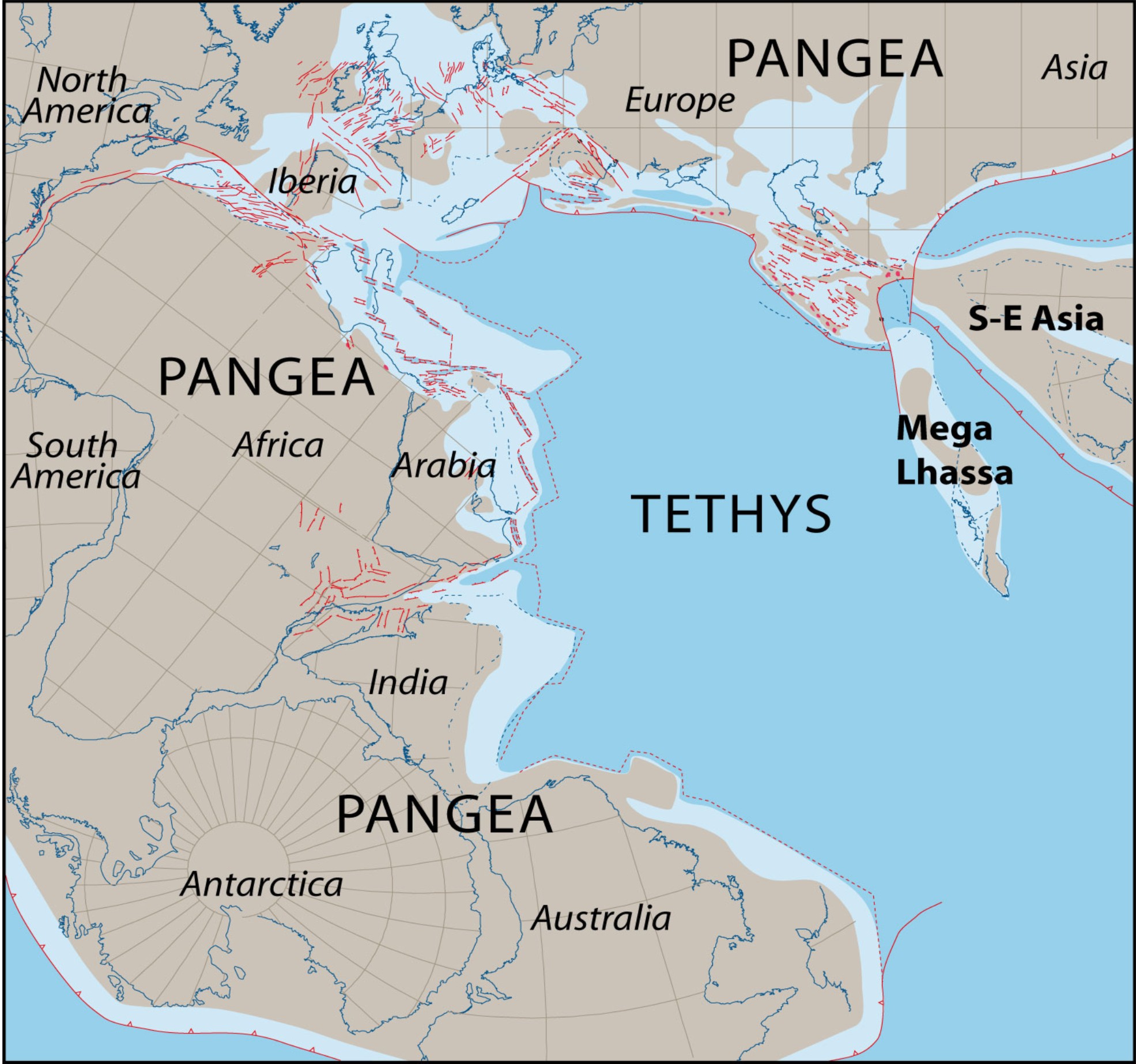
Figure 36. Central Atlantic rifting.
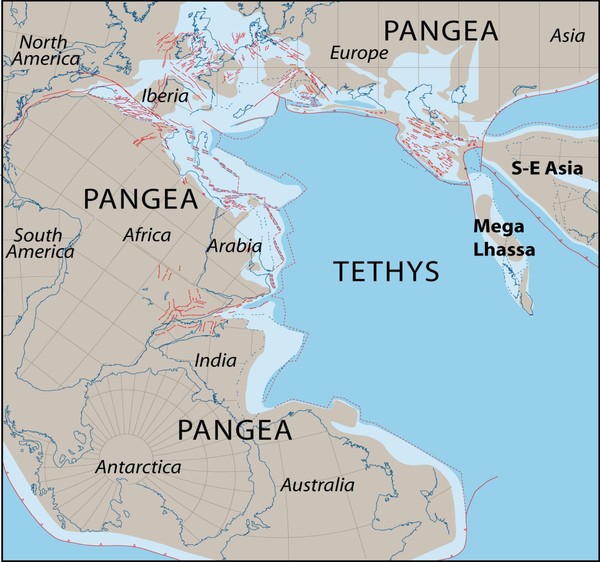
The rifting in the place of the future Central Atlantic Ocean started to propagate eastwards during the Norian, turning around Adria, still an African Promontory. (From Barrier and Vrielynck, 2008).
The Late Triassic first stage of rifting
I will discuss only the Southern Alps evidence because of their better-preserved relationships. For a review of the Apenninic evolution during this time refer to Ciarapica (2007). The new cycle started everywhere with deposition of the Dolomia Principale, a very thick composite unit, consisting of thick-bedded peritidal dolostone mainly deposed under arid conditions due to the tropical latitudes in which Adria was laying at that time. This wide peritidal platform might have a modern counterpart on the Arabic side of the Gulf. Dolomitization was due to early diagenesis and represents a huge sequestration of Mg from the sea waters, the last massive Mg storage in the Earth’s history. The Dolomia Principale facies (the Haupt Dolomit of German authors) extends from the Betic Range in Spain as far as the Himalayas (India and Tibet). It might also be considered a typical Tethyan facies. However, the subsidence patterns in the Southern Alps are already driven by rifting linked to the Central Atlantic rifting. In fact, in Lombardy the most subsiding areas are the same as the Early Jurassic. The subsidence rate may be 1:3, paleohighs vs. troughs, with rates exceeding 100 m/My in the basins. In the more subsiding areas, significant facies differentiation occurred in the middle/upper part of the Dolomia Principale, when slightly deeper basins individuated within the carbonate platforms (Aralalta Group). Thin-bedded mudstone with interbedded calciruditic and calcarenitic layers formed at the bottom of basins often in disoxic to anoxic conditions. This allowed the preservation of a unique vertebrate fauna, mostly with fishes, but including the more ancient pterosaurians (Fig. 37). On the shoulders of the basins, the peritidal carbonates continued to develop, even with a lower sedimentation rate (Fig. 38). The platform margins are sometimes preserved with a rim built mostly by encrusting algae and microbialite, after a significant demise of the coral frame builders. Slopes may be locally preserved as in Lombardy (S. Martino di Griante: Gaetani et al., 1987; Artavaggio: Jadoul, 1986; Jadoul et al., 1992) and in Carnia (Cave del Predil: De Zanche et al., 2000). The same pattern with interplatform anoxic to disoxic basins has been also recognized in Friuli (Scotti et al., 2002) where the Dolomia di Forni, the lateral equivalent of the Dolomia Principale, also contains significant terrestrial vertebrate fauna, including pterosaurians (Dalla Vecchia, 2002) (Fig. 39).
Figure 37. Early flying reptile.
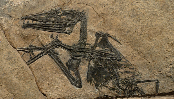
Eudimorphodon ranzii, a flying reptile from the Zorzino Limestone (middle Norian), one of the most ancient flying reptiles so far known.
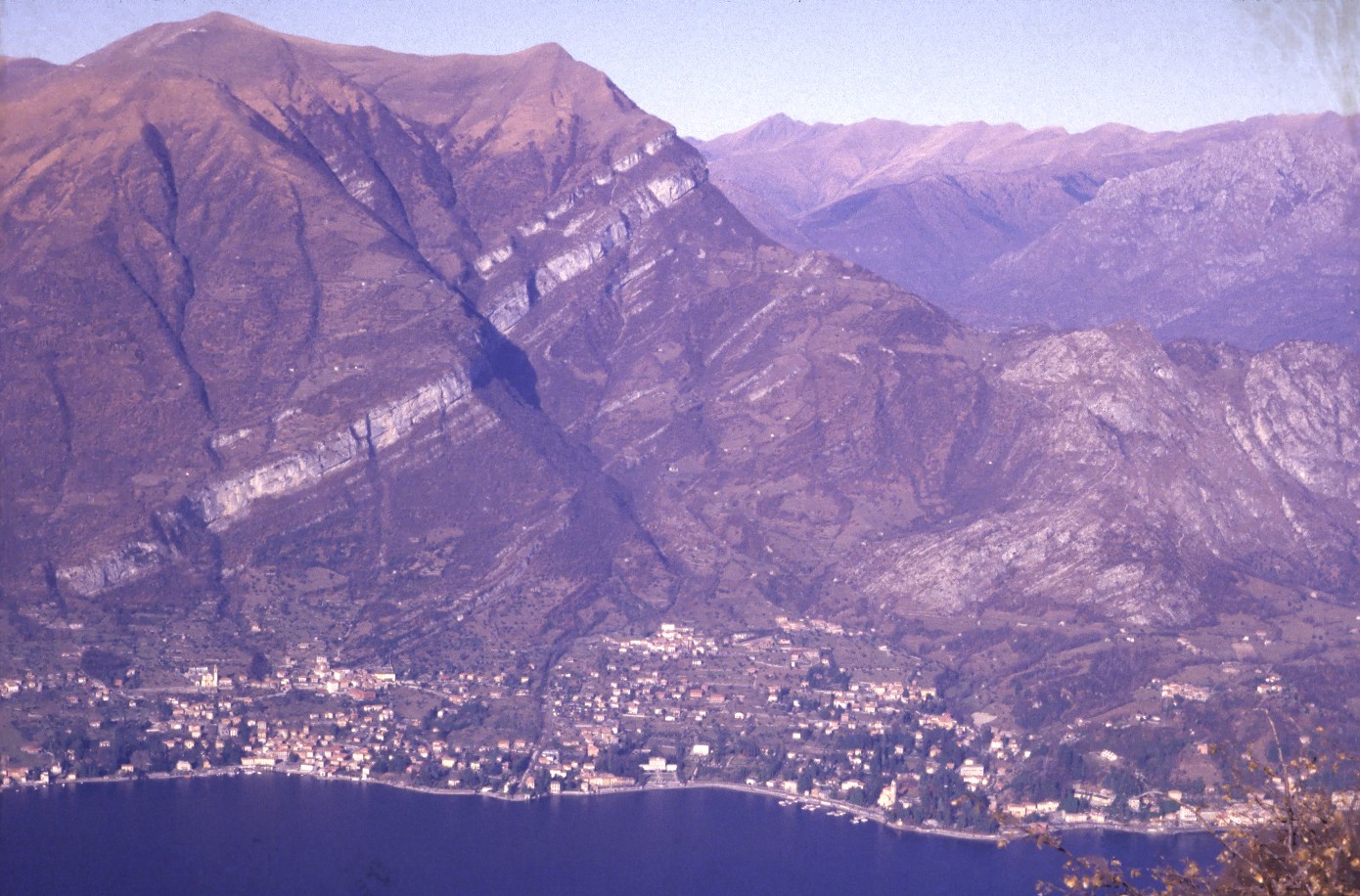
Figure 38. Upper Triassic-Lower Jurassic succession.

The Norian - Sinemurian succession near Cadenabbia (Como Lake). To the right the Dolomia Principale is overlain by the softer shale, marl and limestone succession of the upper Norian-Rhaetian, in turn overlain by the cornice formed by the Albenza Fm. (formerly Conchodon Dolomite) of Hettangian age. The prairies of the Calbiga Mnt., on the upper left, cover Moltrasio Limestone, the major infilling of the Generoso Trough. (Photo M. Gaetani).
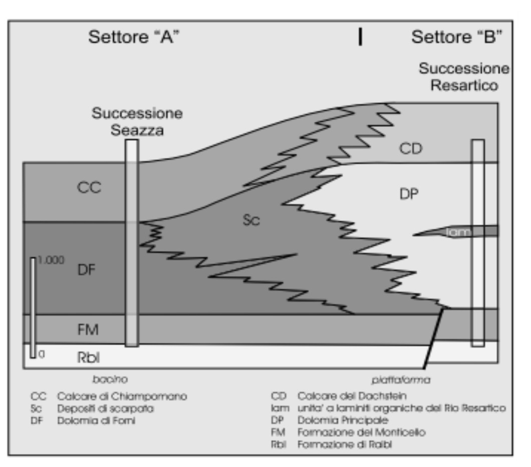
Figure 39. Platform vs basin.

Relationships between the plaform (Dolomia Principale + Calcare del Dachstein) and the basinal facies (Dolomia di Forni + Calcare di Chiampomano). (From Scotti et al., 2002)
Toward the end of the middle Norian, a new pulse in the rifting, coupled with an increase of humidity because of the drifting of Africa northwards—thus pushing Adria toward more temperate latitudes (Muttoni et al., 2005)—caused the input in the basins of a huge amount of clay. It resulted in the deposition of the Argillite di Riva di Solto Formation (Fig. 40). The high accommodation rate was allowed by the extensional regime, continuing the separation of basins from the swells, allowed by direct syngenetic faults (Jadoul et al., 2008). The amount of clay is much reduced in Friuli and absent in the Dolomites, even if in the eastern Dolomites the thickness of the Dolomia Principale is very high (up to 2000 m) but encompasses the whole Norian and probably the Rhaetian (Fig. 41). With the beginning of the Rhaetian, this first rifting episode gradually vanished, and the Calcare di Zu Fm., a mixed shale/mudstone unit, extended in Lombardy also on some of the swells not previously attained by the clays of the Riva di Solto (Fig. 40). The gradual decrease of the clay input allowed the recovering of colonial corals forming one or two fairly continuous banks (Fantini Sestini, 1990). Recent findings of conodonts allow dating more precise than was previously possible (Rigo et al., 2009; Muttoni et al., 2010). By the end of the Triassic, this first rifting pulse was over, and the Triassic/Jurassic boundary may be recognized only in central Lombardy (Jadoul et al., 2008). Due to the biocalcification crisis, fossils are scanty and the boundary is recognized on a palynological basis (Galli et al., 2007).
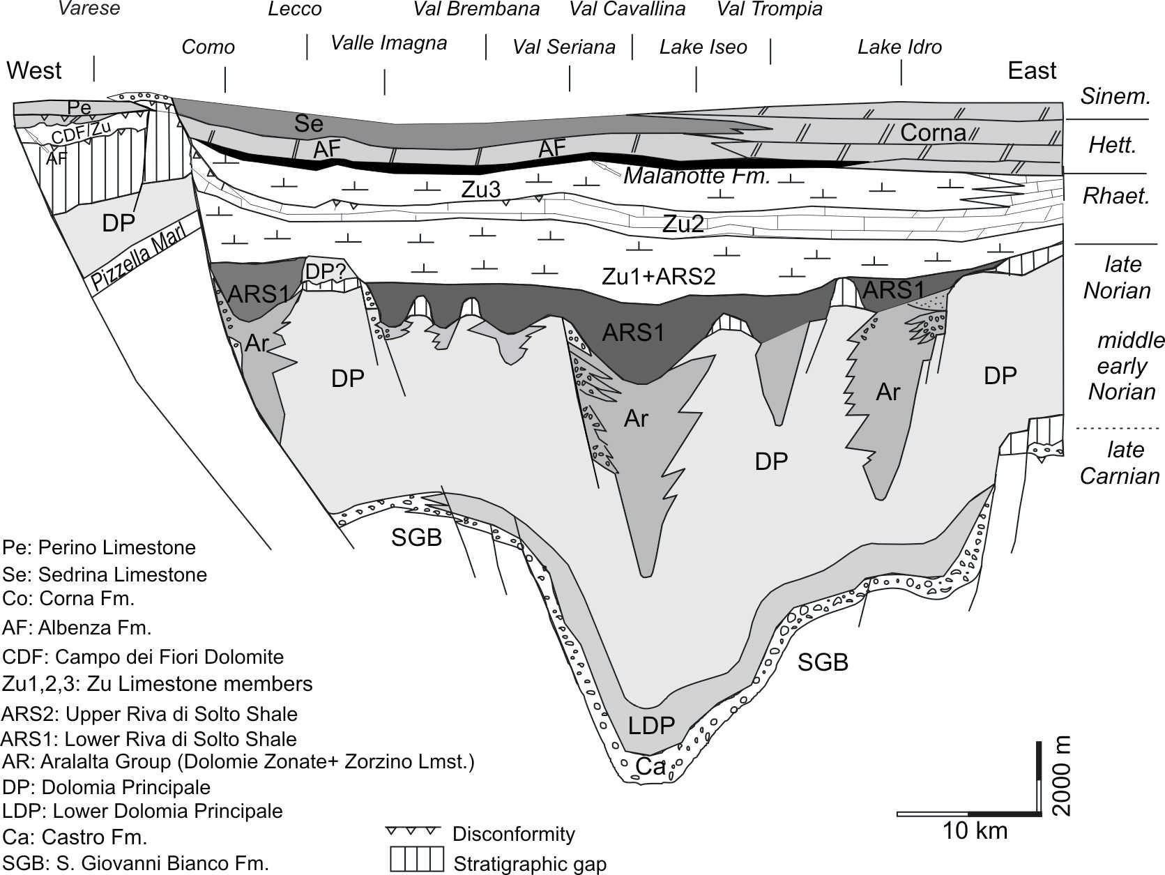
Figure 40. Norian to Hettangian in Lombardy.

Stratigraphic scheme for the Norian to Hettangian in the central part of the Lombardian Basin. The scheme considers both thickness and time, thus also the gaps have a temporal expression. (From Jadoul et al., 2008).
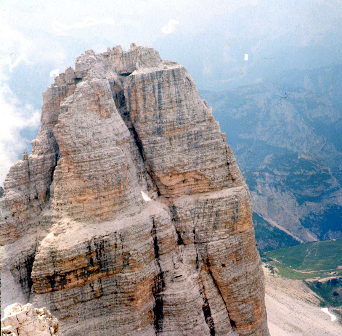
Figure 41. Peritidal cycles in the Dolomia Principale.

The dolostones of the Dolomia Principale form typical peritidal cycles. Upper walls of the Cima Ovest di Lavaredo. (Photo M. Gaetani).
In the eastern Lombardy and western Trento area, the clay input was reduced, and only the Calcare di Zu and local equivalents developed, overlying the Dolomia Principale. In the Dolomites this unit may be very reduced in thickness—200 m in the Sella group—(Bosellini, 1967). No equivalent of the shaly Norian-Rhaetian units are known here (Fig. 42). To the east in Carnian and Julian Alps, a more calcareous unit interfingers or overlies the Dolomia Principale, the Dachstein Limestone (De Zanche et al., 2000; Piano and Carulli, 2002).
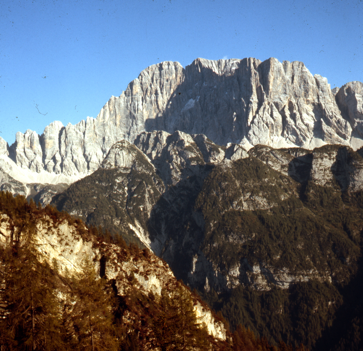
Figure 42. The wall of the walls.

The Dolomia Principale is overlain by the Liassic limestone of the Calcari Grigi, without any erosional ledge corresponding to Upper Triassic clay input. The Calcari Grigi start where the wall became fully vertical. West wall of the Civetta Mnt. (Belluno Province). The wooded wall in front is made of the Middle Triassic Sciliar Dolomite.(Photo M. Gaetani).
The Late Triassic palaeogeography partly reproduces settings previously already present, as some basins were active where they were already in the Middle Triassic in central Lombardy. However, palaeogeography mainly evolves along new lineaments, prevailing N-S oriented. The W-E orientation of the depositional features in Lombardy and in Carnia, and to a minor extent in the Venetian Alps, is not continued, and the new orientation suggests the linking to an extensional area active to the north and to the west. Bertotti et al. (1993) evaluated in detail the amount of extension originated from this stretching.
The Early Jurassic, second phase of rifting
After the pioneering Ph.D. theses of F. Wiedenmayer (1963) and D. Bernoulli (1964), and subsequent papers (Bosellini, 1973; Gaetani, 1975; Bernoulli et al., 1979; Winterer and Bosellini, 1981; Weissert and Bernoulli, 1985; Sarti et al., 1992; Bertotti et al., 1993; among others) it appeared possible to describe the Jurassic evolution of the Southern Alps in terms of a passive margin facing a rifting and subsequently spreading oceanic area positioned to the west and to the NW.
In the Central Apennines especially, similar facies are present with timing in rifting and drowning comparable to the Southern Alps (Bosellini, 1973) indicating that also in that area the evolution of the passive margin may be studied, even if geometrical relationships are less preserved.
In the Southern Alps, fragments of the rim of the passive margin are poorly exposed in the Canavese area (Sturani, 1973). Better exposures are in the Swiss Alps (Trümpy 1960; Weissert and Bernoulli, 1985; Manatschal and Bernoulli, 1999) or more scanty in the Ligurids nappes (Marroni and Pandolfi, 2007) (Fig. 43).
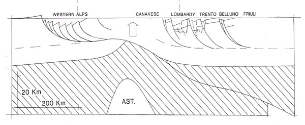
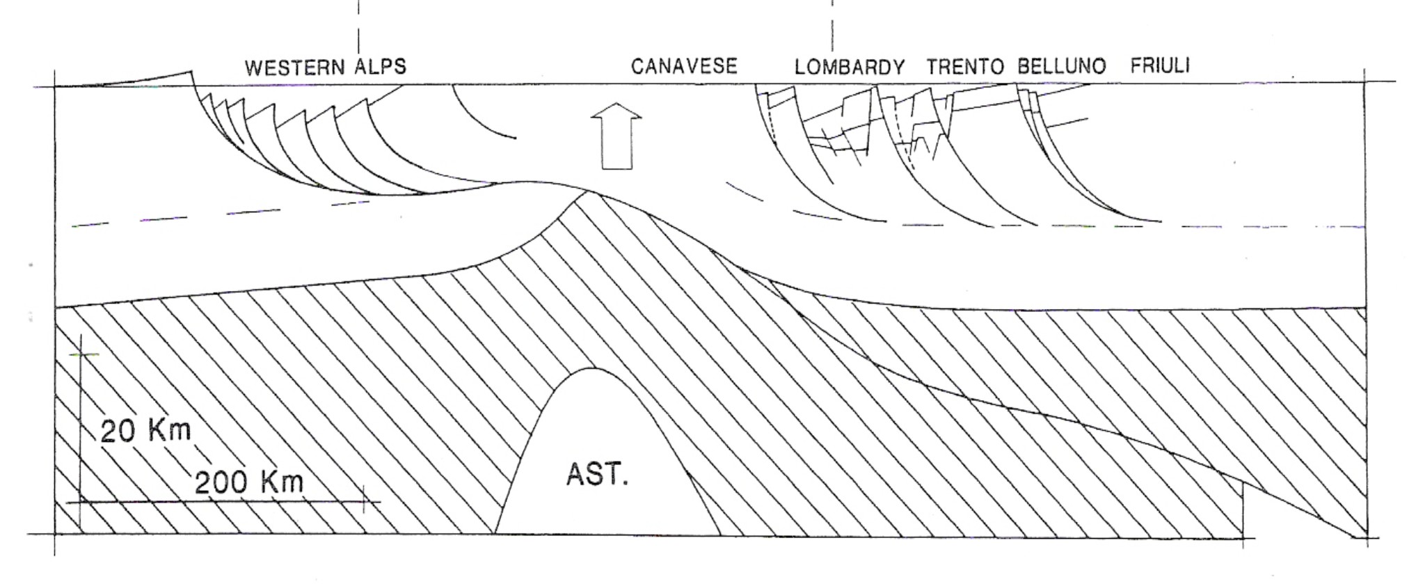
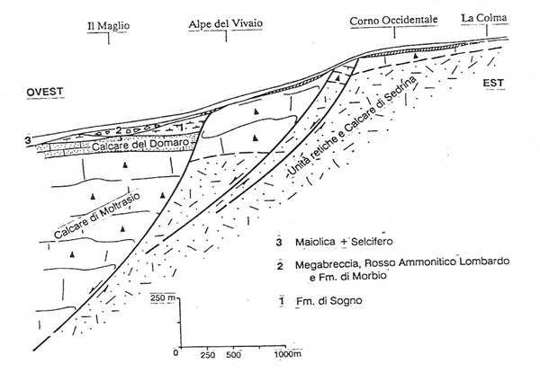
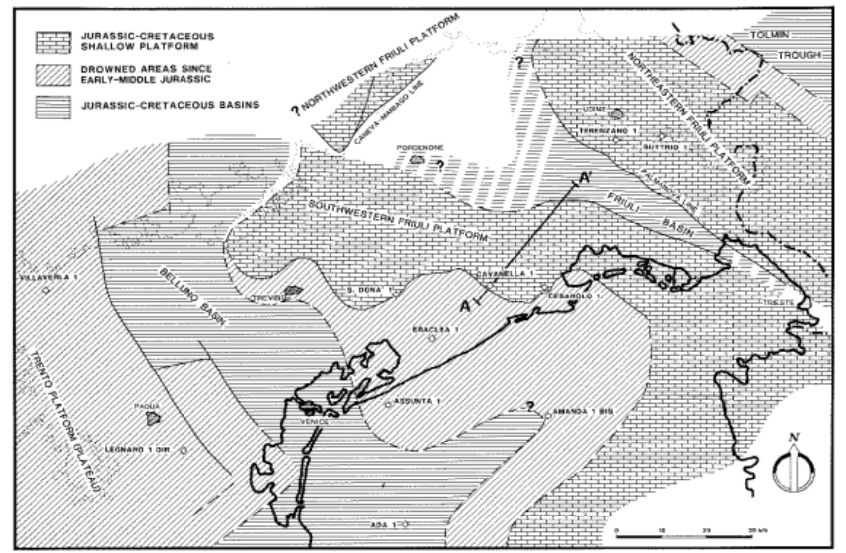
Moving from west to east, five main paleogeographic elements may be distinguished: the Canavese and Biella Zone, the Lombardian Basin, the Trento Plateau, the Belluno Basin, and the Friuli Platform. The basins are activated by direct faults mainly along a pattern of half-graben system, with the more subsiding part to the west, suggesting that the evolution of the margin was according to the “simple shear” model (Sarti et al., 1992) (Fig. 44). However, Bertotti et al. (1993) consider that there are not yet sufficient data to support this interpretation.
Figure 44. Simple shear extension.
The Adria margin evolved according to the “simple shear” model in the Sarti et al. (1992) interpretation, along a half-graben system in the Southern Alps.
The successions of the Canavese/Biella Zone are reduced in thickness and poorly exposed. Its hinge with the Lombardian Basin is fixed at the Gozzano High. Within the Lombardian Basin itself, starting with the late Hettangian or the early Sinemurian, a number of troughs and swells or paleohighs were individuated. West to east, they are: M. Nudo Trough/Arbostora High/Generoso Trough/Corni di Canzo Swell/Albenza Trough/M. Cavallo-Zandobbio High/Sebino Trough/Botticino Dome. They end against the Trento Plateau with the Garda Escarpment. Due to the outcrops aligned along a belt roughly W-E oriented, the N-S relationships are lesser known. Troughs are some 20–30 km wide and swells or palaeohighs are a few km in width. Because the carbonatic backbone of the paleohighs acted as a trap and reservoir for hydrocarbons originating from the Middle Triassic and Norian anoxic basins, these features were economically investigated under the Po plain (Pieri and Mattavelli, 1986; Consonni et al., 2010; and ref. therein). The NNE-SSW trend was confirmed, but also W-E trends are present (e.g., Bertotti, 1991), suggesting that the extension occurred along a rhombic pattern.
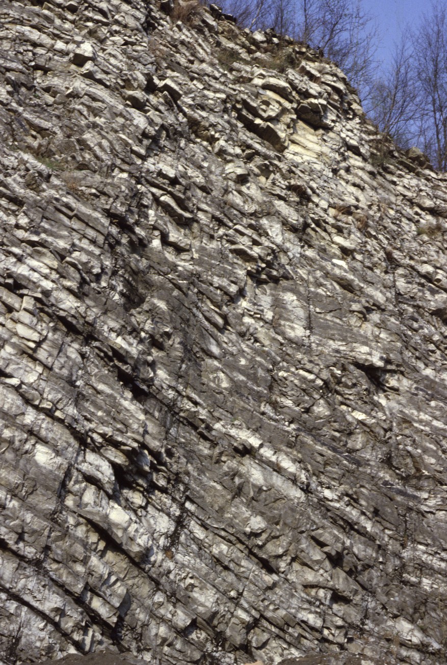
The infilling of the troughs may be over 3000 m in non-decompacted thickness, as in the Generoso Trough, in a time spanning the late Hettangian to the early Pliensbachian—i.e., about 250 m/My. For discussion on compaction and thermal history, refer to Bertotti (2001). The Moltrasio Limestone forms most of this infilling and consists of alternating grey, dark, marly limestone and marls, frequently with chert nodules, lenses, and bands (Fig. 45). Internal subdivisions are not obvious because of alpine tectonics disrupting monotonous successions and the soil-prone nature of the rocks. Tentatively, we may recognize a lower part more calcareous with abundant cherts; an intermediate part with thicker bedding, often clearly gradated with distal turbidites and more rich in clay; and an upper part in which the infilling by density current gradually decreases, as well as its clay content. Cherts are always present, but with a discontinuous and irregular distribution. Near the margin of the troughs, activated by syngenetic normal faults (Fig. 46), breccias and more coarse reworked material may be present. Decametric-thick slumpings are also observed. The Moltrasio Limestone may form 70–80% of the whole Jurassic succession. The origin of these sediments is not fully obvious. The clay may originate from the nearby emerging lands on the European continent, where the landscape was dominated by old and mature forms, rich in soils. The ongoing general transgression due to the increasing sea level (Hallam, 2001) may have provided such an amount of clay, eroded by the advancing seas on the peneplaned Variscan continent. More difficult is to search for the origin of the micrite. Bottom production should have been almost nonexistent, and calcareous phytoplankton was increasing in density and diversity (Erba, 2006), but it was not sufficient to account for such an imposing amount of micrite. The only viable source is the micrite exported in suspension from more distant shallow-water carbonate platforms, not from the near paleohighs, which are too small and partly already below the photic zone. The chert originates from the diagenesis of silica-sponge spicula and to a lesser extent of radiolarians.
Figure 45. Moltrasio Limestone.

In the middle part of the Moltrasio Limestone in the Generoso Trough, distal turbidites and m-thick slumping are very frequent. (Photo M. Gaetani).
Figure 46. Syngenetic faults between paleohigh and basin.
Sketch of the western slope of the Corni di Canzo Swell. Situation at the end of Lower Jurassic. (From Gaetani and Erba, 1990).
During the Pliensbachian, the accelerated infilling gradually decreased, and sedimentation was prevalently calcareous, with a reduced amount of clay, and also often less rich in silex. Micrite from nannoplankton became important (Cobianchi, 1992).
Because of quarries, some of them still active, the paleohigh of Arzo in the Arbostora complex is the better studied (Wiedenmayer, 1963). Very reduced sedimentations, gaps, and fissure fillings are the rule.
Moving eastward, through drowning occurred later, starting in the Sinemurian or even later, as on the Botticino Dome. The margin of the Lombardian Basin and the evolution of the Garda Escarpment have been studied in detail by Castellarin (1972) and later reconsidered by Picotti and Cobianchi (1996).
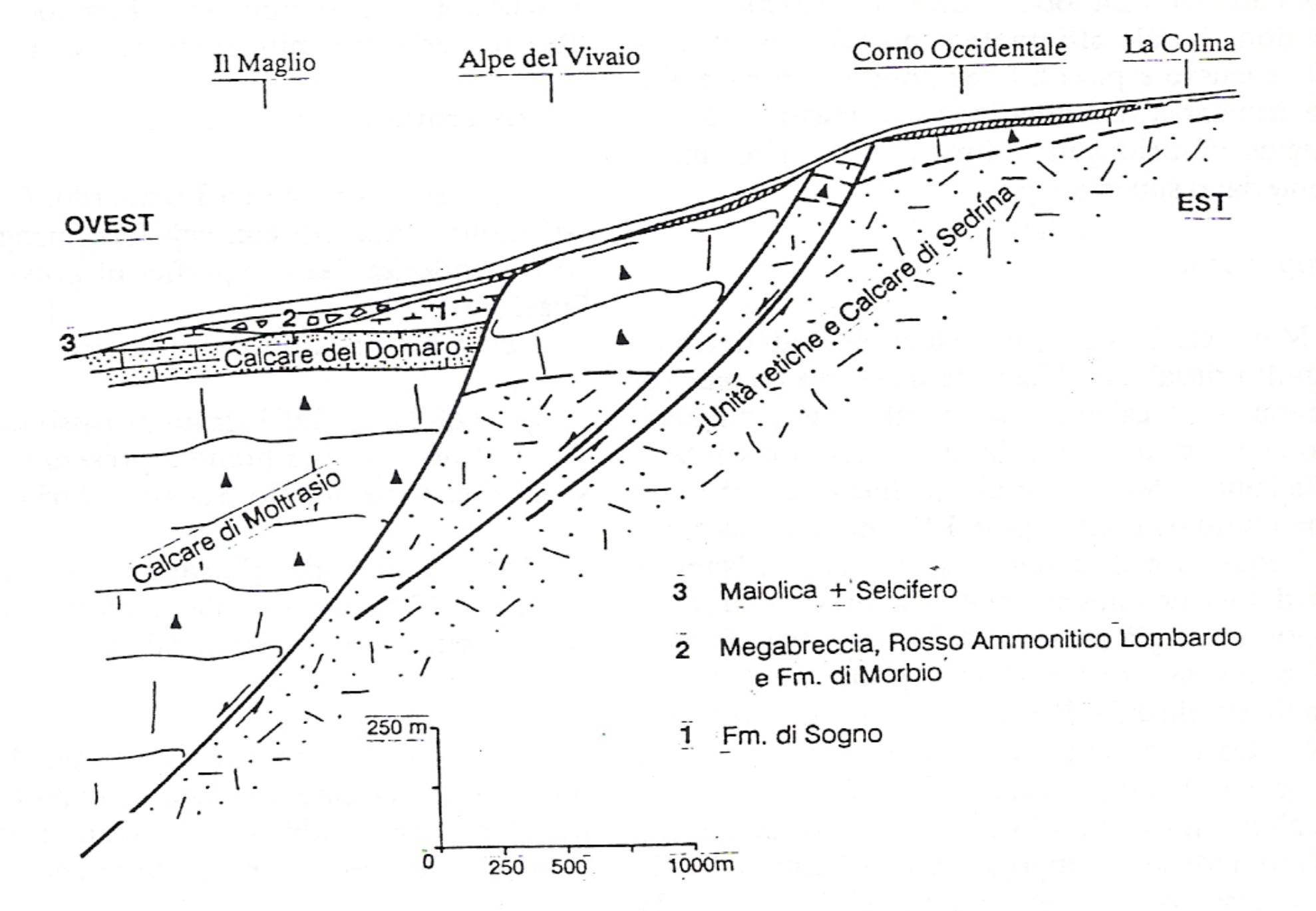
The Trento Plateau, some 60 km wide, remained under shallow-water conditions with carbonatic sedimentation during the interval Hettangian–earliest Toarcian. The Calcari Grigi di Noriglio Fm. represents this interval, and it was subdivided into three members (Bosellini and Broglio Loriga, 1971). Only toward the margin in the direction of the Lombardian Basin did an oolitic body develop (Massone Oolite). The general trend is from the peritidal platform in the lower part to oolitic shoals in the middle and lagoonal facies upwards (Masetti et al., 1998; Clari and Masetti, 2002). The total thickness hardly reaches 500 m. (Fig. 47).
Figure 47. The Calcari Grigi Formation.

The Calcari Grigi Formation represents the peritidal carbonate complex that developed during the lowermost Jurassic (Hettangian to Pliensbachian) on the Trento Plateau. It was a potential source for the micrite exported in the nearby basins. Fanes Altopiano (Photo M. Gaetani).
In the lower part, layer surfaces revealed an enormous number of dinosaur tracks (Avanzini et al., 1997; Leonardi and Mietto, 2000). The upper member (Rotzo Member) is instead very typical for the spread and diversified Lithiotis facies (Accorsi Benini and Broglio Loriga, 1977; Accorsi Benini, 1979).
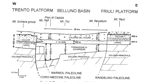
The next paleogeographic main element eastwards is the Belluno Basin, described as an ancient analogue of the “Tongue of the Ocean” (Bosellini et al., 1981). Its drowning occurred in the early Sinemurian. It acted during this phase mostly as a starved basin (Soverzene Fm., 400–1200 m thick; Sarti et al., 1992), fed by the micrite and locally coarser clasts originating from the nearby carbonate platforms. The Belluno Basin joined the Slovenian Basin (Cousin, 1973; Buser, 1987), contouring the Friuli Platform, which is the last main paleogeographic element. During the Early Jurassic, the Belluno Basin widened in successive steps at its western margin, extending for an additional 20 km at the expense of the Trento Plateau (Clari and Masetti, 2002; Carulli et al., 2002) (Fig. 48).
Figure 48. Platform vs basin in Carnia.
The relationships between the Friuli Platform and the Belluno Basin in western Carnia. (From Carulli et al., 2002).
On the Friuli Platform, shallow-water carbonate sedimentation continued through all of this time. The shelf edge is activated by normal faults and partly rimmed by oolitic shoals. The uppermost Triassic and the Lower Jurassic are represented by mostly undolomitized facies, referred to as the Dachstein Limestone and the Calcari Grigi (Carulli et al., 2002). In the core of the platform, successions are very reduced in thickness and are still partly dolomitized in the Lower Jurassic beds: the rimmed platform includes a lagoon, in which isolated coal seams and pelletal wackestone are present (Venturini, 2002). Boreholes revealed that the Friuli Platform is dissected by a deeper area since the Pliensbachian, the Friuli Basin (Cati et al., 1987).
The Toarcian-Aalenian last step of rifting
The continuous crustal extension acting for at least 35 My had already sufficiently widened the seaway which, during the Middle Jurassic, will provide the floor of the Ligurian-Piedmont Ocean. This is also evidenced by the presence of the Toarcian Oceanic Anoxic Event (T-OAE) in the deeper part of the basins (Erba and Casellato, 2010).
During this final step of the rifting, the Lombardian Basin continued to deepen. Accomodation being only partially compensated by sedimentation, the basin became progressively starved. The Trento Plateau became the site for oolitic shoals and more open carbonate facies, even if not too deep. The Belluno Basin also was affected by the Anoxic Event, but its sedimentation was characterised also by resedimentation of significant volumes of shallow-water carbonates originating from the Friuli Platform, which continued to remain in shallow-water conditions.
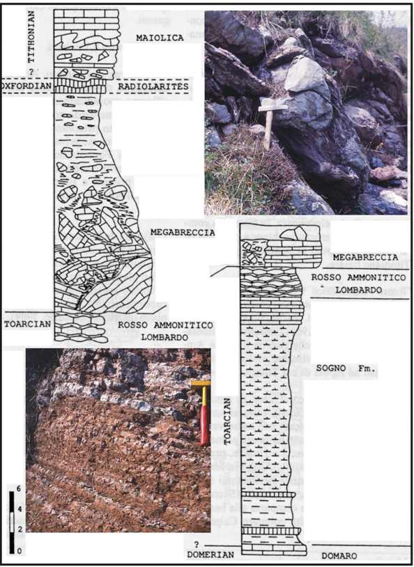
In the Lombardian Basin, it is possible to date the onsetting of this third step, within the Tenuicostatum Zone of the lowermost Toarcian. The mudstone/wackestone with some minor quartz and muscovite clasts of the top of the Domaro Limestone are abruptly substituted by grey and brown marls eventually ending in the black shales of the T-OAE (Jenkins, 2003). The level, known also as the “Fish Level”, is usually less than 1 m thick but may reach more than 10 m in the most expanded sections. The T-AOE is preserved only in the deepest depressions. The best section is the Colle di Sogno (Tintori, 1977; Gaetani and Poliani, 1978). The expansion of an enormous amount of basalts in the Karoo-Ferrar Province (Jenkyns, 2003) would have introduced in the oceanic-atmospheric system a huge amount of CO2. The destabilization of the previous equilibrium also would have caused, among other things, an enormous increase of the primary productivity in organic matter (Erba, 2004). With the decreasing of the volcanogenic CO2, oceanic conditions returned to more oxic and sedimentation was characterized by two types of facies. One is represented by condensed red mudstone nodules embedded in a marly matrix (Rosso Ammonitico Lombardo—a few tens of m thick), locally rich in ammonite moulds. The second is a cyclic coupling of grey marls and marly limestone, presumably astronomically controlled in their deposition (Sogno Formation, up to 145 m thick). Near the swells and paleohighs, sedimentation on the slopes is evidenced by fluidal textures in the Rosso Ammonitico and rarer breccia bodies. A major syntectonic event is recorded in the Generoso Trough, where a huge landslide occurred during the Aalenian, when rock slabs including rocks from the upper Pliensbachian until the Toarcian became embedded as boulders up to several m wide in the slumped material (Gaetani and Erba, 1990) (Fig. 49).
Figure 49. The Aalenian last major slumping.
At the foot of the slope of the Corni di Canzo Swell, a huge accumulation of slumped material cut deep into the Toarcian Rosso Ammonitico Lombardo. The slope persisted through the whole Jurassic and resedimented cobbles are included in the Rosso ad Aptici and the Maiolica. (From Gaetani & Erba, 1990) (Photos M. Gaetani).
Carbonate deposition gradually ended with the lowest Bajocian, and residual red clays carpeted the bottom of the Lombardian Basin.
On the Trento Plateau, as a consequence of the drowning, environments moved from the restricted lagoons of the Rotzo Member of Calcari Grigi to the open shoals of the Oolite di S.Vigilio and its marginal facies. toward the Lombardian Basin, it may reach 200 m in thickness, dying out toward the core of the plateau. It consists of poorly stratified oolitic and encrinitic grainstone with festooned cross-lamination. The emerging surface is characterized by ferruginous crust and hard ground with pelagic stromatolites (Massari, 1979).
In the Belluno Basin, there are partly reproduced facies already met in the Lombardian Basin. The Igne Formation, with cyclic grey marls and marly mudstone recalls the Sogno Fm., containing the early Toarcian Anoxic Event, recorded by discontinuous levels of black shales. Layers with marly Rosso Ammonitico are also present.
On the Friuli Platform, the rim was made of oolitic shoals, while toward the centre of the platform, peritidal dolomitized layers occasionally occurred. But this interval seems to be poorly documented or already included in the base of the Cellina Limestone (Venturini, 2002). The deeper area internal to the platform detected through boreholes persisted in being active (Fig. 50).
Figure 50. Friuli Platform.

The Friuli Platform appears to be dissected by an internal deeper area since the Pliensbachian. The other parts of the platform remained in shallow-water condition through the whole Mesozoic. (From Cati et al., 1987).