Uplift and denudation rates as driving factors of present day morphology
Beside recent tectonic activity, geologically controlled relief forms (as for instance described in Bartolini, Peccerillo, 2002) result from regional uplift, a prerequisite of lithostructural landforms (see Fig. 9).
In order to outline this prompter of morphogenesis as to the Italian region, a brief outlook on present day rock and surface uplift rates both in the Alps and in the Apennines follows.
Alps
In the Central Alps, on either side of the chain, Wittmann et al. (2007) pointed out that a fair correlation relies on geodetic measurements of surface uplift and denudation rates as obtained by 10Be cosmogenic nuclide-derived denudation rates, computed on a millennial scale.
As shown in Figure 5, the present uplift and denudation rates cope at large with the Alps relief. This is in line with the circumstance that, according to the same authors, the uplift pattern resembles that of apatite fission track age distribution, which would suggest long-term stability of the uplift process at the Ma timescale.
Wittmann et al. (2007) compared the denudation rates affecting the Alps, estimated with various methods at different timescales (Fig.6). Long term denudation rates estimated from apatite fission tracks compare fairly well with lake infill dates, although the latter refer to a much more recent time span. Cosmogenic radionuclides data show, instead, a large spread of values probably connected with the pitfalls of the method. Present day denudation rates based on river load data are surprisingly low. This may be due to the short time interval they represent and to the ensuing influence of the anthropic impact; but also, as pointed out by Bartolini and Fontanelli (2009), to the limits inherent to the method.
Figure 5. Recent vertical movements in the Central Alps.
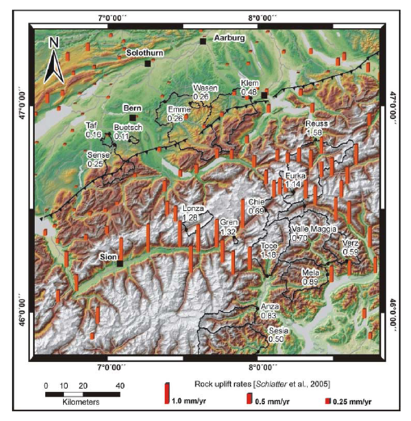
Bar heights give the rate of rock uplift relative to the benchmark at Aarburg. Denudation rates, based on catchment-wide cosmogenic nuclide analysis, are given in mm/a. From Wittmann et al., 2007, JGR, 112, F04010, doi:10.1029/2006JF000729.
Figure 6. Denudation rates estimates from different methods plotted against their corresponding timescale.
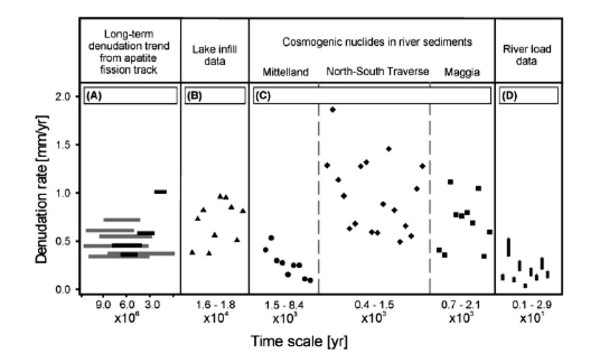
From Wittmann et al., 2007, JGR, 112, F04010, doi:10.1029/2006JF000729.
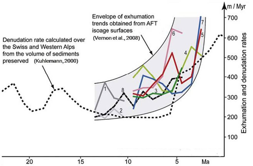
As shown by Vernon et al. (2008), Fig. 7, the envelope of exhumation trend and the denudation curve show an increase centered before 5 Ma.
Figure 7. Comparison between the estimates of average denudation rate (recorded in sediment volume) and exhumation rate (using AFT isoage surfaces) over the Western Alps.
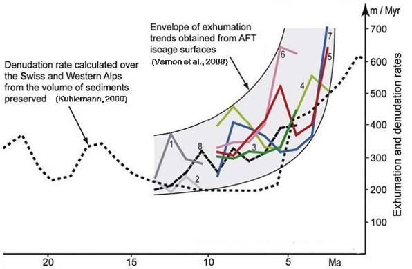
The average Western Alps denudation rate calculated by Kuhlemann (2000) is the ratio between the peri-Alpine sedimentation rates and the provenance area. Both the envelope of exhumation trend and the denudation curve show an increase centered before 5 Ma. From Vernon et al., 2008.
As to the factors influencing the denudation rates, Malusà and Vezzoli (2006) pointed out that in the Western Alps, rather than lithology and climate, the differential upward motion of crustal blocks is the main agent. The study area, the authors state, shows in fact a close spatial relationship between the pattern of short term rates and that inferred from fission track dating.
Apennines
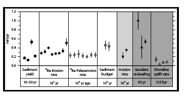
Several methods aimed at evaluating related variables concerning the erosion rates affecting the Northern and Central Apennines at timescales ranging from the present day to one Myr have been matched by Cyr and Granger (2008), as reported in Figure 8.
Excluding the three columns shaded in grey, which refer to data affected by various limitations, most rates range from 0.2 to 0.5 mm/y. Similar results have been worked out by numerous other authors based both on sediment budgets (Bartolini et al., 1986; Bartolini, 1999; Bartolini, Fontanelli, 2009) and on thermochronologic methods. (Balestrieri et al., 2003; Ventura et al., 2001; Zattin et al., 2002).
Figure 8. Denudation, fluvial incision and uplift.
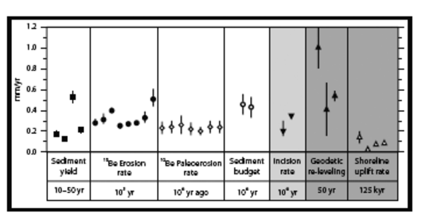
Rates of denudation (white area), fluvial incision (medium grey area) and uplift (dark grey area) in the Northern and Central Apennines inferred from seven different techniques over decadal to million-year time scales. From Cyr and Granger (2008), Geology 36, 103 – 106.
Northern Apennines: is local relief a proxy for uplift history?
Apennine backbone vs Apuan Alps
The present, subdued relief of Northern Apennine depends on:
the Basin and Range type structure of the inner sector of the Apenninic Chain
the prevailing flysch lithology
the current – mild - morphoclimatic regime
These factors hamper a high relief to set out, despite the high rock uplift rates that affect the Chain, as exhumation rates obtained from low temperature thermochronological methods have recently pointed out.
Exhumation rates were often confidently translated into rock uplift rates implying that surface uplift was mainly negligible. As a matter of fact, the term "uplift" has been often referred in the past to either surface and rock uplift. England and Molnar (1990) pointed to the importance of a clear distinction. They defined "surface uplift" as the displacement of Earth’s surface with respect to the geoid; "exhumation" as the displacement of rocks with respect to the surface. The sum of the rates of these two processes gives the rate of "rock uplift", that is the displacement of rocks with respect to the geoid:

Since in mountain ranges exhumation occurs at a fast pace, the distinction between uplift of rocks (i.e. crustal uplift) and surface uplift cannot be overlooked. The reason it used to be lies in a naturally conservative attitude which hampered most geologists to take into account, while tracing paleogeographic settings, that through geologic times relevant rock masses are being wiped off.
This attitude may typically be detected whenever the feeding to a Quaternary sedimentary basin is discussed: the surface geology to which the source rocks are referred is commonly the present day one, despite the fact that in most mountain areas, not less than 1 km of rocks, on average, has been wiped off since early Quaternary.
Another case is that of the Messinian deposits of the Tyrrhenian area. Although they were feeded from the West, as proven by clast lithologies which never outcropped in the mainland (Pandeli et al., 2009), apparently no one ever ventured to think that the Tuscan area could have been, at the time, part of the inner shelf of the Apennine foredeep. The line of reasoning had apparently be that, since Messinian outcrops are lacking all over the Chain, the latter emerged at that time. It may well be, instead, that Messinian deposits were blanketing the Ligurids as late Epiligurids.
Recent investigations in the Apuane Alps area (Balestrieri et al., 2003) allowed a most interesting time scan of exhumation rates to be worked out. Between about 11 Ma and about 6 Ma, the cooling rate was between 10° and 16°C/Myr, which correspond, assuming a geothermal gradient of 25°C/km, to exhumation rates of 0.4-0.6 mm/y. Between 6 Ma and 4 Ma, cooling rates increased to between 38° and 55°C/Myr, equivalent to an exhumation rate of 1.3-1.8 mm/y, presuming a geothermal gradient of 30°C/km (such an increase of the geothermal gradient from the Messinian onwards is consistent with the onset of the Tuscan geothermal anomaly as well as with the higher exhumation rates). The last part of the thermal path (4 MA to present) is not well constrained due to lack of AHe data, but the average exhumation rate is between 0.6 and 0.9 mm/y (assuming a geothermal gradient of 30°C/km). The slowing down of the exhumation rate since Middle Pliocene is certainly related to the surface exposure of the highly resistant rocks belonging to the Tuscan Metamorphic Unit and to the Paleozoic Basement which began to occur at that time, as proven by the lithologic composition of the continental basin sediments fed to the east by the Apuane Alps erosion.
In the Apuan Alps, the last major incision of streams occurred during the Middle Pleistocene while no significant uplift took place during the Late Pleistocene (Piccini et al., 2003).
As geomorphic and thermochronologic evidence points out, the higher rock and surface uplift rates occur at present over the drainage divide of the Northern Apennine. A wealth of apatite fission-track data has been worked out recently in the central and eastern sector of the Northern Apennine (e.g. Zattin et al., 2002). Mt. Falterona, consisting of Miocene foredeep deposits (Marnoso Arenacea Fm.), is located along the present drainage divide on the north-eastern edge of the Mugello Basin. According to Zattin et al. (2002), the pre-exhumation configuration features a 4 to 5 km thick cover (depending whether a geothermal gradient of 20°C/km or 25°C/km is assumed) of overlying Ligurian and Epiligurian Units, which was completely eroded in the last 5 Myr at a mean rate of 0.8 to 1 mm/y. Since geological data suggest that little or no relief was present in the area between 5.0 and 2.0 Ma BP, rock uplift rates should have been quite similar during that period to the computed exhumation rates of approximately 0.8 mm/y. Surface uplift was therefore negligible. As a matter of fact, a residual veneer of Ligurids at places presently buried under the fluvial deposits both in Mugello and in the nearby Casentino basin indicate that the 5 km thick Ligurids cover had not been completely wiped out when the basin became the site of flood plain sedimentation, that is around 2.0 Ma. The high exhumation rates occurring between 5.0 and 2.0 Ma despite the prevailing low relief was made possible by the high erodibility of most lithotypes which make up the Liguride Complex.
Conclusive remarks on local relief as a proxy of present uplift rates
The slowing down of rock uplift rates in the Apuan area, compared with the present chain divide, fits the well established eastward-younging foredeep and synrift deposits and the migration of the orogenic processes and related features as well.
Despite the much lower rock uplift rates, the present average altitude of the Apuan peaks (1500 to 1900 m) is very close to that of the Apennine divide. As a matter of fact, the higher rock uplift is here largely compensated by the higher erodibility of the turbiditic sandstones which make up the Chain backbone. Because of the prevailing low erodibility, the local relief of the Apuan Alps is to such an extent greater than that of the typical Apennine chain, to deserve their odd name whereby a crumble of “Alps” lies well within the Apennines.