Scientific research of synergistic analysis and application in Google Earth
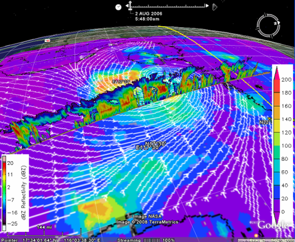
Figure 7 integrates data for the typhoon Prapiroon on August 2nd, 2006 from the TRMM satellite and from the CloudSat satellite. On this date, the typhoon was located over the South China sea and the CloudSat parameter shown is the dBZ reflectivity. The heights of the highest clouds are ~15 kms and substantial convective activity can be seen within the vertical structure of the typhoon. The 3B42 daily TRMM data is showing the rainfall rate and QuikSCAT data showing the wind in the area of typhoon. The integration clearly shows the relationship and interaction of typhoon, rainfall, cloud, and wind. Scientists use such results to forecast weather and disasters, analyze climate change, report air quality, and carry out other atmospheric-related scientific research. It can also help general users to comprehend relationships among rainfall, cloud, and wind.
A real-time weather forecast can be implemented in Google Earth and shown on the Earth’s surface. Professionals can utilize the existing landmarks, road signs, and political boundaries in Google Earth to accurately judge the location of thunderstorms or sandstorms to refine forecasts or advance research. With the wide and increasing utilization of high resolution Google Earth images in scientific communities and public discourse, such scientific research and applications become more interesting and practical. As concern about global climate and environment change becomes more serious, scientists, decision-makers, and policy-makers must be increasingly concerned about the regional environment and the occurrence of sudden natural disasters. This methodology allows scientists to easily integrate socio-economic data and information with geospatial data to enable improved decision-making during crises, exemplified by hurricane forecast and rescue operations. Based on Google Earth, all past and near-real-time data and information about the atmosphere, sea and rainfall from satellites and ground stations can be integrated for decision-making agencies and individuals. Any available or possible information related to rescue tools, search plans, agents, and volunteers can be dynamically and interactively put together via geospatial position in Google Earth for timely rescue and help.
