The Bega Batholith
The 420-400 Ma old Bega Batholith is the largest I-type batholith in the LFB, comprising 8940 km2 if the Moruya suite is included (Chappell 1996). It extends some 300 km from east of Canberra in the north to Bass Strait in the south and is composed of >130 plutons which have been divided into 50 suites, which can be grouped into 7 supersuites (Beams 1980). The supersuite extend as narrow linear arrangements of chemically related plutons, aligned N-S, parallel to the batholith trend (Figure 1) and that of the major structural trends of the low-grade country-rocks of Ordovician metasediment.
The two central supersuites of the batholith are Candelo and Kameruka, covering an area of 1200 km2 and 1350 km2, respectively. Candelo is dominated by tonalite and granodiorite, whereas Kameruka is dominated by granodiorite and monzogranite. Candelo Suite granites are distinguished by the presence of conspicuous hornblende crystals, interstitial quartz, and a paucity of K-feldspar megacrysts. The Kameruka granodiorite is a spectacular, coarse-grained rock with distinctive pink K-feldspar (4-10 cm) megacrysts, white rectangular plagioclase (1-4 cm) and rounded grey quartz grains (~ 1 cm). We focus on the Kameruka pluton and associated plutons of the suite.
Kameruka Pluton
The Devonian Kameruka Granodiorite (Figure 1) is a relatively large (570 km) and well-studied I-type pluton in the central part of the Bega Batholith, which is part of the Kameruka Suite (Beams 1980; Chappell et al. 1991; Chappell 1996). U/Pb dating on zircon from the pluton has revealed an age of around 420-425 Ma (Healy pers. comm. 2004). The pluton consists mainly of coarse-grained biotite granodiorite and is characterised by the presence of alkali-feldspar megacrysts up to 10 cm in length (Figure 5a). The Kameruka pluton extends from Cobargo in the north to Towamba in the south, a distance of ~100 km, but only reaches a maximum width of 12 km in the Bega Valley. The elongate, orogen parallel nature of the pluton suggests a strong structural control on emplacement – we will be addressing the nature of pluton emplacement over the two days.
Figure 5. Kameruka Pluton
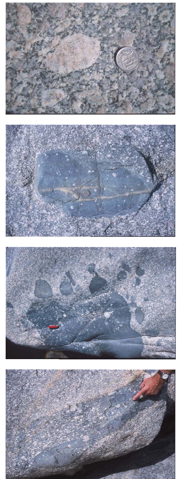
5a) White ovoid pseudomorphs after K-feldspar in Kameruka pluton. 5b) Double enclave with xenocryst poor core and xenocryst rich rim. 5c) Complex heterogeneous enclave showing at least four mixing stages, including an outer feldspar-rich rind contiaining rounded enclaves. It is gradational with the host granite. 5d) “Layered” enclaves consisting of xenocryst- rich and -poor sheets. It resembles some enclave layers at Illawambra
Excellent exposures within the Bega River provide a complete east-west traverse through the pluton. The western contact of the Kameruka Granodiorite dips moderately (50-700) to the east; sub-concordant with deformed (syn-migmatitic), migmatitic Ordovician metasediments. The eastern contact is much steeper, sharp and characterised by low-grade (relative to migmatites that characterise the western contact) hornfels.
The thickness of the pluton can be crudely estimated from the internal structures. They consist mainly of a locally, but well-developed feldspar foliation, swarms of mafic enclaves, sparse large tabular bodies of diorite, and planar boundaries between megacryst-rich and –poor phases of the granite. These features occur sporadically throughout the studied section and consistently dip moderately to steeply to the east. They tend to be steeper in the west (50-70 degrees) and shallower to the east (50-20). The internal features imply that the pluton dips eastward and has a thickness of 7-10 km. Reconstructions of the internal geometry of the pluton combined with detailed gravity has shown that the pluton is wedge-shaped, exhibiting a steep root on the eastern side, shallowing progressively to the west where the base of the pluton is exposed in the Wog Wog River (see Figure 2, Figure 4 and Figure 6 at end of the guide)
Figure 6. Characteristic Features
Details of some of the characteristic features we will be observing on this trip. The top cross-section is applicable to stops on the first day in the Towamba River and Lower Wog Wog River. The lower cross section shows features observed on the second day in the upper Wog Wog River.
Enclave swarms (Figure 3c) and individual enclaves display a range of small-scale features suggesting that they were deposited on a loosely packed mixture of crystals and interstitial melt (i.e. the floor of a magma chamber). Larger, chilled mafic enclaves typically have slab-like or pillow-like shapes and are strongly moulded around underlying feldspar megacrysts, which are commonly very tightly packed beneath these enclaves. In many swarms, individual enclaves are commonly moulded around each other, leaving only a very small residual matrix of megacryst-rich granodiorite (we will examine some of these enclave-rich “deposits”). All of these features suggest that compaction occurred immediately after deposition of the enclaves, while most of them were still soft (partly liquid). Where way-up criteria is available, swarms consistently indicate top to the east.
Significance of Variable Enclave Compositions
Enclaves display abundant evidence of several stages of mixing; an important part of the geochemical and tectonic story. Double enclaves are common and most enclaves contain some megacrysts identical in size and shape to crystals in the Kameruka granodiorite (Figure 5). Alkali-feldspar megacrysts in the enclaves are commonly rounded in shape and typically have very broad rims consisting of inter-grown small, normally zoned, subhedral to euhedral plagioclase crystals with interstitial quartz. Adjacent enclaves have widely different proportions and sizes of megacrysts, suggesting that mixing occurred both locally, but more importantly, remotely, prior to deposition.
The proportions and character of the feldspar megacrysts vary widely on the scale of the entire intrusion and, more locally, within large, well-exposed stream outcrops. Near the western margin of the intrusion, alkali-feldspar megacrysts are generally homogeneous, evenly distributed and lack rims of sodic plagioclase. Further to the east, stratigraphically above some major swarms of mafic enclaves, alkali-feldspar megacrysts are generally more scarce and unevenly distributed: most show plagioclase rims of varying thickness and are extremely similar to mantled K-feldspar found within the enclaves. These relations strongly suggest that the common mantles on alkali-feldspar at higher structural levels in the Kameruka were caused by the input of higher temperature, mafic magma as preserved in enclave swarms. Thus, it is likely that mafic input only affected local volumes of the magma chamber, and that batches of magma with different crystallization histories did not mix completely.
Summary
Because depositional features in the Kameruka Granodiorite occur throughout the studied section and provide a consistent sense of top to the east, we interpret the western margin as the base of the intrusion and the eastern margin as the roof. This interpretation is consistent with the contrast in metamorphic grade of the country-rocks, from migmatitic in the west to hornfelsic in the east. The evidence for way-up structures mentioned above suggests that the pluton formed by floor aggregation and thus provides a stratigraphic record of events (e.g. crystallization, replenishment of mafic and felsic magmas, and mixing) in a granodioritic magma chamber.
Base of the Kameruka Pluton
Pluton Geometry and Regional Cross-section
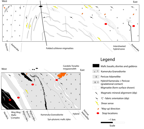
The Kameruka Pluton is a N-S trending, wedge-shaped pluton (cross-section) aligned parallel to the regional structural trend of the eastern Lachlan Fold Belt and of the Bega Batholith (Figure 1). The Pericoe Adamellite is the other pluton of the Kameruka Suite; it is a small (60 km2) body mapped as a separate pluton by Beams (1980), lying to the west of Towamba (Figure 2). A narrow rim of Kameruka granite was noted by Beams (1980) in its western side. We will now focus on the Kameruka pluton in the vicinity of Towamba, where mapping demonstrates that Pericoe is the upper part of a regional synform or basin-shaped depression in the Kameruka pluton.
According to the internal structures of the Kameruka pluton in the Bega region, the base is to the west and top is to the east. The eastern margin of the pluton is sub-concordant to steep, east-dipping structures, overprinted by a narrow hornfelsed aureole, whereas the western margin is dominated by moderately E-dipping migmatites. Similar relations are observed in the Towamba area, but further west in the Wog Wog River (Figure 2), the relatively simple geometry of the Kameruka pluton changes. There, internal features and the enveloping structure of the underlying migmatites indicate that the pluton has a geometry similar to a gently S-plunging asymmetric, west-verging antiform, however, thee is very little evidence of deformation (post full-crystallisation compressive deformation) within the pluton. However, the presence of leucosomes and granite in the axial plane of scattered, open folds is evidence to suggest that the pluton has undergone a minor degree of late-syn-emplacement deformation. We can discuss the significance of this feature over the two days.
In the upper Wog Wog River, migmatitic layering and foliation are concordant to E-dipping gabbroic sheets of the WWGC (adjacent to the campsite), however, both of these structures are discordant to N-trending, tight, upright fold structures in the underlying lower grade metasedimentary rocks. These structures are correlatable with the regional D1 and D2 structures outside the Bega Batholith, which have developed in low-grade, greenschist facies metasediments. Therefore, the east-dipping migmatitic foliation is S3.
The overall geometry of the pluton is best described from west to east along the Wog Wog River (X-section, Figure 2 and Figure 6). Southeastward from the Burragate Fault, low-grade, folded metasedimentary units underlie the E-dipping, E-younging, inter-sheeted Wog Wog Gabbro Complex (WWGC – Day 2 stop 1). Overlying the WWGC and separating it from the Kameruka Granodiorite is a km-wide zone of stromatic metatexites and schlieren diatexites, structurally concordant with the WWGC. The migmatites lie stratigraphically below a concordant (east-dipping) km-thick sheet of Kameruka Granodiorite, a succession that is repeated in the lower Wog Wog River. The granodiorite throughout this section contains a high degree of inter-sheeting between different phases together with a large number of mafic bodies (we will walk through this section on Day 2). Farther to the east (up-section) a 600m-wide complex zone (contact) between the Kameruka and overlying Pericoe pluton is exposed. The contact zone is marked by the presence of an 'elephants graveyard' including the large block of Candelo Tonalite
(Day 2 final stop).
Several km downstream, the eastern margin of the Pericoe pluton is steeply west dipping and is gradational with a narrow sheet of Kameruka granite which itself grades rapidly into a steep, west-dipping zone of schlieren migmatites. The migmatites here have a well-developed foliation and shear sense indicators that show west-side-down (normal) movement.
Farther east, the migmatites fold over an open, gently south plunging antiform where they dip to the east again, below the basal contact of the Kameruka Pluton in the lower Wog Wog River (Figure 2) (Day 1 Stop 2).
Way-up structures are present in the WWGC, in the Kameruka pluton, in the contact zone and in the Pericoe pluton. All suggest that the rocks are "right way up" and confirm that the Pericoe pluton is a basin-shaped structure overlying the Kameruka pluton (Figure 2).