Lawver et al (1999) give a plate-reconstruction perspective to tight-fits
The innovative approach used by Lawver et al in constraining the fit of the southern continents was their use of gravity data to constrain the continent-ocean boundary. The reconstruction (Figure 5) is based on marine magnetic anomalies, other seafloor age data, seafloor bathymetric features and tectonic fabrics indicating past motion directions determined from satellite altimetry. The authors utilised an absolute palaeomagnetic reference frame to derive motions back to 130 Ma, and a combined hotspot (Coffin and Eldholm, 1994) and palaeomagnetic reference frame (Van der Voo, 1993) to calculate a new framework back to 200 Ma. This study also utilised a purpose-built software package, Plates, to visualise the fit and subsequent rotation history of Gondwana. The authors proposed mantle plumes as a trigger for the break-up of Gondwana and, more specifically, the Parana – Etendeka plume for triggering the initial split of South America from Africa at 132 Ma.
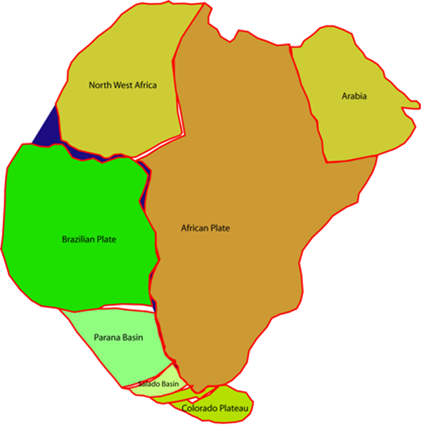
Figure 5. Lawver, et al., 1999.
Detailed image of the Lawver et al. (1999) tight fit for South America and Africa.
The South America – Africa fit proposed by Lawver, et al, is illustrated in Figure 5. As with the fit of N&M described previously, Lawver, et al, utilised movement/rifting to account for some of the misfit: in the Parana Basin, within the Colorado Basin, around the Falkland Islands microplate, and in the West African Rift. Lawver, et al., mentioned three overlaps: two deltaic (the Niger and Amazon Deltas) deposits are accounted for as they are post-break-up features. The third overlap is in the region of the Abrolhos and Royal Charlotte Banks, which are a result of magmatic activity post-dating break-up by 80 – 100 million years. These overlaps appear only to be of the shallower regions of the continental margins (green outlines in Figure 9). Some apparent overlap of the deeper margin areas around the Colorado Basin/southern Africa region and the Falkland Islands/southern Africa region is not addressed by the authors and may be a result of discrepancies between the gravity data and the present continental boundary. Lawver et al. did not publish their Euler rotation data.