Nürnberg and Müller (1991) utilise improved technology
In their reconstruction of the tectonic history of the South Atlantic since the Jurassic, Nürnberg and Müller (1991) aimed to provide a complete history of the separation of Africa from America from a fit position to the present day.
Nürnberg and Müller utilised a recent marine magnetic anomaly compilation and the vertical deflection data obtained from the GeoSat database to substantiate the previously existing marine magnetic anomaly database with the tectonic flow directions and lineations. From this compilation, they established that the first ocean crust formed during with marine anomaly M4 (126.5 Ma) and abuts the continent-ocean boundary. Consequently, the authors defined their continental plate boundaries as the continent-ocean boundaries modified from that of Emery and Uchupi (1984) by Gahagan et al. (1988) using GeoSat data.
As well as an improved marine data, Nürnberg and Müller incorporated intra-continental extension and strike-slip movement. In South America, they focussed on the Parana-Chacos, Colorado, and Salado basins, and proposed addition crustal extension in NE Brazil. In Africa, they invoked movement along the Benue Trough/Niger Rift system. Movement in these systems was assumed to have been prior to or during break-up.
Figure 4. Nurnberg and Muller, 1991.
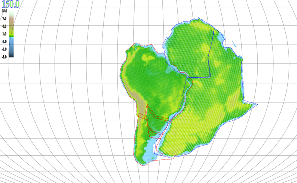
The rigid-plate reconstruction of Nürnberg and Müller (1991) as presented by Pplates. Africa has been rotated according to the Global Isochron Chart (Royer et al. 1992)
Their model supposes that the initial rifting in the southern Atlantic region at 150 Ma progressed northward to ~38oS when rifting in the Colorado basin began. Subsequent northward propagation of the rift caused deformation in the Salado basin and in the Parana-Chacos basin from 130 to 126.5 Ma. The rift continued northward into the Niger Rift area, inducing rifting and strike-slip motion between 126.5 and 118.7 Ma. The Niger Rift failed by 84 Ma, following which the Atlantic opened by divergence between the Guinea and Demarara Plateaus (with additional crustal extension in NE Brazil) thus separating the South American and African plates.
This model was accommodated by breaking southern South America into three sub-plates (the Colorado, Salado, and Parana) and breaking NW Africa from Africa along the Benue Trough/Niger Rift system. Their initial fit at 150 Ma was based on a reconstruction of the equatorial Atlantic, matching the Guinea and Demarara Plateaus and fracture zones from GeoSat data. They then applied a rotation of (southern) Africa relative to NW Africa to close the Benue Trough and Niger Rift, thus assuming the Trough to represent around 50 km of rifting with some strike-slip movement as it opened. The overlaps in the continental-ocean boundaries of Africa and South America were then explained by invoking subsequent extension and shear in South America. Overlap of NE Brazil, they hypothesized, could be compensated for by invoking extensions in the Reconcavo and Tucano basins during the earliest phase of rifting there. Overlaps of continent-ocean boundaries further south were countered by reversing ~65 km of rifting and 20 km of strike-slip motion in the region of the Parana-Chacos Basin. The southernmost overlap is reversed by the extensions of the Salado and Colorado basins, representing ~20 km of rifting and ~40 km of strike-slip motion, and ~40 km rifting and 20 km of slip, respectively, since the middle Jurassic.
Nürnberg and Müller (1991) provided a comprehensive rotation history resulting in a tight fit of Africa and South America. Each sub-plate to be moved rigidly was assigned the Euler poles shown in Table 2. Figure 4 shows their rigid reconstruction as rendered by Pplates. The boundaries depicted in the figure were drawn to emulate the overlap given by the authors original paper, but they were also extended in order to close those boundaries around the rigid regions. Pplates applied the rotation data to the enclosed regions and the resulting overlap (and some separation in NW Africa) of the boundaries can be seen in the figure.
Even though tectonic reconstructions have become more complex as larger, more varied datasets were incorporated, the use of rigid sub-plates does not accurately model crustal deformation.
Table 2. Euler rotations for final fit of South America and Africa (including intra-plate motions) from Nürnberg and Müller (1991)
| Mobile plate | Age (Ma) | Lat | Long | Angle | Relative to |
|---|---|---|---|---|---|
| S. America | 131.5 | 50 | -32.5 | 55.08 | Africa |
| Parana | 131.5 | -15.2 | -73.2 | 1.48 | S. America |
| Salado | 150 | -32.2 | -64.5 | 1.18 | Parana |
| Colorado | 150 | -18 | -73.2 | 1.05 | Parana |
| NW Africa | 118.7 | 16.5 | 6.7 | -1.15 | Africa |