Geological setting
The North China Basin is the largest one of the Mesozoic and Cenozoic basins in the North China Block, a block unique to the Earth’s other stable cratons in that it has remained active since the Mesozoic (~220 Ma) (Gao et al., 2002).
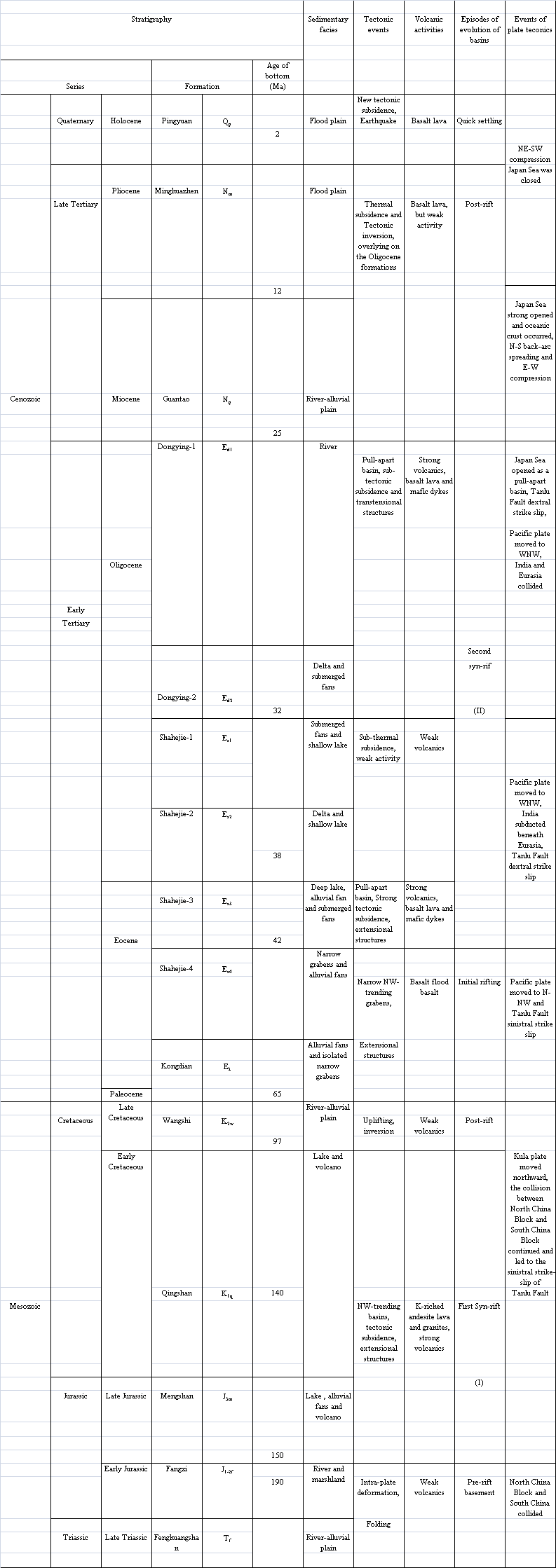
The Cenozoic North China Basin was developed on the site of a Mesozoic basin (Hou et al., 2001, 2002). The outline of the Cenozoic basin has a rhomboidal central area with slender arms that extend to both the northeast and southwest (Figure 1). The well-known Tanlu strike-slip fault zone runs in a roughly north-northeast direction through the eastern edge of the basin (Xu, 1993; Xu et al., 1993; Ross et al., 1996). The basin consists of a series of uplifts and depressions containing numerous secondary uplifts and depressions. It is comprised of six major depressions, the Jizhong, Huanghua, Liaohe, Bozhong, Jiyang and Linqing depressions (Ye et al., 1985; Liu, 1987; Lu et al., 1997; Allen et al., 1997). The offshore portion of the basin includes the Bozhong depression, the southern part of Liaohe depression, and some parts of the Huanghua and Jiyang depressions (Gong et al., 1987; Hou et al., 2003). Tertiary strata rest unconformably on a variety of older pre-rift strata and are covered conformably or unconformably by Quaternary sediments. This succession is typically 4-7 km thick within the main depression, with a maximum thickness more than 10 km in the depocenter of the Bozhong depression (Central Bohai Sea) (Ye et al., 1985; Liu, 1987; Hu et al., 2001). Lithologies are dominated by sandstone, mudstone and interbedded volcanic sedimentary rocks. The Cenozoic succession has been divided into six formations: the Kongdian, Shahejie, Dongying, Guantao, Minghuazhen, and Pingyuan Formations, which are further sub-divided into several members (Table 1). The basin experienced two phases of rifting in Cenozoic time (Ye et al., 1985; Allen et al., 1997; Hou et al., 2000, 2001).
Figure 1. Tectonic divisions of the North China Basin
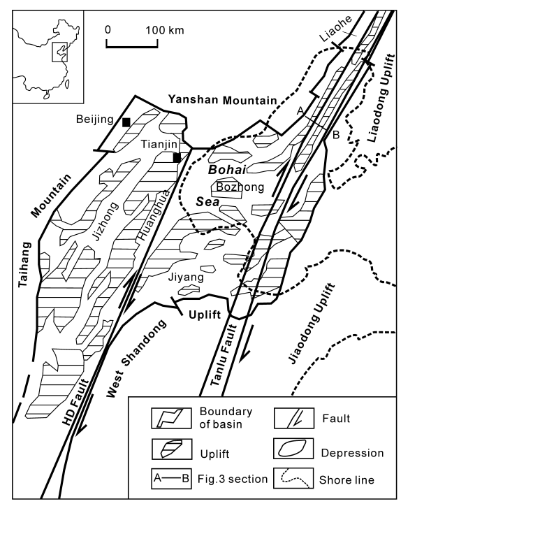
Tectonic divisions of the North China Basin (modified after Hu et al., 2001; Lu et al., 1997) HD Fault-Huanghua-Dongming strike-slip fault
Table 1. Summary of the stratigraphy and tectonic evolution of the North China Basin

Depressions within the basin mostly take the form of half-grabens with the geometry of Cenozoic successions controlled by listric master faults (Ye et al., 1985; Lu et al., 1997; Allen et al., 1997). The dominant structures of the North China Basin are WNW and E-W trending uplifts and depressions in the central basin, and NNE trending uplifts and depressions in the eastern and western parts. Tanlu Fault develops in the east of the basin while Huanghua-Dongming Fault develops in the center of the basin (Hou et al., 2001; Hu et al., 2001) (Figure 1). Syn-rift deposits rest on pre-rift basement and are covered by the post-rift deposition. The North China Basin experienced a typical rifting sequence from tectonic subsidence to thermal subsidence, which has a pull-apart basin pattern, however, the Mesozoic and Cenozoic evolution of its offshore portion (Bohai Sea area) remains ambiguous.