The use of GIS is widely recognized worldwide due to the linking of spatial information with attribute data in the underlying database. GIS can be used in almost all fields of life including mining and earth sciences, archaeology, agriculture, banking, defense and intelligence, engineering surveying, federal government, Fire/EMS/disaster/homeland security, forestry, health and human services, insurance, education, landscape architecture, law enforcement and criminal justice, libraries and museums, location services, state and local government, telecommunication, transportation, water and wastewater, geology and hydrogeology, natural resource management, population forecasting, facilities management, etc.
The application of GIS in natural resource management organizations has become commonplace during the last decade. Part of the reason for this widespread use is due to the analytical efficiencies GIS provides, but it is also due to the continued technological advances in computer hardware and software. Computer prices, in fact, continue to decrease while processing power and storage efficiency grow. A wide variety of GIS software programs have also emerged, and the trend in GIS software program design has been to make the programs more user-friendly. As most of the natural resource issues have a significant spatial component and GIS can be used extensively to visualize, analyze, and model natural resource data for management and problem solving.
A comprehensive and interactive GIS was developed for the natural resource management of Pakistan using ESRI ArcView© GIS and ESRI ArcInfo©. ESRI Arcview© is a powerful, easy-to-use desktop mapping software tool that provides the power to visualize, explore, query and analyze data spatially. In the first phase, infrastructure of Pakistan including provinces, districts of Pakistan and Azad Jammu and Kashmir, major rivers, offshore boundary of Pakistan etc. have been included. Furthermore, major geological structures, mineral deposits and mines, Seismo-tectonics along with associated geological structures and minerals, Seismo-tectonics of Pakistan including the areas that have suffered great damage from the earthquakes in past, all major earthquake epicenters and oil and gas wells drilled so far along with other upstream petroleum activities were included. The summary of all these data has been mentioned in Table 1 and 2. (Figure 1) shows the overall methodology adopted for building the GIS for natural resources of Pakistan.
Table 1. Table summarizing the details of natural resource themes
| Sr. No. | Theme Name | Feature Type | Feature Description | Attribute Data | Source |
|---|---|---|---|---|---|
| 1. | Upstream Petroleum Activities | Point | Oil and gas wells along with other upstream petroleum activities | SegID, Well name, operating company, and age of objective formation, rig description, well type, concession name, SPUD date, drilled depth, target depth and present operation | Hard copy map of Upstream Petroleum Activities, September 2004 published by LMK Resources in collaboration with DGPC and PPEPCA. |
| 2. | Earthquake Epicenters | Point | Epicenters of major earthquakes. This theme contains one thousand and twenty two earthquake epicenters. | SegID, Magnitude of the earthquake and its depth in km. | Preliminary Seismo-tectonic Map of Pakistan, issued by the Geological Survey of Pakistan in 1979. |
| 3. | Areas Suffered from Earthquake Damage | Polygon | Areas that have suffered from the earthquake damage in past. The polygons are drawn on the basis of their classification in the area of Major Earthquake Damage and the Epicentral Tract of Major Earthquake Serious Damage to Building. | SegID, Area name | Preliminary Seismo-tectonic Map of Pakistan, issued by Geological Survey of Pakistan in 1979. |
| 4. | Major Structural Features of Pakistan | Line | Major structural features including thrust, reverse, strike slip, and undifferentiated faults, and traces of probable recent faults, active faults and their lineaments. | SegID, Name of Fault and its type | Preliminary Seismo-tectonic Map of Pakistan, issued by Geological Survey of Pakistan in 1979. |
| 5. | Major Minerals of Pakistan | Point | Major minerals explored in Pakistan including antimony, arsenic, copper, manganese, gold/silver, mica, gypsum, coal, fire clay deposits etc. | SegID and Mineral Name | Map titled ‘Mineral Deposits’ by A. H. Kazmi, published in ‘Metallogeny and Mineral Deposits of Pakistan’ by Ali H. Kazmi and Syed Ghazanfar Abbas in year 2001. |
Table 2. Table summarizing the details of infrastructure themes.
| Sr. No. | Theme Name | Feature Type | Feature Description | Attribute Data | Source |
|---|---|---|---|---|---|
| 1. | Boundary of Pakistan | Line | Onshore and offshore boundary of Pakistan | SegID, Segment Name | Map of Area and Population of Pakistan (district and province-wise) in year 2003, by Survey of Pakistan. |
| 2. | Provinces of Pakistan | Polygon | Provinces of Pakistan | SegID, Province name, Total area, Population and the number of districts in the province | Map of Area and Population of Pakistan (district and province-wise), in year 2003, by Survey of Pakistan. |
| 3. | Districts of Pakistan | Polygon | Districts of Pakistan | SegID, District name, Area in square kilometer, Population and province name | Map of Area and Population of Pakistan (district and province-wise) in year 2003, by the Survey of Pakistan. |
| 4. | Districts of Azad Jammu & Kashmir | Polygon | District of Azad Jammu and Kashmir | SegID and District name | Map of Area and Population of Pakistan (district and province-wise) in year 2003, by Survey of Pakistan. |
| 5. | Major Cities of Pakistan | Point | Major cities of Pakistan | SegID and City name Preliminary Seismo-tectonic | Map of Pakistan, issued by Geological Survey of Pakistan in 1979. |
| 6. | Rivers of Pakistan | Line | Rivers of Pakistan | SegID and River name | Map of Area and Population of Pakistan (district and province-wise) in year 2003 by Survey of Pakistan. |
Figure 1. Overall methodology
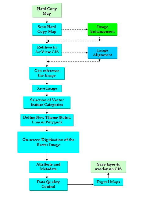
Workflow adopted for the development of GIS for natural resource management of Pakistan.