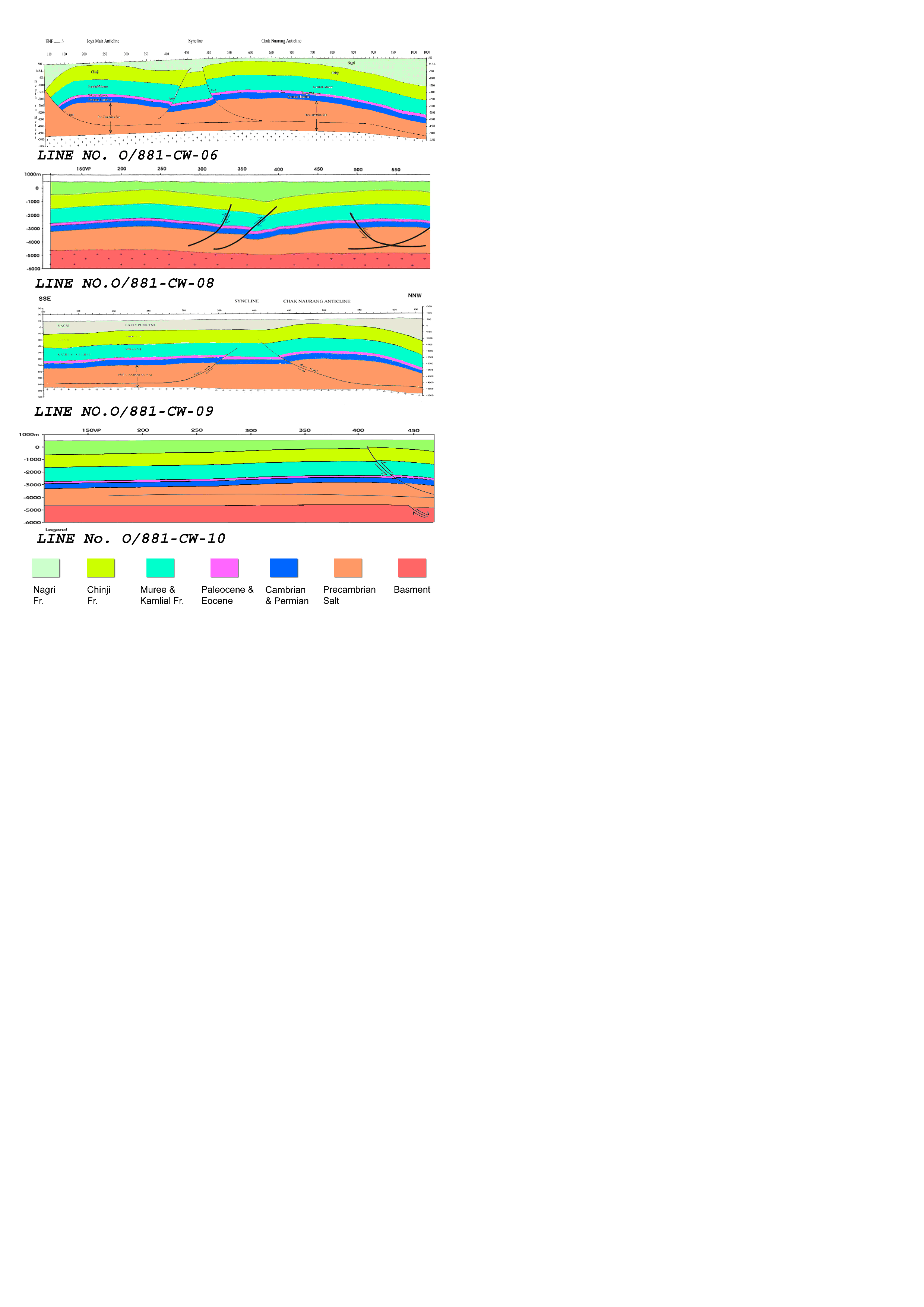
2D-Seismic interpretation of Chak Naurang and Joya Mair area has been carried out with the objectives to delineate the subsurface structure and to locate the prospective zones. To achieve these objectives, reinterpretation of four seismic lines O/881-CW-06 (Strike line) and O/881-CW-08, O/881-CW-09, and O/881-CW-10 (Dip lines) were carried out. These lines were shot during the seismic survey conducted by OGDCL in 1988. The purpose of the survey was to locate the prospective zones in the anticlines of Chak Naurang and Joya Mair and to understand the role of fault-propagating folds in hydrocarbon entrapment. The base map (Figure 2)shows the seismic lines under study and location of nearby wells whose data has also been employed in the interpretation of this study. The interpreted seismic sections along the seismic lines O/881-CW-06, O/881-CW-08, O/881-CW-09, and O/881-CW-10 have been shown in (Figure 3).
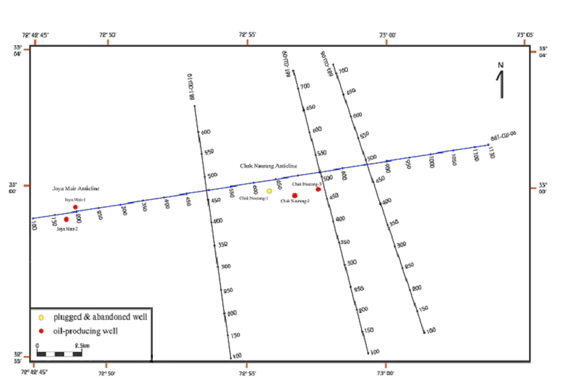
Figure 3. Interpreted seismic sections
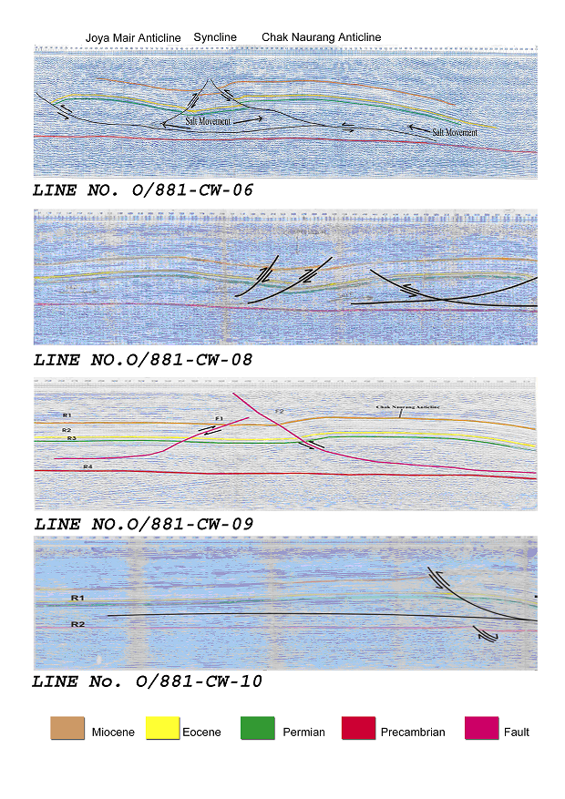
Interpreted seismic sections along the seismic lines O/881-CW-06, O/881-CW-08, O/881-CW-09, and O/881-CW-10
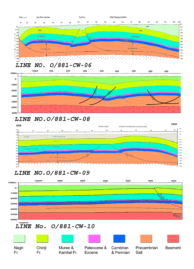
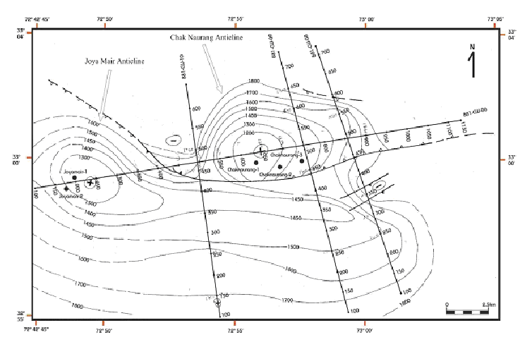
Four prominent reflectors namely R1, R2, R3 and R4 were marked on the seismic sections on the basis of observed reflection events. These reflectors were interpreted as Kamlial Formation (Miocene), the target horizon of Chorgali Formation (Top Eocene), a very thin layer of Permian age and the basement consisted of Pre-Cambrian salt respectively. A fault was marked which continued along the Pre-Cambrian basement. Two more thrust faults were marked which showed fault-propagating folds in the form of anticlines of Chak Naurang and Joya Mair. The geoseismic sections along the seismic lines under study have been shown in (Figure 4). Average velocities of the Upper Eocene Chorgali Formation and the Pre-Cambrian basement were used to find the depths of the formations for the geoseismic section. Well data of Joya Mair was used to mark the thickness of the individual formations on the geoseismic section from Cambrian to Recent. The geoseismic section showed that the area was structurally deformed due to salt decollement and compressional tectonic movements. On the Geoseismic Section of line O/881-CW-06 the Upper Eocene formation, which is our target horizon, is almost at a depth of 2000 meters within the anticlines of Chak Naurang and Joya Mair, which is favorable for drilling. The TWT were also posted on the base map to develop a time contour map for the Upper Eocene Chorgali Formation, as it was continuing throughout the study area (Figure 5).
Balancing of depth sections using Fixed Pole method for dip lines help to know the mechanism of the tectonic movements in the area. The major causes have been the thrust faults in the area that invoked the basement salt movement and eventually form the anticlines (as they truncated against the basement fault). Salt probably moved into these anticlines due to compressional movements and a syncline was formed. Hydrocarbon traps were probably developed in these anticlines and might be the prospective zones for hydrocarbons in Chak Naurang and Joya Mair area.
As mentioned earlier, POL delineated the Joya Mair Oilfield as structural trap on the basis of surface geology and seismic data. According to POL, Joya Mair structure is a simple anticline. The current study based on geophysical techniques negates the POL findings and suggests that Joya Mair anticline is not a single structure but it is faulted into blocks. The thrust and back thrust in the study area have been developed due to the stresses which are caused by the collision of Indian and Eurasian plates and the presence of salt, incompetent strata and basement fault. Shami and Baig (2002) also suggest that Joya Mair structure is not a simple anticline, it is a triangle zone, which is formed by the combination of Mengan thrust and Joya Mair thrust resulting in the triangle geometry at subsurface and faulted anticline structure. Khan and Ali (1994) indicated similar structures in the northern Potwar near Rawalpindi, which are Rawat thrust and Kahutta backthrust. They suggested that Rawat thrust and Kahutta backthrust have been developed due to SSE ward stress, decollement and the extensional basement fault present in the upper crystalline basement. Basharat et al. (2004) carried out an integrated gravity and magnetic survey for the modelling of Joya Mair structure (Figure 6). They concluded that faults F1 and F2 deformed the structural trap in Joya Mair area. It also indicates that Joya Mair anticline is not a single structure but it is faulted into blocks, due to which the expected reserves potential of Joya Mair Oilfield are not recovered so for.
Figure 6. Joya Mair area
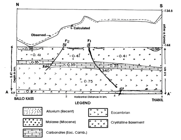
Gravity modelling from Ballo Kass to Thanil Fatui in Joya Mair area (After Basharat et al., 2004).