As illustrated by Figure 1, many earthquake monitoring web sites present focal mechanism data using line-printer style output reminiscent of the earliest computer graphics. Some sites – notably the USGS and General Mapping Tools – employ sophisticated graphical interfaces and advanced visualization tools, but results are usually presented as static jpeg files that are not editable or linked to the source data. A survey of web sites in Table 1 demonstrates that the presentation of focal mechanism solutions is widespread but not generally graphically sophisticated. Determination of focal mechanisms for major earthquakes and their aftershocks is critical to our understanding of neotectonics (e.g., McNutt & Sánchez, 2000, Lisa, et al. 2004). Indeed, this may be a matter of life and death, as tsunamigenic earthquakes exhibit characteristic focal mechanisms as well as magnitudes. Rapid publication of moment tensor solutions in a graphical format that is easily understood by public safety officials and citizens is thus a priority. We therefore undertook a programming project to facilitate the construction of focal mechanism solutions (so-called geophysical beach balls) through an interactive web-based flash movie, and to overlain multiple moment tensor solutions on maps using real-time monitoring of data stored in XML files on the Internet.
In the first of a planned series of papers, we here present a focal mechanism generator for use with raw first arrival data. Subsequent papers will enable rendering of multiple (tens or hundreds) of moment tensor solutions on a background map, and will address the incorporation of moment tensor solutions into klm / kmz files viewable with Google Earth™ software. This undergraduate research opportunity was funded by a grant from the National Science Foundation, EAR 0310232: "Real-time Monitoring, Enhanced Visualization and Temporal Analysis of Tectonic and Geophysical Data."
Figure 1. Screens
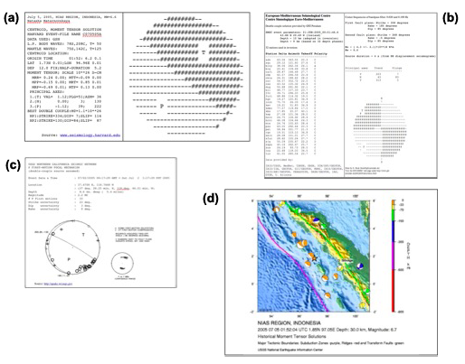
a) Focal mechanism output from Harvard Seismological Group http://www.seismology.harvard.edu
b) Data from USGS Earthquake Hazards Program http://www.quake.wr.usgs.gov
c) Focal mechanism output from GEOFON program at Potsdam http://www.gfz-potsdam.de/geofon
d) Jpeg map with beach balls from USGS (http://neic.usgs.gov)
Sample web sites featuring focal mechanism solutions
http://www.seismology.harvard.edu/~smith/postscript/jointinv/out8.gif
http://www.seismo.unr.edu/htdocs/WGB/InclineVillage98/figure1.gif
http://pubs.usgs.gov/of/2002/ofr-02-0073/images/Slides22.gif
http://www.hinet.bosai.go.jp/topics/niigata041023/mechanisms_j.html
http://www-geology.ucdavis.edu/~gps/GMT/LONG_VALLEY/LV_focal_mech.JPG
http://www.earth.sinica.edu.tw/~smdmc/recent/2002/special_eqk.jpg
http://www-seis.planet.sci.kobe-u.ac.jp/~harada/hypoDD.epi.jpg
http://www-geology.ucdavis.edu/~gps/GMT/LONG_VALLEY/hypocenter.html
http://www.seismo.unr.edu/htdocs/WGB/InclineVillage98/figure1.gif