The objective of this paper is to make the current level of understanding of the Brasiliano Orogens of southeast and south Brazil (Figure 1) available to the international community. Many publications of local or general importance tend to be published within Brazil, in Portuguese. This creates a difficulty of access for foreign researchers that fortunately is diminishing over the last few years. A recent effort to overcome this problem was the publication of the book "Tectonic Evolution of South America" on the occasion of the 31st International Geological Congress in Rio de Janeiro, 2000 [Cordani et al., 2000)].
Figure 1. Tectonic map of South America
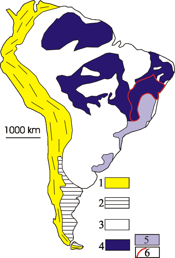
Tectonic map of South America, modified from Almeida and Hasui (1984) and Trompette (1994). 1- Andean orogenic system; 2- Patagonian terrane; 3- Phanerozoic cover of the South American Platform; 4- Shields in the South American Platform, highlighting the Mantiqueira Province (5) and the São Francisco Craton (6).
However, many new data have become available over the last four to five years and a new overview is justified. In Brazil this new overview is currently being prepared in the form of a book to be published in homage to Professor Fernando Flávio Marques de Almeida, but this book will be in Portuguese. His major contributions to the tectonic subdivision of the Brazilian Precambrian Provinces are Almeida (1956, 1977, 1993), Almeida et al. (1973,1977,1981) and Almeida and Litwinski (1984). Other important contributions to the subject are Brito Neves and Cordani (1991), Trompette (1994), Campos Neto (2000), Heilbron et al. (2000), Trouw et al. (2000), Silva et al. (2005), Campos Neto et al. (2005). The present paper coincides to a large extent with the chapter on the Mantiqueira Province of that book [Heilbron et al., 2004]. Since the concept of this province is not essential to the understanding of the Brasiliano belts or orogens no emphasis is given to this province for reasons of simplicity.
Within the region considered here, the following mobile belts or orogens may be distinguished from NE to SW: Araçuaí, Ribeira, Dom Feliciano and São Gabriel, being the central part of the Ribeira Orogen characterized by a zone of interference with the southern segment of the Brasília Orogen (Figure 2 and 3). All the geochronological subdivisions adopted in the text are based on recent U-Pb TIMS, SIMS and SHRIMP data.
Figure 2. Location of the orogens
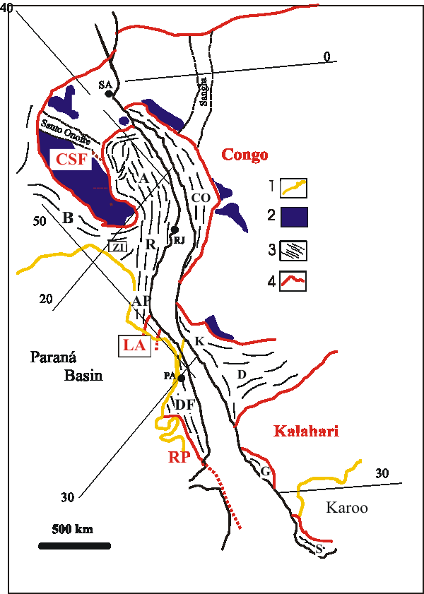
Location of the orogens discussed in this paper in the tectonic setting of Western Gondwana (modified from Trompette, 1994).
Phanerozoic basins;
Cratonic cover;
Neoproterozoic orogens: B- Brasília, A- Araçuaí, R- Ribeira, ZI- Zone of Interference, AP- Apiaí Terrane, DF- Dom Feliciano;
Cratons during the Neoproterozoic: CSF- São Francisco, LA- Luis Alves, RP- Rio de la Plata. Neoproterozoic belts in Africa: West Congo (CO), Kaoko (K), Damara (D), Gariep (G) and Saldania (S). RJ is Rio de Janeiro.
Hairlines and numbers refer to rotated longitudes and latitudes, note their different orientations for the South America and Africa due to different rotations.
Figure 3. Location of the orogens
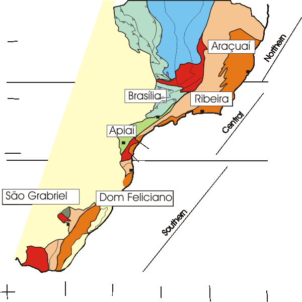
Location of the orogens described in this paper: the northern segment is the Araçuaí Orogen; the central segment includes the southern tip of the Brasília Orogen and the Ribeira Orogen, including the Apiaí Terrane; and the southern segment includes the Dom Feliciano and São Gabriel Orogens. Deep orange and purple indicate terranes with Neoproterozoic magmatic arcs.