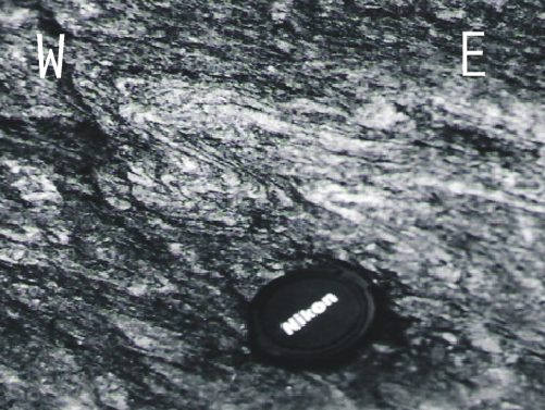
Two sets of structures are reported in the inner zone (Estrondo Group and Colméia Complex): a thrust fabric and a wrench fabric. The thrust fabric comprises a gentle east/southeast dipping gneissic banding or foliation (S1) that strikes N-S. This is the most conspicuous and widespread structure (Figure 5a). This N-S striking foliation is axial planar to rare mesoscopic asymmetric F1 folds. Recognition of bedding, however is quite difficult. Bedding was probably transposed during the initial stages of contractional deformation, so identification of F1 folds remains tentative.
Figure 5. Stereonet lower hemisphere projection
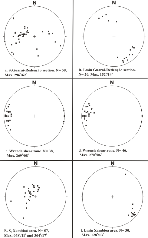
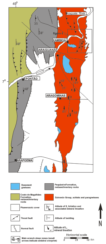
Stereonet lower hemisphere projection of structural data of the Guaraí-Redenção section and Xambioá area. a) Poles to foliation of Estrondo Group schists and gneisses; b) mineral stretching lineation, Estrondo Group schists; c) S2 poles to foliation related to wrench shear zone west of Pequizeiro; d) S2 poles to foliation related to a shear zone NW of the previous zone along the road TO 376; e) poles to S1 foliation of Estrondo Group schists and gneisses, Xambioá area; f) mineral stretching lineation, Estrondo Group schists, Xambioá area.
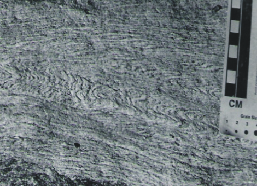
Common F2 asymmetric flexural flow folds (Fig. 6a) fold the gneissic banding / cleavage. They probably represent later stages of regional contractional deformation, for they fold millimeter to meter-scale pre to syn-kinematic quartz veins. A N-S and east dipping spaced cleavage is also present which is axial plane to the F2 folds. Sometimes, the F2 folds have sheath-like forms. Asymmetric centimeter-scale folds are common and represent parasitic folds of larger scale regional asymmetric folds.
Figure 6. Common F2 asymmetric flexural flow folds
F2 west-verging asymmetrical folds affecting gneissic foliation. Estrondo Group gneiss, outcrop along the road Guaraí-Colméia
A second set of vertical cleavage planes locally transposes the first S1 contractional fabric. Outcrop at the Britador quarry (8o 35' 39''S; 48o 51´ 50´´W).
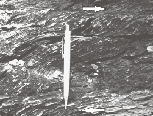
S-C fabric at a vertical dextral shear zone. Road Guaraí-Colméia.
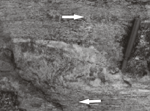
Z-shaped mesoscopic fold indicating dextral movement in a vertical shear zone. Biotite gneiss exposed at an abandoned quarry flat exposure. Road Pequizeiro-Presidente Kennedy (8o 29' 10''S; 48o 34´ 26´´W).
Quartz stretching lineations are associated with S1. They consistently plunge gently to SSE (150-160o) on east-dipping planes (Figure 5b). The recorded rake of the lineation on the foliation plane is about 50-60o towards the south, thus suggesting an oblique movement component. Kinematic indicators such as sigmoidal fabric geometry consistently indicate top to N-NW, as previously described by Hasui and Costa (1990) and Abreu et al. (1994).
The second set of structures truncates the early thrust fabrics. It consists of a series of north-south ductile-brittle wrench zones. The shear zones, which overprint the gneissic banding, are up to 50m in width and are well developed in both the eastern and western limbs of the Colméia dome. Folds with vertical axis with an associated spaced cleavage locally transpose the gneissic banding (Figure 6b). Kinematic indicators, such as asymmetric Z shaped folds and S/C fabric (Figure 6c) indicate dextral shear sense.
Three wrench fault zones are best exposed along the west limb of the Colméia dome (Figure 3). The first zone crops out at the Britador quarry, at the margin of the Barreiras river (8o 35' 39''S; 48o 51´ 50´´W). The rock at this quarry consists of felsic migmatitic gneiss with quartz-feldspar leucosomes displaying a complex folding pattern. The wrench zone trends north-south and is vertical with horizontal stretching lineations. Strike-slip movement is also indicated by S/C foliations that cut the gneissic banding. At least two additional shear zones can be recognized along the TO 376 road. Both zones (8o 32' 12''S; 49o 00' 35''W and 8o 32' 37''S; 48o 58' 05''W) affect the Estrondo rocks and display vertical S/C fabrics, with C surfaces trending north and horizontal lineations (Figure 5c,d). Another vertical dextral shear zone was identified on the eastern limb of the Colméia Dome. It is located west of the town of Presidente Kennedy (8o 27' 50''S; 48o 35' 44''W) and cuts biotite gneisses. S/C structures are weakly developed but dextral sense of shear is clearly indicated by centimeter-scale Z-shape flexural folds, with vertical hinges (Figure 6d).
Extensional brittle structures were also recorded in the inner zone. They affect schists and metasandstones of the Estrondo Group. Centimeter-scale asymmetrically boudinaged veins indicate hangingwall-down to southeast, east of the Colméia dome. Towards the north, these veins are also observed and still indicate normal movements. At the southern boundary of the Lontra dome, the veins cross-cut metasandstones of the Morro do Campo Formation (Estrondo Group) also indicating normal movement to the south. The significance of this normal set of brittle structures is still unclear.
Normal faults bordering the Xambioá dome are also common. Excellent exposures of normal faults that indicate top-down to the NNW can be observed along the road cuts, 3 km south of Xambioá, along the road TO 388 (Figure 7).
Figure 7. Central portion of the Araguaia Belt
Central portion of the Araguaia Belt (Xambioá area) with location of the main F2 shear zones. See Fig. 2 for location. Geology after Silva et al. (1974).
In the low-grade outer zone, a single set of thrust-sense structures, recording east-west shortening, is observed. Metapelites in this zone exhibit a slaty or spaced cleavage. Its relation to bedding indicates the presence of regional-scale asymmetric folds, but fold hinges have not been identified. A positive Bouguer gravity anomaly (Carvalho, 1988) from Conceição do Araguaia (approximately in the transition between the inner and outer zones) to the west suggests that basement is shallower in the outer zone compared with the inner zone. The relation between the ultramafic bodies and supracrustal rocks of the Tocantins group is unclear, however the presence of mylonitic foliation along the border of the Quatipuru complex favors a tectonic relationship (Gorayeb, 1989).
N-S trending shear zones mapped along the Guaraí-Redenção profile can also be recognized in the northern part of the Araguaia Belt (Figure 7) where they are well developed east of Arapoema (7o 39' 61''S; 49o 00' 65''W). There, gneisses of the Estrondo Group exhibit meter-scale dextral shear zones. Figure 2 shows that this zone is located immediately north of the previously described zones, along the same meridian as the wrench zones mapped near Pequizeiro.
Farther north, wrench shear zones are conspicuous east and northeast of Aragominas (Figure 7, herein named Xambioá area). The regional structure of the Xambioá area is strongly controlled by the presence of two domes, the Xambioá to the north and the Lontra dome to the south. Previous structural studies indicate thrust contacts between domes and supracrustal rocks of the Estrondo Group (e.g. Santos and Costa, 1995). However, we re-examined the contacts and found that they actually represent high-angle normal faults. Effectively, the Estrondo Group forms a keel between both domes. The Estrondo rocks record also thrust faults and F1 and F2 mesoscopic folds that verge to the west. S1 foliation trends NNE and NS, with mineral lineation plunging to the southeast, thus confirming the oblique character of the thrust fabric (Figure 5 e, f).
Strongly sheared shallowly dipping gneissic banding is truncated by a vertical set of high-angle dextral shear zones at the Umuarama quarry (east of Aragominas, 7o 11' 71''S; 48o 26' 68''W, Figure 7). Schists and gneisses of the Estrondo Group are cross cut by vertical shear zones with evidence of sinistral reactivation of dextral fabrics northeast of Aragominas (6o 55' 68''S; 48o 28' 48''W). The meaning of this sinistral fabric is still unclear.
These high angle shear zones represent the northward extension of those mapped between Itaporá and President Kennedy, ca 200 km to the south (Figure 2). This confirms the regional extent of the wrench tectonics.
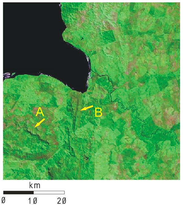
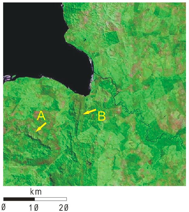
The wrench shear zones of the Araguaia belt are not visible in satellite images as the shear zones in the Borborema. North-south lineaments on Landasat TM images (Miranda and Coutinho, 2004) of the Xambioá dome area (Figure 8) were mapped as west-verging thrusts of the first deformation phase.
Figure 8. Landsat TM image of the Xambioá dome area
Landsat TM image of the Xambioá dome area (Miranda & Coutinho, 2004). Arrow A indicates the Xambioá Dome and B indicates north-south lineaments mapped as west-verging D1 thrusts that cut across metasedimentary rocks of the Estrondo Group. Wrench shear zones of the Araguaia belt are not visible in satellite images, unlike those of the wrench shear zones in the Borborema. See Fig. 7 for location.
Recent models involving the triple collision among West African, São Francisco Congo and Amazonian cratons have been proposed by Castaing et al. (1993, 1994), Alkmim and Fonseca (1998) and Alkmim et al. (2001). All these models propose that the collision caused oblique tectonics, mainly recorded by the network of dextral shear zones exposed in the Borborema Province. This network of dextral shear zones in the Borborema Province is just a small part of a much greater orogen, the Brasiliano-Pan African chain (Figure 9). This orogen includes major strike-slip component ductile shear zones that rework basement fragments and affect supracrustal rocks (Borborema, Nigerian and Central African Provinces) and metasedimentary frontal thrust fold belts facing the São Francisco Craton (Sergipano and Oubanguides Fold Belts) to the south and the West African Craton (Dahomehides and Gourma Fold Belts).
Figure 9. Tentative correlation between the Araguaia fold belt
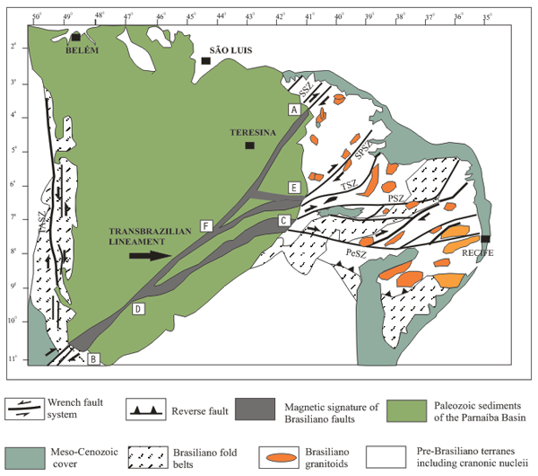
Tentative correlation between the Araguaia fold belt wrench structures and the Borborema Province. Structures of the Borborema Province after Vauchez et al. (1995). Magnetic signature of the wrench structures after Goes et al. (1993). All transcurrent structures root at the Transbrasilian Lineament beneath the Parnaíba Basin and merge in the SW corner of the Araguaia Belt. The Araguaia Belt represents a physically independent fault array. Note that most of the Parnaíba Basin lies upon an area not apparently affected by the Brasiliano-Panafrican tectonism, thus extending to SE the limits of the West African Craton. Main Shear Zones: SSZ: Sobral; SPSZ: Senador Pompeu; TSZ: Tatajuba; PSZ: Patos; PeSZ: Pernambuco; TASZ: Tocantins-Araguaia Shear Zone.
The correlation between the Borborema fault array and the north-south wrench structures of the Araguaia Belt, however, is concealed beneath the Parnaíba Paleozoic Basin (Figure 1). To search for a possible correlation, we used magnetic data on the structure of the Parnaíba Basin presented by Goes et al. (1993). Magnetic data suggest that the 4o 50´ Hoggar ductile lineament in Africa traces to the southwest into Brazil (herein named Sobral lineament), and reaches the Parnaíba basin at its NE corner (parallel 4o, point A in Figure 9, Vauchez et al., 1995). Its magnetic signature runs S 50o W and emerges at the southern boundary of the Araguaia Belt (parallel 11o, point B in Figure 9, and Figure 2). The array of wrench fault zones in the Central Chain (Borborema Province) as proposed by Vauchez et al. (1992) may be traced westwards as follows: the Potengi Shear Zone (western extension of the Patos Shear Zone) merges the Pernambuco Shear Zone (C in Figure 9) and then trends to S 60o W, rooting into the Transbrazilian lineament at 46o 30' W/9o 30´S, (D in Figure 9). The Senador Pompeu Shear Zone joins the Tatajuba Shear Zone (E in Figure 9) and runs parallel to the Pernambuco Shear Zone, also rooting into the Transbrazilian Lineament at 44o W/8o S (F in Figure 9), with a small branch running EW at parallel 6 o.
Analysis of Figure 9 also shows that a great extension of the Parnaíba Basin (the area north of point B in Figure 9) is not affected by Brasiliano structures, suggesting that it represents a small Brasiliano cratonic block (the Parnaíba Block, see Figure 10 and compare with Figure 1).
Figure 10. The Araguaia Fold Belt
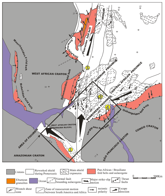
(numbers in filled yellow circles) as part of a continental-scale strike-slip system in the Neoproterozoic (simplified after Castaing et al., 1994).
Frontal Fold Belts facing the West African Craton.
Borborema, Nigerian and Central African Provinces: major strike-slip component ductile shear zones that rework basement fragments and affect supracrustal rocks.
Frontal Fold Belts facing the São Francisco Craton. In such reconstruction, the combined movement on the Araguaia-Borborema strike slip systems accommodated respectively northward and northeastward escape of wedged terranes between Amazonian and West African Cratons and São Francisco / Congo and West African Cratons.
In such a reconstruction, the set of north-south wrench faults of the inner zone of the Araguaia Belt would represent a shear corridor, located between the south-southwestern border of the West-African Craton and east Amazonia (Figure 10). This shear corridor, operating as another escape fault array, allowed the intervening material (the supracrustal units of the Araguaia between the two cratonic blocks) to squeeze northwards as the result of the transcurrent relative motion between Amazonian and The West African Craton. This shear movement between the Amazonian and São Francisco Craton was previously postulated by Castaing et al. (1994).
The age of this Brasiliano escape tectonics in the Borborema province is constrained by 40Ar/39Ar and U/Pb. 40Ar/39Ar plateau ages allow definition of homogeneous slow cooling between 580 and 500 Ma. Fast cooling around 500 Ma (related to significant uplift during lateral escape) is suggested by concordant plateau ages on muscovite and biotite ages (Corsini et al., 1988; Neves et.al., 2000). Alkmim et al. (2001) suggested the escape was late Brasiliano in age because the east-west related structures of the Borborema fault array truncate older structures related to São Francisco/de La Plata collision with Amazonia. The difference in metamorphism between the greenschist - amphibolite facies exposed rocks of the Araguaia belt and the amphibolite to granulite facies rocks exposed in the Borborema Province, may be related to a combination of exposure level and to regional variations in heat flux over this vast area.