Barbosa et al. (1966) and Almeida (1967) were the first to describe the Araguaia Belt which they called Paraguay-Araguaia Belt. These authors considered the belt to be an orogen extending for over 2500 km long bordering the Amazonian Craton. Now, the Araguaia Belt is considered to be separated from the Paraguay Belt by the Goiás Massif. The Araguaia Belt extends for over 1000 km from Marajó Island at the equator to 11o S latitude, and it borders the east side of the Amazon Craton (Figure 2). It is less than 150 km wide because it is covered eastward by sedimentary rocks of the Paleozoic Parnaíba Basin. The Paraguay Belt is a northwest-verging arcuate fold-thrust belt that lies along the southern margin of the Amazon Craton (Figure 1).
Figure 2. Geology of the Araguaia Belt
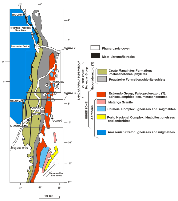
Geology of the Araguaia Belt (after Hasui & Costa, 1990. Moura & Gaudette, 1993). Dome structures: (1) Xambioá; (2) Lontra; (3) Grota Rica; (4) Cocalândia; (5) Cantão; (6) Rio Jardim; (7) Cunhas; (8) Colméia.
The Araguaia Belt may be divided into two main zones (Figure 2). The inner zone involves basement outcrops along a 250 km-long line of eight doubly-plunging anticlines (or domes). The basement occurs in the center of the domes and is surrounded by metamorphosed supracrustal rocks (metasedimentary rocks of the Estrondo Group). The largest dome is the Colméia Dome, an elongated body of 35 x 20 km. The next larger domes are the Xambioá dome (11 x 9 km) and the Lontra dome (20 x 9 km), which trend WNW, and are separated by a synformal keel of supracrustal rocks. Previous studies concerning the evolution of these domes suggest that they are either a result of crustal diapirism (Hasui et al., 1984; Santos et al., 1984) or that they simply are doubly plunging anticlines that resulted from SE-NW contraction (Costa, 1980; Hasui and Costa, 1990; Abreu et al., 1994; Santos and Costa, 1995).
Supracrustal units of the inner zone involve rocks of the Baixo Araguaia Supergroup divided into two units: the basal Estrondo Group and the upper Tocantins Group. Rocks of the Estrondo Group are sedimentary rocks metamorphosed up to amphibolite facies. According to Abreu and Hasui (1978) and Gorayeb (1989), the Estrondo Group can be divided into two formations. The basal one is the Morro do Campo Formation, consisting of orthoquartzites and micaceous quartzites with interbedded layers of biotite- schists and graphite-muscovite schists. Upwards, the Xambioá Formation includes muscovite-biotite schists with interbedded layers of amphibolite, quartzite and dolomite.
The outer zone borders the Amazonian Craton to the west. It is composed of psammites and pelites of the Tocantins Group that can be divided into two units. The basal unit is the Pequizeiro Formation that consists of quartz-chlorite schists and phyllites. The top formation is the Couto de Magalhães Formation that includes slates and phyllites with minor quartzites, metacherts and metacarbonate rocks. Within the western part of the zone, rocks are unmetamorphosed, and thus contrast markedly the amphibolite-grade rocks in the inner zone to the east. A prominent lineament occurs along the contact between the Araguaia Belt and the Amazonian craton. This feature, the Tocantins-Araguaia lineament (Figure 2), was first described by Kegel (1965). This lineament comprises a set of shear zones that separates the Amazonian Craton to the west, where structures visible on aerial photograph trend NW to EW and the Araguaia Belt to the east, where structures trend N-S. Almeida (1986) proposed that the lineament represents a zone containing various deep shear zones, extending over 850 km along the eastern border of the craton from latitude 10o 30' to 3o 30'S. According to Almeida (1986), most faults are concealed under the Baixo Araguaia sedimentary rocks and recent cover. However, local observations suggest that the southern segment is vertical whereas to the north, close to the Tucuruí Dam (4o S, 50o W, Figure 2) it dips eastward, becoming a thrust fault verging WNW and truncates metasedimentary rocks of the Tocantins Group (Trouw et al., 1976). The precise kinematics and age of the fault zone have not been determined. The fault also truncates mafic-ultramafic bodies (Figure 2) now schists and serpentinites. According to Gorayeb (1989), most ultramafic bodies display massive internal textures whereas the borders are generally brecciated or present mylonitic foliation parallel to the trend of Tocantins Group sedimentary rocks. Several authors consider the mafic and ultramafic bodies to represent fragments of ophiolite sequences (Gorayeb, 1989; Souza et al., 1995; Teixeira, 1996; Kotschoubey et al., 1996) related to the Brasiliano orogeny.
Although an understanding of the Araguaia Belt is essential for developing models for the assembly of Gondwana, there are few reliable radiometric dates on rocks of the belt. Most published ages were obtained by K/Ar and Rb/Sr dating techniques. There are a few Sm/Nd and some Pb/Pb ages available but no Ar/Ar and U/Pb ages. Sm/Nd model ages (Tdm, whole rock) for the basement rocks range between 3.4 and 2.9 Ga. (Cordani & Sato, 1999; Moura & Gaudette, 1993). Moura & Gaudette (1993) also obtained a date of 2.85 Ga using Pb/Pb method. These data suggest that the main period of basement protolith formation was in the Archean. K/Ar and Rb/Sr dates (Hasui et al., 1980) indicate reworking during the Paleoproterozoic (1.8 Ma) and Neoproterozoic (0.5 Ma).
A 2085 Ma Pb/Pb age for gneisses in the southern portion of the Araguaia Belt (Souza and Moura, 1995; Moura and Souza, 1996) suggests that an episode of crustal accretion occurred during Paleoproterozoic. Paleoproterozoic crustal accretion or reworking (?) is also supported by a series of Rb/Sr and K/Ar ages (Hasui et al., 1980, Lafon et al., 1980). A Pb/Pb age of ca 1851±41 Ma was obtained for the Serrote granite at the southern segment of the Araguaia Belt (Sousa and Moura, 1995). Paleoproterozoic ages were also obtained for the basalts of the mafic/ultramafic units. Pb/Pb ages of 2083±4, 2062±3, 2052±5 and 2035±3 Ma for magmatic zircons indicate important magmatic activity (Gorayeb et al., 2001).
The age of deposition of the supracrustal units is still unknown. Because of the significant contrast in metamorphic and structural style between the Estrondo and Tocantins Groups, it appears that the units are not the same age, with the high grade Estrondo being older. Lafon et al (1980) obtained a Rb/Sr age of 497 Ma for the Ramal do Lontra granite which cuts the Estrondo rocks. Moura and Gaudette (1993) obtained Pb/Pb ages in single zircons of 583 72, 498 19 and 583 39 Ma in granite veins that also cut the Estrondo Group. K/Ar data only constrain cooling ages to be between 560 - 420 Ma (Hasui et al., 1975; Herz et al., 1989).
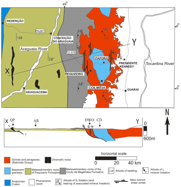
The geological section between the tows of Guaraí (Tocantins State) and Redenção (Pará State, Figure 3) is considered to be the type section of the Araguaia Belt. The section extends for 200 km along the state roads TO 376/PA 287. From west to east, the following lithologic assemblages are distinguished: the Colméia Complex, the Estrondo and Tocantins Groups.
Figure 3. Geology of the Guaraí-Redenção Section
See Fig. 2 for location. Geology after Silva et al. (1974). QP: Quatipuru ultramafic body; AR: Araguaia River; DWO: Dextral wrench overprint on west-verging contractional fabric; CD: Colméia Dome.
The Colméia Complex crops out in the core of Colméia Dome. The longest dome axis extends north-south for 35 km whereas the shortest axis extends east-west for 30 km. Along the major roads that cross this structure (TO 376 that connects the cities of Pequizeiro and Itaporá, Figure 3) no outcrops are found. At the Garrafa creek, south of city of Colméia, there is an excellent exposure of gneiss of the Colméia Complex that is crosscut by veins of granodioritic composition with incipient foliation. Along the same creek, Costa et al. (1988) described migmatitic tonalite and granite cut by small granitic veins.
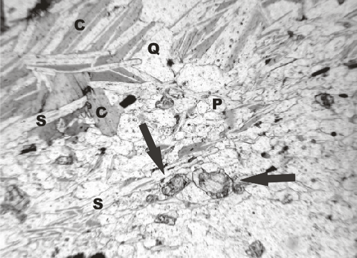
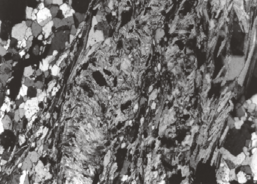
The Estrondo Group crops out in a 15 km-wide belt on both the east and west sides of the Colméia Complex (Figure 3). To the east, rocks of the Estrondo Group are covered by sediments of the Parnaíba basin. The Group consists of fine-grained banded gneisses and muscovite schists. The banded and locally folded gneiss is composed of millimeter-scale layers of biotite, plagioclase and epidote alternating with quartz ( plagioclase) layers (Figure 4a). The schist is comprised of chlorite-sericite-epidote rich layers (Figure 4b) and quartz carbonate veins/lenses with variable plagioclase contents. A cleavage parallels banding. Locally, a spaced cleavage transposes the banding and the older cleavage (Figure 4c).
Figure 4. Photomicrographs
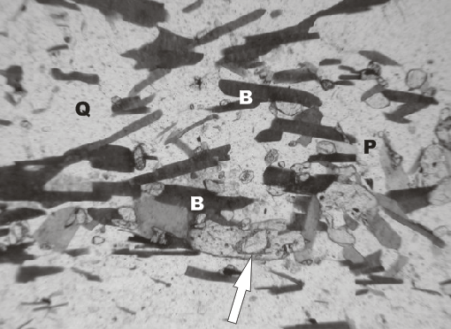
Long dimension of the field of view is 1.8 mm.
Gneiss of the Estrondo Group unaffected by shearing. B: biotite; P: plagioclase; Q: quartz. Notice zoned epidote (arrow) with allanite core similar to epidote found in schists (compare to b). Plane polarized light.
Schist of the Estrondo Group derived by retrograde metamorphism and shearing of gneiss in (a). C: chlorite; S: sericite. Notice zoned epidote (arrows) which survived shearing and retrogression, suggesting derivation of the schist at the expenses of the gneiss Plane polarized light.
Chlorite-plagioclase-sericite-quartz schist of the Estrondo Group showing a crenulation cleavage developed during shearing associated with the vertical wrench zones. Crossed polarized light.
Gneisses of the Estrondo Group have higher proportion of feldspar and biotite while schists have higher proportion of white mica and chlorite. The mean mineralogical composition (vol %) of the gneiss is: plagioclase 35, quartz 30, biotite 20, white mica 5, epidote 8, carbonate 2. Schists are made up of white mica 35, quartz 25, chlorite 15, plagioclase 10, biotite 5, epidote 5, and carbonate 5. Microcline is found in only a few gneiss samples. Accessory minerals are tourmaline, opaque minerals, apatite, zircon, and rare titanite and garnet. The mineral paragenesis biotite + quartz + plagioclase + microcline + epidote found in the gneiss belongs to the lower amphibolite facies.
In the shear zones, gneiss was transformed into schist during folding, transposition of the older foliation and generation of a spaced cleavage under lower greenschist facies conditions. Shearing was accompanied by infiltration of H2O - CO2-rich fluid phase, leading to sericitization of feldspars, chloritization of biotite and generation of quartz and carbonate veins and lenses. There are two lines of evidence that schists were generated at the expenses of the gneisses. The first one is that zoned epidote with allanite nucleii are found in both rock types (Figures 4a and 4b). The second is the presence of rocks transitional between gneiss and schist, where biotite and plagioclase are only partially converted into chlorite and white mica, respectively, representing incomplete retrogression. Therefore, one may conclude that the schist was generated by retrograde metamorphism of gneiss in the shear zones, thus not representing the prograde metamorphic equivalent of sedimentary rocks.
The Tocantins Group (outer zone) crops out for ca 100 km from west of Pequizeiro to nearby Redenção (Figure 3). The rocks are poorly exposed due to deep weathering and flat relief. The best exposures occur in road cuts and in the Serra de São José, 5 km west of Conceição do Araguaia. Slates, phyllites, metasiltites, metasandstones and carbonates form the Tocantins Group. Metamorphism reaches the lower greenschist facies and is absent to the west. The rocks are cut by fine-grained diabases dykes with subophitic textures.
Ultramafic and mafic sequences of unknown age, crops out at the Serra do Quatipuru as well as northwest of Araguacema (Figure 3) in the form of an elongated body. They represent slices of an ophiolite sequence thrusted over the metasedimentary rocks of the Tocantins Group (Teixeira, 1996). The Quatipuru complex is 45 km long and 1-5 km wide and is composed of harzburgites, pods of dunites, massive basalts and pillows basalts at the top. Gorayeb (1989) reports that the body has a regional dip of around 45o to the east and that mylonitic textures occur along the contact with other units.