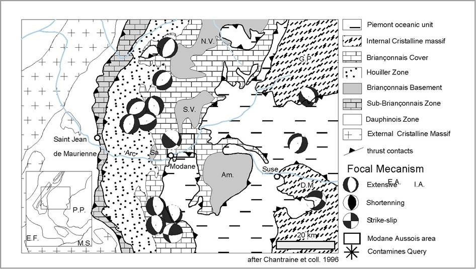
We present a structural scheme of the Vanoise that includes a synthesis of the faults described on the 1/50 000 geological map of Modane, Lanslebourg, Tignes, Moutier and Bardonecchia, the 1/100 000 map of the Vanoise National Parc (Debelmas and Rampnoux, 1995) and the 1/1 000 000 Geological map of France (Chantraine et al., 1996). On the basis of orientations and motion histories, the post-metamorphic faults have been classified in four groups. Geometrical relationships between these faults allow us to propose a relative chronology: the faults from the first group are the most recent, those from the second and the third groups may be synchronous and the faults from the fourth group are the oldest.
The first group is composed of N-S faults (a, b, c; Figure 1) 2) that show two successive motions: the first one is sinistral strike slip and the second one is normal. The Modane-Chavière fault (a. on Figure 1) 2, Ellenberger, 1958) stretches for more than 20 km (Fudral, 1998) and underlines in many places the contact between the Houiller zone and the Briançonnais zone of the Vanoise. Another unamed fault (b) underlines the contact between the Briançonnais zone of Vanoise and the Schistes Lustrés unit.
Figure 2. Structural scheme of the Vanoise
Structural scheme of the Vanoise including a synthesis of the main post-metamorphic fault (a, b, c, d, e, f, g, h, I, j, k, l, m) and the focal mechanism that occurred since 10 years in the internal domain.
The second group consists of NW-SE faults (d, e, f, g and h; Figure 1) 2) that also records two successive motions: the first one is a dextral strike slip and the second one is normal (e.g. Malusa 2004). This group includes the Modane Termignon fault (f) (Fudral, 1998) that forms the south eastern limit of the Southern Vanoise dome, the Susa fault (g) (Malusa 2004) that underlines the southeastern limit of the Ambin dome and the col de la Vanoise and col du Chardonnet fault (e) that forms the southeastern limit of the northern dome of North Vanoise. A third group is composed of NE-SW faults (i, j, k, l; Figure 1) 2). All these faults have a late normal motion. One of them had a first dextral strikes slip motion (l) (Marion, 1984). The fourth group includes different faults developed at the ductile-brittle transition. Orientation of these faults is N-S and they have a normal motion. One forms the limit between the Lower Schistes Lustrés unit and the Middle Schistes Lustrés unit (Deville 1992). This limit is a major alpine structure emplaced after the main ductile phases and along which the eclogitized oceanic and pelitic rocks are finally exhumed. The same tectonic contact is observed on the western boundary on the Dora Maira massif and is called the West Dora Maira Detachment (Tricart et al., 2004).
The focal mechanisms of 14 earthquakes extracted from a published database (Delacou et al., 2004) have been displayed on the figure 2. Only focal mechanisms that occurred in the internal part of the Alps, east of the Penninic Thrust, have been plotted. The seismic activity of the internal part of Alps is characterized by shallow earthquakes (< 10 km) with magnitudes ranging from 1 to 4 (Figure 2). Most of the focal mechanisms indicate a vertical shortening and an NW-SE to SW-NE direction of extension. The two strike-slip mechanisms are characterized by the same direction of extension and a horizontal shortening. Such stress states, with an extension direction roughly perpendicular to the strike of the alpine belt are observed all along the internal zones and are interpreted as the result of gravitational spreading (Delacou et al., 2004).
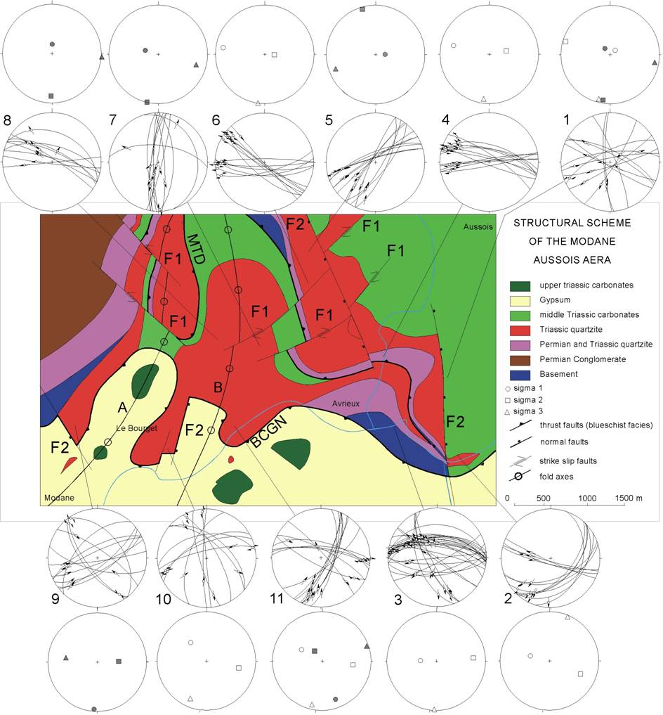
The Modane-Aussois area is located in the Briançonnais zone at the southern end of the South Vanoise basement dome (Figure 2). The Briançonnais series contain micaschists, conglomerates, quartzites and carbonates (Figure 3). Micaschists and Carbonate have recorded a polyphased tectonic history in where both early blueschist and late greenschist structures can be distinguished. However, within the quartzites, sedimentary structures are still well preserved and schistosities are not well developed unless locally in shear zones or tight folds.
Figure 3. Structural scheme of the Modane Aussois area

Structural scheme of the Modane Aussois area. A and B fold axes (see text for detail), MTD : Main Thrust Duplicate and BCGN : Basal Contact of the Gypsum Nape. Strereoplots and plot of the calculated stress axis has been added. Blank symbols: F1 tectonic event, Grey symbols: F2 tectonic event.
The first tectonic event is associated with nappe emplacement, formation of a first schistosity and folds into the carbonates and the micaschists. Tectonic contacts related to this event are the basal contact of the gypsum nappe and a major thrust duplicating the underlying series (Figure 3). Afterwards, initial planes, bedding schistosity and thrust contacts have been folded. At the map scale recent 3D modelling (Strzerzynski et al., 2005) have permitted the visualisation of two main folds: the first one is an open anticline with a fold axis oriented N-S and dipping towards the south (Figure 3A) and the second one is a pinched syncline with a fold axis oriented N30 and dipping also towards the south. The dip of the axes suggests that the folds were tilted by 20° towards the south after their formation, together with the whole part of the studied area. This southward tilting is responsible of the location of the structuraly higher units (the Schistes Lustrés) on the southern flank of the Maurienne valley at lower altitude than the Briançonnais units (Figure 2).
All rocks are affected by brittle faults. They bear slickensides that allow determining the slip direction. Depending on the siliceous or carbonate composition of rocks, quartz or calcite crystallizes on the faults plane. Accessory minerals are also present: chlorite, or various oxides. The brittle deformation at the outcrop scale has been studied in eleven stations (Figure 3). For each station, the orientation of the fault planes, striae and the slip-senses have been measured for 10 to 35 micro faults. Relative chronology between faults has also been observed. Fault plane azimuth is highly variable and most dips are greater than 60°. Slips are mainly strike-slip while normal and reverse movements are scarce (Figure 3).
In order to estimate the paleostresses that led to fault formation, a direct inversion method (Angelier, 1990) has been applied to each fault dataset using the TectonicFP software (Ortner et al., 2002). For eight stations, the whole dataset can be explained by a single state of stress, while for the three others, two states of stress are necessary to explain the whole dataset (Table1, Figure 1) 3). All computed states of stress (table1) are characterized by a horizontal orientation of the minimum axis 3 and values of the ratio ranging from 0.01 to 0.7. However, most of the ratio lower than 0.2 have been calculated using only conjugate faults and are thus not significant (Angelier, 1990). All significant ratios are thus comprised between 0.20 and 0.6 implying triaxial stress ellipsoids. On the basis of 3 orientation, two groups of stress state can be distinguished. The first one is characterized by 3 trending around N-S, while the second one is characterized by 3 trending around E-W (table 1, Figure 1) 3). In the field, faults associated with the 3 oriented E-W systematically cross-cut those associated with a 3 oriented N-S. We propose that the two states of stress affecting the Modane-Aussois area are the expression of two successive tectonic phases that we will later call F1 and F2, respectively (Figure 3).
The Contamines quarry is located near Lanslebourg in the upper part of the Maurienne valley (Figure 2). It is carved in silt, sand and gravel layers that have been interpreted as a recent lacustrine to fluviatille deposit system (Figure 5). These layers are covered by a 3 m thick deposit composed of angular blocs of rocks from the Schistes Lustrés units. Those deposits have been interpreted as a moraine (Fudral et al., 1994) indicating that a glacier may have covered the lacustrine to fluviatille layers. The age of the deposits depend closely of the age of the moraine deposit: it is possibly related to the Riss or the Wurm deglaciation periods (Fudral et al., 1994). Independently of the precise age of the morainic sediments, the Contamine quarry rocks are deposited during the last 80000 years and then are recording very recent stress states regarding to the alpine tectonic history. Faulting affects both the lacustrine to fluviatile and the moraine deposits indicating that it post-dates deposition and are not related to sedimentary processes (Figure 4). The position of the Contamines quarry at the bottom of a valley side might be favourable to slope movement related deformation. Moreover, some landslides are described downstream (Giraud, 1994) and upstream (Fudral, 1998) along the Maurienne Valley. However, there is no evidence of any slope movements near and over the Contamines quarry. As the formation of faults is not related to sedimentary process nor slope movements, we interpret them as tectonic features created by recent(s) crustal stress state(s).
Figure 4. F1 and F2 related stress axes plotted on stereodiagram
F1 and F2 related stress axes plotted on stereodiagram. Red circles: σ1, empty squares: σ2, blue triangles: σ3
Figure 5. General view of the Contamines quarry
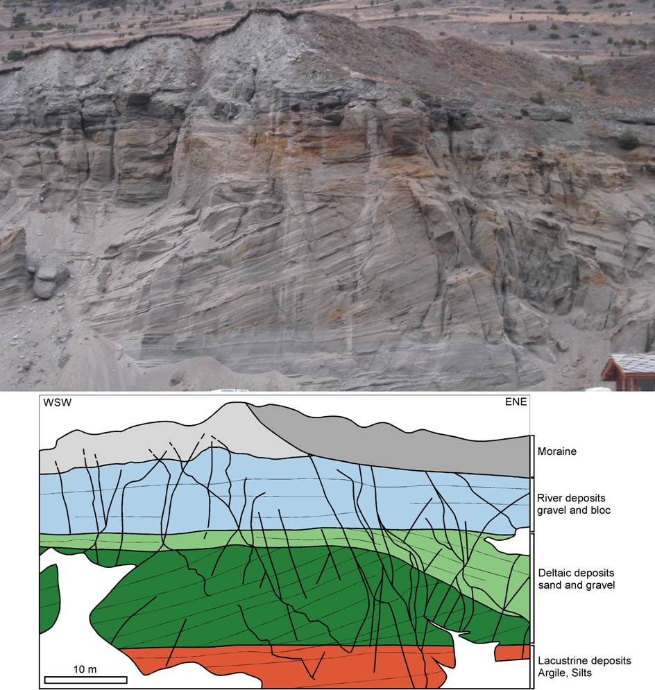
General view of the Contamines quarry. Botton to top succession of lake, deltaic and river deposits is coeval with the filling of an ombilic lake formed during climatic warming (Fudral et al., 1994). The moraine located on the top of the outcrop is related to a late glaciation event.
40 faults have been observed and measured at the bottom of the quarry wall (Figure 5). The fault planes are underlined by a 5 mm thick silt level that is preferentially preserved from erosion. Unfortunately, no striae are preserved along those fault planes, and thus the slip directions can not be constrained nor the true offsets measured. However, we have observed the apparent vertical offsets along the faults at the bottom of the quarry wall where the bedding is horizontal (Figure 4).
The main geometrical properties of the Contamines quarry’s faults are summarized below (Figure 5a):
- Azimuths of the 40 faults are all comprised between N100 and N170. Dips are directed to the SW or the SE.
- Dip values are between 30° and 90° and more than 80% of the dips are greater than 60°.
- Apparent movements are mainly normal. Inverse apparent movements are limited to faults steeply dipping (i.e. more than 70°) to the west.
On the basis of their dips, we have distinguished two faults groups: the first one is composed by the faults which have a dip value lower than 70° and second group contains the faults that have a dip greater than 70°. The first group (Figure 6b) is composed by 12 faults that show exclusively normal apparent movements. The azimuth of the faults does not vary by more than 10° around N150. Faults planes plunge to the NE and to the SW. The azimuth, the dip direction and the apparent movement of faults are all compatible with a set of conjugate normal faults formed during vertical shortening with a ~N60 direction of extension (Figure 5b). The second group is composed of 26 faults (Figure 5c). The azimuth of faults shows to distinct populations: between N160 and N170 with dips either to the E or W and between N110 and N140 with dips either to the NE or SW (Figure 5c). All faults dipping to the east show apparent normal offsets while all dipping to the west show apparent inverse offsets. The high dip value of the fault, the two azimuth populations and the association of reverse and normal apparent movement is compatible with a strike slip conjugate faults pattern in which faults of N160 to N170 azimuths are possibly left-lateral faults and faults of N110 to N140 azimuths are possibly right-lateral faults. Such a fault pattern is compatible with a N150 direction of shortening and a N60 direction of extension (Figure 5c). In absence of relative chronology evidence between the fault populations, we conclude that vertical and N150 shortening direction occur simultaneously in a context of N60 direction of extension. This stress-state, which occurred probably after 80000 yr. ago, is broadly compatible with that deduced from the regional focal mechanisms (Fig. 2: Delacou et al., 2004). It is also compatible with the N80 direction of extension of the F2 tectonic phase observed in the Modane area (Figure 3). This suggests that the present-day field stress is active since several thousands years and has produced micro-brittle faults now observable in Quaternary deposits as well as older consolidated rocks.
Figure 6. Fault planes of the Contamines quarry
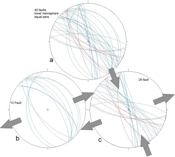
Fault planes of the Contamines quarry displayed on stereoplots. a) whole dataset, b) faults of plunge lower than 70° and c) fault of plunge greater than 70°. In blue : apparent normal faults, in red : apparent reverse faults.
We conclude that, after metamorphism and southward tilting of the nappe pile south of the South Vanoise dome, two stress-states have affected the Modane-Aussois-Lanslebourg area. The first one was characterized by ~N-S direction of extension while the second one characterized by ~E-W direction of extension is still active today.