1 Introduction to Sikkim-Darjiling
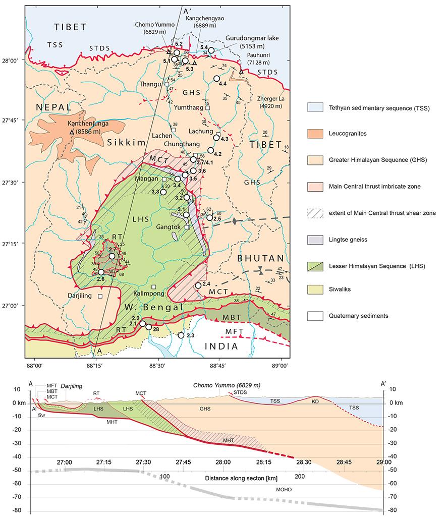
Sikkim is a small state of India situated between Nepal and Bhutan to the west and east, and Tibetan China and West Bengal to the north and south, respectively. A walk from Darjiling north through Sikkim to Thanggu and onto the Tibetan plateau follows ancient trade routes, as well as the earliest British expeditions to summit Everest, which required that the mountaineers travelled north from Darjiling up the Tista river valley to its headwaters before turning west to approach Everest via the Tibetan plateau. Figure 1.1 illustrates the geology and structures of the region based upon our recent mapping.
Figure 1.1. Geological map of Sikkim and Darjeeling Himalaya

Geological map of Sikkim and Darjeeling Himalaya. Compiled from: Gansser, (1983), Bhattacharyya and Mitra (2009), Long et al. (2011b), Kellett et al. (2013), Mottram et al. (2014). All stop locations for the field guide are indicated. STDS-South Tibetan detachment system, MCT-Main Central thrust, RT-Ramgarh thrust, MBT-Main Boundary thrust, MFT-Main Frontal thrust
Although heavily vegetated, Sikkim is transected by several roads, providing abundant access to road cuts in both NS and EW transects, particularly in the southern half of the region, from the foreland basin in West Bengal north over the Main Frontal thrust and into the Tista river valley and its many tributaries (Fig. 1.1). In this guide, we present some of the key outcrop and field views that illustrate the geology and particularly the structures of the region. The transect be gins at the southern orogenic front and travels north across the youngest structures of the Himalayan wedge, including neotectonic features and the Main Boundary thrust (Section 2). Above the Main Boundary thrust, the Lesser Himalayan sequence is stacked into a tight duplex, exposed along the Rangit River in the “Rangit window”. The guide then works northwards, visiting outcrops within the high strain zone of the MCT (Section 3). The Greater Himalayan sequence, sitting in the hanging wall of the MCT, is described in Section 4. The guide finishes in the north with one of the oldest structures of the Sikkim-Darjiling Himalaya, the STDS (Section 5). For introduction to the geology of the Himalaya particular to the Sikkim-Darjiling region beyond those at the beginning of each section, see Mukul (2000; 2010), Kellett et al. (2013), and Mottram et al. (2014).
Elevation in this map region ranges from near sea level within West Bengal to the top of Kangchenjunga, the world’s third highest peak at 8586 m, and the many roadways climbing through its hills permit relatively quick travel from low, humid, leech-friendly valley floors (worst leech infested areas are around 1500-3000 m in elevation!) to cold, high altitude, exposed regions. Those who have worked or travelled in drier Himalayan regions such as central Nepal may notice that Sikkim is a wet climate (Bookhagen and Burbank, 2010). As Sikkim remains a seismically active region, the several dams and exposed roadway leave the region vulnerable to earthquakes such as the magnitude 6.9 earthquake on 18 September, 2011, ~ 68 km NW of Sikkim’s capital Gangtok.