2 Frontal Darjiling-Sikkim Himalayan wedge
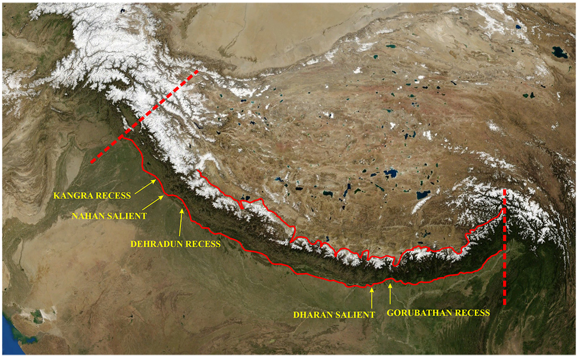
The Indian plate collided with the Eurasian plate along a large-scale (1000s of km), frontal, arc- shaped Himalayan boundary (Bendick and Bilham, 2001; Macedo and Marshak, 1999; Marshak, 2004). However, smaller scale sinuosity (100s of km) of the Himalayan mountain belt exists both in the Himalayan front as well as its hinterland (Fig 2.1). The sinuosity of the Himalayan front has been traditionally recognized in the western Himalaya as salients and recesses (e.g. Dehradun recess/re-entrant, Nahan salient and Kangra recess/re-entrant) (e.g. Powers et al., 1998) (Fig 2.1) and more recently, in the eastern Himalaya as well (e.g. Dharan salient, Gorubathan recess; Mukul, 2010) (Fig 2.1). The salient-recess transitions are typically recognized to be lateral or oblique ramps (Dubey et al., 2001; Yin, 2006) on the Main Himalayan thrust or tear faults (Mukul, 2010; Sahoo et al., 2000). Himalayan salients, recesses and associated transitional structures have impact on the variation of the deformation kinematics along the length of the Himalayan arc over space and time.
Figure 2.1. The Himalayan Arc
The Himalayan arc has a sinuous front at 100s km scale even though it has been recognized as a perfect arc at larger scales (Bendick and Bilham, 2001). The sinuosity is reflected in the formation of salients and recesses that are separated by transition zo nes such as active transverse tear faults. Sinuosity exists in the mountain front as well as in the hinterland as evident in the figure (Landsat-7 Image from http://himalayamountains.com)
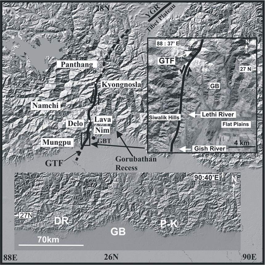
The Darjiling-Sikkim Himalaya spills over a salient-recess pair; the Gorubathan recess and the Dharan salient (Mukul, 2010; Fig 2.2). The salient-recess transition is characterized by a sinistral tear fault named the Gish Transverse Fault (GTF).
Figure 2.2. Digital Elevation Model of the Darjiling-Sikkim Himalayas
SRTM (Shuttle Radar Topography Mission) 90 m based DEM (Digital Elevation Model) of the Darjiling-Sikkim Himalayas showing the Gorubathan (GB) recess, the surface trace of the Gish Transverse Fault (GTF), the Tibet plateau and the Yadong-Gulu Rift (YGR) (from Mukul, 2010). The GTF has a prominent geomorphic expression in the frontal part of the area (right inset) and separates low Siwalik Hills on the west from flat cultivated plains to the east. The GTF has developed in the transition zone between the Dharan salient (DR) and the Gorubathan recess (GB). The Gorubathan recess is located between Dharan salient and the Phuntsoling-Kalikhola (P-K) salient in Bhutan (bottom inset)
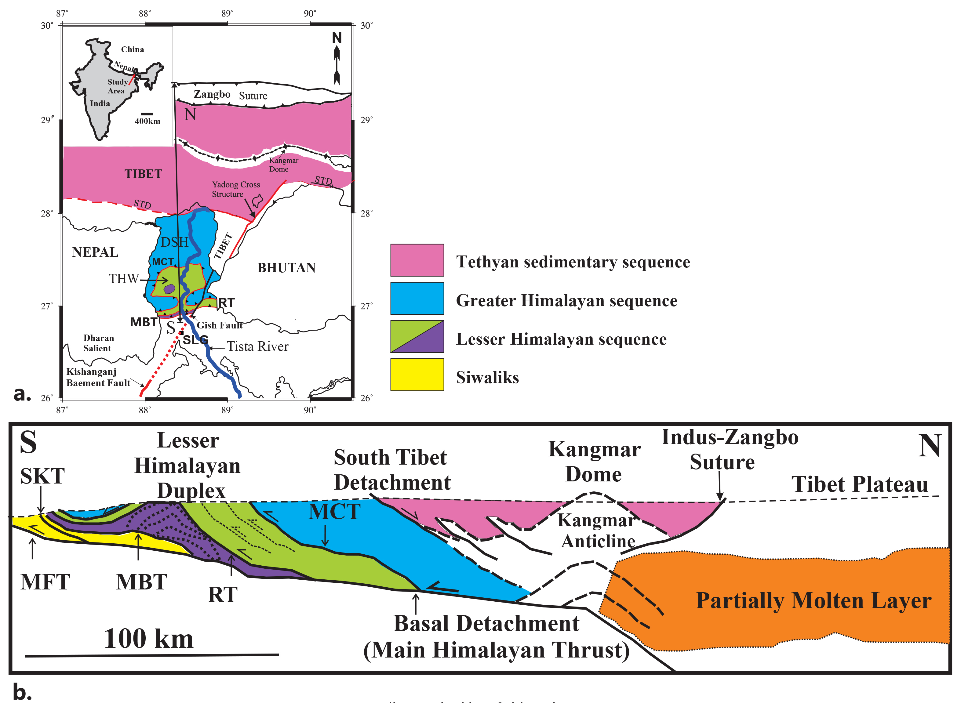
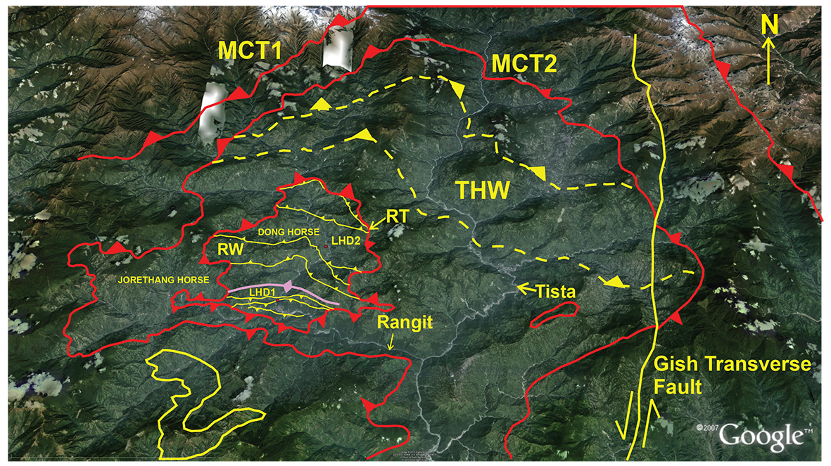
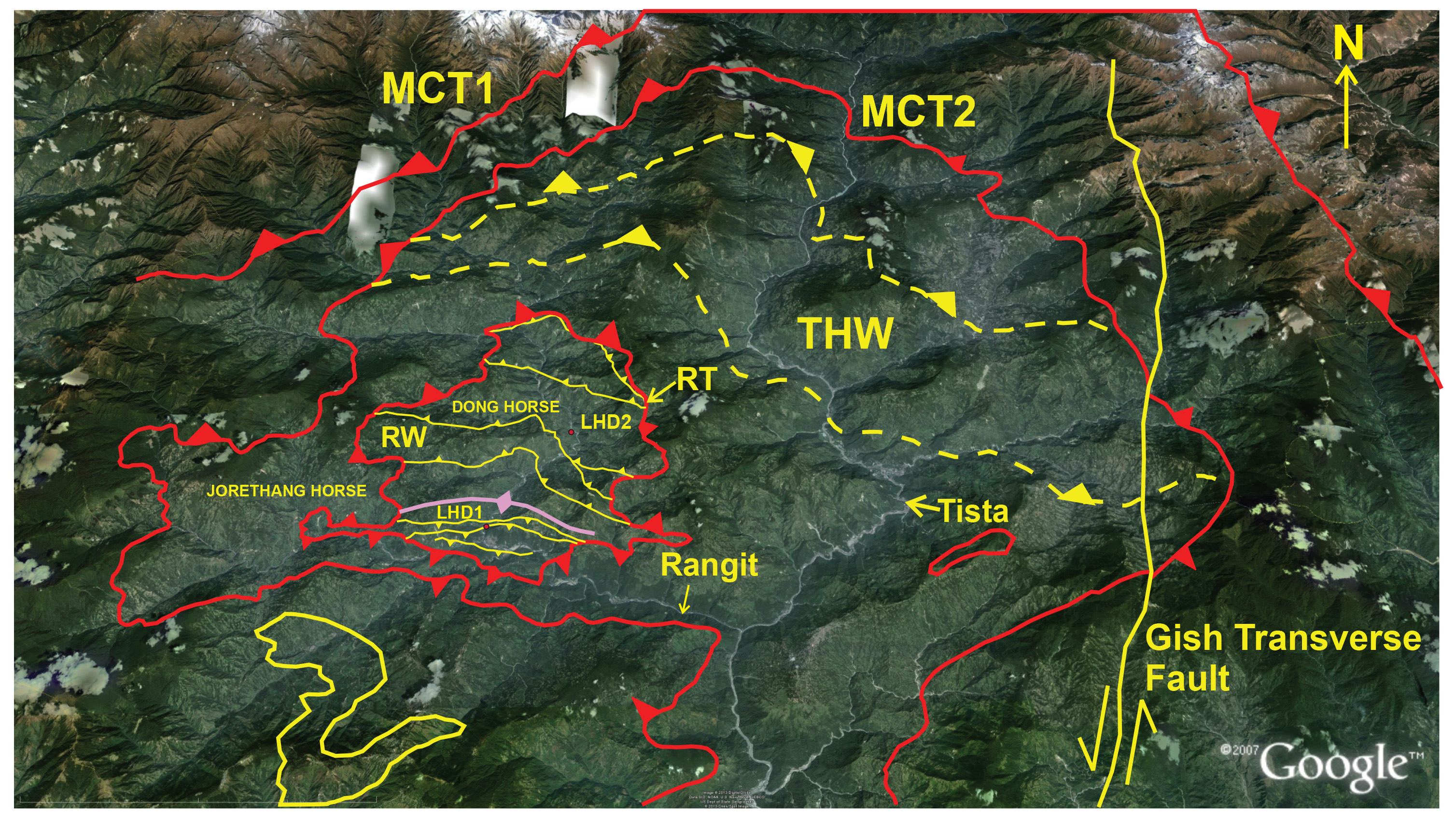
The geometry of the Himalayan orogen is wedge-shaped (Fig 2.3); the base of this wedge is defined by a north-dipping decollement named the Main Himalayan thrust (MHT) (Schelling and Arita, 1991; Nelson et al., 1996). Several east-west trending and south-vergent shear zones and thrust faults such as the Main Central thrust (MCT), Ramgarh thrust (RT) and Main Boundary thrust (MBT) sole with the MHT (Srivastava and Mitra, 1994; Nelson et al., 1996); the near- surface expression of the MHT is the MFT (Gansser, 1983; Lavé, and Avouac, 2001). The Himalayan wedge is defined as the region between the Indus-Tsangpo suture to the north and the Indo-Gangetic Himalayan foreland to the south. The Darjiling-S ikkim-Tibet (DaSiT) Himalayan wedge is characterized by two “dominant” structures that are most likely to have built taper in the wedge and driven the wedge forward into the foreland. The Darjiling-S ikkim Himalaya are characterized by the Lesser Himalayan duplex (LHD) (Fig 2.3) that has been recognized as a prominent structure involving the Daling, Buxa and the Gondwana units through much of the Lesser Himalaya (Bhattacharyya and Mitra, 2009; Mitra et al., 2010; Mukul, 2010). The Daling horses related to the LHD are exposed in the Tista Half window (THW) (Fig 2.3) and the Gondwana horses are exposed in the Rangit Window. The roof thrust of the former is the MCT while the roof thrust of the latter is the Ramgarh thrust; the basal thrust being the MHT-MFT.
Figure 2.3. The Darjiling-S ikkim-Tibet Himalayan wedge

Plan and sectional view of the Darjiling-S ikkim-Tibet Himalayan wedge. DSH- Darjiling-Sikkim Himalaya; SKT-South Kalijhora Thrust; MCT-Main Central Thrust; RT- Ramgarh Thrust; MBT-Main Boundary Thrust; MFT-Main Frontal Thrust; THW-Tista Half Window; STD-South Tibet Detachment; SLG-Siliguri
2.1 Seismicity in the Darjiling-Sikkim Himalaya
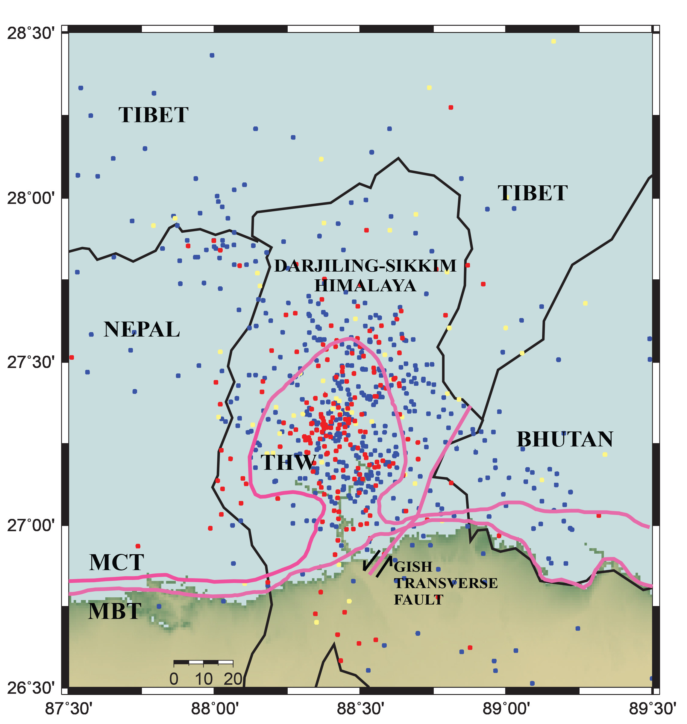
The seismicity patterns in the Himalaya have been well established for decades (Ni and Barazangi, 1984) wherein the bulk of the Himalaya (with the exception of Darjiling-Sikkim and Bhutan Himalaya) has been dominated by thrust earthquakes. Typically, the clustering of epicentres has been recognized to occur between the surface traces of the MCT and the MBT and have been typically attributed to activity along MHT (Pandey et al., 1999). However, great earthquakes have not been recorded in the recent or historic past from the Darjiling-S ikkim and Bhutan Himalaya. Given this, it has been postulated that a great earthquake of magnitude > 7 is practically imminent in the region (Bilham et al., 2001). The observed seismicity in the DSH is dominated by frequent moderate earthquakes. The strongest concentration of epicentres was found to occur between the surface traces of the MBT and MCT between the latitudes 27 º N and 27.5ºN indicating that the Tista half-window records majority of the earthquakes in the area (Pandey et al., 1999; De and Kayal, 2004; Mishra et al., 2010; Kumar et al., 2012) (Fig 2.4). In contrast, eastern Nepal records moderate and microearthquakes along the entire length of the Himalayan wedge (Pandey et al., 1999, de la Torre et al., 2007).
Figure 2.4. Seismicity in the Darjiling-S ikkim Himalaya

Distribution of seismicity in the Darjiling-S ikkim Himalaya (DSH) (after Mishra et al., 2010). Moderate earthquake distribution is shown as color coded circles (Red <3; Blue 3-4; Yellow >4). The micro-seismicity shows a concentration centered around the Lesser Himalayan Duplex (LHD) in the Tista Half Window (THW) which indicates that the LHD might be an active structure and causing the earthquakes
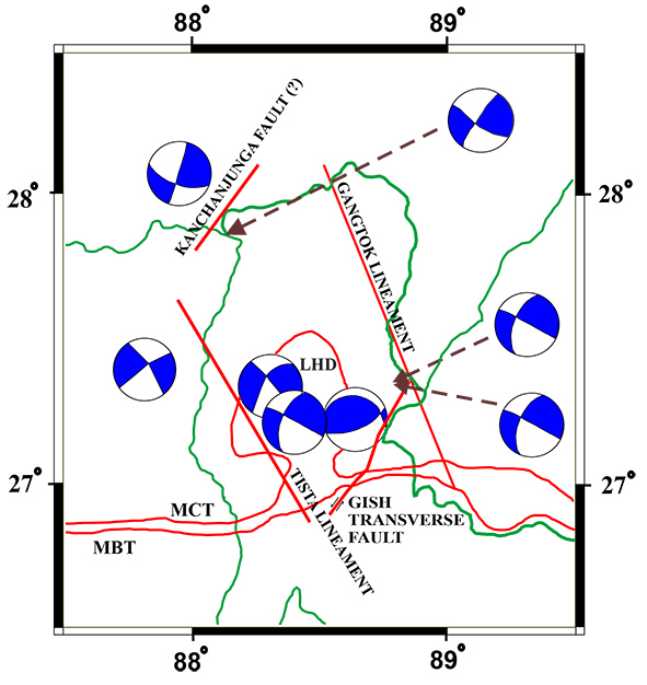
Focal mechanisms of the moderate earthquakes in the DSH indicate both thrust and strike-slip earthquakes (Fig 2.5). Prominent thrust earthquakes in the region include the 14 February, 2006 Sikkim earthquake of magnitude 5.3 (Mw) (Raju et al. 2007; Hazarika et al, 2010) as well as the 6.1 (Mw), 12 January, 1965 earthquake near eastern Nepal (Baranowski, 1984). However, moderate strike-slip earthquakes abound in the region (Ni and Barazangi, 1984; de la Torre et al., 2007; Raju et al., 2007). Significant strike-slip earthquakes include the November 19, 1980 Sikkim earthquake of Mb 6.2 (Ekstrom, 1987), February 12, 2001 of Mw 4.8, 20 May 2007, Mw 4.9 (de la Torre et al., 2007), and the 18 September, 2011 magnitude Mw 6.9 earthquake close to the Nepal–Sikkim border (Rajendran et al., 2011; Kayal et al., 2011; Kumar et al., 2012). This clearly indicates that both strike-slip and thrust seismotectonics are operational in the Darjiling- Sikkim and Bhutan Himalaya (e.g. Drukpa et al., 2006).
Figure 2.5. Focal mechanisms in the Darjiling-S ikkim Himalaya
Map showing the main focal mechanisms seen in the Darjiling-S ikkim Himalaya. Both moderate thrust and strike-slip earthquakes are seen in the DaSiT wedge which points to the fact that both thrusting and strike-slip faulting is active in the DSH
2.2 The Main Boundary thrust (MBT 1-N 26.92475˚, E 88.44895˚; MBT 2-N 26.92502˚, E 88.45403˚)
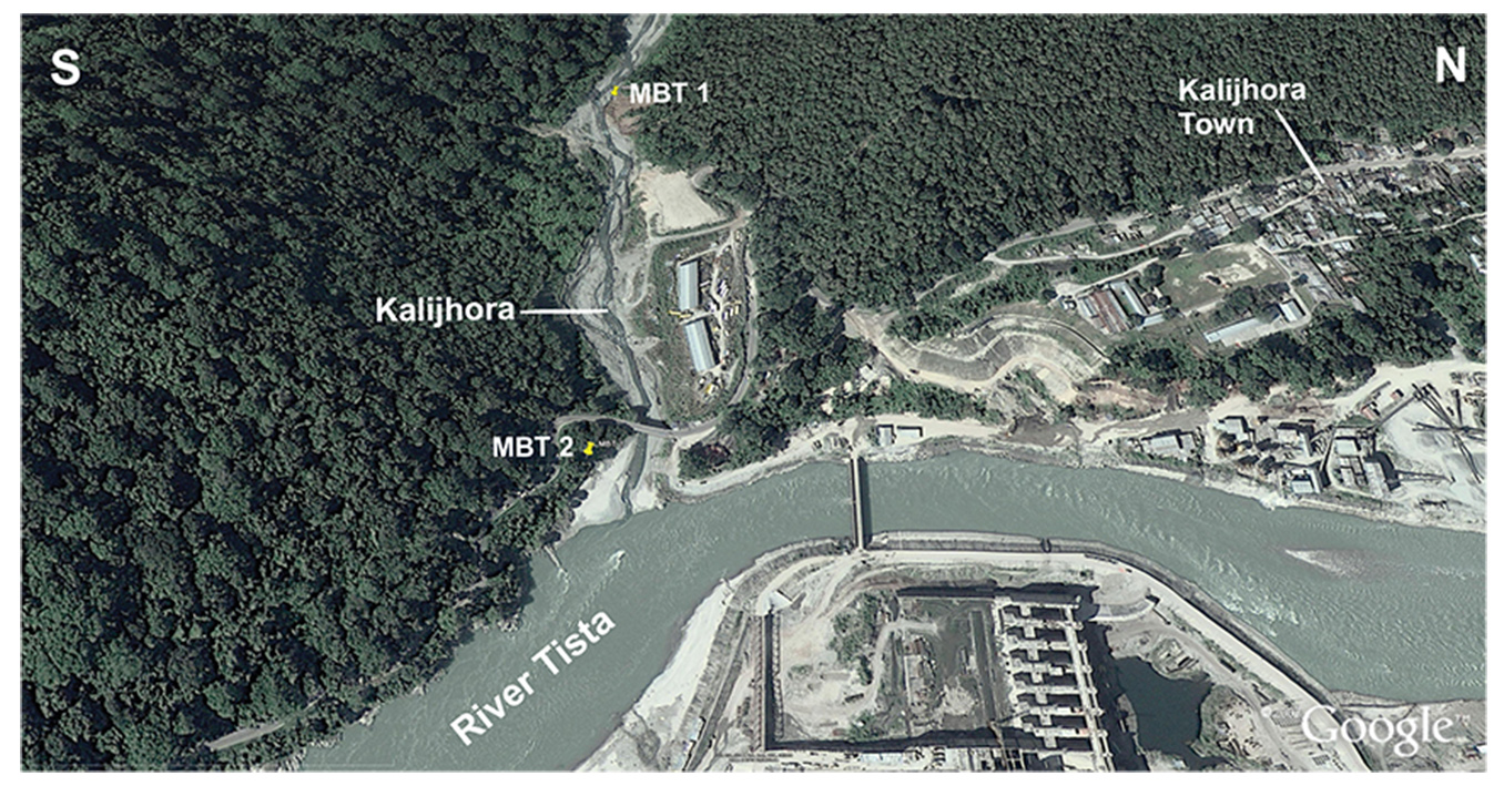
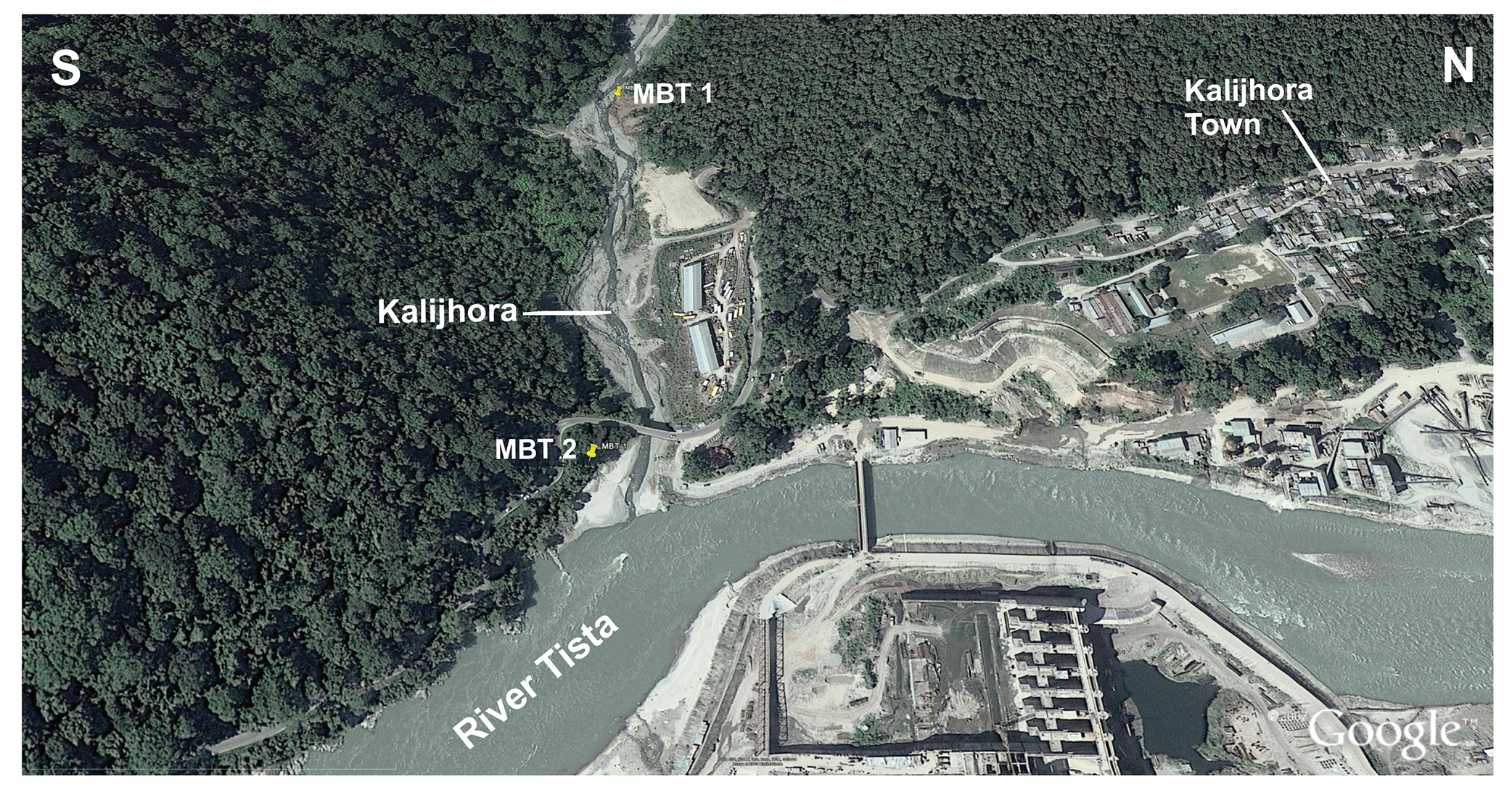
The Main Boundary thrust is best exposed in the Kalijhora village area of the Darjiling Himalaya (Fig. 1.1, Table 2.1). The rocks are exposed in the Kalijhora and Tista river sections. Some of the outcrops described below have been destroyed in the development activities in the area related to the construction of a dam on the River Tista on the MBT fault zone (Figure 2.6).
Figure 2.6. The location of Main Boundary Thrust Fault zone outcrops
Google Earth Imagery (tilted) showing the location of Main Boundary Thrust Fault zone outcrops near the join of Kalijhora with Tista. The view is oriented N-S with N at the right hand side of the image
Table 2.1. Virtual field trip stops for frontal Darjiling-Sikkim Himalaya wedge
| Locality | Lat (N) | Long (E) | Description | |
|---|---|---|---|---|
| 2.1 | MBT 1 | 26.92475° | 88.44895° | Main boundary thrust, upper Kalijhora river |
| 2.2 | MBT 2 | 26.92502° | 88.45403° | Main boundary thrust, lower Kalijhora river |
| 2.3 | GTF 1 | 26.87611° | 88.60288° | Gish river in Himalayan foreland |
| 2.4 | GTF 2 | 27.08429° | 88.66658° | Near Lava town, close to Indo-Bhutan border |
| 2.5 | GTF 3 | 27.36821° | 88.71383° | Near Nathu La, Indo-Tibetan border |
| 2.6 | LHD 1 | 27.13328° | 88.27953° | Tista half window, Jorethang horse |
| 2.7 | LHD 2 | 27.20002° | 88.32634° | Tista half window, Dong horse |
| 2.8 | S of Kalijhora village | ~26.9177° | ~88.4647° | 1 km south of Kalijhora village, on National Hwy 32A |
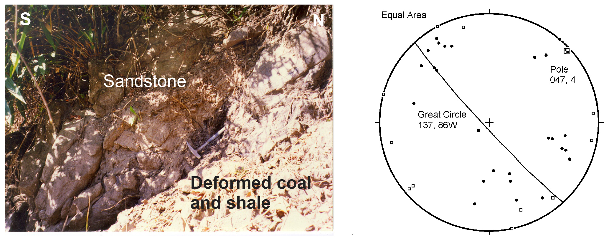
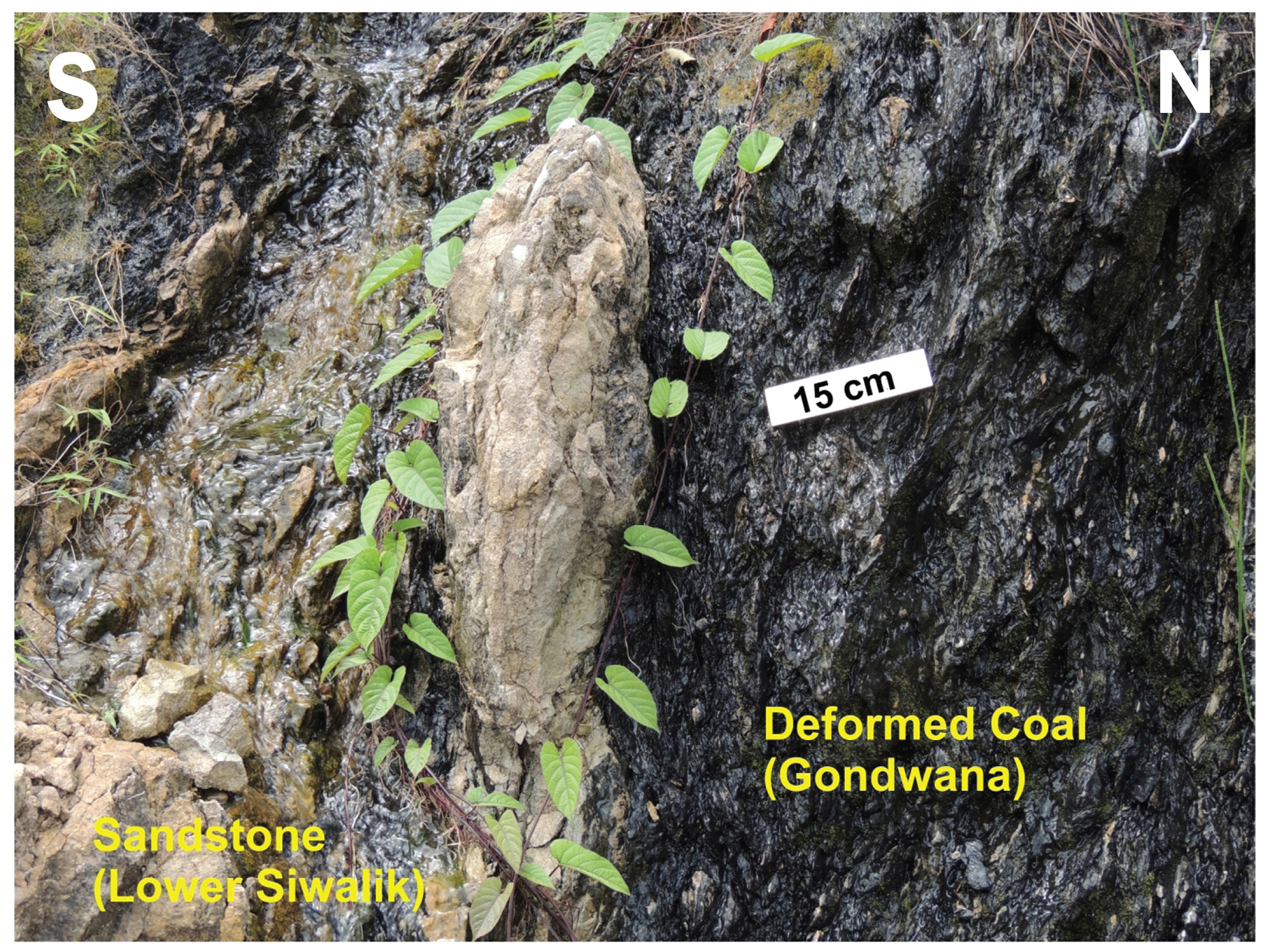
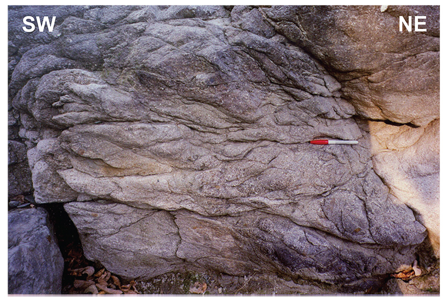
The Main Boundary thrust carries Gondwanan coarse-grained sandstone and shale over the Lower Siwalik fine-grained sandstones. The fault zone itself has been folded by younger thrusts (Mukul, 2000). At stop 2.1 (MBT 1) the fault zone is characterized by deformed coal and shale that dip to the north (Fig 2.7). Folding of the MBT fault zone is evident from change of dip of the fault zone from northerly to south-westerly as shown in Fig 2.8. Antiformal folding of the MBT fault zone and the hanging wall rocks around a north-easterly plunging fold axis is indicated by the stereoplot. The south dipping limb of the folded MBT fault zone is exposed at stop 2.2 (MBT 2). The exposure represents the inverted south-dipping limb of the folded MBT fault zone. The core of the MBT fault zone is well exposed here and characterized by deformed coal that has undergone flow in the core of the fault zone (Fig 2.9) around Lower Siwalik sandstone clasts in a "mixed" zone.
Figure 9. Main Boundary Thrust exposure at location MBT 1

Main Boundary Thrust exposure at location MBT 1. Equal area stereoplot of poles to predominantly NW dipping bedding (•) and cleavage () in the shale and sandstone of the Main Boundary Fault zone seen in Fig 2.6. Cleavage is observed to be sub-parallel to bedding in the fault zone
Figure 2.8. Evidence of folding of the Main Boundary Thrust fault

Main Boundary Thrust exposure at location MBT 1. Evidence of folding of the Main Boundary Thrust fault zone along with the hanging wall Gondwana sandstones. (a) The fault contact (seen by the location of the hammer) and the hanging wall Geabdat sandstones dip southerly in this photograph as opposed to their north-west dip seen in Figure 2.6. Equal area stereoplot of poles to bedding (•) and cleavage () in the hanging wall of the MBT in the Gondwana Geabdat sandstone along the northern bank of the Kalijhora section
Figure 2.9. Main Boundary thrust exposure at location MBT 2

The core of the MBT fault zone and the contact between the Gondwana deformed coal and Lower Siwalik sandstones is a "mixed" zone and seen in the picture above. The sandstone occurs as clasts in a matrix of fine - grained deformed coal that "flows" around the sandstone clasts. Sandstone clasts show brittle deformation and extensive fracturing
In the hanging wall, the Gondwana sandstone is brecciated (Fig 2.10) and the beds as well as the cleavage dip moderate to steeply to the south in hanging wall as well as footwall rocks indicating that the entire exposure of the MBT fault zone near MBT 2 is overturned (Fig 2.11). The folding of the MBT fault zone also suggests that the MBT is unlikely to be seismogenically active because a fault can only be folded when it has ceased to be active (Boyer and Elliott, 1 982). Therefore, the seismicity observed in Fig 2.4 is, in all probability, not related to the MBT in the Darjiling Himalaya.
Figure 2.10. Gondwana sandstone in the MBT fault zone
Exposure of the Gondwana sandstone in the MBT fault zone at location MBT 2. Fine-grained cemented breccia zone along the boundary of the MBT fault zone rocks and the hanging wall Geabdat sandstones observed along the southern bank of the Kalijhora stream section close to its junction with River Tista. The fault plane defined by the breccia is sub- parallel to the plane of the paper and the pen (scale) sits on it. The brecciated zone dips to the southeast indicating that the MBT fault zone is probably folded into an antiform-synform pair in which the synform is overturned
Figure 2.11. Equal area stereoplot of poles to beddingand cleavage

(a) Equal area stereoplot of poles to bedding (•) and cleavage () within the MBT fault zone near the junction of Kalijhora stream and Tista River (Location MBT 2). The cleavage and bedding within the fault zone dip south-easterly and are sub-parallel. (b) Equal area stereoplot of poles to bedding (•) and cleavage () in the hanging-wall Gondwana sandstones of the MBT fault zone. Both the bedding and the cleavage within the fault zone dip moderately to the southeast near the junction between Kalijhora stream and Tista River and are sub -parallel
2.3 The Gish Transverse fault (GTF 1-N 26.87611˚, E 88.60288˚; GTF 2-N 27.08429˚, E 88.66658˚; GTF-3 N 27.36821˚, E 88.71383˚)
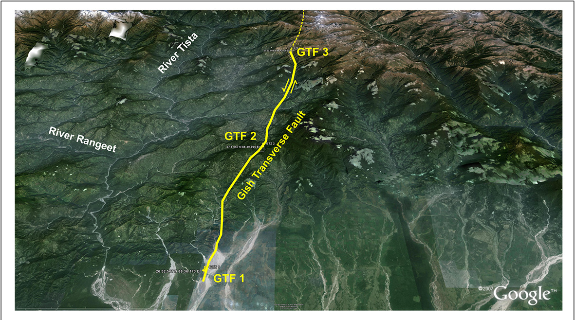
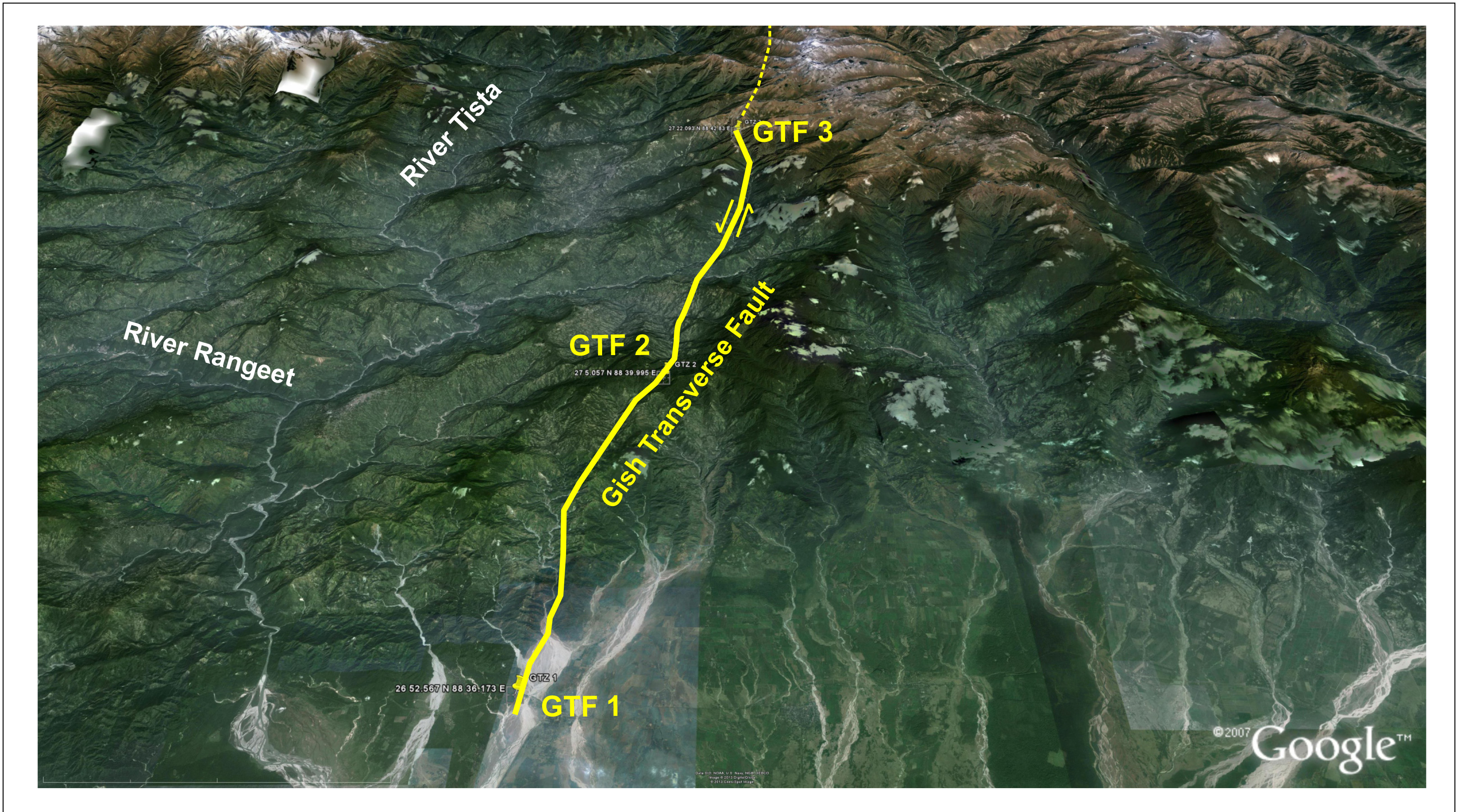
The Gish Transverse fault (GTF) is a transitional structure that has developed between the Gorubathan Recess and the Dharan salient (Fig 2.2). The GTF has been mapped from the Gish River exit in the foothills (stop 2.3, GTF 1) to the Indo-Tibetan border near Nathu La (stop 2.5, GTF 3) (Fig 2.12; Table 2.1). With an eastward step the fault continues in the western Bhutan as Lingshi fault (Gansser, 1983). The fault near the Gish River exit has a topographic expression and separates low Siwalik hills to the west from alluvial flat land characterized by Quaternary surfaces (Nakata, 1989) (Fig 2.13); Siwalik rocks have not been exposed at all in the Gorubathan recess.
Figure 2.12. The location of the Gish Transverse Fault
Google Earth Imagery (tilted) showing the location of the surface trace of the Gish Transverse Fault between the Himalayan foreland (GTF 1) and the Indo-Tibetan border (GTF 3) near Nathula Pass
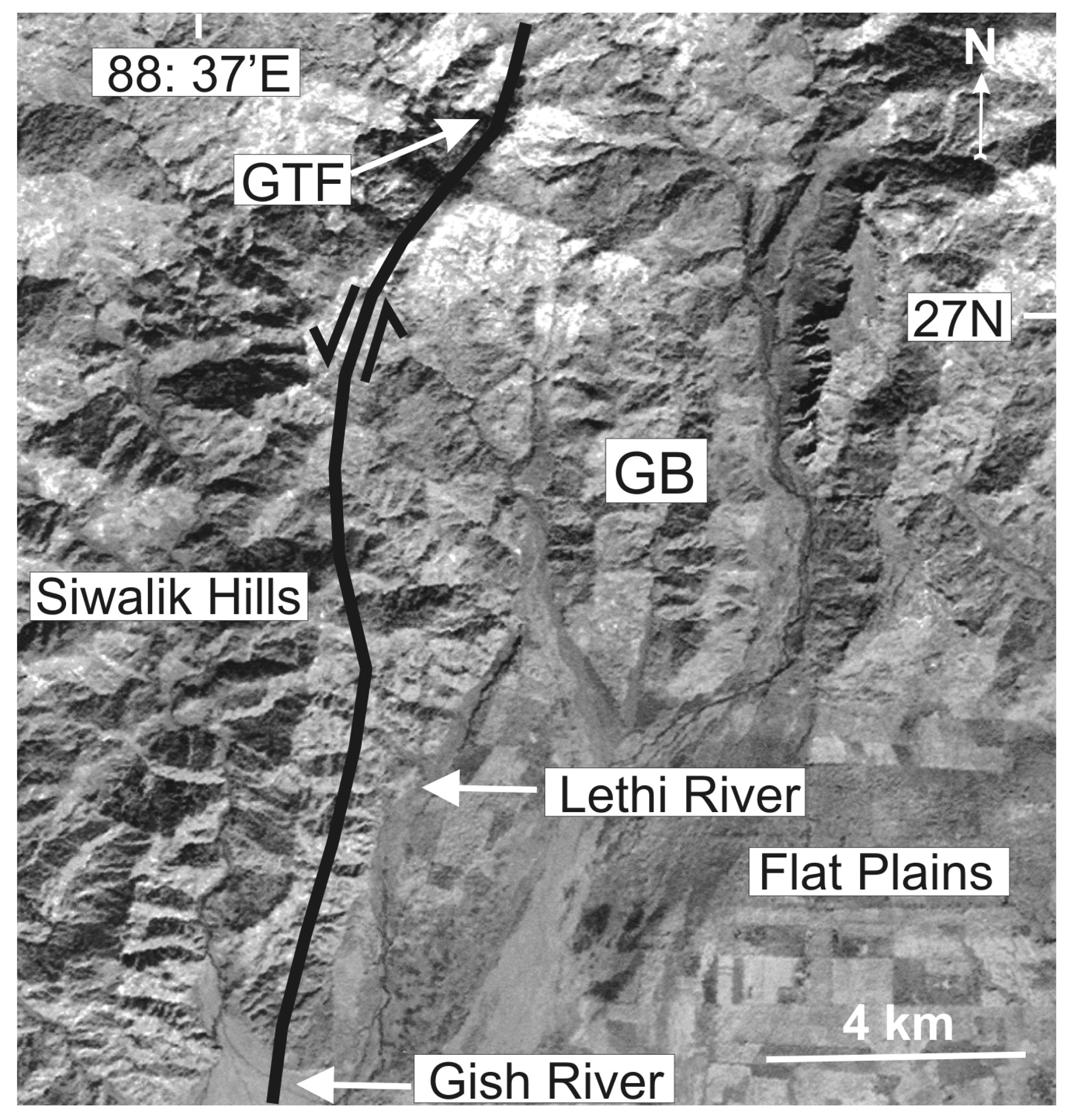
Figure 2.13. Surface trace of the GTF

Surface trace of the GTF near GTF 1 (Mukul, 2010). Siwalik Hills are separated from flat plains in the Gorubathan recess (GB) by the GTF in the satellite imagery of the foothills of the Darjiling Himalaya. Geomorphic expression of the GTF is best preserved in the foothills
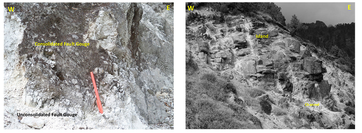
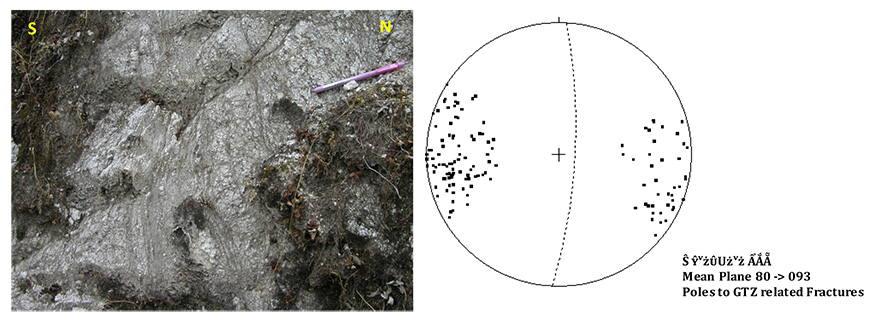
The core of the GTZ is characterized by fine-grained incohesive fault gouge, much of which has turned to soil. The fault zone is recognized by the presence of cemented fault gouge as well as island-channel structures. The islands consist of less deformed rocks and are surrounded by more deformed and grain-size reduced channels that swivel or flow around the islands (Newman and Mitra, 1994) (Fig 2.14). Brittle overprinting of earlier ductile structures such as schistosity is also seen (Fig 2.15a). These observations indicate that the GTZ is an elastico-frictional fault that was active in near-surface conditions. The GTZ fault and fault damage zone are characterized by widespread sub-vertical fracturing (Fig 2.15b) trending approximately N-S following the overall trend of the GTZ.
Figure 2.14. Fault gouge from the Gish Transverse Fault
(a) Consolidated and unconsolidated fault gouge from the Gish Transverse Fault near GTF 2. Consolidated gouge typically form islands within a groundmass of unconsolidated fine grained gouge near the center of the GTF fault zone. (b) Steeply-dipping bedding surrounded by fine-grained unconsolidated fault gouge describing an overall island-channel geometry near GTF 3
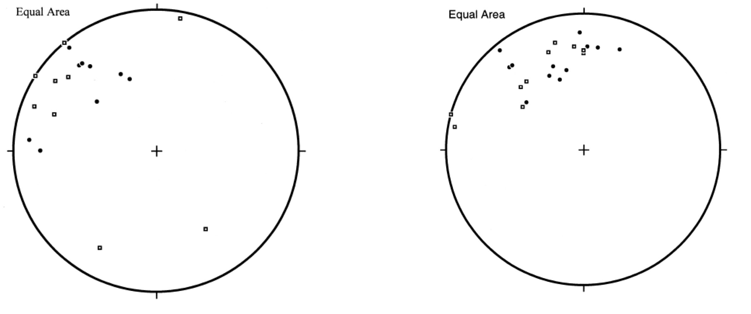
Figure 2.15. Relict schistosity and Equal area plot of pole to GTZ related fractures
(a) Relict schistosity is seen overprinted by brittle structures in gneiss in the GTF fault zone near GTF 3. (b) Equal area plot of pole to GTZ related fractures in the fault damage zone indicating that the GTF is a transverse, steep, east-dipping, sinistral fault
2.4 Lesser Himalayan duplex (LHD 1- N 27.13328˚, E 88.27953˚; LHD 2- N 27.20002˚, E 88.32634˚)
The Lesser Himalayan duplex (LHD) was first postulated from a balanced cross-section in the Kumaon-Garhwal Indian Himalaya below the present day level of erosion (Srivastava and Mitra, 1994). The LHD has been subsequently mapped at the present day level of erosion in Nepal (DeCelles et al., 1998), Bhutan (McQuarrie et al., 2008) and Sikkim (Bhattacharyya and Mitra, 2009; Mitra et al., 2010). The LHD is a hinterland-d ipping duplex in Kumaon-Garhwal, central Nepal as well as in Bhutan. In Sikkim, the LHD is a complex structure (Fig 2.16). The frontal horses of the structure are foreland-dipping, the middle horses form an antiformal stack, and the rear horses are hinterland-dipping (Bhattacharyya and Mitra, 2009; Mitra et al., 2010).
Figure 2.16. The Lesser Himalayan Duplex (a)
The Lesser Himalayan Duplex (LHD) in Sikkim as exposed in the Tista half window (THW) and Rangit Window (RW). The frontal horses of the LHD in the Rangit window dip to the south, the middle horses are folded into an antiformal stack and the rear horses dip to the north defining the most complex LHD geometry mapped in the Himalaya till date (Bhattacharyya and Mitra, 2009; Mitra et al., 2010)
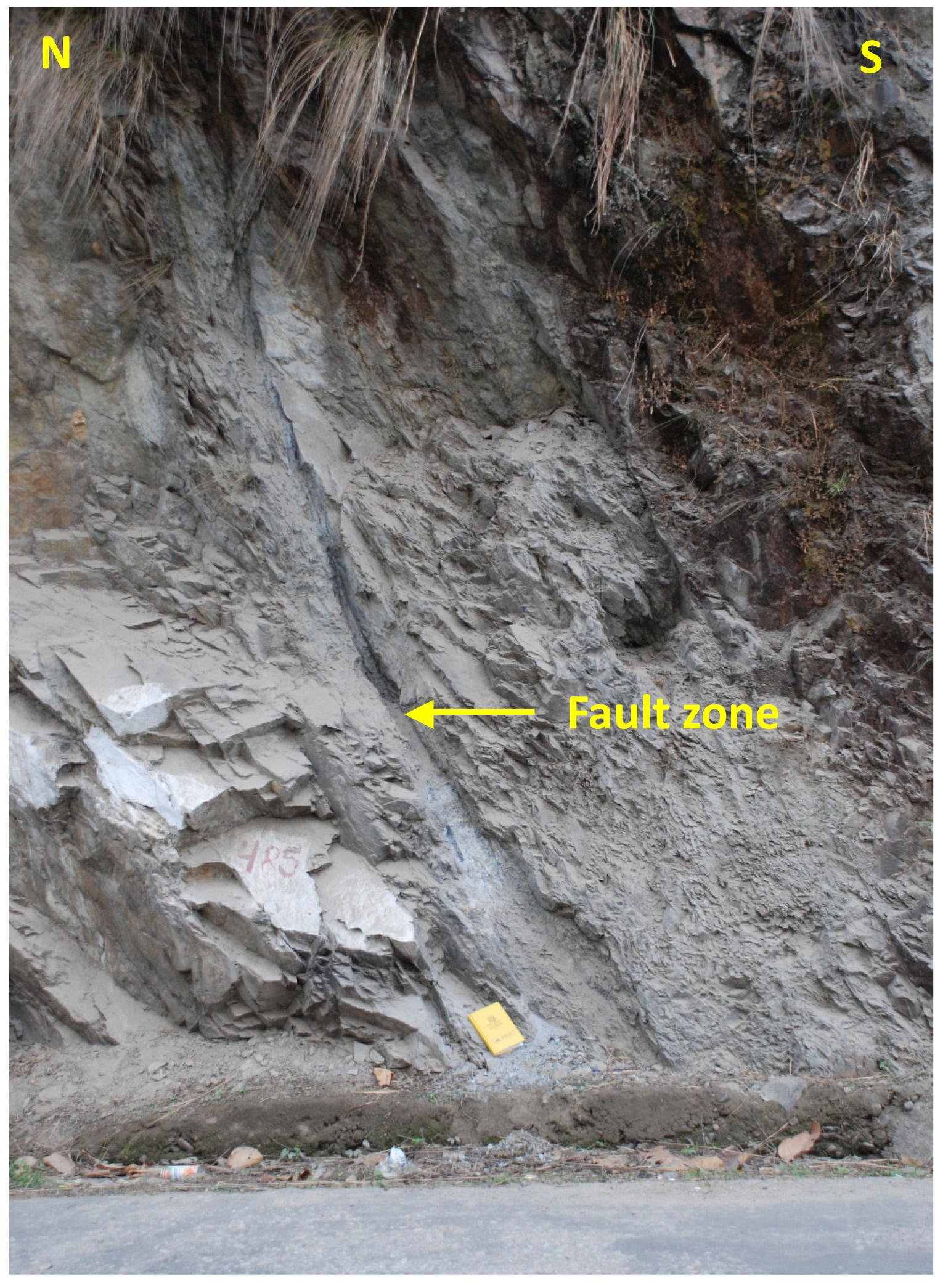
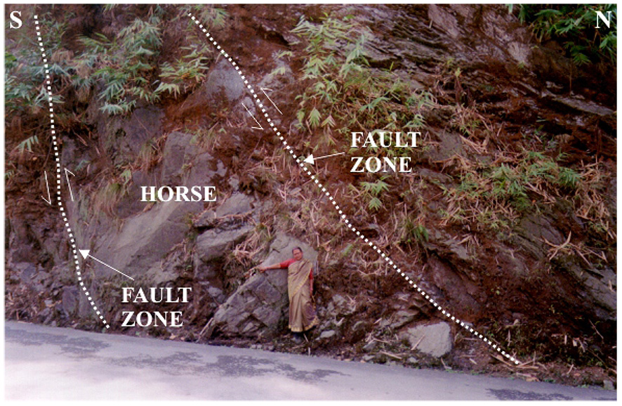
The large-scale geometry of the LHD is difficult to illustrate in a field guide. However, outcrop scale structures can be observed. A foreland-dipping horse (stop 2.6, LHD 1) can be observed in the Jorethang horse (Table 2.1). A sandstone-shale-coal Gondwana sequence is exposed here. The bedding dips steeply to the south and is near vertical (Fig. 2.17). The coal seams and shale have undergone brittle deformation and form centimetre- to metre-scale fault zones (Fig. 2.17). Farther north, the LHD contains horses that dip to the north, describing a hinterland-dipping duplex (stop 2.7, LHD 2). Outcrop-scale horses and fault zones are also seen within the large horses; these also dip to the north (Fig. 2.18) (Mukul, 2010). The LHD, in all probability, is an active structure in the Darjiling-S ikkim Himalaya (Figs. 2.4, 2.5) as very pronounced clusters of earthquake epicentres are located within the trace of the LHD. The LHD, kinematically, is a "dominant" structure that has driven the
Figure 2.17. The Lesser Himalayan Duplex (b)

The Lesser Himalayan Duplex (LHD) in Sikkim as exposed in the Tista half window (THW) and Rangit Window (RW) near LHD 1 in Fig 2.15. The frontal horses of the LHD in the Rangit window such as the Jorethang Horse dip to the south. Fault zones have developed in the coal and shale formations. (Matin and Mazumdar, 2009; Bhattacharyya and Mitra, 2009; Mitra et al., 2010)
Figure 2.18. The Lesser Himalayan Duplex (c)
The Lesser Himalayan Duplex (LHD) in Sikkim as exposed in the Tista half window (THW) and Rangit Window (RW). The frontal horses of the LHD in the Rangit window dip to the south, the middle horses are folded into an antiformal stack and the rear horses dip to the north defining the most complex LHD geometry mapped in the Himalaya till date (Bhattacharyya and Mitra, 2009; Mitra et al., 2010). A hinterland-dipping outcrop scale horse is seen in the figure near LHD 2 in Fig 2.15
2.5 Neotectonics in the frontal Darjiling-Sikkim Himalaya (~N 26.9177˚, ~E 88.4647˚)
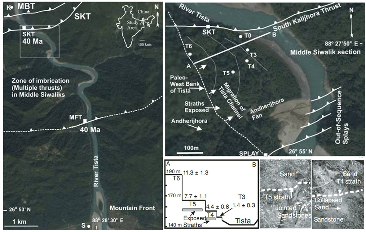
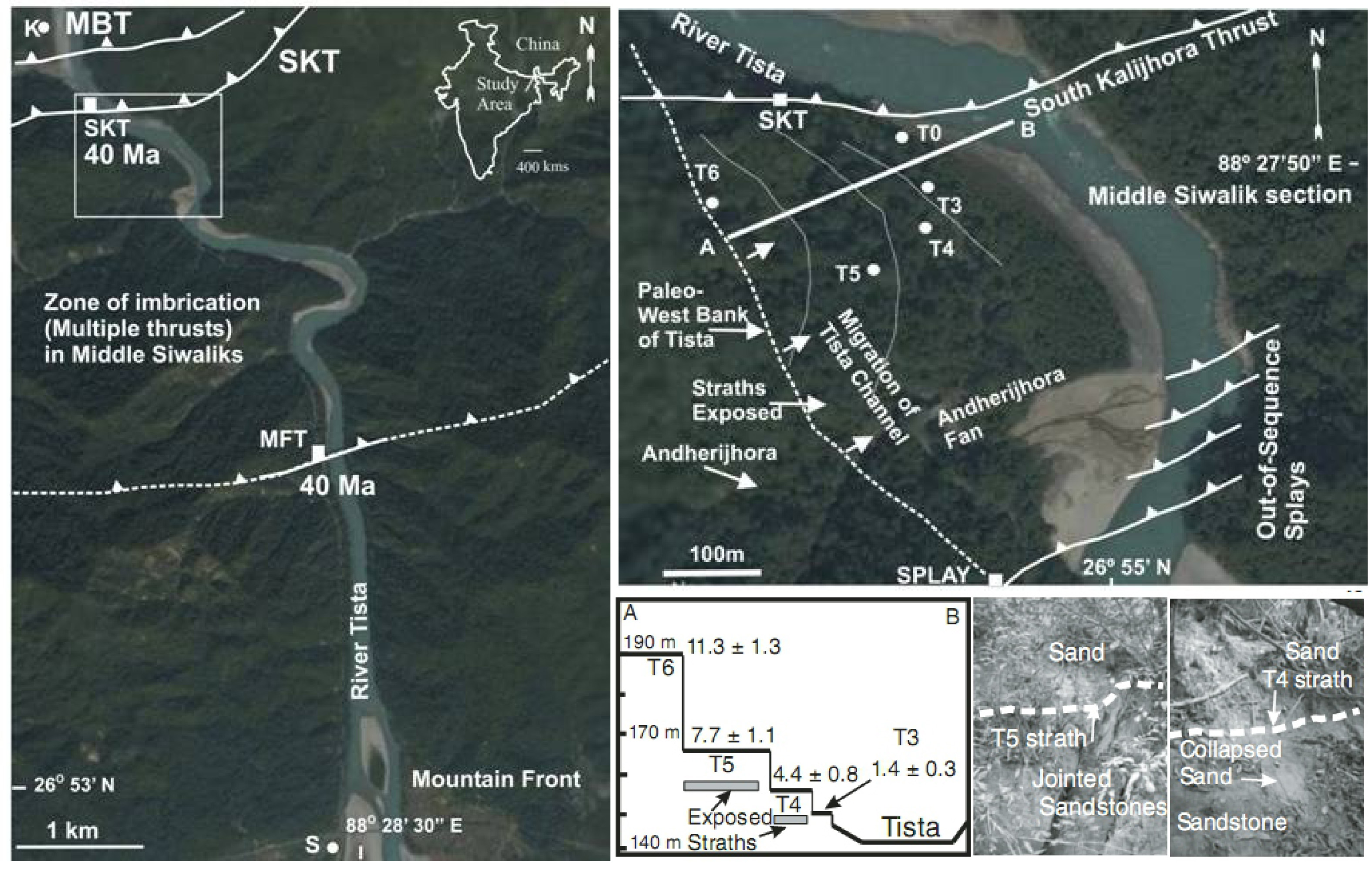
The Darjiling-Sikkim Himalaya is characterized by a frontal imbricate zone in the footwall of the MBT that repeats the Siwalik section multiple times (Mukul, 2000; Mukul et al., 2007; Kundu et al., 2011; 2012). Out-of-sequence thrusts are observed within this imbricate zone on surface- breaking faults north of the MFT in the Darjiling sub-Himalaya. The Tista River responded to this deformation by migrating 150 m eastward (average rate ~ 13 mm/ yr) and by incising 48 m vertically (average rate ~ 4.4 mm/ yr), creating unpaired, disjointed strath terraces between 11.3 – 1.3 ka and 1.4 – 0.3 ka (Mukul et al., 2007). The site of this out-of-sequence neotectonics is about 1 km south of Kalijhora village along the National Highway 32A in Darjiling-Himalaya (stop 2.8 of Table 2.1, Fig 2.19). Out-of sequence splays that display well-formed fault gouge are seen in the Tista river section (Fig 2.20); raised strath fluvial terraces are seen to the north and in the hanging wall of these splays. It is interpreted that these terraces are neotectonic in origin as they occur only in the immediate hanging-wall of the
Figure 2.19. Out-of-sequence deformation in the frontal Darjiling-S ikkim Himalaya
Out-of-sequence deformation in the frontal Darjiling-S ikkim Himalaya (Mukul et al., 2007). Sample locations of fault-zone gouge north (South Kalijhora thrust, SKT) and south (Main Frontal thrust, MFT) are shown by white squares. S-Sevak; K-Kalijhora; MBT-Main Boundary thrust. Out-of-sequence splays and Tista terraces (T3- T6). Straths are only exposed in the Andherijhora section, as shown on the imagery on the right (top). White circles indicate sample locations of terraces; white squares indicate fault-zone gouges. T0 is sample location of modern sand. Scaled section of terraces is shown in right (bottom) (along AB). Ages are given in ka. Field photographs show strath surfaces as seen in Andherijhora section
Out-of-sequence deformation has been postulated as a mechanism to build taper in a sub-critical Coulomb wedge (DeCelles and Mitra, 1995) which, therefore, suggests that the foreland fold- and-thrust belt of Darjiling-S ikkim Himalaya is deforming internally and building taper to attain criticality (Mukul et al., 2007).
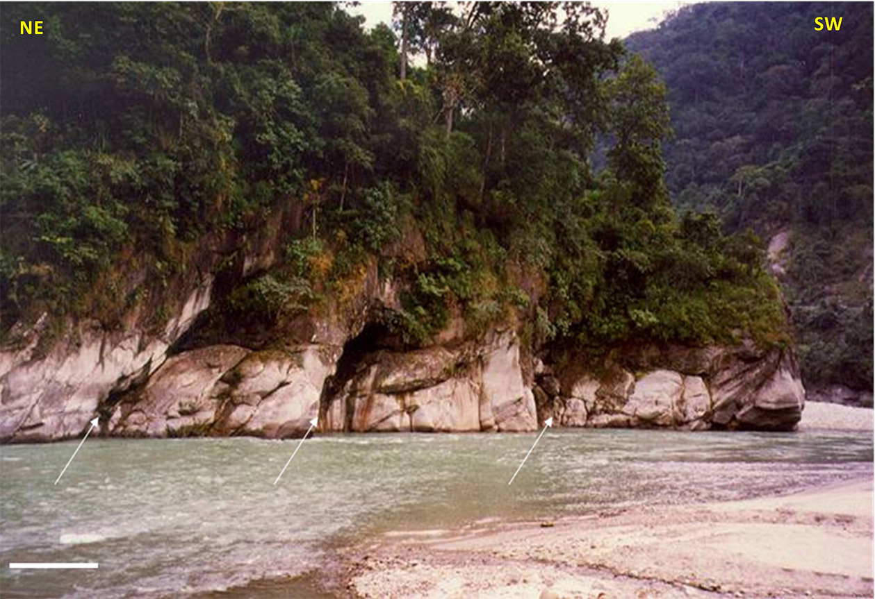
Figure 2.20. Out-of-sequence imbricate faults
Out-of-sequence imbricate faults (marked by arrows) that repeat Middle Siwalik (Tertiary) sandstone. Fault gouge from the southern-most imbricate was dated to be 20 ka. The fault zones have developed in the shale. The scale bar is 15 m