The NCC and its adjacent areas
The NCC crosses a thick portion of the GHS exposed in the central-eastern sector of the Himalayan chain (Figs. 1 and 2). A tectonic sketch map of the area between the Khimti Khola and the Dudh Khosi valleys, investigated during several field campaigns, is reported in Fig. 2. A selection of the most representative meso-structures and of the main rock-types cropping out in this area is reported in Figs. 3 and 4.
The general geologic setting of the area extending from the Khimti Khola to the west to the Dudh Kund Khola to the east (Fig. 2) has been described mainly by Ishida (1969), Maruo and Kizaki (1981) and Schelling (1992). Opposite to the relatively poor geological knowledge of the Khimti Khola and Dudh Kund area, the Dudh Kosi valley - immediately eastward of Dudh Kunda - has been the object of extensive geological studies since long time (e.g. Carosi et al. 1999; Searle et al., 2003 and therein reference), because it represents the principal trekking-route to the Everest region. To the west of the area shown in Fig. 2, recent papers (Larson, 2012; 2013; Larson and Kellett 2014- field guide submitted for this JVE volume) describe the geology of Tama Kosi region.
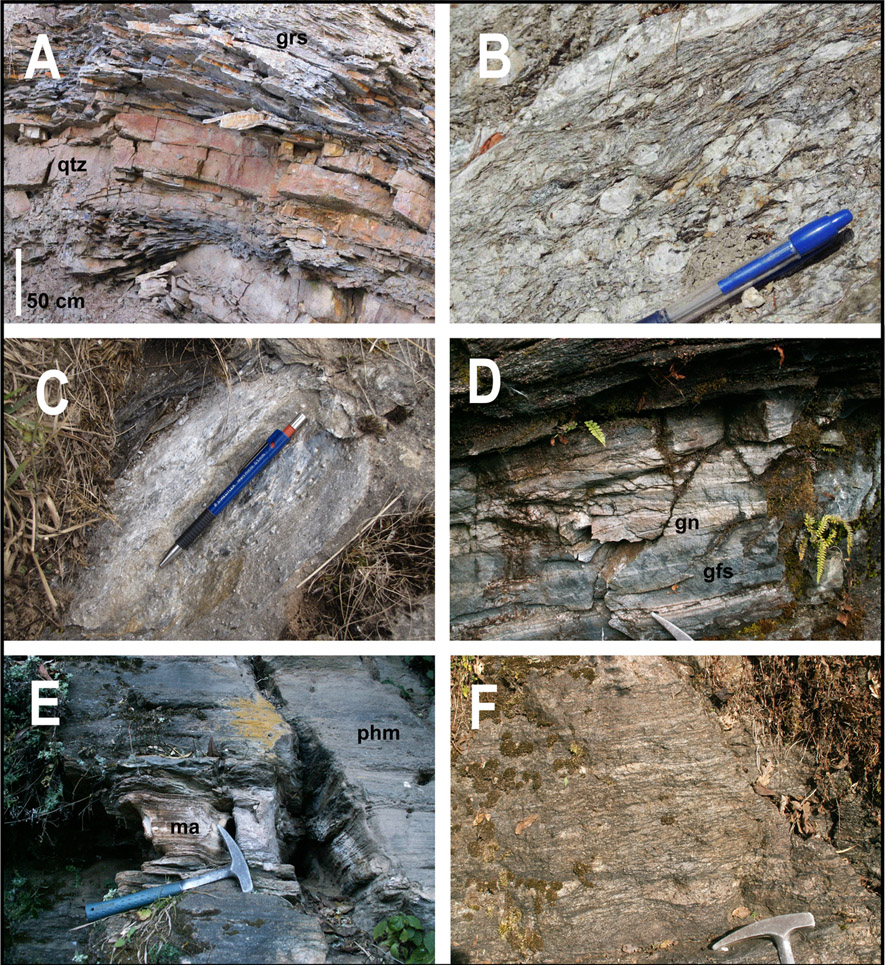
As shown in Fig. 2, the LHS is exposed in the south-eastern sectors of the considered area, along the Dudh Kosi and Dudh Kund Khola valleys, downstream of Kharikhola and Phaplu villages respectively (Fig. 2). The LHS typically consists of grey to pale-green fine-grained quartz-sericite schists, slates and graphitic phyllites, locally intercalated with metric-scale layers of both massive Grt ± Ctd -bearing quartzites and Chl-sericite schists (Fig. 3A).
Figure 3. Mesostructures and lithologies of the Lesser and Greater Himalayan Sequence
Representative mesostructures and lithologies of the Lesser Himalayan (A) and of the lower portion of the Greater Himalayan Sequence (GHS-L) (B-F). See Fig. 2 for their locations. (A) Pale-green fine-grained graphitic slates (grs) intercalated with levels of quartzite (qtz). (B) Typical outcrop appearance of two-micas mylonitic augen gneiss exposed in the area between Phaplu and Nunthala villages: the large K-feldspar porphyroclasts are enveloped by the main foliation defined by muscovite and biotite. (C) Grt-bearing two-micas gneiss exposed in the lower portion of the GHS-L. (D) Garnet-bearing two-micas mylonitic gneiss (gn) intercalated with Grt + Zo calc-silicate granofels (gfs). (E) Impure Phl -bearing marble intercalated to phylladic micaschist (+ greenish Bt) and to Ky-bearing two-micas micaschist (phm). (F) Grt + Sil -bearing two-micas mylonitic gneiss with evidences of partial melting
The GHS-L starts with two micas augen-gneiss (Fig. 2 and 3B), often with a well-developed mylonitic structure. This gneiss is considered as the lateral equivalent of the granitic orthogneiss known as the Ulleri formation in different sectors of the Himalayan chain (e.g. Upreti, 1999). Metric to plurimetric levels of Phl ± Ky -bearing phyllonite and Chl-bearing schist are intercalated within this gneiss and they are interpreted as the product of a metasomatic transformation of the granitic protolith along shear zones (Dalla Fontana et al., 2012). Up section, Grt ± St ± Ky -bearing two-micas coarse-grained micaschist and gneiss (Fig. 3C) are exposed. These rocks are associated to metric to decametric thick levels of two-micas quartzitic gneiss, Grt + Zo granofels (Fig. 3D) as well as to small lenses of impure marbles (± Phl, ± Wm) intercalated with metric levels of phylladic Ank-bearing micaschist (+ greenish Bt) (Fig. 3E). The uppermost GHS-L consists of Bt ± Grt ± Sil gneiss showing local evidence of partial melting (Fig. 3F) and characterized by a pervasive growth of late coarse-grained Wm flakes.
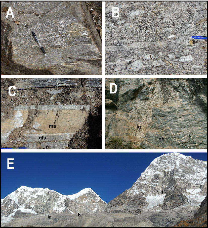
Upwards, the lower structural levels of the GHS-U (or HHC) consist of Grt + Bt + Kfs + Ky/Sil anatectic paragneiss, reported in the literature as Barun Gneiss (Lombardo et al., 1993; Groppo et al., 2012) (Fig. 4A). The Barun Gneiss is overlaid by Kfs + Bt + Sil ± Crd ± Grt anatectic paragneiss (i.e. Black Gneiss: Lombardo et al., 1993): the locally well-developed Crd-bearing assemblages record a progressive decrease of peak-pressure conditions structurally upward (Groppo et al., 2013). The GHS-U also contains bodies of Bt ± Sil ± Grt anatectic augen-gneiss (Fig. 4B), whose abundance significantly increases toward the upper structural levels (Fig. 2). Metric to plurimetric thick layers of calc-silicate granofels and impure marbles (Di + Pl + Qtz + Kfs ± Scp) are also present in the GHS-U (Fig. 4C). Networks of leucogranitic and pegmatitic dikes are intruded in the middle-upper levels of the GHS-U (Fig. 4D), such as those spectacularly exposed in the highest peaks (Fig. 4E).
Figure 4. Mesostructures and lithologies of the Greater Himalayan Sequence
Representative mesostructures and lithologies of the upper portion of the Greater Himalayan Sequence (GHS-U or Higher Himalayan Crystalline). See Fig. 2 for their locations. (A) Grt + Kfs + Ky + Sil anatectic paragneiss (“Barun Gneiss-type”). The main foliation is defined by a peculiar compositional layering, consisting of Qtz + Kfs ± Sil layers alternated with Qtz + Pl + Bt + Grt + Sil layers. (B) Sillimanite-bearing anatectic orthogneiss. (C) Impure marble (ma) and calc-silicate granofels (gfs) (D) Leucogranite dyke (lg) cross-cutting the main foliation of the Bt + Grt -bearing gneiss (gn). (E) Panoramic view of mountain system to the north of the Dudh Kund lake. Leucogranite and pegmatitic dykes (lg) are variably oriented with respect to the main foliation of the gneiss.
From a structural point of view, this sector of the Himalaya is typically dominated by tectonic contacts and composite foliations dipping toward the north at a regional scale. A pervasive lineation, marked by the preferred orientation of minerals such as kyanite, sillimanite and micas, shows often a dip-slip feature. The main foliation is deformed by crenulations and folds, most of them with NE-SW trending axes and axial planes dipping toward the NW. Open folds with N-S trending axes are also recognizable.
The Main Central Thrust Zone (MCTZ), namely the shear zone related to the tectonic juxtaposition of the high-grade GHS-U over the lower grade LHS, is roughly centered on the intensively sheared GHS-L (Mosca et al., 2013). Meso- and microstructural kinematic indicators across the GHS-L mark a consistent top-to-the-S sense of shear at a regional scale. The MCTZ boundaries are not easy to be identified because they do not coincide with sharp ductile tectonic contacts; on the opposite, shearing related to the MCTZ activity variably affects also the adjacent portions of LHS and GHS-U.