Field trip along the NCC
Location of campsites, selected outcrops and samples described along the NCC field trip are reported in Fig. 5.
Figure 5. Location of campsites, selected outcrop and stop, and samples described in the text.

List of campsite: C1, Shivalaya; C2, Garjang-Dhaule; C3, Pani Pakha; C4, Mane Danda; C5, Jata Pokhari; C6, campsite West Dobato; C7, Tare Kharka; C8, Ngeju Kharka; C9, Lhachhewar; C10, Gumdel; C11, Serding. Coordinates of outcrops and samples are reported in the text.
Day 1 - Trek from Shivalaya to Garjang-Dhaule (2-2.5 hours)
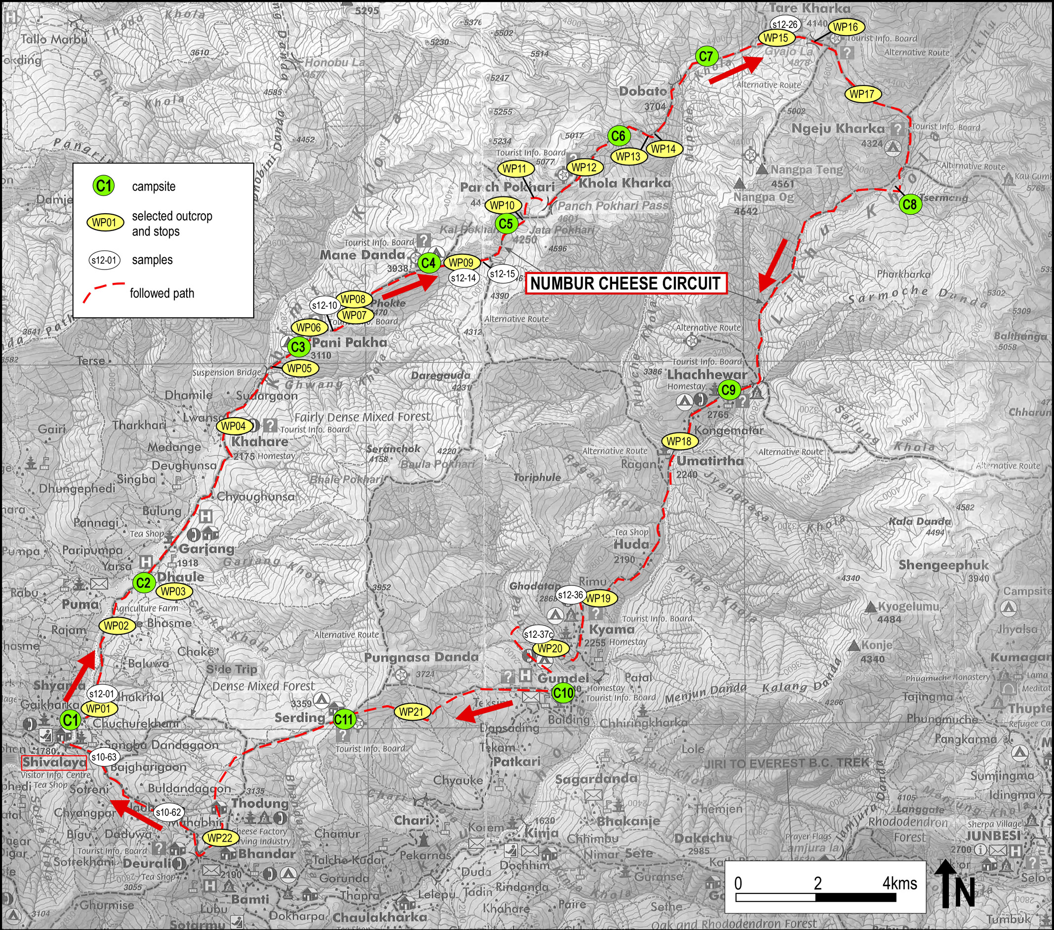
The proposed itinerary along the NCC starts at Shivalaya (campsite C1 in Fig. 5, N 27°36'32.24" E 86°17'43.17", at 1800 m a.s.l.), a nice village along the Khimti Khola river where the motorable road ends (Figs. 6A and 6B). From the geological point of view, the village is located in the lower part of GHS (GHS-L), mainly characterized by Grt-bearing two-micas coarse-grained micaschist and gneiss (Fig. 2).
Figure 6. Trek from Shivalaya to Garjang-Dhaule

(A) The village of Shivalaya on the left side of the Khimti Khola river: this is the starting and the arrival point of the proposed field trip along the NCC. (B) Sketch of the Numbur Cheese Circuit described at the Shivalaya information-point. (C) Intercalation of phylladic micaschist (PHY) and impure marble layers. (D) Detail of the outcrop of Fig. 6C, showing decimetric folds defined by the phylladic micaschists (PHY) and by carbonate-rich levels. (E) Microstructure of the phylladic micaschist shown in Fig. 6D. The main foliation, defined by white mica and biotite, envelops lens-shaped domains containing quartz, calcite and ankerite (sample12-01a) (Plane Polarized Light: PPL).
From Shivalaya, the NCC goes up easily following upstream the left bank of the Khimti Khola. Just outside the village, phylladic micaschist associated to layers of impure marble (Figs. 6C and 6D) are exposed along the road (WP01 - N27°36'33.91" E86°17'56.89"). The phylladic micaschist consists of greenish Bt + Pl ± Wm and contains variable amounts of calcite and ankerite (Fig. 6E-sample12-01, N27°36'33.38” E86°17'54.55”). The main foliation is defined by the preferred orientation of biotite and white mica and locally envelops pluri-mm carbonate-bearing lenses. It dips on average 20-30° to the NE. Impure marble contains variable amounts of quartz, phlogopite and white mica These rocks are deformed along a pluri-metric fault zone, showing normal movements of top down to the NE.
Going up, the trail crosses glacial deposits (lodgment till) involved by shallow landslides (Fig. 7A).
Outcrops of coarse-grained Grt-bearing two-micas gneissic micaschist are exposed in several places along the trail (WP02 - N27°37'27.80" E86°18'20.89"; Figs. 7B and 7C). The gneiss shows a pervasive mylonitic foliation defined by biotite and white mica, enveloping pluri-mm porphyroclasts of garnet. This foliation generally dips to the N and NE and biotite defined a down-dip mineral lineation. Kinematic indicators observed at mesoscale, such as S-C/S-C’ fabrics, record a general top-to-the-S/SW sense of shear (Fig. 7C). The gneiss hosts aplites, ranging in thickness from few cm to some dm, often parallel to the main foliation (Figs. 7D and 7E).
Figure 7. Trek from Shivalaya to Garjang
(A) The path toward Garjang crosses glacial deposits with shallow landslides. (B) Mylonitic Grt-bearing two-micas gneissic micaschists. The main foliation, defined by phyllosilicates, envelops lens-shaped Qtz-rich domains and red garnet crystals up to a few mm in size. (C) S-C fabric in the Grt-bearing two-micas gneiss, suggesting top-to-the-S sense of shear. (D) and (E) Grt-bearing two-micas gneiss exposed near Garjang, showing aplitic levels ranging in thickness from cm to few dm.
The Garjang-Dhaule campsite area (campsite C2 in Fig. 5, N27°37'10.22" E86°25'27.07", at 1920 m) is located at the junction between the alluvial fan of the Chake Khola river and the alluvial plain deposits of the Khimti Khola.
Day 2 - Trek from Garjang-Dhaule to Pani Pakha (6-7 hours)
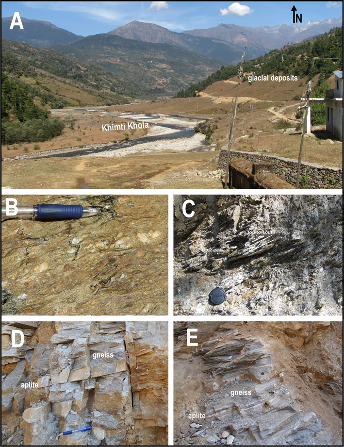
Immediately above the Garjang-Dhaule campsite, some rock walls cropping out on the right side of the Chake Khola (WP03 - N27°38'43.48" E86°19'21.38") offer the possibility to observe good exposures of Grt-bearing two-micas gneiss with aplitic levels. In these outcrops, the gneiss shows a banded structure (Fig. 8A), defined by millimetric to centimetric leucocratic Qtz-rich domains alternating to Bt-rich dark layers. The compositional layering is parallel to the main foliation (Sm), defined by the isorientation of micas (Bt and < Wm), and is cut by networks of mm- to cm-thick aplitic levels with mm-thick Bt-rich selvedges (Fig. 8C). The Sm foliation corresponds to the axial plane foliation of asymmetrical tight folds, evidenced by the aplitic levels (Fig. 8B).
Figure 8. Trek from Garjang to Pani Pakha
(A) Grt-bearing two-micas banded gneiss cropping out in the rock walls above the Garjang campsite (sample 12-03, N27°38'43.48" E86°19'21.38"). (B) Detail of the outcrop reported in Fig. 8A, showing folded aplitic layers within two-micas gneisses. The aplitic layers show mm-thick Bt-rich selvedges. (C) Banded gneiss characterized by quartz-feldspatic domains rimmed by Bt-rich selvedges, suggesting an incipient partial melting. (D) The suspension bridge crossing the Gwang Khola and the cheese factory at the base of the climbing path to Pani Pakha campsite. (E) Panoramic view of the middle Khimti Khola valley from the Pani Pakha campsite.
From the Garjang-Dhaule campsite, the path proceeds quite flat upstream along the Khimti Khola up to Khahare (2180 m), crossing a rural landscape dominated by cultivated fields. After Khahare the trail enters a dense bamboo and rhododendron forest. Few outcrops of banded gneisses, similar to those previously described, occur along this path (Fig. 8C; WP04 - N27°41'0.36" E86°20'24.09"). An incipient partial melting is suggested by both meso- and micro-structures. The main pervasive foliation dips 20-30° to the NE on average, and a mineral lineation plunging to the E and NE is highlighted by biotite aggregates.
After few ups and downs, the trail crosses the Gwang Khola river on a suspension bridge at ca. 2400 m (Fig. 8D; WP05 -N27°41'38.99" E86°21'5.83") and reaches a small cheese factory just before to start the first real ascent of the trek. The Grt-bearing two-micas gneiss exposed near the bridge shows a pervasive foliation dipping on average to the NE and a dip-slip stretching lineation marked by aligned biotite. The gneiss is cut by cm-thick coarse-grained granitic dykes, characterized by the presence of large muscovite flakes. From the bridge, the trail starts to climb in a dense rhododendron forest along the watershed dividing the Khimti Khola from the Gwang Khola river, finally reaching the Pani Pakha campsite (campsite C3 in Fig. 5, N27°41'58.74" E86°21'34.59", at 3110 m). From the campsite the panoramic view toward the Khimti Khola valley is superb (Fig. 8E).
Day 3 - Trek from Pani Pakha to Mane Danda (5-6 hours)
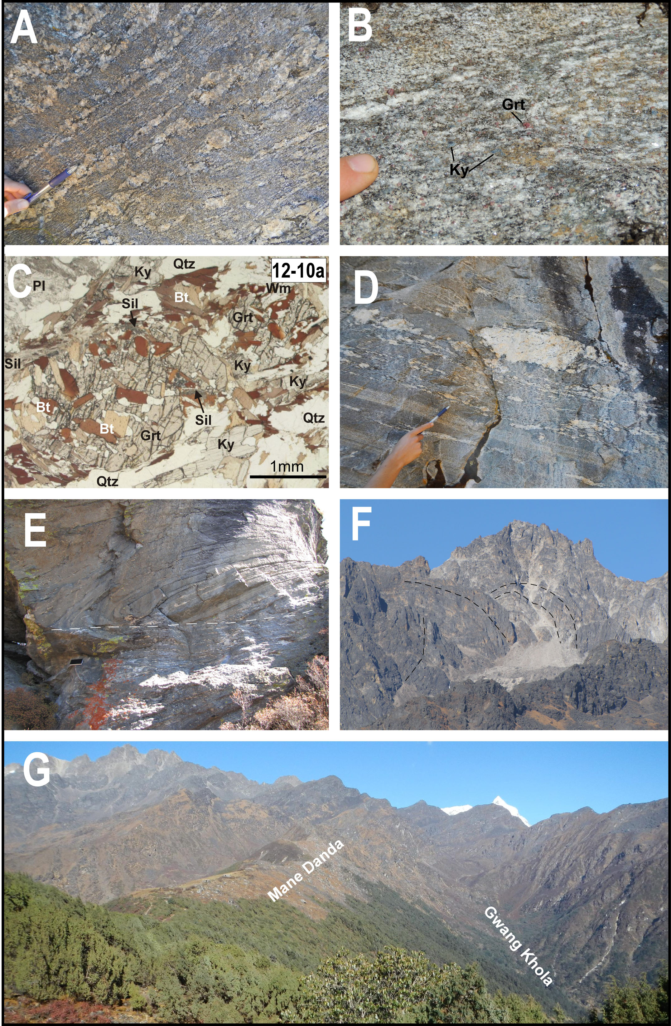
From the Pani Pakha campsite the trail continues to ascent along the watershed through a conifer and rhododendron forest. Incipient anatectic processes are recorded by few outcrops of Grt-bearing two micas gneiss, still ascribed to the GHS-L, exposed along the first part of the path (WP06 -N27°42'12.49" E86°22'9.57"; Fig. 9A).
From the altitude of ca. 3700 m, a lithological change is suggested by the appearance of Grt + Kfs + Ky ± Sil anatectic paragneiss (Figs. 9B-D): this rock, laterally equivalent to the Barun Gneiss, marks the entrance in the upper portion of the GHS (GHS-U), or HHC. A pervasive foliation is defined by mesocratic layers consisting of Bt + Pl + Sil ± Grt ± Ky alternating with cm-thick leucocratic Ky-bearing quartzo-feldspathic layers. It on average dips 20-30° to the ENE and ESE and contains a locally pervasive stretching lineation defined by the preferred orientation of kyanite and/or biotite. Fig. 9C shows microstructural details of the gneiss (sample 12-10, N27°42'18.86" E86°22'25.26"): a mm-sized garnet has inclusions of quartz, biotite, kyanite and plagioclase, partially replaced by Sil + Bt, and muscovite forms late flakes overgrowing the main foliation. Cm-scale intrafolial folds can be recognized, and stretched and deformed Turm + Grt -bearing pegmatites are locally observed parallel to the compositional layering (WP07 -N27°42'24.48" E86°22'32.00"; Fig. 9D).
Figure 9. Trek from Pani Pakha to Mane Danda

(A) Grt-bearing two-micas gneiss showing mesoscopic evidence of incipient anatexis (sample 12-09). (B) Field appearance Grt + Bt + Kfs + Ky ± Sil anatectic paragneiss exposed on the way up to Mane Danda. These gneisses are characterized by the occurrence of mm-sized red garnet and blue kyanite crystals. (C) Microstructure of sample 12-10 showing a mm-sized garnet with inclusions of quartz, biotite, kyanite and plagioclase, partially replaced by Sil + Bt. Muscovite forms late flakes overgrowing the main foliation (PPL). (D) Sheared and boudinated pegmatitic dykes occurring in the anatectic Grt-bearing paragneiss. (E) Outcrop showing a pluri-m scale fold involving calc-silicate granofels and anatectic gneiss. (F) GHS-U gneissic sequence deformed by folds, as identifiable in panoramic view. (G) The Mane Danda pasture along the watershed between the Khimti Khola and the Gwang Khola. The snow-capped peak of the Numbur appears in the back-ground.
At an altitude of ca. 3800 m (WP08 - N27°42'27.53" E86°22'34.29"), an outcrop located on the right side of the path offers the possibility to observe interesting meso-structures of the GHS-U. In the upper part of the rock wall, calc-silicate granofels (Di + Pl + Ep + Kfs + Scp assemblage) and anatectic orthogneiss define a m-scale fold (Fig. 9E). In turn, they are separated from the anatectic orthogneisses of the lower part of the outcrop by a geometrical ductile discordance.
Further on, the path reaches the top of the crest divide, from where the Numbur massif appears behind multicolor prayer-flags. The path continues relatively flat up to the summer pasture of Mane Danda (Fig. 9G) where the campsite is located (campsite C4 in Fig. 5, N27°42'56.59" E86°23'16.32", at 3970 m). This final part of the path offers magnificent panoramic views of the mountains extending to the north (Fig 9G-F). The thick gneiss sequence encircling the upper Khimti Khola results variably folded and deformed by large faults (Fig. 9F).
Day 4 - Trek from Mane Danda to Jata Pokhari (2.5-3 hours)
From the Mane Danda campsite the path runs along the right flank of the Gwang Khola, moving towards the upper part of this valley, characterized by a progressive series of glacial cirques hosting lakes at different elevations (see next days).
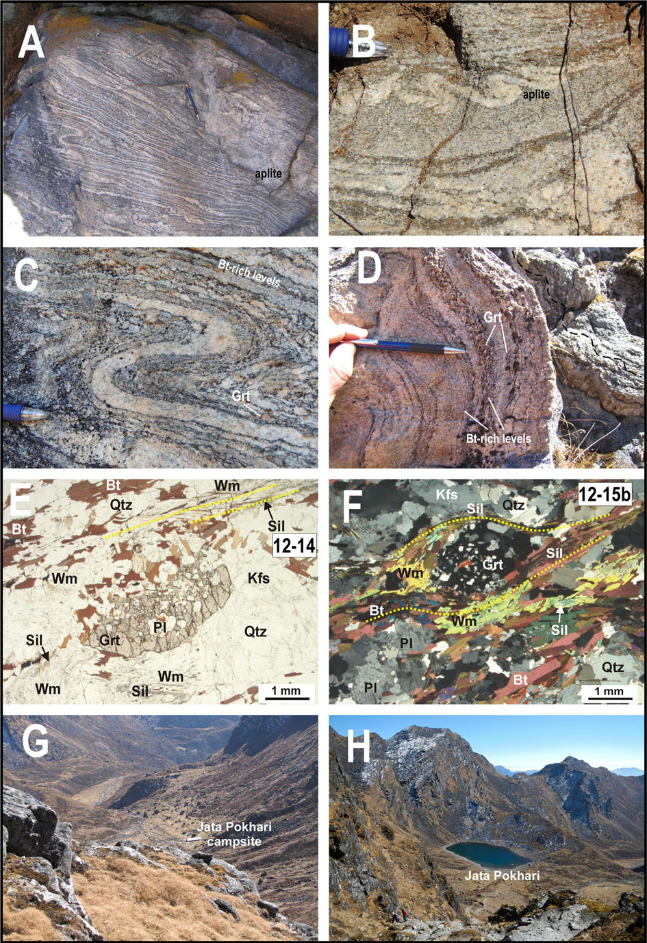
Outcrops and blocks observed along this trail are anatectic gneiss characterized by the assemblage Grt + Bt + Kfs + Sil (Barun Gneiss-type). Field appearance of this gneiss along the path (WP09 - N27°43'2.17" E86°23'52.25") is shown in Figs. 10 A-D. They are characterized by an evident compositional layering, defined by mesocratic layers (Bt + Grt + Pl + Sil) alternating with leucocratic layers (Qtz + Kfs ± Pl ± Grt), cut by discordant pegmatitic and aplitic dykes. The main foliation, parallel to the compositional layering, is defined by the preferred orientation of biotite and sillimanite and envelops porphyroclastic garnet up to a few mm in size (Fig. 10E: sample 12-14, N27°43'2.80" E86°23'52.05"; Fig. 10F: sample12-15, N27°43'6.84” E 86°24'17.48"). White mica typically occurs as coarse-grained late flakes overgrowing the main foliation and replacing sillimanite. The main foliation generally dips to the NE and E and has a down-dip mineral aggregate lineation, but it is variably deformed by close to open folds and crenulations. The Jata Pokhari campsite (campsite C5 in Fig. 5, N27°43'33.33" E86°24'54.09", at 4225 m) is located in a glacial cirque with a lake (Figs. 10G and 10H).
Figure 10. Trek from Mane Danda to Jata Pokhari
(A) Folded anatectic Grt + Bt + Kfs + Sil paragneiss (Barun-type) cut by an aplitic dyke. (B, C) Detail of thin folded aplitic dykes from the same outcrop of Fig. 10A. (D) Anatectic Grt + Bt + Kfs + Sil paragneiss characterized by a compositional layering defined by mesocratic layers alternating to leucocratic layers. A gentle open fold deforms the compositional layering. (E) and (F) Microstructure of samples 12-14 and 12-15, respectively. The main foliation, parallel to the compositional layering, is defined by Bt and Sil, this last partially replaced by coarse-grained late Wm flakes. Pluri-mm Grt includes Pl, Qtz and Bt (PPL). (G) and (H) Panoramic view of the Jata Pokhari campsite from the trail climbing to the Panch Pokhari lakes.
Day 5 - Trek from Jata Pokhari to campsite West Dobato (6-7 hours)
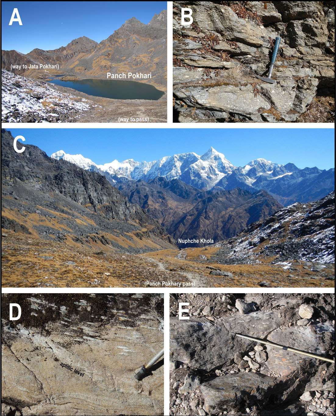
A short climb from the Jata Pokhari campsite allows to reach the sacred Panch Pokhari lakes (4508 m), spectacularly located within a large glacial cirque (Fig. 11A). Every year many Hindu and Buddhist devotees visit this place in August during the Janai Purnima festival.
Along the climbing path (WP10 - N27°43'47.20" E86°24'56.11"), the anatectic Grt + Bt + Sill gneiss (Barun Gneiss-type) shows a main foliation usually dipping 20-40° to NW and NNE. This foliation is folded by tight folds with hinge lines plunging shallowly NE and locally associated to the development of an axial plane cleavage. At the outcrop scale, the “Barun Gneiss” often contains cm-thick sheared and boudinated quartz-feldspathic layers (Fig. 11B; WP11 - N27°43'57.30" E86°25'21.18"). From the Panch Pokhari lakes, the path climbs up to the Panch Pokhari pass (4610 m), allowing spectacular panoramic views of the Numbur massif (Fig. 11C). Then it continues towards the Nupche Khola, a tributary of the Likhu Khola valley.
Figure 11. Trek from Jata Pokhari to campsite West Dobato
(A) View of the Panch Pokhari lakes from the path climbing to Panch Pokhari pass. (B) Anatectic gneiss showing boudinated quartzo-feldspathic layers. (C) Panoramic view of the Numbur Massif from the Panch Pokhari pass. Looking to the east. (D) and (E) Outcrop of fine-grained Kfs + Bt + Sil ± Grt paragneiss (Black Gneiss-type) characterized by peculiar Sil + Qtz nodules up to few cm in size, aligned along the main foliation.
After trekking along the descending path for roughly 200 m, the summer settlement of Khola Kharka is reached (N27°43'54.63" E86°26'13.64", at 4400 m). From there, the path continues to descent: most outcrops and blocks along the trail consist of fine-grained Kfs + Bt + Sil ± Grt paragneiss characterized by aligned Sil + Qtz nodules up to few cm in size (Figs. 11D and 11E; WP12 - N 27°44'10.52" E86°26'29.59"). These rocks are considered as the lateral equivalent of the Black Gneiss defined in the Everest region by Lombardo et al. (1993). The campsite, here informally called campsite West Dobato (campsite C6 in Fig. 5, N27°44'33.46" E86°26'52.18"), is located at an altitude of ca. 4000 m within a large circle partially filled by significant amounts of heterometric blocks (most of them consisting of Black Gneiss-type rocks) from the surrounding steep walls.
Day 6 - Trek from campsite West Dobato to Tare Kharka (4-5 hours)
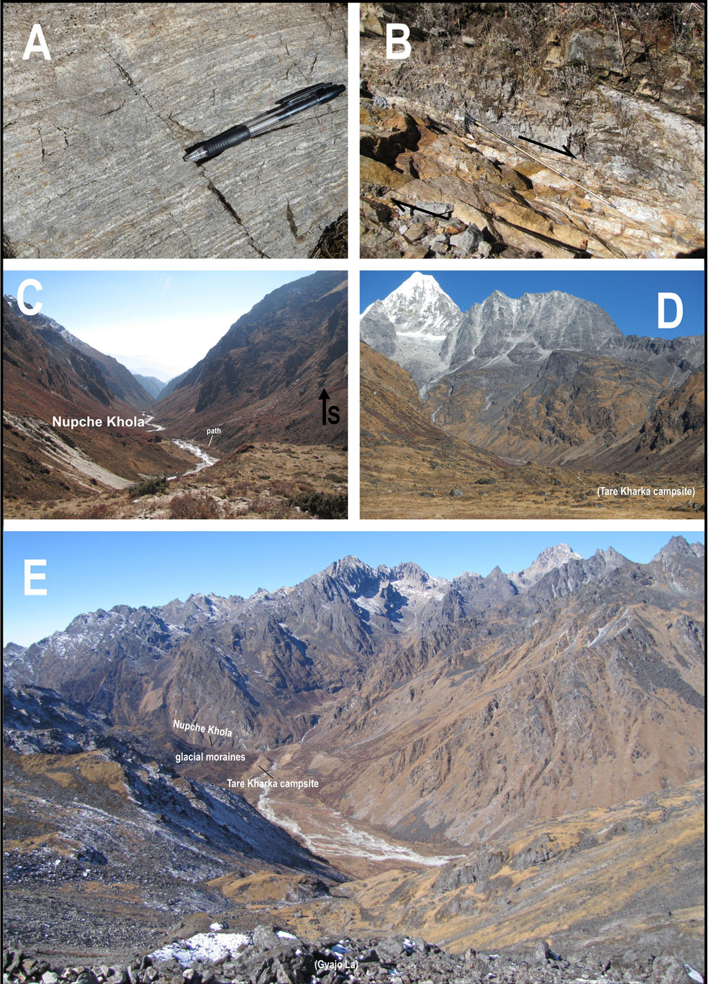
From the campsite West Dobato, the path steeply descends alongside the valley flank towards the Nupche Khola river. Exposures of Bt + Grt + Sil gneiss can be observed at several places. The main pervasive foliation, always parallel to the compositional layering (WP13 - N27°44'24.53" E86°27'15.09"; Fig. 12A), dips on average 30° towards NNW and NE, and a mineral lineation, defined by biotite and/or sillimanite, plunges in the same directions. Along the path, at an altitude of ca. 3800 m (WP14 - N27°44'27.65"N E86°27'22.65"; Fig. 12B) the gneissic sequence is deformed by a m-scale fault zone, characterized by late top-to-the-NE extensional displacements. From there, the path turns northward and moves upstream along the right side of the Nupche Khola valley (Fig. 12C), reaching its bottom at the small summer settlement of Dobato. A little upstream, outcrops of gneiss with Sil + Qtz nodules (Black Gneiss -type) occur, and a number of sub-angular blocks of calc-silicate granofels are found along the mountainside.
Figure 12. Trek from campsite West Dobato to Tare Kharka
(A) Kfs + Bt + Grt + Sil gneiss cropping out along the path descending from campsite West Dobato toward the Nupche Khola river. (B) Late top-to-the-NE extensional fault zone within the anatectic paragneiss. (C) View of the Nupche Khola bottom valley as seen from the path climbing up to the Tare Kharka campsite. (D) Panoramic view of the Numbur Massif looking to the north from the Tare Kharka campsite: the exposed section of GHS-U gneiss is intruded by a network of leucrogranitic dykes. (E) View of the Thare Kharka campsite from the path climbing to Gyajo La Pass
Moving on, the path passes from the right to the left side of the Nupche Khola (bridge at N27°45'42.71" E86°27'35.33"); then it climbs up to the Tare Kharka campsite (campsite C7 in Fig. 5, N27°45'43.52" E86°28'2.94", at 4140 m). The campsite is spectacularly located on a flat alluvial plain bounded by modeled glacial moraines and resting a few hundreds of meters above the Nupche Khola (Figs. 12D and 12E). Looking to the north, the campsite offers impressive views of thick gneissic sequence spectacularly intruded by networks of leucogranitic dykes (Fig. 12D).
Day 7 - Trek from Tare Kharka to Ngeju Kharka (6-7 hours)
This is probably one of the most spectacular day of the proposed itinerary. From the Tare Kharka campsite, the path is quite flat and follows upstream the river for about an hour; then it starts to climb steeply and it finally reaches the Gyajo La pass (also reported as Thulo Lapcha, 4877 m), traditionally used by local Sherpas to move the yaks across the mountains.
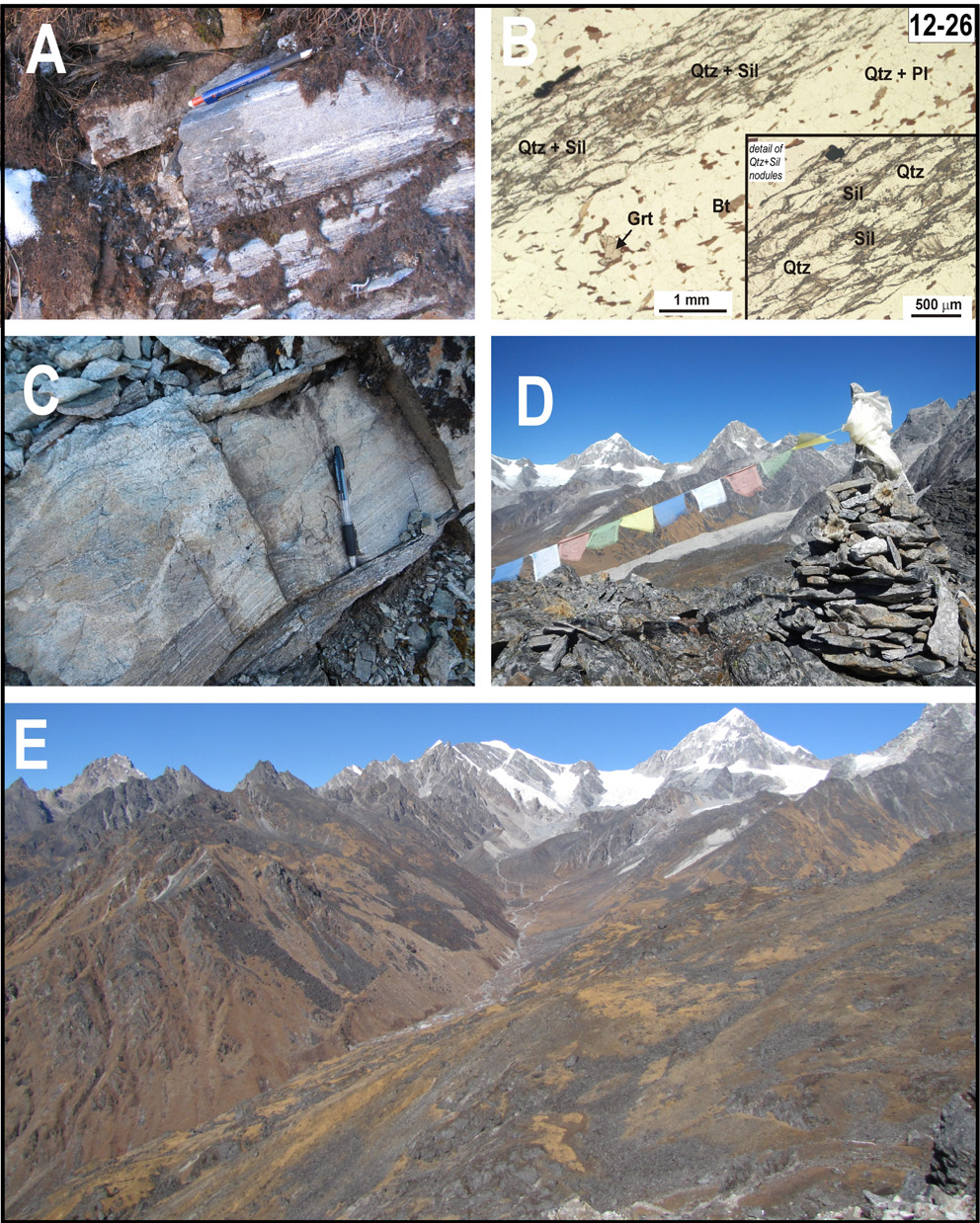
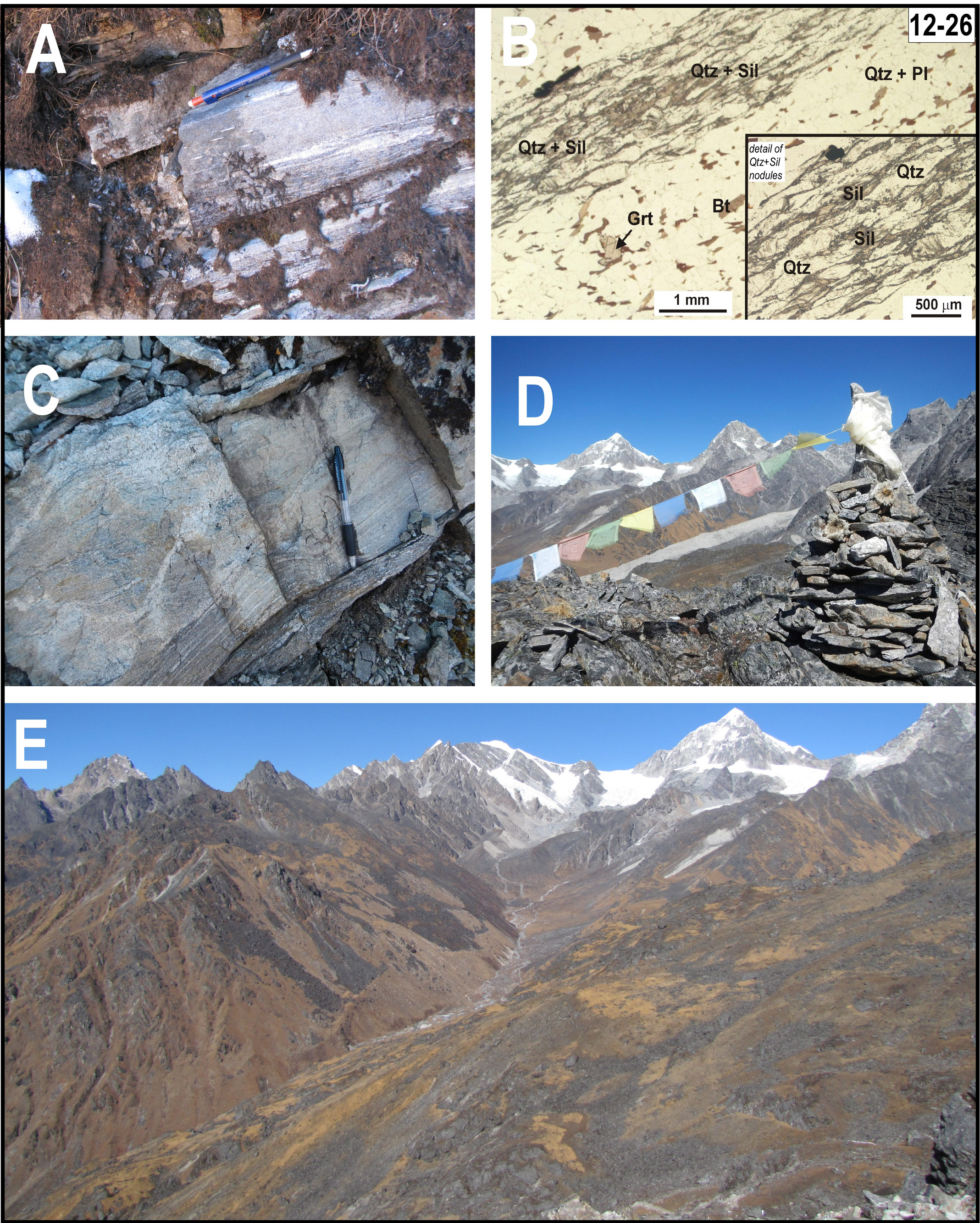
Along the climbing trail to the pass, fine-grained Bt + Grt + Sil gneiss crops out extensively, showing Sil + Qtz nodules up to few cm in size (WP15 - N27°46'3.23" E86°29'5.10"; Fig 13A and 13B, sample 12-26, same coordinates of WP15). The pervasive foliation dips 30-40° to the NE. Calc-silicate granofels (Fig. 13C) occurs as dm-thick layers in this gneissic sequence.
Figure 13. Trek from Tare Kharka to Ngeju Kharka
(A, B) Outcrop (A) and microstructure (B: PPL) of fine-grained Bt + Kfs + Sil gneiss with Qtz + Sil nodules (sample 12-26) cropping out along the path climbing to the Gyajo La Pass. (C) Fine-grained Bt + Sil + Grt gneiss associated to levels of calc-silicate granofels. (D) Prayer flags at the Gyajo La pass (4880 m). (E) Panoramic view of the upper Nupche Khola valley looking toward north from the Gyajo La pass. Note in the distance the frontal glacial moraine cut by the spillway
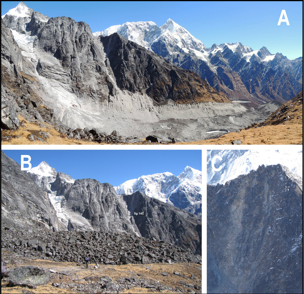
The Gyajo La pass (WP16 - N27°46'3.46" E86°29'40.30") offers spectacular panoramic views of the mountains encircling the upper Nupche Khola valley to the north-west (Figs. 13D and 13E) and of the Likhu Khola valley and the Numbur Massif to the north-east (Fig. 14A). A number of glaciers are present in the uppermost part of the valleys, and their more recent history is spectacularly documented by thick and continuous lateral and frontal moraines (Figs. 13E and 14A).
Figure 14. Trek from Ngeju Kharka to Lhachhewar
(A) Spectacular lateral glacial moraines of a tributary glacier of the main Likhu glacier, seen from the path descending from the Gyajo La pass towards the Likhu Khola. (B) Detail of a supraglacial landlside. (C) Detail of a leucogranite dyke intruded in the GHS-U gneiss.
From the pass, the path goes down following the right lateral moraine of a tributary glacier of the main Likhu Glacier (Fig. 14A). An impressive supraglacial landslide is shown in Fig. 14B. Exposed rocks are anatectic gneiss (Barun Gneiss-type), crosscut by leucogranitic intrusions and dikes of different sizes (Figs. 14B and 14C). The outcropping gneiss is characterized by a foliation usually dipping to the NE and by sillimanite and/or biotite marking pervasive stretching lineation plunging towards the same direction. This foliation is deformed by tight folds and crenulations plunging NNE (WP17 - N27°45'11.29" E86°30'37.47").
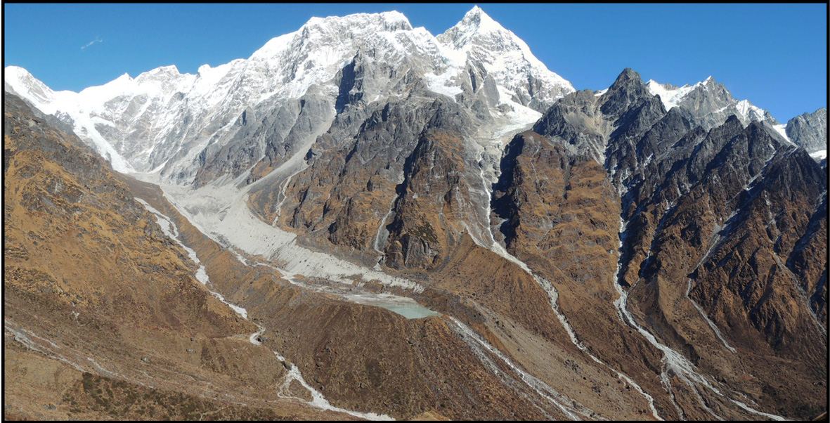
The panoramic view of the Numbur Massif is superb all along the descending path towards the Likhu Khola, and the main Likhu glacier has spectacular glacial moraines, bounding a glacial lake and cut by the spillway (Fig. 15). Several minor glacial moraines are also present along the left side of the valley (Fig. 15).
Figure 15. Trek from Ngeju Kharka to Lhachhewar
Glacial moraines of the main Likhu glacier, bounding a glacial lake and cut by the spillway. The panoramic view of the Numbur Massif is superb all along the descending path towards the Likhu Khola
Once reached the Likhu Khola valley bottom, the path progressively descends downstream along the river. A bridge allows to cross the river (bridge at N27°44'10.01" E86°30'58.83"), thus finally reaching the Ngeju Kharka campsite (campsite C8 in Fig. 5, N27°44'0.81" E86°31'1.66", at 3680 m) located in an flat wooded area on the left bank of the valley.
Day 8 - Trek from Ngeju Kharka to Lhachhewar (4-5 hours)
Once left the Negju Kharka campsite and crossed again the river, the path descends gently along the right side of the Lihku Khola valley through a suggestive rhododendron and coniferous forest, spotted by reddish barberry bushes. The Numbur Massif remains still visible for a while behind us. Few cheese factories are encountered along the path, which is mainly set in the alluvial deposits of the Likhu Khola, consisting of coarse-grained, poorly sorted sediments and large blocks made up of GHS-U lithologies.
The Lhachhewar campsite (campsite C9 in Fig. 5, N27°41'4.44" E86°28'4.61", at ca 2750 m,) is located on a terraced area before the confluence of the Lihku Khola with the Nupche Khola. Lhachhewar is the last village in the upper Likhu Khola valley: this is a nice village, with several stone houses surrounded by cultivated fields.
Day 9 - Trek from Lhachhewar to Gumdel (7-8 hours)
From Lhachhewar campsite the path runs 2 km up and down alongside the valley flank: sub-angular blocks coming down from the near mountain sides consist of anatectic Bt + Grt gneiss (Barun Gneiss -type). Then, the path descends quickly through the forest towards the confluence of the Likhu Khola with its tributary Nupche Khola (Umartina area). Rock faces exposed in the forest (WP18 - N27°40'22.89" E86°27'19.88"; Fig. 16A) consist of anatectic Bt + Grt gneiss with abundant late muscovite flakes. The main foliation is moderately dipping on average towards NE.
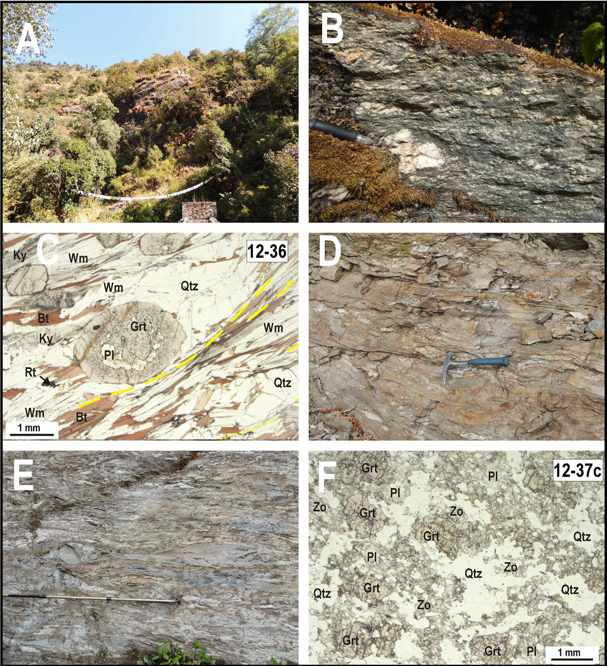
A suspension bridge allows to cross the Nupche Khola river, and then the path continues downstream along the right bank of the Likhu Khola, crossing a rhododendron forest. The lithology is now changed, and Grt + Ky -bearing two-micas gneiss and micaschist mark the entrance in the GHS-L sequence (see outcrop at WP19 - N27°38'24.54" E36 86°25'57.51"; Fig. 16B and 16C; sample 12-36, same coordinates of WP19). The main foliation defined by the isorientation of white mica and biotite, on average dips to NNE; numerous stretched quartz lenses also occur between the foliation planes. Garnet forms pre- to syn-kinematic pluri-mm grains with inclusion of plagioclase and quartz, and post-kinematic kyanite crystals overgrow the main foliation (Fig. 16C).
Figure 16. Trek from Lahaksewar to Gumdel
(A) Outcrop of Bt gneiss at the junction between the Nupche Khola and the Likhu Khola valleys (Umartina area). These rocks represent the lowermost structural levels of the GHS-U sequence. The main foliation is dipping on average toward the north. (B) Grt + Ky gneissic micaschist with the main foliation enveloping Qtz-rich lensoidal domains up to a few cm in size (sample 12-36). (C) Microstructure of Grt + Ky -bearing two-micas micaschist (sample 12-36, PPL). The main foliation is defined by white mica and biotite; garnet forms pre- to syn-kinematic grains with inclusion of plagioclase and quartz. (D) Intensive shearing of Grt-bearing two-micas micaschist cropping out along the road toward Gumdel. (E) Layers of calc-silicate granofels (sample 12-37c) intercalated to Grt-bearing two-micas micaschist and gneiss. The outcrop records an intensive shearing along the main foliation. (F) Microstructure of Grt + Zo -bearing calc-silicate granofels (sample 12-37c, PPL)
After the forest, the path reaches the rural village of Kyama (N27°37'47.60" E86°25'43.09", at 2550 m), located on the terraced right side of the Likhu Khola valley. There is a small Gompa (monastery) just outside the village. From the village, the path becomes a dusty road which descends along the left flank of the Perung Khola valley. A number of outcrops exposed along the road (WP20 -N27°37'46.58" E86°25'27.58") consist of intensively deformed Grt-bearing two-micas gneiss and micaschist (Fig. 16D), with dm-thick layers of quartzite and calc-silicate granofels (Grt + Zo + Pl + Amp assemblage: Figs. 16E and 16F; sample 12-37c, N27°37'46.58" E 86°25'27.58") stretched along a pervasive mylonitic foliation. The foliation dips on average 20-30° towards ENE and NE, and contains a mineral aggregate lineation plunging NE. S-C fabrics indicate a top-to-the-SW sense of shear. A suspension bridge allows to cross the Perung Khola river and the road finally reaches the village of Gumdel (campsite C10 in Fig. 5, N27°37'10.22" E86°25'27.07", at 2250 m), with a lodge and small shops.
Day 10 - Trek from Gumdel to Serding (5-6 hours)
In the morning, the view from the village of Gumdel is very nice, extending from the upper Likhu Khola valley to the Numbur Massif (Fig. 17A). From the village, the path progressively starts to ascend along the right flank of the Likhu Khola valley. The outcrops exposed along the dusty road consist of mylonitic Grt-bearing two-micas gneiss and micaschist, showing variably folded and stretched veins of quartz. Examples of this rocks can be observed in the outcrops exposed along the road on the eastern side of the Chari Khola (WP21 - N27°36'40.41" E 86°23'1.23"; Figs. 17B-D). The mylonitic foliation generally dips 20-30° to the NNW and N, and aligned biotite marks a pervasive down-slip lineation. Kinematic indicators (S-C fabrics) suggest top-to-the-S sense of shear. Evidences of top-to-the-E/NE late extensional deformations (meso-scale faults and associated fractures) are also present in these outcrops.
Figure 17. Trek from Gumdel to Serding
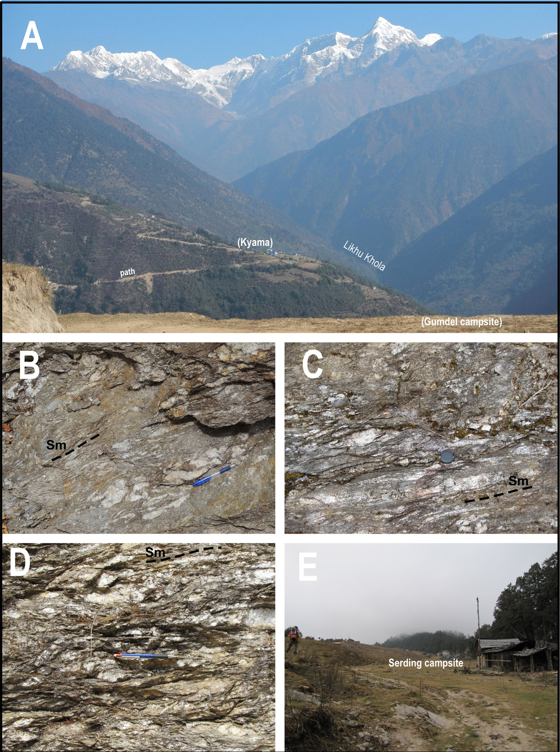
(A) Panoramic view of the Likhu Khola valley and of the Numbur Massif from the village of Gumdel. (B, C, D) Mylonitic Grt-bearing two-micas micaschist, showing folded and stretched quartz veins. (E) The Serding campsite
A steep stairway through a dense virgin forest leads to Serding campsite (campsite C11 in Fig. 5, N27°36'45.04" E86°22'1.05", at 3300 m), located in a nice flat area on the top of a crest between the main Likhu Khola and Khimti Khola valleys.
Day 11 - Trek from Serding to Shivalaya (5-6 hours)
From the Serding campsite, the path steeply descends through a dense forest towards the Deurali pass, offering good panoramic view of the icy mountains to the west (Fig. 18A) Along the descending path, Grt-bearing two-micas gneiss and micaschist are exposed in scattered outcrops (WP22 - N27°35'15.50" E86°20'11.77"; Fig. 18B). They show a main foliation dipping 10-30° towards NW and N, and a pervasive stretching lineation defined by aligned biotite plunging in the same directions. Mesoscopic S-C fabrics suggest a top-to-the-S/SE sense of shear.
Figure 18. Trek from Serding to Shivalaya

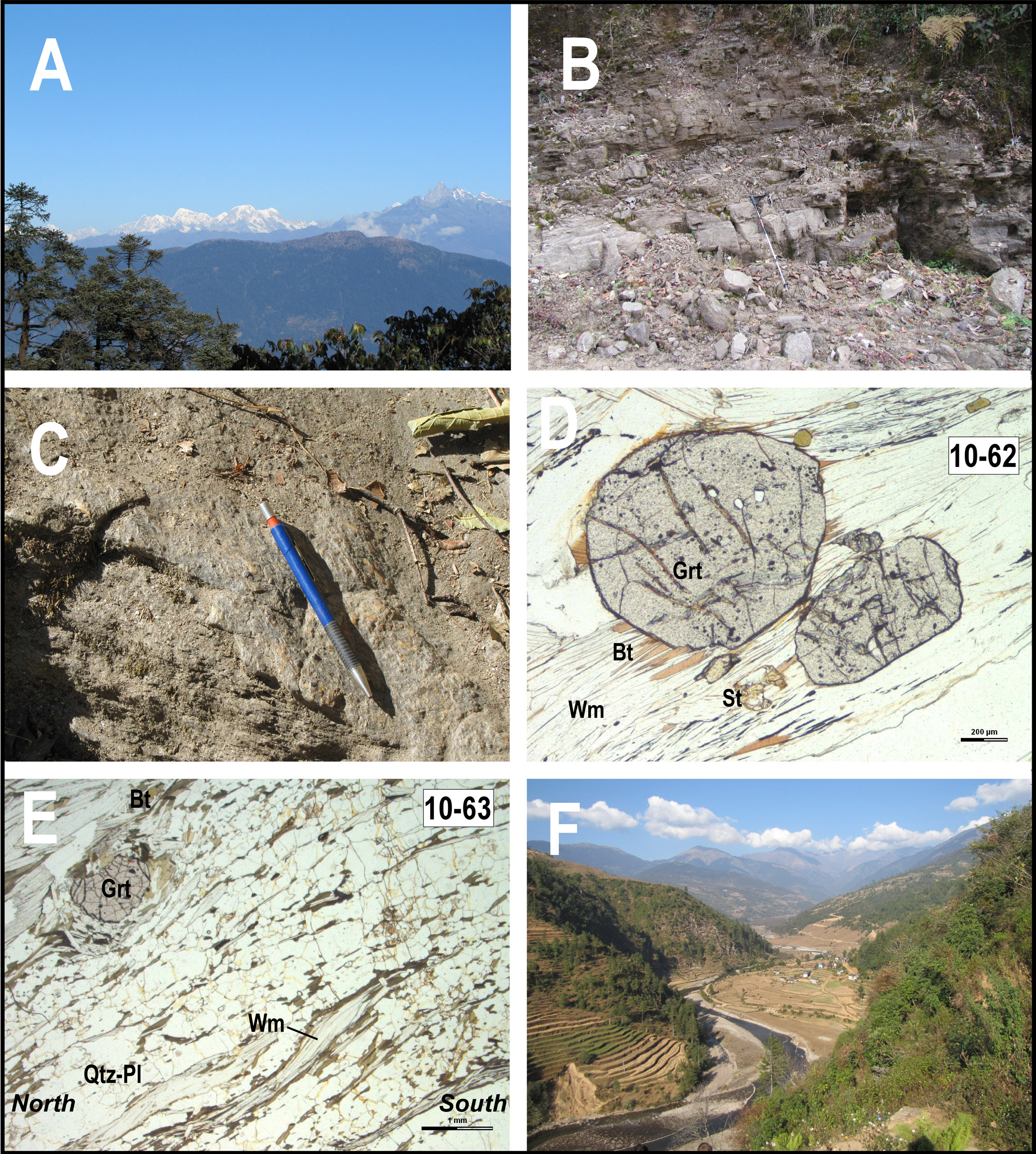
(A) Panoramic view of Himalaya looking to the west from the descending path from the Serding campsite toward the Deurali pass. (B) Grt-bearing two-micas micaschist cropping out along the path toward Deurali pass. (C) Grt+St -bearing two-micas micaschists with a well developed mineralogical stretching lineation (evidenced by the pen). (D, E) Microstructure of Grt ± St -bearing two-micas micaschist (D: sample 12-62; E: sample 12-63; PPL). Note mica-fish in (E) indicating top-to-the-S sense of shear. (F) The arrival in Shivalaya and the last view of the Khimti Khola valley
Immediately before the Deurali pass the path becomes a dusty road again. At the Deurali pass (2710 m), the NCC reaches the main Jiri to Lukhla trekking-route. To close the NCC loop, one may follow the main road toward the west, quickly descending to Shivalaya. Along the road, the exposed Grt-bearing two-micas schist shows a pervasive foliation dipping to the NNW (Fig. 18C). The main foliation is defined by the isorientation of muscovite and biotite. Pluri-mm garnet grains and small staurolite crystals partially overgrow the main foliation (Figs. 18D: sample 10-62, N27°39'46.84 E86°35'11.28; and Fig. 18E: sample10-63, N27°39'54.17" E86°35'7.07”). The general top-to-the- S/SE sense of shear is also revealed by microstructures (mica-fishes in Fig. 18E).
After a final steep descent in the forest, the village of Shivalaya appears along the Khimti Khola river. The descending path offers the opportunity of a last view of the valley with its cultivated fields, and of the sinuous trend of the Khimti Khola river (Fig. 18F).