DAY 5. Lesser Himalayan Duplex
The road may end at the village of Sunkada (N29º30’17.9”; E80º51’23.2”; 1719±107 m) depending on the season, or the road may continue up the Seti River toward Chainpur. This field guide is written as if the traverse is made by hiking from Sunkada. At Sunkada, there is a stretch pebble conglomerate along the road in the Ranimata Formation. The road cuts through the RMT and the rock along the fault is white, sugary, and shattered quartzite (Fig. 8d). Also associated with the RMT is a cataclasite in the Lakharpata Group (Fig. 8e). The road/trail descends 1000 m from Sunkada down to the Kali Gad, passing through exposures of the Lakharparta Group. Underneath the RMT, the stromatolitic Lakharparta carbonate rocks are intensely deformed (Figs. 8f, 9a, 9b) (N29º30’13.7”; E80º53’05.8”; 1027±48 m).
Traverse south down the Kali Gad until the river intersects the Seti River at Deura. At Deura, a klippe of the RMT sheet is intersected again (N29º28’10.4”; E80º53’47.5”; 943±147 m). If one continues south on the Seti River, the entire RMT klippe is traverse and the Lakharparta Group crops out again on the south side of the klippe. However, to get to Chainpur, we will hike northeast up the Seti River. Hiking trails exist on both the south and north sides of the river. It is wise to consult the locals about whether the trail is open on the preferred south side. Northeast from Deura, you will hike out of the Ranimata Formation and cross the RMT into the Lakharparta Group (N29º27’37”; E80º57’05.8”; 850±150 m). On the south side of the Seti River, the RMT and Ranimata Formation are present up in the cliffs. At the village of Rail, the Syangia Formation crops out in the river as a dark, iron-rich quartzite even though the valley walls are composed of the Lakharparta Group.
Spend the night along the Seti River probably not near a village (Camp 5 on Fig. 2).
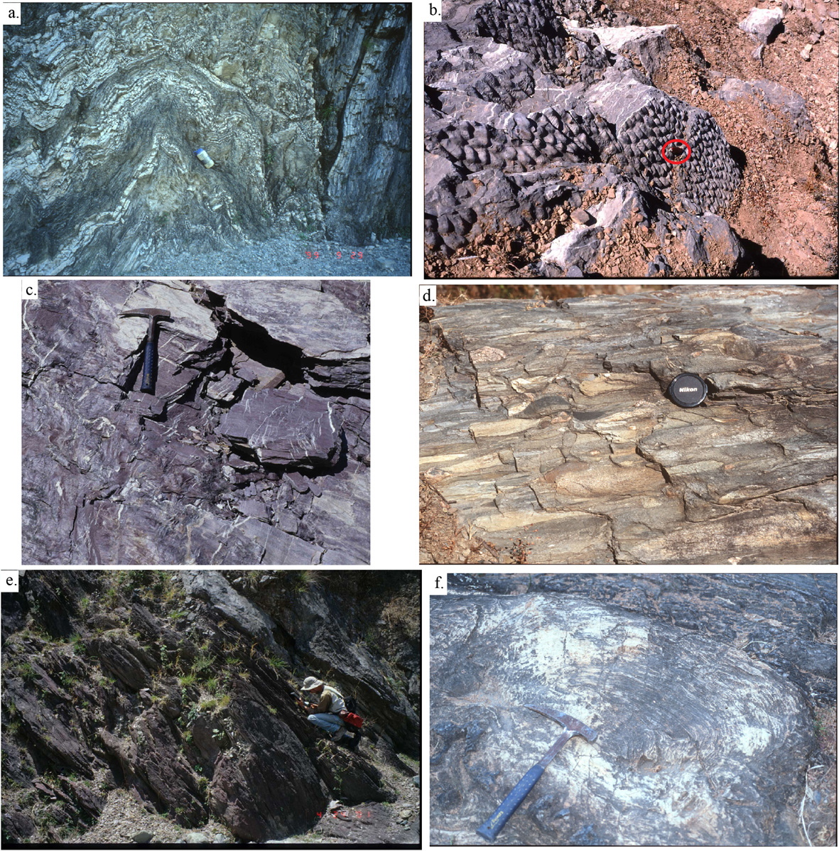
Figure 9. Lakharpata Group
(a) Deformation in the Lakharpata Group carbonate rocks underneath the RMT near the Kali Gad, north of Deura. (b) Bedding plane view of stromatolites in the Lakharparta Group north of Deura. 5 cm red knife for scale has a red circle around it (N29°32’2.5”; E80°44’ 8.5”). (c) Purple shale of the Syangia Formation with white quartz veins along the Seti River, 0.3 m rock hammer for scale (N29°29.543”; E81°04.637’; 3013±161’). (d) Syangia Formation stretched pebble conglomerate. Lens cap is 5 cm in diameter. (e) Dipping Dumri Formation red sandstone with a crouching Bob Gillis for scale (N29°30’08.5”; E81°03’40.2”). (f) Lakharpata Group stromatolites along the Seti River near the village of Malumela. Rock hammer is ~0.3 m long.