DAY 4. Lesser Himalayan Duplex
The Ramgarh-Munsiari Thrust Sheet North of the Dadeldhura Klippe
North of the Dadeldhura klippe, the northern limb of the RMT sheet dips toward the south. At Arnakoli Khola, the Dumri Formation is sandstone and is cut by the RMT sheet (N29°24’8.6”; E80°37’24.7”; 2036±76 m). Based on this cross-cutting relationship and the minimum 15 Ma age of the Dumri Formation at Swat Khola, DeCelles et al. (2001) argued that the age of slip on the RMT must be younger than 15 Ma. Arnakoli Khola is ~130 km north of Swat Khola. Robinson & McQuarrie (2012) suggest that initial deposition of the Dumri Formation at Arnakoli Khola was as early as 25 Ma, but it was cut by the RMT between 16 and 13 Ma.
In far-western Nepal, several previous workers mapped a “Bajang nappe,” another klippe of GH rocks north of the Dadeldhura klippe, near Hat village (Fig. 2; Bashyal, 1986; Amatya & Jnawali, 1996; Upreti & Le Fort, 1999). Our mapping in this region demonstrates the “Bajang nappe” does not exist; instead it is a klippe of the RMT sheet with the Proterozoic augen gneiss intruded into the Ranimata Formation.
The Lesser Himalayan Duplex
All of the LH rocks shown in Figure 5 are exposed in the Lesser Himalayan duplex. We previously discussed the Sangram, Syangia, and Ranimata formations. The rest of the LH rocks will be described as they are encountered along the route of the field trip. On the road to Patan, north of the exposure of Dumri Formation at Arnakoli Khola, is a sequence of tightly folded Sangram and Galyang Formations cropping out along the road (Fig. 8a). Before reaching the town of Patan, another road branches to the northeast that we will follow. The quality of this road depends upon the season. In the monsoon season, the road is frequently impassable.
Galyang Formation
The Galyang Formation consists of ~500-1,000 m of thinly bedded, strongly foliated, olive green, brown, and gray phyllite and black slate with occasional quartz augen. In far-western Nepal, the Galyang Formation contains an ~100 m thick interval of cherty, thinly bedded, siliceous dolostone termed Baitadi carbonates. Small-scale structures include folding and faulting. Although the Galyang Formation bears lithologic similarities with the Ranimata Formation and the Benighat Formation slates (see below), the Galyang Formation is thinner, less metamorphosed, and less chloritic than the Ranimata Formation. The upper contact of the Galyang Formation is not well exposed in western Nepal, but the same lithostratigraphic interval in central Nepal is transitional with the overlying Nourpul Formation, which is similar to the Syangia Formation of western Nepal (Upreti, 1996; DeCelles et al., 2001).
North of the alternating Galyang and Sangram Formations, is a 50-100 km thick outcrop of the Syangia Formation at the village of Mili. The younger-on-older relationship suggests that the contact is a normal fault. The Syangia Formation has purple slate with raindrop imprints and desiccation cracks and transitions upward into the Lakhaparta Group.
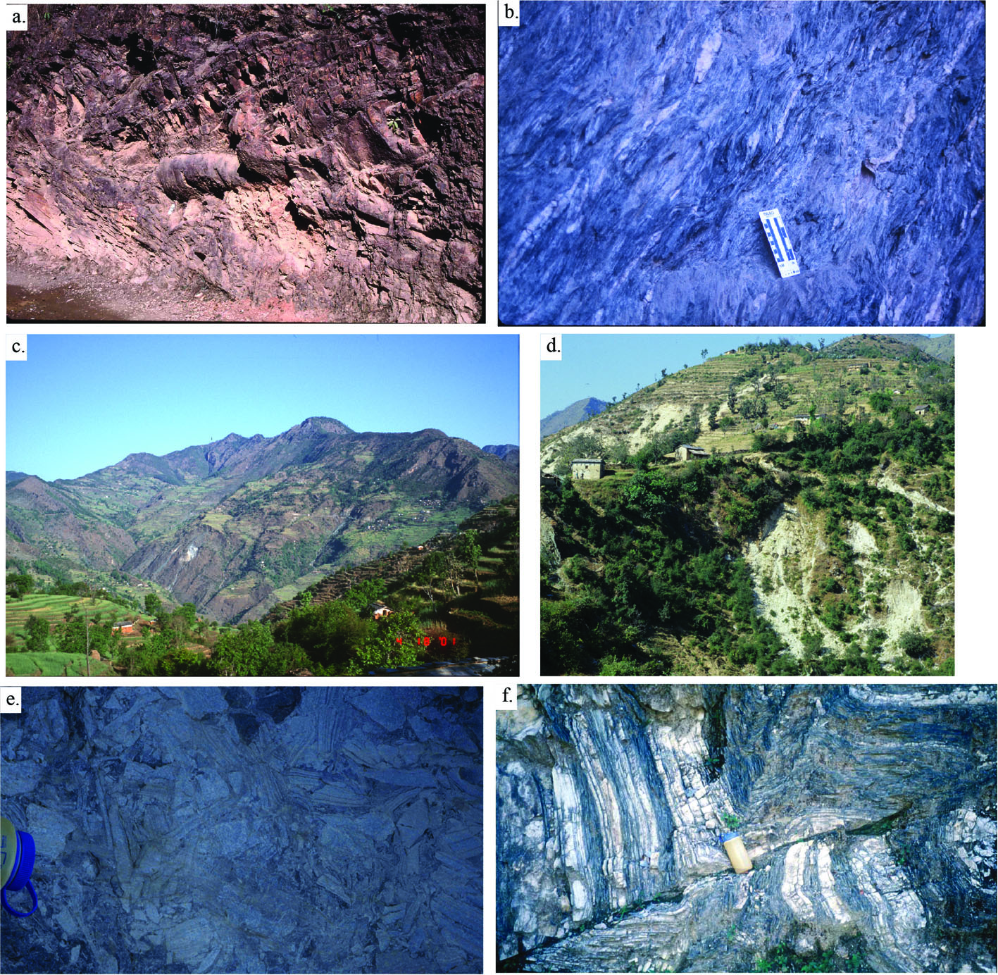
Figure 8. Galyang, Sangram and Ranimata Fms

(a) Example of the meso-scale folds in the Galyang and Sangram formations along the Dadeldhura road, north of Dadeldhura (N29°24’27.6”; E80°37’ 36.9”). (b) Ranimata Formation west of Deulek, showing typical quartz augen in sheared chloritic phyllite matrix. Long edge of scale is 20 cm. (c) Photo is from the village of Deulek looking west into the valley composed of the Ranimata Formation. (d) White schist just west of the village of Deulek. This photo is on the road and shows the shattered white rock that is common along the RMT in western Nepal (N29°32.261’; E80°48.524’; 7151±258’). (e) Cataclasite in the Lakharparta Group underneath the RMT near the Kali Gad (N29°35’59”; E80°54’23.7”; 1359±34 m), top of waterbottle for scale. (f) Deformation in the Lakharpata Group carbonate rocks underneath the RMT near the Kali Gad, north of Deura. One-liter waterbottle for scale (N29°31’47.5”; E80°43’ 39.1”).
Lakharpata Group
Three units compose the Lakharpata Group in far-western Nepal: a lower unit of blue-gray limestone and dolostones; a middle unit of black shale, limestone and dolostones; and an upper unit of blue-gray limestone and argillaceous dolostone. In central Nepal, these units have formal formation status (Sakai, 1985). The main rocks in the Lakhaparta Group carbonate units consist of laminated microcrystalline dolostone; thinly bedded, white quartzite (up to 100 m thick); and minor gray phyllite with occasional limestone beds. Stromatolites are abundant in both the upper and lower carbonate units. The middle black shale unit is probably equivalent to the Benighat Formation slates of central Nepal (Stöcklin, 1980; Sakai, 1985) and consists of black shale/slate, thin gray calcareous siltstone beds, gray phyllite, and black micritic beds. In far-western Nepal, the thickness of the Lakharpata Group is difficult to determine because it is intensely deformed. However, mapping suggests a thickness of ~3 km. The upper contact of the Lakharpata Group is a major unconformity with the overlying Gondwanan and/or Tertiary units.
This road travels along the ridge with deep valleys on either side of the road. North of the intensely deformed Lakharpata Group, the RMT crops out against the Benighat Formation (N29º32’13”; E80º46’40”). The road goes through the Ranimata Formation and the villages of Deulek (Figs. 8b, 8c). Camping near Deulek (Camp 4 on Fig. 2).