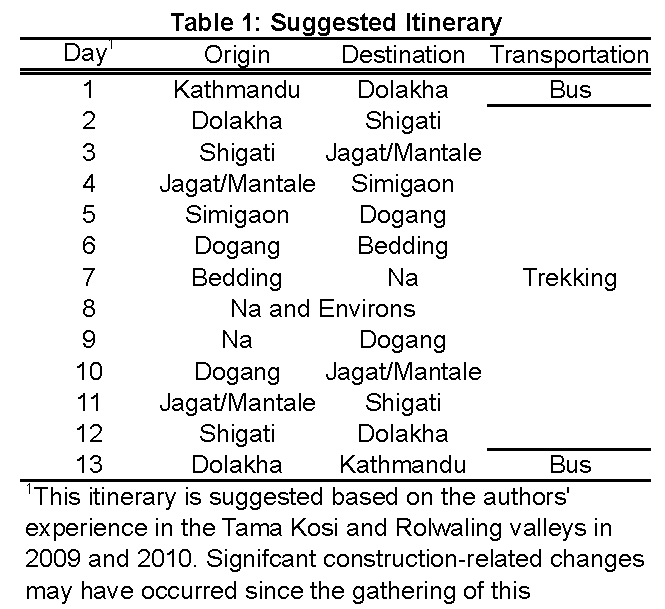
Field Guide and Suggested Field Stops
A start from Dolakha begins the field trip at a higher structural level than a start from Shigati (Figures 1 and 3). Dolakha town is built on a ridge that is capped by mylonitic augen orthogneiss (Figure 3) that is equivalent to the Melung augen gneiss of Ishida (1969) and Schelling (1992) (Table 2) and to the Ulleri and Phaplu orthogneisses elsewhere along the orogeny (Schelling, 1992). The main bus route from Dolakha to Shigati cuts progressively down section across the orthogneiss providing local fresh exposures of the rock in road cuts.
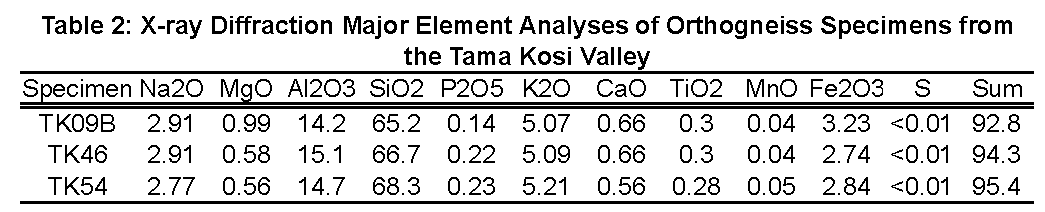
Figure Table 2. X-ray Diffraction Major Element Analyses of Orthogneiss Specimens from the Tama Kosi Valley
Optional Stop - Dolakha (N27.68129˚, E086.07209˚)
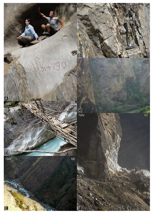
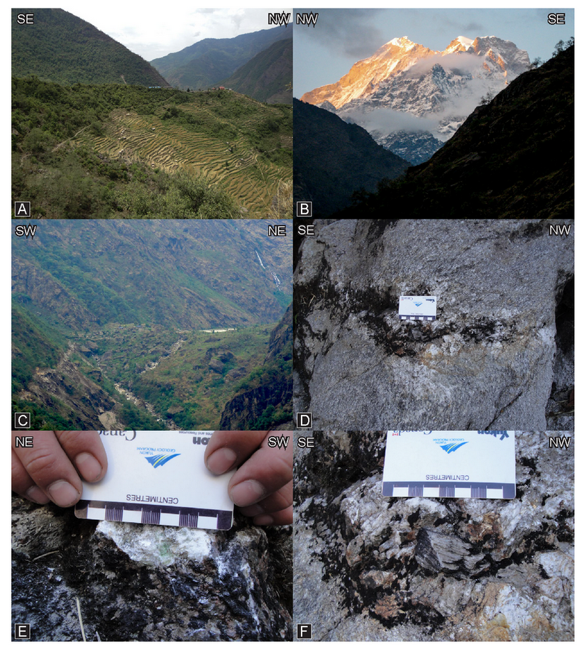
If you are traveling to Shigati from Dolakha there are numerous opportunities to examine the augen orthogneiss. Relatively new exposures along the road, however, afford a unique opportunity to examine ‘fresh’, less weathered material. As shown in Figure 5A, fresh outcrops of the mylonitic orthogneiss are typically composed of quartz + alkali feldspar + muscovite + plagioclase + biotite. Dark biotite grains that help define the stretching lineation in hand sample (locally an L tectonite), are easily picked out against the lighter quartz and feldspar (Figure 5A). Moreover, the fresh exposure allows the recognition of local leucocratic anatexite pods that are otherwise difficult to distinguish in weathered exposures. These pods typically cross-cut the mylonitic foliation and lineation, but do record some deformation. As such they are interpreted to be late synkinematic (i.e. likely Miocene) (Figure 5B). There are as yet no direct age constraints for these anatexite pods.
Figure 5. Field photographs from Dolakha
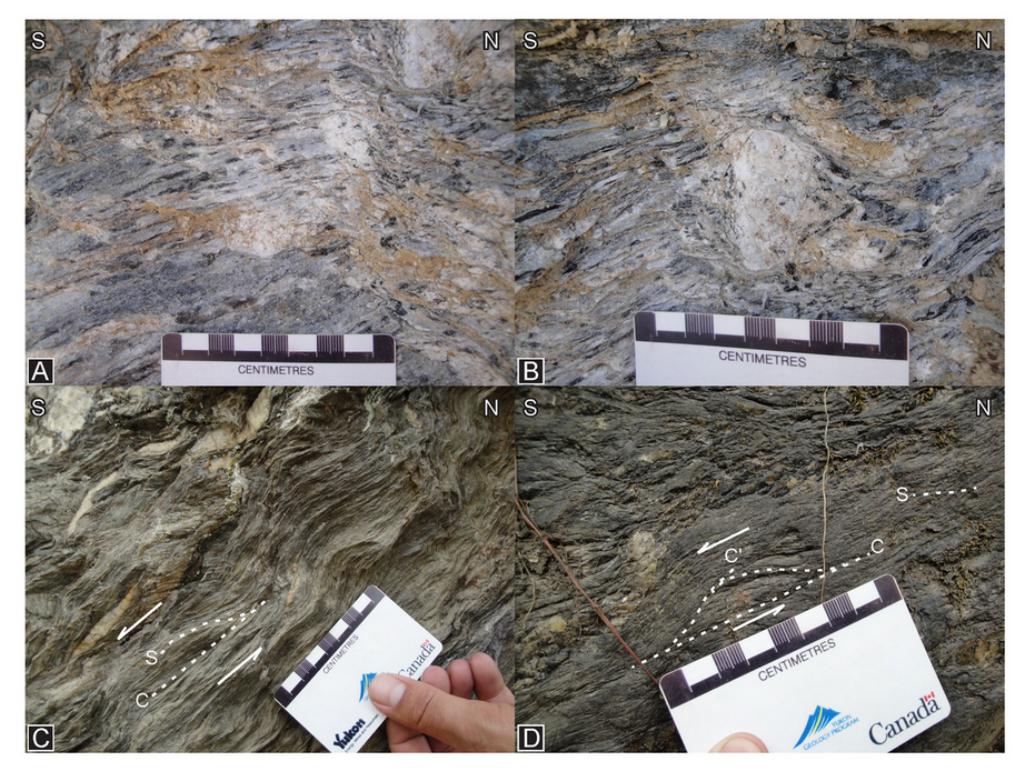
A) Orthogneiss near the town of Dolakha. B) Leucogranite pod within the same orthogneiss shown in A. C) Planar fabric elements indicated top-to-the-south shear in phylitic schist. D) Planar fabric elements indicated top-to-the-south shear in phylitic schist.
Structurally below the augen gneiss, on the way to Shigati you will pass a garnet-bearing quartz + muscovite ± biotite phyllite that is locally intercalated with a fine to medium grained meta-sandstone (Larson, 2012). This lithology has yet to yield any thermobarometric data and no useful chronometers such as zircon, monazite and apatite have yet been found. The only potentially useable mineral for U-(Th)/Pb geochronology found was allanite, but major problems with common Pb contamination prevented extracting meaningful age data. The phyllite does, however, have planar deformational fabrics such as S, C, and C’ structures (Figures 5C, D). These fabrics typically define a top-to-the-south sense of shear (Larson, 2012).
Day One - Lower portion of the exhumed metamorphic core
The rocks traversed in this section comprise part of the Midland Group of Ishida (1969) and are here interpreted here as the lower part of the Himalayan metamorphic core. The rocks traversed on Day 1 record synkinematic metamorphism along a burial path during the Middle Miocene (Larson et al. 2013).
+++ (Shitagi) Stop 1 - North of Shitagi (N27.73971˚, E086.16861˚)
Shitagi village is located at approximately the lowest structural position described in this field guide. The area around the town, and as far north as the village of Suri Doban (Figure 3), is underlain by orthogneiss termed the Suri Doban orthogneiss by Ishida and Ohta (1973) and Schelling (1992). The Suri Doban orthogneiss is locally an augen gneiss, but is more commonly fine-to-medium grained with quartz + alkali feldspar + plagioclase + muscovite + biotite ± chlorite with accessory apatite and epidote. Preliminary geochemical analyses (discussed in Stop 3 below) confirm the mineralogical differences and unique structural position of the Suri Doban orthogneiss relative to the structurally higher Melung orthogneiss.
The orthogneiss at the listed stop location is fine-to-medium grained and augen are absent. Locally preserved small (cm-scale) augen can be observed in outcrops exposed farther north along the trail, though they are measurably smaller and less abundant than augen of the Melung orthogneiss. At the stop location, which, unfortunately, may be hidden behind a rock bail wall now, but was still accessible in 2010, the orthogneiss is intruded by a leucogranite dyke (Figures 6A, B). The leucogranite dyke is generally discordant to the main foliation, though it does show evidence of shear sub-parallel to the foliation plane (Figure 6C). Moreover, the dyke has a dark fine-grained rind (Figure 6C), the nature of which could be related to differential shearing and strain localization, localized contact metamorphism, or, perhaps, marks a melanosome in which case the dyke indicates in situ partial melting. It is not known if this leucogranite is related to the leucogranite pods noted in section 3.1 within the Melung augen orthogneiss.
Figure 6. Field photographs from Shitagi

A) Deformed leucogranite dyke (white colored rock) cutting orthogneiss. People for scale. B) Deformed leucogranite dyke within orthogneiss. C) Close-up photograph of the margin of the leucogranite dyke with the orthogneiss. D) Variably disaggregated, stromatic leucogranite in schistose rocks (from Larson, 2012). E) Apparent compositional layering in quartzite. F) Leucogranite within biotite-rich schist; hammer is 36 cm long. G) Leucogranite lens with biotite-rich rims in quartz + biotite schist (from Larson, 2012)
Stop 2 – North of Suri Doban (N27.75690˚, E086.193320˚)
The area around Shigati is underlain by the Suri Doban orthogneiss and represents the core of a structural culmination located in the southern part of the map area along the Tama Kosi river (Figure 3). To the north, near Suri Doban, the effects of this structural culmination are no longer reflected in the orientation of the dominant tectonic fabric; almost all foliations now dip to the north (Figure 3).
This stop is to visit an outcrop of phyllite that separates the two orthogneiss units. As discussed above, the phyllite is intercalated with meta-sandstone lenses. The meta-sandstone at this site is unique in that it is a relatively pure quartzite, whereas most lenses are more typically arkosic. C/S/C’ fabrics are visible in outcrop and continue to define a top-to-the-south sense shear.
Stop 3 – Melung Augen Orthogneiss (N27.78451˚, E086.21161˚)
Those who chose to start their trip in Dolakha should find the rocks in this outcrop familiar, as this is the same quartz + alkali feldspar + muscovite + plagioclase + biotite augen orthogneiss horizon of Melung augen orthogneiss that can be followed southward to the town of Dolakha. The alkali feldspar augen in this outcrop are particularly large and act as winged porphyroclasts further confirming the top-to-the-south shear sense indicated by the C/S/C’ fabrics observed structurally below.
Whole rock geochemical analyses (Table 3) further differentiate between the Melung and Suri Doban orthogneiss units. The percent oxide values presented in Table 3 were obtained through loose powder X-ray diffraction analyses. Specimen TK09B was sampled from the structurally lower Suri Doban orthogneiss while specimens TK46 and 54 were taken from the Melung augen gneiss. Mg and Fe oxides in the Suri Doban specimen are significantly lower than those from the Melung specimens (Table 3). As well, the Al and P oxides for the Suri Doban specimen are significantly lower than those in the Melung specimens.
Quartz lattice preferred orientation at a slightly higher structural level within this orthogneiss defines an asymmetric crossed girdle fabric (Figure 7A; specimen TK-46) that supports the overall top-to-the-south shear sense noted at the outcrop scale. Furthermore, the opening angle of the fabric measured across the foliation pole indicates that plastic deformation recorded in the recrystallized quartz grains occurred at ~625 ± 50 ˚C (Figure 7D; Larson et al., 2013).
Figure 7. Melung Augen Orthogneiss
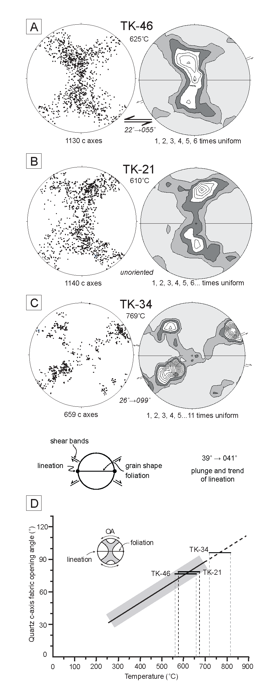
A-C) Quartz crystallographic preferred orientation fabrics for specimens from the field area from low to high structural levels. See text for discussion. Deformation temperature is shown with the fabrics as derived from the graph in D (modified from Morgan and Law, 2004)
Stop 4 – Phyllitic Schist (N27.807603˚, E086.224828˚)
NOTE – The latitude and longitude values for Stop 4 are approximate as they are derived from a best-approximation, plotted position of this outcrop on a trekking map. From the previous stop (3) to this one, the bedrock is dominated by the Melung orthogneiss with rare intercalations of metasedimentary rocks. The orthogneiss gives way up structural section to phyllitic schist and schistose phyllite. These metapelitic rocks are well-foliated and retain evidence of transposed compositional layering. They also host partially disaggregated, plastically deformed quartz-rich dykes or veins (Figure 6D). An outcrop from a similar structural level on the ridge located on the west side of the river contains staurolite porphyroblasts (Figure 1; co-ordinates are provided below). One specimen from that outcrop (TK45) has been analysed using isochemical phase equilibria modeling and yields a peak temperature between ~ 610-650 ˚C at a pressure between 625 and 700 MPa (Larson et al., 2013). These results are consistent with nearby estimated deformation temperatures (see previous stop) indicating that deformation was likely coeval with near peak metamorphism, an interpretation supported by the synkinematic microstructure of the staurolite porphyroclasts (Larson et al., 2013). Furthermore, monazite grains from both the matrix and within staurolite grains yield ages ranging between c. 10 and 8 Ma, which indicates that metamorphism and deformation occurred in the Late Miocene. The pressure-temperature-time path interpreted for these rocks is consistent with paths modeled for the foreland part of a deforming orogenic wedge (Figure 8A; Larson et al., 2013). This is compatible with recent studies that interpret the lower portions of the exhumed Himalayan mid-crust as having been deformed and metamorphosed primarily as part of a foreland thrust wedge (e.g. Larson et al., 2010; Yakumchuk and Godin, 2012; Larson et al., 2013).
Figure 8. Interpreted pressure – temperature – time paths
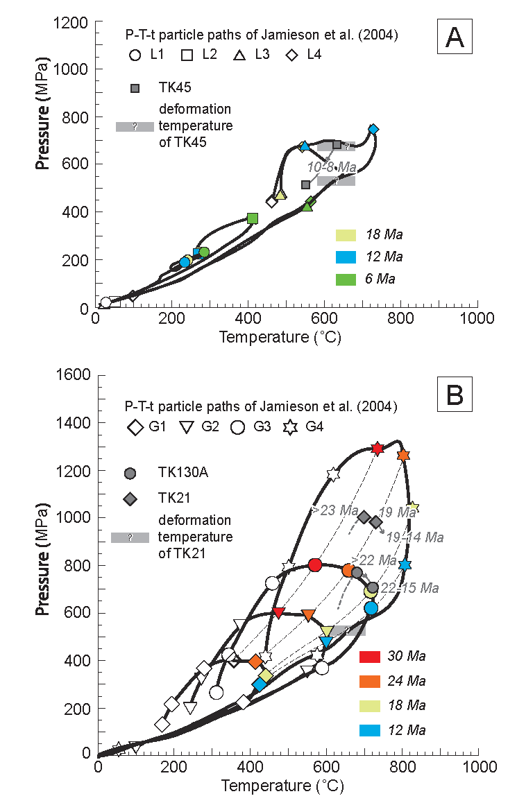
Interpreted pressure – temperature – time paths for rocks collected below major discontinuity (A) and above major discontinuity (B). Modified from Larson et al. (2013). See text for discussion.
On the way back at the end of this trek it is possible to follow a trail from near Gongar up onto the ridge towards the town of Bulung (Figure 1). Doing so would allow a visit to the staurolite-bearing outcrop (N27.79786˚, E086.19167˚) for which the pseudosection was developed, as well as a visit to an outcrop of a graphitic schist unit (N27.80990˚, 086˚20252˚) that is noted elsewhere in the region, but does not crop out along the river (Larson, 2012).
Jagat/Manthale – A Structural Discontinuity
The towns of Jagat and Manthale span a major river crossing and mark one of the most interesting features in the geology of the region. South of the towns the rocks are staurolite grade and lower, with little anatexite. North of the towns the rocks are kyanite grade and higher, and typically contain ≥15 % anatexite by volume. The change in character of the rock, which occurs approximately at Manthale/Jagat, marks the location of a major discontinuity. Rocks below the discontinuity generally record Late Miocene synkinematic metamorphism with characteristics consistent with a burial path typical of those formed in a foreland thrust wedge (see Stop 4; Larson et al., 2013). In contrast, the kyanite and higher-grade rocks above record a protracted Early to Middle Miocene metamorphic history (to be discussed at upcoming stops) and display characteristics consistent with lateral mid-crustal flow processes (e.g. Beaumont et al., 2001; Jamieson et al., 2004). For a detailed discussion of the discontinuity see Larson et al. (2013) and references therein.
Day Two
On this day one follows the river from Manthale/Jagat northward into the hanging wall of the discontinuity described above. The trek does not cover much horizontal ground today, but finishes with a sustained ascent to the town of Simigaon.
Stop 5 – Quartzite (N27.81643˚, E086.22607˚)
This outcrop is located within the town of Manthale/Jagat on the west side of the river; it is a slab of quartzite on the trailside. The rock here is a light to medium grey-weathering quartzite sparsely intercalated with phyllitic schist. Thin biotite partings in the quartzite help mark a moderately northeast dipping foliation plane (Figure 6E). The quartzite forms a useful marker unit that can be traced across a number of valleys in the region (Figure 3) and appears to extend into adjacent drainages (From and Larson, in press). Little evidence of anatexite is recorded in these rocks, likely a function of the relatively infertile protolith.
Aluminosilicate minerals first appear north of this outcrop as the trail leads up structural section. Keep an eye on the outcrops as you travel to the next stop. Generally, the aluminosilicates first appear in close association with leucogranite pods.
Stop 6 – Leucosome-bearing Biotite-rich Schist (N27.88638˚, E086.21870˚)
Recent roadwork has revealed a fresh exposure of biotite-rich schist with abundant leucocratic material (Figure 6F). This leucocratic material, which comprises a significant volume of the overall rock, may be disaggregated anatexite reflecting in-situ partial melting. Such an interpretation is supported by the presence of a biotite-rich residuum around larger leucosome lenses (Figure 6G). The anatexite pods appear to behave as semi-rigid porphyroclasts and record a dominant top-to-the-south sense shear. This shear sense is confirmed by the asymmetry of secondary foliation planes (C/S/C’) within the schist itself.
Stop 7 – Kyanite schistose gneiss (N27.85055˚, E086.21867˚)
The specimens collected from this outcrop (Figure 9A) have been subject to phase equilibria modeling, in situ U-Th-Pb monazite dating, quartz petrofabric analyses, and are currently being processed for 40Ar/39Ar analyses. The rock here is a kyanite + biotite + garnet + muscovite pelitic schistose gneiss. It records a clockwise pressure-temperature-time-deformation (P-T-t-D) path that includes peak pressure conditions of 970 – 1050 MPa associated with temperatures of ~700-725 ˚C (Larson et al., 2013). These conditions were reached between c. 23 and 19 Ma immediately after which the rock records decompressional heating leading to the breakdown of garnet and the growth of kyanite at c. 18 Ma (Larson et al., 2013). Younger monazite age data are consistent with further decompression and significant anatexis (Figure 9B) until c. 15 Ma. Quartz lattice preferred orientation data from this outcrop (Figure 7B) indicate that deformation took place at a temperature of 610 ± 50 ˚C (Figure 7D; Larson et al., 2013). C/S/C’ fabrics recorded in outcrop indicate that deformation was associated with a top-to-the-south shear sense (Figure 5E of Larson, 2012; Figure 9B). The 610 ± 50 ˚C deformation temperature estimated from quartz c-axis fabric opening angle data is significantly lower than the calculated metamorphic temperatures. This indicates that the deformation recorded occurred after peak metamorphism along the cooling path and likely in the subsolidus after c.15 Ma. The P-T-t-D path derived from this outcrop fits well with model paths from thermo-mechanical simulations of lateral midcrustal flow within the Himalaya (Figure 8B; Larson et al., 2013). This is consistent with the interpretation of a tectonometamorphic discontinuity separating these rocks from those structurally lower in the section.
Figure 9. Kyanite and sillimanite schistose gneiss
A) Abundant leucogranite (white lenses) within the high-grade rocks. B) Leucogranite and associated biotite-rich residuum (hammer is 36 cm long). C) The staircase leading up to Simigaon as viewed from the west side of the Tama Kosi valley. D) A local bridge spanning part of the Rolwaling River near its confluence with the Tama Kosi. E) Cliffs with a trail network across it visible near the base. F) Construction of the road on the west side of the Tama Kosi valley leading toward Lamabagar.
Stop 8 – Sillimanite schistose gneiss (N27.87187˚, E086.22228˚)
The quality of the outcrop at the specified coordinates is poor. However, you will encounter similar rocks as you work your way up the staircase (Figure 9C) leading to Simigaon – the rest stop for the day – so it is useful to describe them at the present location. The stop also acts as a crossroads where the trail diverges in two directions. One leads up and to the east into the Rolwaling valley while the other leads up and to the north, following the Tama Kosi valley up to the town of Lamabagar and beyond to its head wall. The trail north used to be a precipitous journey with traditional Nepali bridges and walkways precariously clinging to cliff-sides (Figure 9D and E). Now, however, if you wish to head north you can follow the road that has been carved out of the mountainside (Figure 9F).
The rock at this stop and on the climb to Simigaon is dominantly sillimanite + biotite + garnet + muscovite-bearing migmatitic paragneiss; leucosome comprises a significant volume of the rock. Foliation is defined by preferred orientation of mica in the rock and strataform leucosomal layering, while macroscopic lineation is often marked by aligned sillimanite and muscovite grains. Where present, shear sense indicators in these rocks continue to indicate a top-to-the-south shear sense.
Simigaon
Simigaon is an idyllic village located on the apex of a ridge high above the confluence of the Tama Kosi and Rolwaling rivers (Figure 10A). The views from Simigaon are excellent and on clear days the high Himalaya can be seen (Figure 10B). Moreover, a view up the Tama Kosi valley to the north toward the village of Lamabagar shows that the flood plain the village is built atop was created when the Tama Kosi valley was blocked by a large landslide (Figure 10C). From Simigaon this trek now leaves the Tama Kosi valley and begins an almost west-to-east transect across the high-grade metamorphic core of the orogen through the Rolwaling valley. The dominant orientations of the tectonic foliation and unit contacts also rotate slightly such that we continue to walk largely oblique to strike (Figure 3).
Figure 10. Field photographs from Simigaon and leucogranites from stop 11

A) The village of Simigaon. B) Gauri Shankar Himal. C) View towards Lamabagar from the south. The village is built on landslide deposits that filled the valley floor. D) Late anatexite cross-cutting foliation (from Larson, 2012). E) Cordierite (green mineral) within late anatexite. F). Pegmatitic muscovite booklet within late anatexite.
Day Three
The trek today involves a fair amount of hiking along well-worn paths through forest. As a result, outcrop is limited. The rocks that have been examined on this stretch of the trek, however, have provided key constraints on the metamorphic and geochronologic history of the area.
Stop 9 - Sillimanite migmatitic schistose gneiss - (N27.88244˚, E086.23951˚)
The first stop exposes similar rocks to those observed at the base of the hill beneath Simigaon (Stop 8), though at a different structural level. The rocks in this outcrop comprise sillimanite + garnet + biotite + muscovite schistose gneiss with stratiform anatectite lenses of feldspar + quartz + muscovite. A poorly defined C/S/C' fabric can be observed in mica-rich horizons and generally indicates a top to the south shear sense.
Stop 10 - Sillimanite migmatitic schistose gneiss - (N27.88809˚, E086.26345˚)
The lithology at this stop is similar to that of Stop 9. This is a migmatitic silimanite-bearing schistose gneiss. The material from this outcrop has been subjected to in-situ monazite dating, which has provided some insight into the metamorphic and anatectic history of these rocks. Moreover, rocks from approximately the same structural level farther to the north in the Tama Kosi valley have been used to generate a phase equilibria model that has helped constrain the pressure-temperature path of these sillimanite-bearing rocks (specimen TK130A in Figure 8B).
The pseudosection analysis yields a clockwise pressure-temperature path with peak pressures reached prior to peak temperatures (see Figure 6 of Larson et al., 2013). The equilibrium assemblage is consistent with pressures of 710 - 770 MPa and temperatures of 720 - 750 ˚C (Larson et al., 2013). In situ monazite work indicates that this equilibrium assemblage likely developed at c. 22 Ma, while pressure-temperature paths indicate a subsequent decompressional heating trajectory until c. 15 Ma (Larson et al., 2013).
The overall shape of the pressure-temperature paths and the timing constraints on the paths are consistent with those observed in the rocks at Stop 7 (Figure 8B). The P-T-t paths match well with those modeled for lateral midcrustal flow in the thermo-mechanical simulations of Jamieson et al. (2004) (Figure 8B). While the P-T-t paths are not able to uniquely identify the tectonic process responsible for their formation, other evidence such as kinematic indicators and timing constraints are consistent with these rocks having been subjected to ductile lateral flow.
Stop 11 - Multiple leucogranite phases - (N27.89742˚, E086.27298˚)
The rock at this stop may not be entirely 'in place'; however, it has not moved far from its source. The lithology is more gneissic in character than the previous stops of today, but maintains a similar mineral assemblage. The nature of the anatexite, however, presents some new observations; two phases of leucogranite are now present. There is an early, largely stratiform, phase similar to that observed at stop 9. It consists of feldspar + quartz + muscovite and is notably deformed along with the bulk of the rock. The second phase is younger and occurs as discrete pods that cut across the main tectonic fabric and older leucogranite phase (Figure 10D). The younger phase is typically pegmatitic in nature with large feldspar and quartz crystals and muscovite booklets (Figure 10E). Moreover, the pegmatitic younger phase locally contains cordierite crystals (Figure 10F), a mineral association common with later phase leucogranite in the Himalaya (e.g. Searle et al., 2010; Streule et al., 2010; Groppo et al., 2012; Searle, 2013). The pegmatitic leucogranite phase may be related to a large leucogranite pluton of similar character that occurs structurally higher, observed at the headwall of the Tama Kosi valley (Larson 2012). Crosscutting dykes that are potentially related to that pluton will be visited at the structurally highest point on this trek.
Stop 12 – Water-polished exposure of leucogranite relationships - (N27.90151˚, E086.28535˚)
The rocks in this outcrop provide an opportunity to observe relationships between the leucogranite phases and the tectonic foliation. The outcrop has been washed clean by the stream moving over it. This provides good exposure, but can make things slippery; be careful. The lithology is similar to the previous outcrop, with multiple leucogranite generations are preserved. An earlier deformed leocogranite phase defines a local top-to-the-west shear sense (Figure 11A), while a younger phase variably crosscuts the main foliation (Figure 11B). These rocks have demonstrably undergone multiple episodes of partial melting.
Figure 11. Field photographs of leucogranites, Dongang and gneiss

A) Asymmetric leucogranite pod. B) Different leucogranite phases visible in a washed outcrop. An older, folation parallel and a younger crosscutting phase are visible. Book is 11 cm across. C) The hamlet of Dongang. D) Migmatitic gneiss. E) Gauri Shankar
Dogang - (N27.90402˚, E086.28801˚)
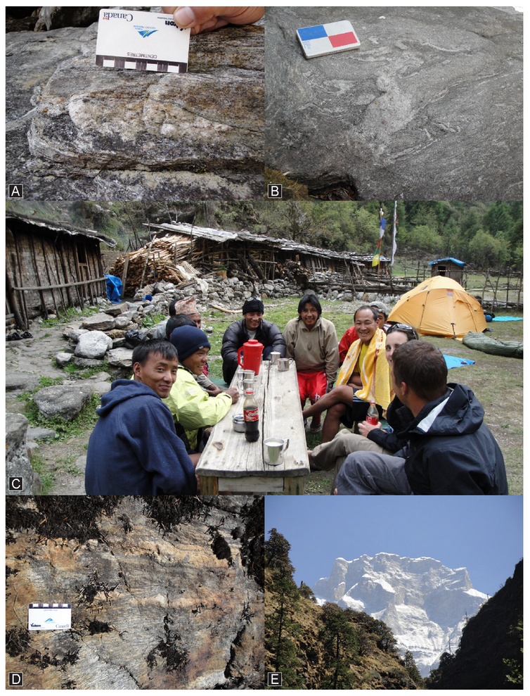
The destination for today is the riverside gathering of houses known locally as Dogang (or Dognag). There is a nice area that can be used for camping (Figure 11C) and a well-constructed outhouse for use by trekkers. If the river is low enough, it is possible to hop across the stones to examine the rocks on the far side; however, they are quite similar to those that have been examined for most of the day. Tomorrow the ascent up to the village of Bedding will commence, which, at an altitude of ~3600 m, is high enough for some to begin to feel the effects of high altitude. Be aware of the possible symptoms and treatment of altitude sickness.
Day Four
On day four the trail works its way ever higher and the hike ends above the main tree-line at the town of Bedding, a welcoming, well-organized, typical Sherpa village. One of the main sources of income for the families of Bedding is high-altitude guiding and carrying for climbing expeditions to the >8000 m peaks across Nepal. Bedding boasts the most Everest summiters per capita of any village in Nepal. While staying in Bedding it may be prudent to inquire about accommodation or camping in Na. Na is a seasonal village, used mainly during the hot months and for animal grazing. Depending on the timing of your trip there may be no place to stay if you show up in Na unannounced; it is best to check in Bedding first.
The path today begins along the river valley, which is filled with colluvium, resulting in long stretches between outcrops.
Stop 13 - Sillimanite migmatite – (N27.90391˚, E086.31406˚)
This first outcrop of the day exposes sillimanite-bearing migmatite with foliation parallel, deformed leucogranite (Figure 11D). The migmatite includes quartz + feldspar + muscovite + biotite ± sillimanite ± garnet, while the leucogranite lenses comprise quartz + feldspar + muscovite ± tourmaline ± sillimanite. Though the age relationship between the leucogranite lenses and the leucosome within the migmatite is not particularly clear, it appears that the leucogranite lenses are the younger phase, with the foliation of the migmatite wrapping around them (Figure 11D). Unlike the younger intrusive phase observed at stop 11, however, these leucogranite lenses appear to be concordant with the main tectonic foliation.
Just up the trail from this outcrop are some of the best views of Gauri Shankar, one of the highest peaks in the region at 7135 m, to the north (Figure 11E).
Stop 14 - Variable Psammitic Gneiss and Quartzite – (N27.90374˚, E086.33268˚)
The lithology at this point has changed from a metapelitic-dominated migmatite to a metapsammitic gneiss. This change is accompanied by a reduction in the amount of anatexite, or leucosome, within the rock. The rocks at this outcrop include quartzite, psammitic gneiss and paragneiss, all with varying degrees of migmatization (Figure 12A). The rocks nearby up the trail are similarly variable, however, the outcrops show some of the deformational structures within these units.
Figure 12. Field photographs from stop 14 and views at incoming weather

A) Variably migmatitic, metapsammitic gneiss. B) Folding (?) within quartzite. See text for discussion. C) Recumbent folding within migmatitic gneiss. Hammer is 36 cm long. D) View up the Rolwaling valley to the east. E) Yaks in the middle of a heavy snowfall in the village of Na. F) View down the Rolwaling valley (to the west) at incoming weather
One of these structures includes a possible fold within quartzite (Figure 12B). This may reflect evidence of drag folding along a minor shear within the unit, or perhaps deformed original cross bedding. In addition, a bit farther up the trail there is a reclined fold within intercalated metapsammite and more mica-rich paragneiss (Figure 12C). Although the individual fold limbs are at an angle to the main foliation attitude, the overall shape of the fold approaches isoclinal, with an axial plane parallel to the main foliation. The fold is indicative of deformation characterized by horizontal extension and vertical thinning.
Stop 15 - Variable Paragneiss and Leucogranite – (N27.90401˚, E086.34673˚)
The final stop of the day before reaching Bedding is at an outcrop that contains at least three distinct lithologies: 1) quartz + biotite metasandstone/quartzite; 2) quartz + biotite + muscovite + sillimanite + feldspar ± garnet migmatite; and 3) quartz + feldspar + biotite + sillimanite psammitic gneiss. The foliation in these rocks dips northeast, reflecting the rotation of the main foliation that is occurs along the Rolwaling.
Quartz lattice preferred orientation analysis of a quartz-rich specimen from this location reveals a c-axis fabric pattern dominated by prism [c] slip with lesser components of prism <a> (Figure 7C). The opening angle of the fabric indicates deformation temperatures exceeded 750 ˚C, suggesting deformation may have been coeval with near-peak metamorphism or at least occurred shortly thereafter.
Bedding
On the walk up the hill to Bedding you may have noticed float with ellipsoidal leucocratic nodules, presumably originating from the surrounding rock. These nodules are interpreted as faserkiesel; knots or pods of quartz + sillimanite ± muscovite ± K-feldspar. The formation of faserkiesel appears to be compositionally dependent and may reflect a former stable K-feldspar + sillimanite assemblage that has been subject to retrograde metamorphism involving paired ionic equilibria (Tippet, 1984). If that interpretation is correct it implies that the mineral assemblage preserved in the sillimanite grade rocks does not represent peak metamorphic conditions. More detailed phase equilibria modeling of these rocks is being carried out to investigate this possibility.
Day Five
Today is a short trek day necessitated by the climb in elevation to the destination of Na. There is much rock to examine along the way, though much of it crops out some distance off of the main trail. The landscape and minimal cover in the area makes it relatively easy to reach those outcrops.
It is worthwhile mentioning that you are now in an alpine environment in which the weather can change drastically and quickly (Figure 12D). One year on traverse we were caught in a four-day snowstorm (Figures 12E and F) and were forced to retreat back down to lower elevations through thigh-deep snow. Be prepared for any and all potential weather conditions.
Stop 16 – Quartzo-feldpathic gneiss – (N27.90411˚, E086.37676˚)
The first stop today is to look at the outcrops just above the town of Bedding. The rocks here are similar to the rocks examined towards the end of the Day 5 (yesterday), with abundant quartzo-feldspathic gneiss intercalated with more mica-rich layers. You will likely notice, on your walk up to the outcrop, that there is abundant float with large K-feldspar crystals; we will examine the source rocks tomorrow. Be sure to explore the outcrop as the lithology, structural style, and relationship between the country rock and leucogranite can vary locally. The main lithology appears to be a meta-sandstone (Figure 13A) that contains course-grained to pegmatitic quartz + feldspar + tourmaline ± muscovite leucogranite lenses. This leucogranite follows the foliation locally (Figure 13A), but is also seen cutting across the foliation at a high angle (Figure 13B) indicating it may be late syn-to-post kinematic.
Isoclinal folding (Figure 13C) similar to that observed below indicates horizontal stretching and vertical thinning – style deformation.
Figure 13. Field photographs from stops 16 and 18
A) Metasandstone paragneiss with abundant luecogranite lenses. B) Leucogranite dyke cross-cutting the dominant tectonic foliation. Hammer is 36 cm long. C) Recumbent folding within migmatitic gneiss. Orthogneiss with layer parallel leucosome (D) and local porphyroclasts of potentially disaggregated leucosome (E).
Stop 17 – Migmatitic Quartzo-feldspathic gneiss – (N27.89985˚, E086.38164˚)
The rocks at this stop show the same relationship to those observed above Bedding. The main lithology exposed is quartzo-feldspathic gneiss, perhaps a meta-sandstone, with layer-parallel leucosome and melanosome. The rock is cut by later, discordant, coarse-grained to pegmatitic leucogranite pods. Again, isoclinal folding of the foliation is common, with the fold axial plane parallel to the dominant foliation.
Stop 18 –Orthogneiss contact – (N27.88344˚, E086.40418˚)
This is the approximate location of the contact between the quartzo-feldspathic paragneiss (meta-sandstone) and the structurally overlying granitic orthogneiss. Structurally higher the rocks comprise migmatitic orthogneiss in which disaggregated leucosome, or perhaps synkinematic injected dykes and/or sills, now form both foliation parallel layers (Figure 13D) and local porphyroclasts (Figure 13E). The orthogneiss consists of feldspar + quartz + biotite, while the leucogranite comprises feldspar + quartz + tourmaline ± muscovite. While this location represents the approximate transition between the different units, the orthogneiss observed here it not particularly typical of the majority of that unit that we will examine in future stops.
Na
The village of Na is a well-constructed labyrinth of stone fences and stone houses. It serves as the grazing land and summer home for many of the families in Bedding. Na sits at an elevation of ~ 4200 m and as such it is not a bad idea to have a rest or break here to help acclimatize to the altitude. Na will serve as the base for the next day of the field trip, which will be spent exploring farther up the valley before returning to the village at the end of the day.
Day Six
Today will be spent exploring a region up the valley east of Na leading to the foot of Tso Rolpa, one of the largest glacial lakes in the world. Tso Rolpa is continuously monitored for potential glacial lake outburst floods (GLOFs); or at least monitoring equipment was installed. The aim of the monitoring program is to notify villagers in Bedding to move to higher ground should a flood occur.
Stop 19 – Augen Orthogneiss - (N27.87855˚, E086.43808˚)
At this location the orthogneiss is distinctively augen-rich; the K-feldspar augen range from 1-2 cm in diameter to >10 cm in diameter. The rock is pervasively deformed and on fresh surfaces the asymmetry of the fabric elements can be investigated to determine the shear sense recorded. It can be difficult, however, to determine the orientation of the stretching lineation and the appropriate observation surface for shear indicators.
Though not immediately apparent in outcrop the orthogneiss is intruded by leucocratic dykes. These dykes can be observed in the cliff face above the outcrop (Figure 14A).
If you continue on from this outcrop to the east and make your way up to the top of the talus cone, there is an excellent washed exposure of the augen orthogneiss near a small waterfall (Figure 14B). The outcrop here provides a three dimensional view of the augen and the potential asymmetry they demonstrate. Notably absent in this washed exposure is evidence of any intrusive rocks similar to those noted in the cliff face.
Figure 14. Field photographs of leucogranite dykes, orthogneiss and paragneiss
A) Leucogranite dykes (light diagonal streaks) visible in a cliff face above Na. B) Orthogneiss with large K-feldspar augen. C) Leucogranite dyke (recessive) cutting across the dominant tectonic foliation (from Larson, 2012; book is 11 cm across). D) Well-foliated paragneiss at high structural levels above the village of Na. E) Leucogranite dykes cutting across paragneiss (hammer is 36 cm long). F) Coarse-grained leucogranite dyke crosscutting augen othrogneiss.
Stop 20 – Intruded Metasedimentary Rocks – (N27.87843˚, E086.44570˚)
This location is structurally above the main orthogneiss unit, in a migmatitic quartzo-feldspathic gneiss with foliation-parallel leucosome. The leucosome is locally prone to recessive weathering giving the outcrop a pitted or rough appearance. The country rocks are cross-cut by a series of leucogranite dykes (Figure 14C) of variable thickness. The dykes themselves weather more readily than the rocks they intrude, making them fairly conspicuous. The same relationship between leucogranite dykes and rocks at a similar structural level is observed in the upper Tama Kosi valley (Larson, 2012). Preliminary monazite and xenotime ages from the main intrusive phase above the dykes at the structurally highest level in the region indicate that it is Early Miocene in age (J. Cottle pers. comm.). The dykes noted in the previous study (Larson, 2012) and those noted here have the same mineral content as the main plutonic body and as such are likely part of the same intrusive event. If so, that would imply that deformation and development of the foliation in this region occurred prior to the Early Miocene.
Stop 21 – Metasedimentary Rocks – (N27.87796˚, E086.45030˚)
This stop is just a bit farther along the cliff-side to the east. Here a very similar metasedimentary assemblage is preserved, with well-defined layering (Figure 14D), perhaps reflecting transposed primary compositional variation. Thin granitic dykes are also observed at this location and cross-cut the dominant foliation at a high angle (Figure 14E).
Stop 22 – Cross-cut Augen Orthogneiss – (N27.87124˚, E086.44103˚)
For the final stop of this field trip we cross to the other side of the valley and part way up the trail leading to Yalung La. Here we have moved structurally below the metasedimentary rocks of the past few stops and back into the augen orthogneiss unit. A unique aspect of this outcrop, however, is that the orthogneiss is cut by course-grained feldspar + quartz + tourmaline ± muscovite leucogranite dykes (Figure 14F). These dykes are similar in character to those observed structurally higher and, if the interpretation of the age of those dykes is correct, then it implies that the ductile deformation within the orthogneiss must predate the Early Miocene as well. Further work to more tightly constrain the timing of deformation in this region is underway.
Na
It is suggested that the night be spent in Na once again. After a day of hiking around at high altitude the body will be glad for a rest before beginning the return trip. There is much to explore around the upper portion of the Rolwaling valley and many beautiful views to be seen. The steep valley walls also perform an admirable job of auto-sampling otherwise unreachable outcrops, bringing boulders to more accessible elevations. Moreover, this is an opportunity to examine Tso Rolpa and the engineering efforts that have been made to monitor and manage the lake.