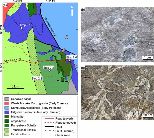
Day 2
The second day begins with a long drive south along the high altitude New England highway (~1000 m a.s.l), via the town of Glen Innes (Figure 3). The majority of the outcrops between Tenterfield and Glen Innes are late Permian to Triassic I-type granitoids and volcanic rocks. South of Glen Innes the dominant rocks are Cenozoic basalts.
Stop 2.1. Tobermory Monzogranite
GPS coordinates: -30.196364°/152.010624°
Distance from Tenterfield: 172 km
The Tobermory Monzogranite is part of the Hillgrove Plutonic Suite, which is made of early Permian S-type granitoids. A recent U-Pb SHRIMP zircon age from this pluton (from a locality ~2 km north of this stop) has yielded an age of 292.4±2.9 Ma (Rosenbaum et al., 2012).
The rock is deformed with a steeply dipping fabric striking NW-SE. This orientation is parallel to a sharp linear morphology expressed as a valley, which can be followed for a distance of ~3.5 km (Figure 5a). Elsewhere in the pluton, deformation is much weaker, suggesting that the fabric recognised here is related to a localised shear zone.
Regionally, the Tobermory Monzogranite is part of a series of plutons of similar age, which form a N-S belt of S-type granitoids (Figure 1b). This belt is supposedly situated in the eastern limb of the Manning Orocline, while the western limb is represented by the Bundarra Granite (Rosenbaum, 2012). Our recent geochronological ages confirm the suggestion that these granitic plutons were emplaced simultaneously (Rosenbaum et al., 2012). However, the nature and geochemistry of magmatism is somewhat different, with the Bundarra Granite being more voluminous, coarse-grained and richer in SiO2 (Shaw and Flood, 1981).
Stop 2.2. Girrakool beds (transitional schists)
GPS coordinates: -30.320311°/152.065682°
Distance from previous stop: 19 km
The early Permian S-type Hillgrove plutons, such as the Tobermory Monzogranite visited in the previous stop, were intruded into Carboniferous metasedimentary rocks of the Tablelands Complex, which are here represented by the Girrakool beds. The rocks were deposited in a subduction complex, and metamorphosed under variable metamorphic conditions. As we move eastward in the next few stops (stop 2.2 to stop 2.5), we will see a progressive increase in the metamorphic grade, from the very low grade Girrakool beds in this locality, to high-grade amphibolite-facies rocks and migmatites (Figure 5a). This metamorphic complex is normally referred as the Wongwibinda metamorphic complex (Binns, 1966; Stephenson and Hensel, 1982; Danis et al., 2010; Craven et al., 2012).
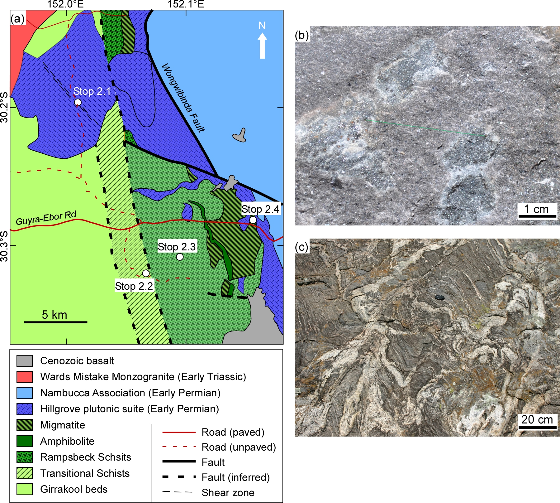
Figure 5. Geology of the Wongwibinda metamorphic complex.
(a) Geological map of the Wongwibinda metamorphic complex (modified after Danis et al., 2010). (b) Large cordierite poikiloblasts in the Rampsbeck schists (Stop 2.3) (photo courtesy of Steve Craven); (c) Partial melting and folding in migmatites (Stop 2.4) (photo courtesy of Nathan Daczko).
The Girrakool beds in this locality are low-grade metamudstones and greywackes, located at the western margin of the metamorphic complex. The mudstones have been reconstituted to phyllites containing quartz, plagioclase, biotite, muscovite and minor graphite. The greywackes have large size clasts of primary sedimentary quartz and feldspar in a recrystallised matrix. Bedding and graded bedding are preserved. The rocks are moderately deformed with slaty cleavage developed, especially in the mudstone. Refraction of the structural fabric can be recognised, and most likely reflect primary graded bedding. Steeply plunging folds are also recognised.
Stop 2.3. Rampsbeck schists
GPS coordinates -30.308807°/152.093561°
Distance from previous stop: 4.3 km
Access to this outcrop involves walking northward from Lynoch driveway for a distance of 1.6 km and requires permission from the property owners. The protolith of these rocks is considered to be the Girrakool beds, but in this locality the sedimentary grains are completely recrystallised to a biotite-quartz-plagioclase schist with large (up to 2 cm) poikiloblasts of cordierite, k-feldspar and muscovite ± garnet (Figure 5b). Inclusions within poikiloblasts are randomly oriented and dominated by biotite and quartz. Geothermobarometry analysis on the assemblage grt-bt-plag-kfs-qtz yielded pressure-temperature estimates of 0.42±0.12 GPa and 647±36°C (Danis et al., 2010).
Stop 2.4. Migmatites
GPS coordinates: -30.281746°/152.155289°
Distance from previous stop: 19.5 km
At this locality, we are situated in the highest-grade of the metamorphic complex, with rocks exhibiting amphibolite-facies conditions and migmatisation (Figure 5c). The migmatites comprise quartz, biotite, plagioclase, microcline and garnet ± cordierite and are characterised by abundant melanosome layers and folded leucosomes (Danis et al., 2010). The directly calibrated pressure-temperature estimates have relatively large error bars (0.46±0.45 GPa and 764±106°C, Danis et al., 2010), but demonstrate increasing temperature conditions relative to the Rampsbeck schists. Pseudosections from high-grade rocks indicate temperatures of ~660°C and pressures of <0.35 GPa (Craven et al., 2012).
Close to this locality, the high-temperature metamorphic rocks have been intruded by another pluton of the Hillgrove suite, the Abroi Granodiorite. Recent geochronological data by Craven et al. (2012) (U–Th–Pb monazite age) shows that peak metamorphism occurred at 296.8±1.5 Ma, which is ~6-7 Ma prior to the emplacement of Abroi Granodiorite (~290 Ma, Cawood et al., 2011a; Craven et al., 2012). These results indicate that it is not the local heating associated with magmatism that was responsible for high-temperature metamorphism. On the contrary, S-type magmatism occurred after peak metamorphism, and was most likely associated with melting of the subduction complex rocks. The observations from the Wongwibinda metamorphic complex, together with time constraints on the emplacement of S-type granitoids, indicate that during the early Permian (300-290 Ma), these rocks were situated in an anomalously hot tectonic setting. In the context of a convergent margin, this tectonic environment would most likely be the backarc region, which is typically characterised by anomalously high heat flow (e.g. Hyndman et al., 2005). The coincidence of regional high-temperature metamorphism, crustal melting, bimodal volcanism and the development of rift-related sedimentary basins (Korsch et al., 2009, and Stop 3.1) supports the idea that early Permian tectonics in the New England Orogen was primarily controlled by backarc extension.
Stop 2.5. Ebor Falls
GPS coordinates: -30.403008°/152.342914°
Distance from previous stop: 29.5 km
After crossing the Wongwibinda Fault (5a), we travel east through low-grade metasedimentary rocks, before entering into a large area covered by Cenozoic basalts.
The spectacular Ebor Falls exposes a thick section of basaltic lava flow, overlying early Permian metasedimentary rocks of the Nambucca Association. Structurally, we are located in the southern continuation of a large N-S trending strike-slip fault, the Demon Fault (Figure 1b). Farther north, the Demon Fault has a clear geological and morphological expression for approximately 150 km, but in this area and farther south it becomes less clear. The Demon Fault has a post-Triassic dextral strike-slip movement of 25-30 km (McPhie and Fergusson, 1983).
The basalts are part of a central volcano (Ebor Volcano) dated at 19-20 Ma (Ashley et al., 1995). The lava flow has a substantial thickness of up to 400 m and covers an area of 480 km2. Rocks are mostly olivine- and quartz-normative tholeiitic basalts, with some variations to alkaline and transitional basalts (Ashley et al., 1995).
The Ebor Volcano is one in a series of Oligocene to Miocene central volcanoes in eastern Australia. These volcanoes become progressively younger from north to south, suggesting that they correspond to a hotspot track above a fixed mantle plume. The motion path of the Australian plate relative to this hotspot has recently been unravelled by 40Ar/39Ar geochronology of the central volcanoes (Knesel et al., 2008), showing a pronounced deceleration in the motion of Australia at 26-23 Ma.
Stop 2.6. Newell Falls - Dorrigo Mountain Complex
GPS coordinates: -30.393299°/152.745943°
Distance from previous stop: 56 km
The winding road from Ebor Falls descends eastward through Cenozoic basalts, before reaching the underlying early Permian rocks. The Dorrigo Mountain Complex is a heterogeneous igneous body comprising fine-grained diorite and granite, which seems to intrude the basal layers of the early Permian Nambucca succession. Recent SHRIMP U-Pb zircon dating from this locality yielded an age of 295.5±3.0 Ma (Rosenbaum et al., 2012).
The igneous complex is one in a series of early Permian plutons that occur along a NW-SE belt between Glen Innes and Coffs Harbour (Figure 1b). This belt is the eastern continuation of the Hillgrove plutonic suite farther west, with both segments emplaced simultaneously at 295-290 Ma (Rosenbaum et al., 2012). The granitic belt is curved around the area of the Henry River Granite (Figure 1b), thus defining another strong bend in the structural grain of the southern New England Orogen. This bend, referred to by Rosenbaum et al. (2012) as the Nambucca Orocline, could be the internal hinge of the Texas Orocline (Figure 2b). Farther to the southeast, the orocline is represented by the Hastings Orocline (Glen and Roberts, 2012).
Travelling east from this locality, the narrow road continues to meander through a lush rainforest. The rocks immediately adjacent to the Dorrigo Mountain Complex, the McGraths Hump basalts, are early Permian in age, and are possibly part of the same igneous complex. These rocks are equivalent in age and nature to other bimodal volcanic rocks within the early Permian Nambucca Block, such as the Petroi Basalt (Asthana and Leitch, 1985) and Halls Creek Volcanics (Leitch, 1988; Cawood et al., 2011a). The age of the latter has recently been dated as 292.6±2.0 (Cawood et al., 2011a). The importance of these rocks is that they all occur close to the base of the early Permian sedimentary succession of the Nambucca Block, and therefore provide an age constraints for basin development. The collective observations on bimodal volcanism, high-temperature metamorphism (Stops 2.4 and 2.5), crustal melting (Stop 2.1) and rift-related sedimentation (Stop 3.1), further support a backarc extensional environment during the early Permian.
The second day concludes in the coastal town of Nambucca Heads, 57 km from the last stop.