Geological background
The New England Orogen is the most easterly of the five orogenic belts and an internal foreland basin system that constitute the Tasmanides of eastern Australia (eg. Cawood 2005; Glen 2005) (Fig. 1a). Late Devonian to end Carboniferous rocks of the New England Orogen of eastern Australian accumulated in a convergent margin orogen that comprises a western continental margin arc, a central forearc basin and an eastern subduction complex (eg. Scheibner 1973; Leitch 1975; Cawood 2005; Glen 2005) (Fig. 1b). These elements can be followed for ~2000 km from Townsville in north Queensland southwards to Newcastle in NSW. This paper only discusses the NSW part. In NSW, these elements were built upon older Cambrian to Ordovician supra-subduction zone elements in the south, older continental crust in the west and older Silurian-Middle Devonian accreted arcs (Cawood and Leitch 1985; Aitchison and Flood 1995; Glen 2005). Indirect evidence suggests the southern New England Orogen is also partly built on Neoproterozoic continental crust (Glen 2005; Glen submitted) that is the source for some zircons in granites (Shaw et al. 2011). Cambrian and Ordovician supra-subduction zone elements are preserved largely as blocks in a serpentinite matrix melange within the major Peel-Manning Fault System (see Fig. 1b, c), in fault blocks to the west, and in coastal outcrops at Port Macquarie (Fig. 1b) (eg. Glen 2005).
Western arc
The presence of the western Late Devonian intermediate (andesitic) Baldwin arc and the overlying Carboniferous largely felsic arc Currububula arc (Veevers et al. 1982; McPhie 1987) is inferred from the nature of detritus in the forearc basin to the east (eg. Korsch 1984). Interpretation of seismic data (see below) suggests the arc might lie at depths between 3 and 7 km, beneath overthrust rocks of the forearc basin. The eastern fringe of the Late Devonian arc is approximated by large olistoliths of andesitic volcanics in the north of the Tamworth belt (Brown 1987). The eastern fringe of the Carboniferous arc is approximated by Carboniferous rhyolite to rhyodacitic, rarely andesitic, ignimbrites, with rare intrusive dacites, along the curvilinear western and southern margins of the Tamworth belt (eg. Roberts et al. 2003). Up to 1200 m of the felsic (rarely intermediate) Nerong Volcanics at Port Stephens (located in Fig.1b) reflect a volcanic centre (Buck 1986; 1988; Roberts et al. 1991). No arc is recorded from the southern New England Orogen in the early Permian, but subduction-related magmatism in the Gympie arc in Queensland is early Permian in age (Sivell and Mcculloch 2001). Late Permian–Triassic, granites of the Clarence River Supersuite represent the roots of a continental margin arc (Bryant et al. 1997) that intruded older subduction complex rocks, reflecting either steepening or rollback of the subduction zone plate boundary (Jenkins et al. 2002) or by upper crustal transport (Cawood et al. 2011b).
Petroleum exploration east of Sydney has identified undated volcanic and volcaniclastic rocks that define the Offshore Uplift (Grybowski 1992; Bradley 1993; Alder et al. 1998; Bounty Oil and Gas NL 2002; Breeze 2009) (Figs. 1b) (see later). Breeze (2009) suggested these volcanic rocks are progressively overlain by Permian to Cainozoic strata, and aeromagnetic data indicate continuity and similarity with the Carboniferous arc (Nerong Volcanics) at Port Stephens (Fig. 1b).
The forearc basin
The forearc basin is called the Yarrol trough in Queensland and the Tamworth trough in the southern New England Orogen, in NSW, where it is better known as a fold-thrust belt called the Tamworth belt (Fig. 1b). The Tamworth belt swings in strike from NNW in the north to E in the south, and outlines a broad, south-closing fold (Fig. 1b). The western and southern boundaries of the forearc basin are separated from the Permian Gunnedah-Sydney foreland basin system to the west by the Mooki Thrust in the north and the Hunter Thrust in the south, separated by the latitudinal Murrurundi Fault (Fig. 1b). The Mooki Thrust disappears under Mesozoic cover at its northern end, passing northwards into a series of meridional thrusts (Goondiwindi, Kelvin, Tingan and Moonie) that can be recognised in seismic data as the thrusted western margin of the Tamworth belt (Korsch et al. 2009).
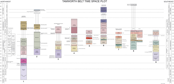
The eastern and northern parts of the forearc basin comprise Late Devonian volcaniclastic strata built upon the accreted Silurian-Devonian Gamilaroi arc (Tamworth Group, Aitchison and Flood 1995), and Cambrian and Ordovician blocks (Cawood and Leitch 1985) that flank the western side of Peel-Manning Fault System. The western and southern parts of the forearc basin consist of Carboniferous strata interrupted by Devonian rocks in a major hangingwall anticline in the northwest, and overlain by early Permian strata in a few key synclines. Major facies changes along the length of the basin have produced a proliferation of stratigraphic names that complicate correlations. Our time-space plot (Fig. 2) shows correlations based on palaeontology and SHRIMP dating of ignimbrites (Roberts et al. 1991, 2003, 2004, 2006) and is used as a basis for later discussions.
Figure 2. Time-space plot showing stratigraphic correlations in the southern part of the Tamworth Belt.

From Roberts and Glen (2010), based on Roberts et al. (2003, 2004, 2006). Numbered sections are located in Figure 3.
Repetitions of the forearc basin and its basement around the Texas orocline occur near the NSW/Queensland border as the Emu Creek Formation (Scheibner 1976), Mount Barney Beds (Olgers et al. 1974) and the Silverwood Group (van Noord 1999) respectively (Fig. 1b). Several early workers (Scheibner 1976; Leitch 1980; Cawood 1982) suggested that the Hastings Block formed as part of the forearc basin, and was structurally out of place. Its origin, as a fold repeat of the forearc basin (Fig. 1b) is discussed further below.
Subduction complex rocks
Subduction complex rocks are separated from the forearc basin by the Peel-Manning Fault System (Leitch 1974) (Figs. 1b, 1c), which contains Cambrian and Ordovician igneous and meta-igneous blocks in a serpentinite matrix melange that was only emplaced by the early Permian (Allan and Leitch 1990). Ages range from Silurian in west to Carboniferous in the east and south. Descriptions have been given by Cawood and Leitch (1985), Aitchison et al. (1992), and have been summarised by Glen (2005) and Cawood (2005).
Permian units
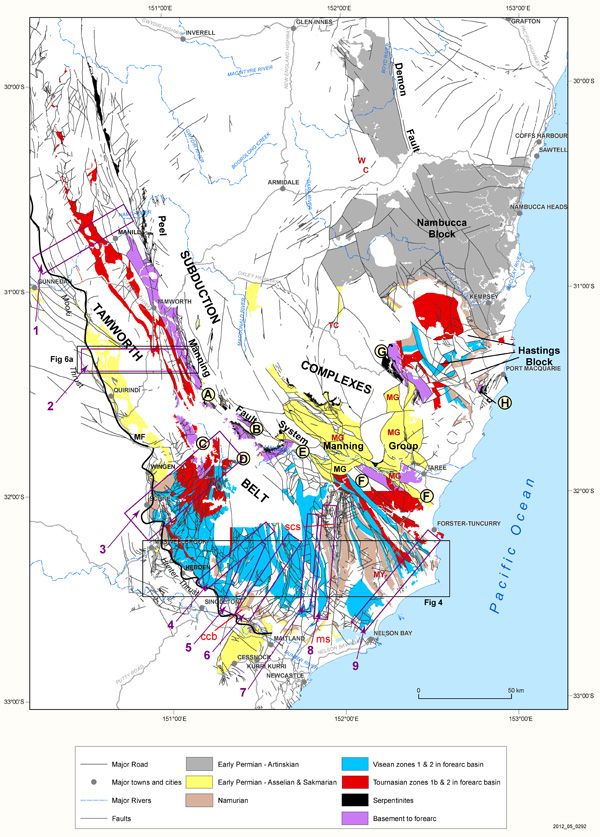
Permian rocks of the southern New England Orogen occur in four different settings (Fig. 3): i) early and middle Permian volcanic and sedimentary units in synclines above forearc basin rocks, such as in the Stroud-Gloucester, Myall and Medowie synclines, the cranky Corner Basin and above the Mooki Thrust north of Wingen (Figs 3, 4). Early Permian volcanic rocks (Alum Mountain Volcanics) are mafic to felsic with enriched-MORB-type chemistry (Jenkins et al. 2002) and are dated as Asselian in age (Roberts et al. 1991); ii) the early Permian Manning Group southwest of the Hastings Block (Figs. 3, 5). These clastic strata, commonly with chert clasts derived from uplift of the subduction complex, are in fault contact with the subduction complex; and iii) shallow water early Permian (Asselian and Sakmarian) rocks around the northern margin of the Hastings Block (Figs. 1b, 3, 5) that deepen northwards (across faults) into iv), mainly Artinskian turbiditic strata of the Nambucca Block and region to the east (Fig. 3). Volcanic rocks in the Nambucca Block include the felsic, Sakmarian Halls Peak Volcanics (SHRIMP age of 292.6 ± 2 Ma, Cawood et al. 2011a), and early Permian basalts – the alkali within-plate-Petroi Metabasalt (Asthana and Leitch 1985) and the ocean floor tholeiitic MORB-type (McGraths Hump Metabasalt, Scheibner and Pearce 1978; Leitch and Asthana 1985). It is still uncertain whether ii) and iv) are relics of a single large basin (Leitch 1988) or formed as separate basins, either of rift or transtensional origin (eg. Atchison and Flood, 1992).
West of the New England Orogen, early to late Permian strata occur in the Sydney and Gunnedah basins (Fig. 1b). Although mainly yoked to the New England Orogen, they were initiated as rift basins with mafic and felsic volcanics (eg. Rylstone, Werrie, Boggabri volcanics and in the Dalwood Group) that still show some relic supra-subduction zone component in the melt (Jenkins et al. 2002).
Figure 3. Chronostratigraphic elements of the forearc basin

Geology of forearc basin showing the distribution of key chronostratigraphic horizons, together with its basement and Early Permian cover. Note that the Tournasian zones are over-emphasised in the Hastings Block, as are the Visean zones just north of Nelson Bay. Abbreviations: ccb=Cranky Corner Basin; MG=Manning Group; ms=Medowie Syncline; my=Myall Syncline; scs=Stroud-Gloucester Syncline; tc=Tia complex; wc=Wongwibinda complex. Letters refer to localities mentioned in text. Boxes refer to approximate locations of stratigraphic sections 1-9 in Figure 2.
Granites
Much of the area occupied by subduction complex rocks has been intruded by granites. The oldest event (300 to 285 or 280 Ma, Cawood et al. 2011b; Rosenbaum et al. 2012) comprises plutons of the S-type, undeformed Bundarra Supersuite (~292-288 Ma) and of the S-type deformed Hillgrove Supersuite (~296-288 Ma). The oldest granite of the I-type Clarence River Supersuite, the Kaloe Granodiorite, was also emplaced in this intervaal at 291.9 ± 2 Ma (Cawood et al. 2011b). These granites provide a minimum age for early deformation of the subduction complex and were deformed by oroclinal folding (Cawood et al. 2011a; Rosenbaum et al. 2012). Younger granites range in age from late Permian to Early Triassic (255-244 Ma, Bryant and Chappell 2010). They are I-types, constitute the New England Batholith that cuts across oroclinal folds (eg. Cawood et al. 2011b figure 2) and are coeval with large volumes of latest Permian I-type volcanic rocks (eg. Brownlow and Cross 2010). The youngest granites, which occur near the coast, are 235-212 Ma in age and are I and A-type in composition (Shaw and Flood 1991; Bryant and Chappell 2010; Blevin 2010). They intrude and mask the southeastern parts of the Hastings Block (see later). The main hiatus in granite magmatism lasted from ~280 to ~260 Ma (except for the 267 Ma Barrington Tops Granite, Rosenbaum et al. 2012; Cawood et al. 2011b).