Third phase: regional-scale geoarchaeology from 2000 to the present
By the advent of the 21st century geoarchaeology had acquired a strong hold on archaeological field applications in Greece, a development that came along with an ever-increasing apprehension of its scientific importance by the Greek academic community. Especially in prehistoric archaeology and starting already during the 1980s and 1990s, there has been a growing shift in the research paradigm towards regional surveys and land-use studies, which focus on the examination of regional settlement patterns (Runnels 2003). While intensive regional surveys were being carried out in parallel and complementary to local excavations (e.g. Bailey 1997), novel site detection techniques and the interpretation of regional distribution patterns called for a closer cooperation between archaeologists and their colleagues from the earth sciences.
Accordingly, geoarchaeological research continues in this phase to be oriented mainly towards palaeoenvironmental and palaeogeographic reconstructions and the understanding of past socio-cultural developments within a broader framework of geomorphological, ecological and paleoclimatic processes. While some studies serve to provide a diachronic or inter-regional account of palaeoenvironmental changes with regard to important archaeological sites (e.g. Lespez et al. 2004; Triantaphyllou et al. 2010; Vouvalidis et al. 2010), other works apply and test novel computer-based techniques that are integrated into multi-method approaches for the reconstruction of macro-topographic changes (e.g. Alexakis et al. 2011). In addition, several investigations aim at testing specific claims put forth by historians and archaeologists or assumptions raised by ancient literary sources, such as those of Herodotus, Homer or Strabo. This is, for example, the case with the search for the location of Homer’s ancient Ithaca (Underhill 2009); the examination of the position and nature of the port of Oeniades (Fouache et al. 2005) and the harbor of ancient Corinth (Morharge et al. 2012), or the insular character of Piraeus in late prehistoric times (Goiran et al. 2011); and the investigation of the shoreline displacements and the evolution of the landscape in today’s plain of Thessaloniki, around the ancient city of Pella or in the vicinity of other specific archaeological monuments (Ghilardi et al. 2008, 2010).
As expected, the new studies elaborate on, reexamine and sometimes challenge research carried out in the previous decades. Thus, in the frames of the Nikopolis Survey Project (Wiseman and Zachos 2003), Runnels and van Andel (2003; van Andel and Runnels 2005) revisited some major open-air Palaeolithic sites associated with the poljes of north-west Greece (the so-called ‘red-bed’ sites of Epirus) and discovered new Palaeolithic and Mesolithic sites. Their work furnished a regional chronostratigraphic scheme for the Palaeolithic sites of Epirus based on combined paleosol and TL/IRSL-dated stratigraphy (see also Zhou et al. 2000), presenting at the same time a model for the tecto-sedimentary evolution of the karst landscape, reconstructions of Quaternary paleoshorelines, grain-size and mineral composition of archaeological sedimentary contexts, as well as a discussion about the way in which Palaeolithic stone-tools may have been incorporated into the terra rossa matrix. This research built critically upon earlier geoarchaeological studies of the depositional environments of Palaeolithic artefacts (e.g. Bailey et al. 1992) and especially terra rossa and paleosols as archaeological contexts (van Andel 1998; Pope et al. 1984); but also continued on and juxtaposed its results to a thread of research on the tectonic and geographic background of the Quaternary landscapes of Epirus and the ways in which tectonic movements or topographic configuration may have influenced Palaeolithic land-use strategies and/or archaeological preservation (King and Bailey 1985; Sturdy and Webley 1988; Bailey et al. 1993; King et al. 1997; Sturdy et al. 1997).
Geoarchaeological research in Greece never lost its ‘costal focus’ and, after the first pioneering works that appeared in the 1970s and 1980s, coastal geoarchaeology carried on in the nineties (e.g. Niemi 1990; Zangger 1991; Mourtzas and Marinos 1994). In fact, as it becomes evident by the sheer number and quality of publications that have appeared in the last dozen of years, geoarchaeological applications have uninterruptedly, widely and successfully been used to solve archaeological problems or to reconstruct the environmental settings of coastal archaeological sites (e.g. Jing and Rapp 2003; Kraft et al. 2005; Vott et al. 2006; Pavlopoulos et al. 2006; Bruins et al. 2008; Vott et al. 2008; Shaw et al. 2008; Kapsimalis et al. 2009; Pavlopoulos et al. 2010; Athanassas et al. 2012; Mourtzas 2012; Pavlopoulos et al. 2012; Ferentinos et al. 2012; Ghilardi et al. 2013). Most of these works were largely based on and/or benefited from geological and geomorphological research on coastal paleogeography and sea-level fluctuations (e.g. van Andel et al. 1990b; Lambeck 1996; Perissoratis and Conispoliatis 2003; Pirazzoli 2005; Evelpidou et al. 2012), as well as sedimentological and stratigraphic studies of the continental shelf or of marine basins, gulfs and river deltas (e.g. Collins et al. 1981; Cramp et al. 1988; Perissoratis and Mitropoulos 1989; Mascle and Martin 1990; Roussakis et al. 2004; Kapsimalis et al. 2005; Lykousis et al. 1995, 2005; van Andel and Perissoratis 2006; Papanikolaou et al. 2007; Poulos 2009; Lykousis 2009).
In a similar manner, research on human-environment interactions and on the relative contributions of climate- or human-induced processes as factors of landscape change remains a common target for geoarchaeologists working in Greece (e.g. Pope et al. 2003; Bintliff 2005; Bintliff et al. 2006; Fuchs 2007; Berger and Guillaine 2009). Although research on Holocene erosion in Greece continues to provide evidence for some degree of correlation between erosional episodes and cultural rather than natural processes (e.g. Fuchs 2007), there is at the same time a Mediterranean-wide growing awareness of the driving role that climate, tectonics and geology acquire in preconditioning human-induced erosion (Allen 2001; Casana 2008; Thornes 2009). Importantly, what seems to progressively gain attention in explaining past landscape changes, is the significance of short-lived, natural extreme events that can be related to recurrent but non-linear climatic episodes, bringing torrential rains and/or dramatic reductions in vegetation cover (e.g. Thornes cited in Bintliff 2002); or to tectonism (Gaki-Papanastasiou and Maroukian 1995; Maroukian et al. 2004; and also Zangger 1994, for a flash flood at Bronze Age Tiryns possibly associated with an earthquake). On the other hand, even though anthropogenic causation is still favored in many interpretations of alluvial aggradation (e.g. Lezpez 2003) and no less in pollen-based investigations (e.g. Jahns 2005; Kouli et al. 2009), a better understanding of Holocene climatic variability and the synchronicity of some fluctuations in the Mediterranean (Jalut et al. 2009), re-entered climate as a key-player and forced researchers to accept a mutual feedback between climatic triggering and anthropogenic disturbance (cf. Bintliff 2002). In a different but relevant line of research, Drake (2012) discusses how climatic stress –in the form of unusually arid conditions affecting agricultural productivity– might have contributed to the demise of Late Bronze Age societies, eventually leading to population decline and the collapse of the Greek Minoan and Mycenaean centers and palatial civilizations; in this work, the ‘climatic explanation’ for the dramatic changes seen in settlement patterns between the Late Helladic and the ‘Greek Dark Ages’ is tested against a number of climate proxies, including isotopes from speleothem records, pollen data, sea-surface temperatures, solar irradiance data and paleotemperature proxies derived from ice-cores.
As a whole, research carried out in Greece during the last two decades and centered on what could be considered as regional or landscape-scale geoarchaeology has profoundly contributed to a reconsideration of the role of the landscape in our understanding of past human behavior. The landscape was for long implicitly conceived more or less as a static, ‘inexorable’ background that needs to be solely reconstructed in order to become the setting for the archaeological narrative. Even in a slow-paced fashion, this view is being in recent times progressively abandoned in favor of more holistic and integrated approaches of landscape evolution in the archaeological reasoning. Evidently, such a development is rooted to concomitant advances in the theoretical and methodological armory of geoarchaeology, but it also echoes a deeper apprehension of the inherent complexities that become apparent when assessing natural and cultural environments and processes in conjunction. It is now, for instance, well-established that, due to their threshold-dominated nature (Schumm 1979; Vanderkerckhove et al. 2000; Bloom 2002), geomorphic systems are characteristically non-linear, exhibiting complex behaviors, controlled by dynamic instability and deterministic chaos (Thornes 1985; Phillips 1993); under such conditions, small and short-lived disturbances or changes to the initial conditions may result in disproportionately large and long-lived effects (Phillips 2006).
It is in this kind of geoscience rubric that a recent fieldwork-based, geoarchaeological approach of the Lower Palaeolithic record of Greece set out to explain the status of this record and outline the prospects of its future enrichment from a geomorphological perspective, by conducting a landscape-scale analysis and assessing preservation potential in juxtaposition to archaeological visibility (Tourloukis 2010). The central archaeological question here was straightforward and yet tricky: considering the paleontological, paleoanthropological, biogeographical and paleoecological status of Greece in the Quaternary, it has for long been expected that the Greek peninsula should produce valuable evidence for the earliest occupation of Europe; however, its early Pleistocene archaeological record stands out as a conspicuous ‘gap’ amidst the rich records of the circum-Mediterranean region. The fact that a large portion of this scanty evidence lacks a stratigraphic context and/or is associated with secondary (reworked) contexts emerges as a wider pattern that cannot be attributed to inappropriate research designs, the intensity of investigations or a lack of specialists in the field. Then, should this general ‘absence of evidence’ be ultimately regarded as ‘evidence of absence’ of hominins? The remains of hominin activities are likely to have been preserved, accessible/visible and stratified until the present only in areas where the relevant geological record is equally complete enough and has remained largely undisturbed. Disturbance versus preservation, erosion versus deposition, and deposition/preservation versus archaeological visibility/accessibility, are all conditioned mainly by geomorphic factors. These factors and their potentially biasing effects upon the archaeological record are tightly interrelated, but were examined as separate as possible, into four major groupings: climate, tectonism, sea-level changes and surface (slope) processes. A basic premise in this examination was the consideration of artefacts as another form of clastic material, because their hydromechanic, taphonomic and trasportational behavior does not differ from that of geological clasts (cf. Rick 1976; Schick 1987; Fanning and Holdaway 2001). Triggered either by climatic (e.g. deluges), tectonic (e.g. earthquakes) or anthropogenic processes (e.g. land use), it is principally the episodic but catastrophic events that induce most of landscape instability and result in the fragmenting and/or reworking of artefact-bearing deposits.
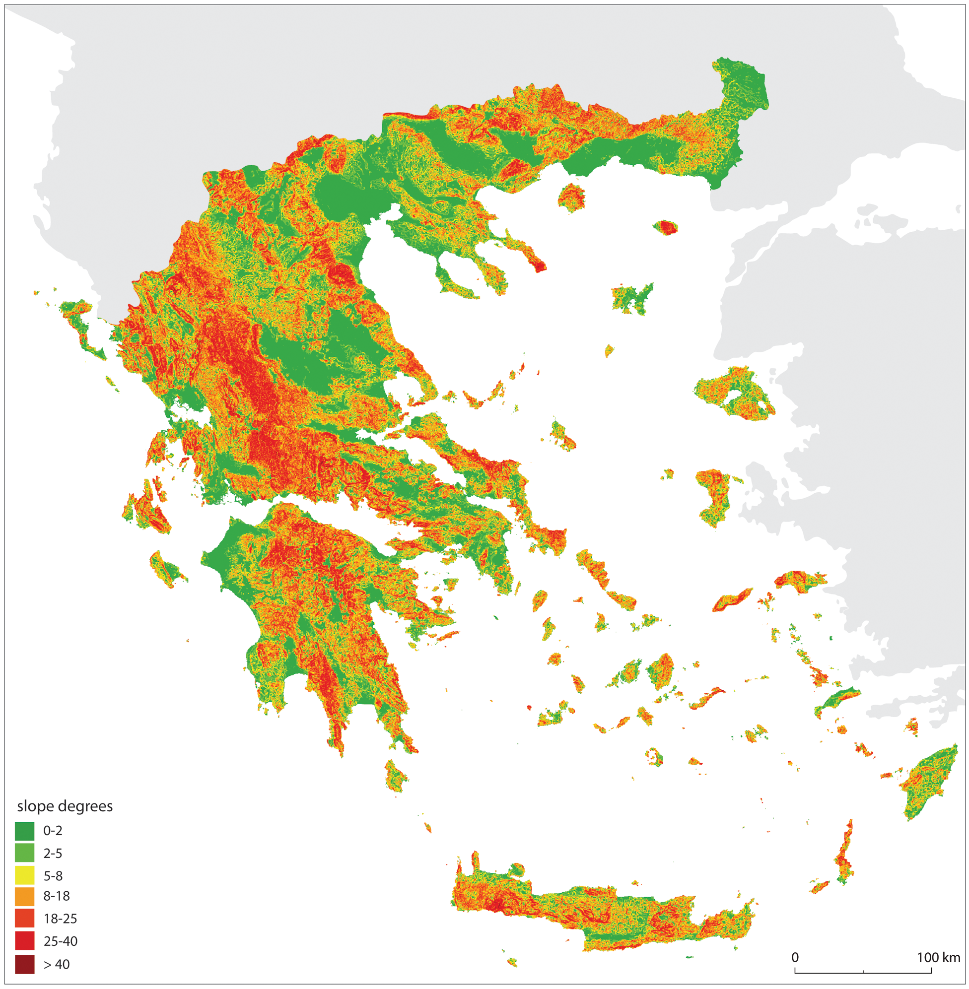
Employing the ‘nine-unit land-surface model’ of Dalrymple and colleagues (1968) in the form of a heuristic tool (cf. French 2003, 30-32), Tourloukis (2010) produced a slope map of Greece and used slope angle as a surrogate for mean local relief and as a morphological measure, in order to assess the potential for archaeological preservation and recovery as a function of surface steepness (Figure 2). On this basis, a quantitative and qualitative assessment was achieved, thereby evaluating how much of the Lower Palaeolithic record may have been lost compared to the geological record at our disposal, how much of it is likely to have escaped the biasing geomorphic agents, and what kind of geoarchaeological contexts we are facing today and we should expect to deal with in the future (Table 2). The conclusion that geological opportunities in Greece are limited and unpropitious for preserving early Palaeolithic material in stratified/primary contexts was explained in terms of landscape dynamics and their spatio-temporal specifics. Particularly, it was argued that Quaternary landscape evolution in Greece was primarily controlled by four main driving mechanisms: (1) a tectonic activity with rates of vertical and horizontal deformation that are among the highest in the entire Eurasia; (2) a markedly seasonal climate in which the seasonality of precipitation is the most important parameter, being accentuated mostly during glacials, and, in turn, affecting runoff and river flow fluctuations; (3) sea-level oscillations exposing and submerging large areas, at the same time controlling inland patterns of fluvial incision and aggradation; and, last but not least, as the land-surface manifestations of all of the above, (4) slope processes on a predominantly high-relief terrain with spatially restricted drainage basins, erodible lithologies, skeletal soils and an effectively strong slope-channel coupling. Rather than temporally continuous, landscape disturbance occurred in an episodic fashion and in the form of extreme erosional events of low duration but high amplitude and high frequency of recurrence, in time-windows that were pre-conditioned by the combined forces of some (or all) of the four above-mentioned factors. Changes to the thresholds at which a disturbance-event became effective could be due to climatic transitions (mostly cold-to-warm ones) at millennial, centennial or decadal scales, and/or associated sea-level changes (e.g. affecting base-levels of rivers); if not climate, tectonic movements would have been equally efficient as triggering factors. Following this line of reasoning, a landscape dominated mainly by transient landforms (cf. Brunsden and Thornes 1979; Phillips 1995) indicates that the fragmented and scanty status of the early Pleistocene archaeological record is to be interpreted as the outcome of the biasing and destructive effects of Quaternary geomorphic processes: in this sense, the ‘absence of evidence’ should not be understood as an indication of a former absence of hominins.
Figure 2. Slope map of Greece.

The map was produced in ArchGIS 9.2 and it is based on 1:250,000 topographic maps with a 20-m contour interval; adopted from Tourloukis 2010. The areas covered by the first slope class (0º-2º, shown in dark green) mainly represent the sedimentary basins and lowland coastal plains of Greece, which are also the places where the vast majority of Pleistocene sediments have accumulated. As a working hypothesis, Tourloukis (2010) argued that future investigations in search of Lower Palaeolithic sites should focus on areas of the first two slope classes, and particularly on basins that have been inverted in the Late Pleistocene and Holocene.
Table 2. Summary of main geoarchaeological conclusions deduced from a hypothetical classification of the landscape according to the nine-unit land-surface model.
| Unit | Slope Angle (degrees) | Geomorphic Process | Potential for Preservation | Archaeological Context | Archaeological Visibility |
|---|---|---|---|---|---|
| Assessments on archaeological context and visibility are to some degree of speculative nature and are noted here only as ‘most probable possibilities’. Artefact visibility, for example, can be high on lagged surfaces, low on depositional surfaces (because of burial) and somewhere in between (medium) on erosional surfaces. Reproduced from Tourloukis 2010. | |||||
| 1, 2 | 0 – 1 2 – 4 | soil formation | high | primary | low, medium? high? |
| 7 | 0 – 4 | alluvial sedimentation | medium | ?primary? secondary | low, medium |
| 4 | 45 to >65 | slope failure (landslides) | none | none | --- |
| 3, 5, 8, 9 | 26 – 45, possibly even higher | sheet erosion, soil creep, mass movements, channel corrosion, streambed transport | low | secondary, tertiary | high |
| 6 | modal angles | redeposition of colluvial material by mass movement, surface wash | medium | secondary | low, medium |
In essence, this study elaborated on the concept of landscape taphonomy, namely the assessment of the processes by which elements of the landscape become selectively removed due to the action of natural or cultural agents, resulting in a biased record of past landscapes –hence also a biased archaeological archive. Ultimately, this work demonstrated that evaluations of site distributions and occupation (dis)continuities or densities are likely to be flawed unless the observable patterns have been evaluated against the effects of geomorphic biases. Moreover, it showed how a geoarchaeological application at the landscape-scale may have considerable implications for upcoming archaeological investigations in Greece, not only because of its net results, but also as a methodological approach that sets novel points of departure for the designing of fieldwork practices: in this case, the aforementioned work sketched out new perspectives and narrowed down the focus on where to look for Palaeolithic material, as well as how to look for it. In the same vein, the study and interpretation of landscape dynamics can alter our understanding of the potentiality of a region for yielding new evidence: for instance, results presented elsewhere (Tourloukis and Karkanas 2012), emphasized the potentially central role of the Aegean region in hominin dispersals, since half of the Aegean Sea would have been subaerially exposed during most of the early Pleistocene. This conclusion (cf. Tourloukis 2010) opens up new prospects for future fieldwork in an area that was hitherto essentially neglected and it has already inspired new research on insular archaeology (e.g. Ferentinos et al. 2012).
While it is acknowledged by Mediterranean archaeologists (e.g. Barton et al. 2002; see papers in Athanassopoulos and Wandsnider 2004), the role of landscape taphonomy has been only limitedly explored in geoarchaeological research practiced in Greece, even though GIS-based investigations in this direction have been notably successful when focusing on micro-regions and/or individual survey areas (e.g. Bevan and Conolly 2002-2004; Gouma et al. 2011). However, geomorphic agents have significantly influenced the quantity and quality of the archaeological material that we find and collect from the modern land-surfaces or geological outcrops of Greece. Using an ecologically- and geomorphologically-informed perspective, ‘landscape geoarchaeology’ allows for a holistic, multidisciplinary and integrative approach to both the human-environment interactions and the way in which the archaeological evidence comes to be embedded into the geoarchaeological envelope.