Second phase: the mid-1980s to late 1990s debate over the climatic vs. anthropogenic impact on landscape changes
One of the main concerns of geoarchaeology is to understand landscape histories and the ways in which they have affected and co-evolved with human societies. Deciphering the role of climate is particularly important in such an investigation, for climatic parameters influence both human behavior and the preservation and visibility of this behavior in the archaeological record. Although generally weaker in amplitude than those of the last glacial cycle, suborbital climate fluctuations characterize also the Holocene and may occur rapidly (i.e. in a few hundred years or shorter), perhaps legitimizing the view of the present interglacial as “a period of climatic instability” (Jalut et al. 2009, 13). Holocene climate variability indicates that quasi-periodic changes could be abrupt and profound even in the absence of the voluminous and unstable ice masses of the Pleistocene (Mayewski et al. 2004). The general trend towards a warmer and wetter climate in the early Holocene of Greece was interrupted by short-term climatic deteriorations, when vegetation communities were subjected to repeated, centennial-scale setbacks, mirrored by decreases in arboreal pollen and occasional increases in steppic taxa, which probably reflect reduced moisture availability (Kotthoff et al. 2008). One such abrupt deterioration at around 8.2 ka (Geraga et al. 2010) is thought to be correlative with the well-known 8.2 ka cold event of the Northern Hemisphere (Alley and Ágústsdóttir 2005). The colder and drier conditions of this short interval are also recorded in the isotopic record of the Soreq Cave (Bar-Matthews et al. 1999) and it is possible that they correspond to a major erosional event in Theopetra Cave (Thessaly, Greece) as well as to a stratigraphic gap in Franchthi Cave, altogether suggesting a broader impact on the caves of the area (Karkanas 2001). According to a recent geoarchaeological study of major Neolithic sites in Greece, Cyprus, Anatolia and Bulgaria, the introduction of farming to South-East Europe may have been triggered by the markedly cold and arid conditions that prevailed around 8200 cal yr BP (Weninger et al. 2006; but see also Drake 2012). Aridification was gradually intensified during the mid- and late Holocene, culminating at around and after ca. 5.6 ka (Jalut et al. 2009) and short-term arboreal pollen minima (e.g. at ca. 5.6, 4.7, 4.1 and 2.2 ka) are thought to represent drought events in the Aegean region (Kotthoff et al. 2008). However, a slightly different picture is recorded in the southeastern Aegean Sea with a pronounced wet phase recognized between 5.4 and 4.3 Ka, before the onset of the late Holocene aridification (Triantaphyllou et al. 2009). Yet, for this younger part of the Holocene and due to the advent of the Neolithic period, it is difficult to distinguish climate-induced terrestrial responses from those that should be attributed to the human impact. Greece is nevertheless well suited to such an investigation, because it has a long history of human land use and a sub-humid to semi-arid climate that renders its landscape sensitive to climatic change and human interference alike (van Andel and Zangger 1990).
Indeed, the effects of anthropogenic landscape modifications on soil erosion and landscape development have been the focus of a number of geoarchaeological, geomorphological and ecosystem management studies in the Mediterranean in general and particularly in Greece (e.g. Allen 2001; Grove and Rackham 2001; Kosmas et al. 2002; Butzer 2005; Thornes 2009). Since the publication of Vita-Finzi’s classic work ‘The Mediterranean Valleys’ (1969), in which he argued for climate forcing behind major late Pleistocene and Holocene alluviation events, a long-lasting geoarchaeological debate has been generated (for thorough reviews see Bintliff 1992, 2002, 2005). There were two main controversial issues in Vita-Finzi’s work: first, the fact that he simplified late Quaternary alluviation into two main episodes widely separated in time (the so-called ‘Older’ and ‘Younger Fill’, dating to last glacial-early Holocene and late Roman to Medieval times, respectively); second, his suggestion that both of these major events of landscape change were basically climate-driven. Triggered by and/or in reaction to this controversy, a number of important geoarchaeological studies appeared, some of them advocating Vita-Finzi’s model (e.g. Bintliff 1975, 1976, 1977; Rackham 1982), but most of them presenting contrary viewpoints and essentially stressing the importance of anthropogenic impact in the evolution of the physical environment (Davidson 1971, 1980, 1988; Davidson et al. 1976; Raphael 1978; Wagstaff 1981; Pope and van Andel 1984; Demitrack 1986; van Andel et al. 1986; Brückner 1986; van Andel and Runnels 1987; van Andel and Zangger 1990; van Andel et al. 1990a; Zangger 1992, 1993, 1994; Jameson et al. 1994; James et al. 1994; Cavanagh et al. 2002). This debate and the associated studies signaled the beginning of a second phase of geoarchaeological investigations in Greece, and, as it is discussed below, left their own signature in both the history and the future prospects of the discipline.
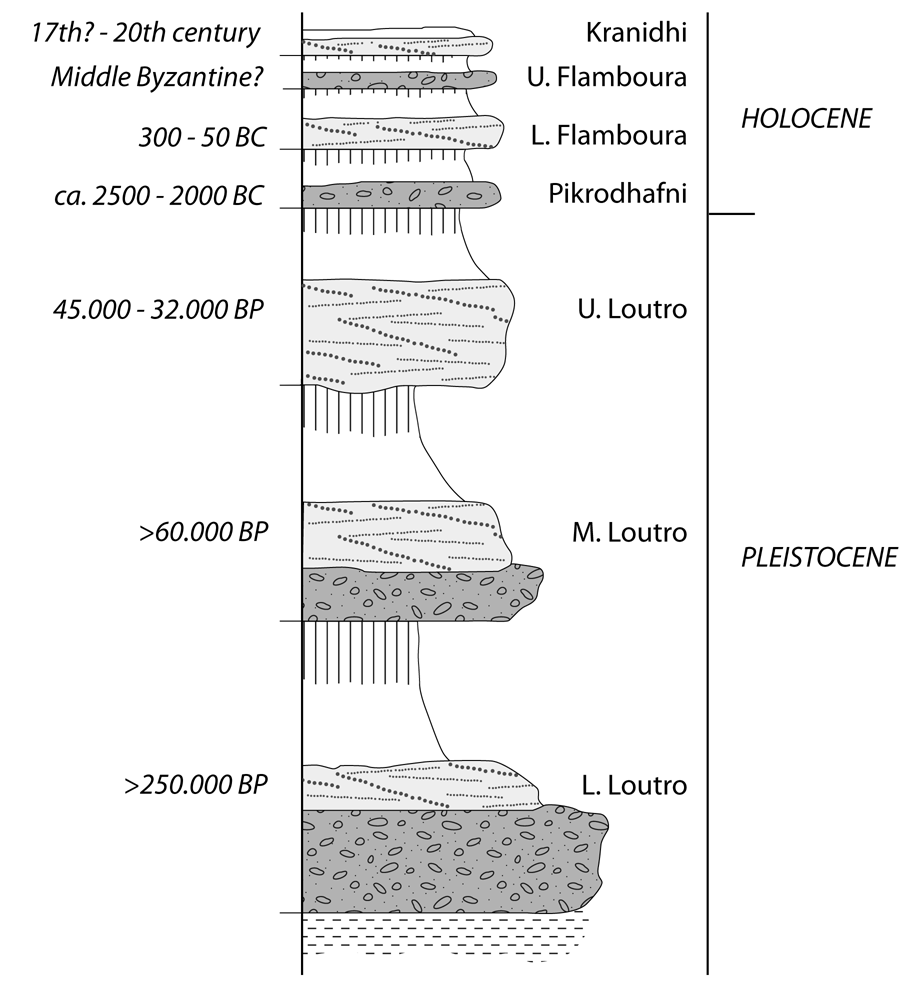
Geoarchaeological research shifted the ‘Vita-Finzi paradigm’ towards human agency, manifested in two main ways: settlement expansion accompanied with forest clearance and the resultant soil erosion, and changes in land use and agricultural practices, such as the abandonment of terrace preservation (e.g. van Andel et al. 1986; 1990a). Van Andel and colleagues (1990a) evaluated a number of geoarchaeological evidence from three major projects (in the Southern Argolid, the Argive Plain and the Larissa Basin); they concluded that all three case-studies point to landscape instability due to –and after– the spread of farming populations and the onset of woodland clearances, which resulted in extensive slope erosion and valley aggradation. Zangger (1992) stressed the diachronic nature of these human-induced landscape changes, showing also that such disturbances differ from region to region according to physiographic characteristics and settlement history. All the same, most of these studies entail some recurrent themes with respect to causal factors and consequential effects. For example, triggering parameters and processes inferred include mainly a combination of the following: the expansion of farming settlements; forest clearance; intensive cultivation, cropping and/or over-exploitation of fertile soils; pastoralism and related vegetation disturbance by animal husbandry (grazing, etc); inadequate soil conservation and ineffective or total abandonment of terrace maintenance and gully check-dams; economic and demographic circumstances and policies; settlement expansion into upland, marginal areas (Pope and van Andel 1984; van Andel et al. 1986; van Andel and Zangger 1990; van Andel et al. 1990a; Zangger 1992; Whitelaw 2000; Halstead 2000). Erosion and destabilization or, alternatively, stability, is inferred from geomorphological, sedimentological and pedological indications from the depositional archives, generally encompassing evidence and conclusions such as the following: soils indicate periods of stability (e.g. Pope and van Andel 1984); erosional events are envisaged as catastrophic sheet erosion on slopes (e.g. van Andel et al. 1986); gully erosion stripped off soils, which were then deposited in valley bottoms as stream-flood deposits, whilst debris flows have also been feeding many of the Holocene alluvia (Figure 1; van Andel et al. 1990a); shifts to instability, signaled either by mass movements (e.g. debris flows) or channel aggradation, can be abrupt (Pope and van Andel 1984). In most –if not all– explanatory schemes the degradation of vegetation by cultural or natural processes (or both) is a general prerequisite (e.g. van Andel et al. 1990a; James et al. 1994; Lespez 2003).
Figure 1. Quaternary alluvial sequence from southern Argolid (Peloponnesus).
Cobbles with a chaotic structure indicate debris flows, whilst stratified gravels are streamflood deposits; blank zones are overbank loams and vertical lines denote soil profiles. Although the dates give only approximate ages, they do highlight an apparent discontinuity in alluviation events. Modified after van Andel et al. 1986: Fig. 4.
Anthropogenic slope alteration, agricultural practices, land abandonment or change of land use, all may result in contrasting effects for the ability of soils to resist erosion: in some cases, such parameters lead to the deterioration of soils, whilst in other contexts they tend to improve soil stability (e.g. see papers in Conacher and Sala 1998 and in Geeson et al. 2002; Grove and Rackham 2001). Likewise, there is ongoing discussion about the role of terraces in erosion control and whether abandonment of terraced cultivation does indeed result in increased erosion or not (Allen 2009). Terracing affects artefact mobility and hence the integrity of archaeological sites, whereas terrace construction methods may either impede or improve archaeological preservation and visibility. In a recent investigation on the implications of polycyclic (prehistoric and historic) terracing in Kythera Island, Krahtopoulou and Frederick (2008) report that after terrace abandonment, the main types of erosion are sheet wash and gully erosion, the latter affecting mainly unconsolidated formations on steep topographies, occasionally causing almost complete denudation of the slope, which in turn produces significant sediment flux to the local fluvial system. Another recurrent feature in studies of the relation between land use and erosion is the apprehension of the importance of slope gradient. For example, neglect or abandonment of terraces on steep slopes is often thought to have been followed by erosion and downslope sediment redistribution, which may result in different artefact densities between steep and gentle slopes (e.g. James et al. 1994; French and Whitelaw 1999). As expected, slope inclination becomes more significant mainly on the upper and middle reaches of the hillslope-channel system (evidenced as e.g. debris flows and streamflood deposits in alluvial/colluvial units), whilst it may be less effective in the lower valleys and coastal plains where flooding predominates during erosional episodes (evidenced as e.g. overbank loams in floodplain deposits; van Andel et al. 1990a).
Overall, the aforementioned studies demonstrated the contribution of “man’s role in the shaping of the eastern Mediterranean landscape” (Bottema et al. 1990) and showed that soil erosion, valley alluviation and landscape (in)stability may have been preferentially connected with human settlement histories. More importantly, this corpus of research has brought to light a number of conceptual and methodological weaknesses in geoarchaeological approaches and it is this very same critique generated, which should be deemed fruitful. For instance, inasmuch as climatic forcing was invoked based on an assumed contemporaneity of landscape change, so was anthropogenic causation called upon to interpret a postulated temporal correlation between landscape change and cultural phenomena; however, correlation or coincidence does not straightforwardly prove causation (Halstead 2000; Brown 2008). Because of the different thresholds that operate in geomorphic systems (e.g. Schumm 1979), there can be considerable time lags between natural- or human-induced causes and their effects on the landscape. Furthermore, local and regional diversity in geological substrates, topography, vegetation patterns, climatic regimes and settlement histories complicate the degree in which geomorphic change can be synchronous across different regions and/or relatively contemporaneous to archaeological patterns. Even if this sort of spatial-temporal variation was in fact acknowledged (e.g. Pope and van Andel 1984; van Andel et al. 1990), there still has been a trend to fit dates from different depositional sequences into a common model of correlation with settlement patterns (Bintliff 1992; Whitelaw 2000). Being currently much better but significantly worse in the 1990s, the available chronological resolution is usually too coarse to firmly support a causal linking, be that natural or cultural (Endfield 1997; Krahtopoulou 2000). It is in these lines that the ‘climatic vs. anthropogenic impact’ debate effectively forced researchers to recognize that, as Whitelaw puts it (2000, 145, 150),
“we are likely to be dealing with much more subtle interactions between climate, soils, vegetation, and human exploitation strategies, which played through in different ways, even in adjacent valley systems […] We are likely to develop a better understanding of the different processes involved by paying more attention to local differences, and by considering in their own right the implications of different variables, such as overall population levels, the relative sizes of individual sites, the relative distribution of population among sites of different sizes, and the location of different types of sites within the landscape” |
||
| --Whitelaw, T. | ||
Bintliff (2002) stresses two main issues as of critical importance in this discussion: the role of extreme events, and the complexity that arises due to the interactions between different geomorphic and cultural variables. He suggests that instead of focusing on climate or anthropogenic causation as monocausal or deterministic alternatives, there is much stronger evidence for viewing geomorphic and environmental parameters as setting up a ‘pre-adaptation scenario’ of a sensitive landscape, where cultural and natural trajectories intersect to create ‘windows of opportunity’, during which extreme erosion events are likely to occur. This viewpoint is best understood when considering Mediterranean landscape evolution as a “punctuated equilibrium rather than a uniformitarian process of prolonged change” (Bintliff 2002: 418). From this perspective we can evaluate the evidence for prolonged times of stability interrupted by erosional events, the latter being rare and brief but extreme enough to have caused large-scale disruptions, which are now occasionally and discontinuously preserved in depositional sequences in the form of e.g. alluvia and colluvia (Pope and van Andel 1984; van Andel et al. 1990a; Bintliff 2002).