Stop C.
Stop C is at a fork in the road, and it is easy to spot because of the tiny chapel, called Agios Nikolaos, the Chapel of St. Nicholas (Figure FT-7), which is located at Stop C (see Figures FT-1, 2).
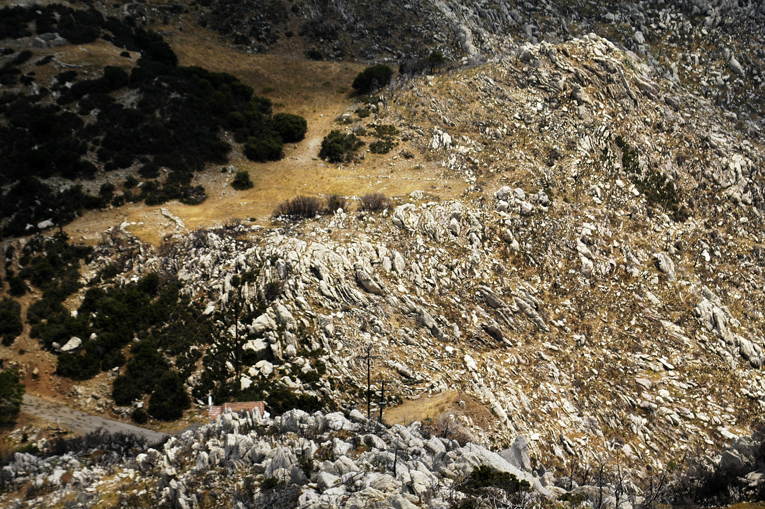
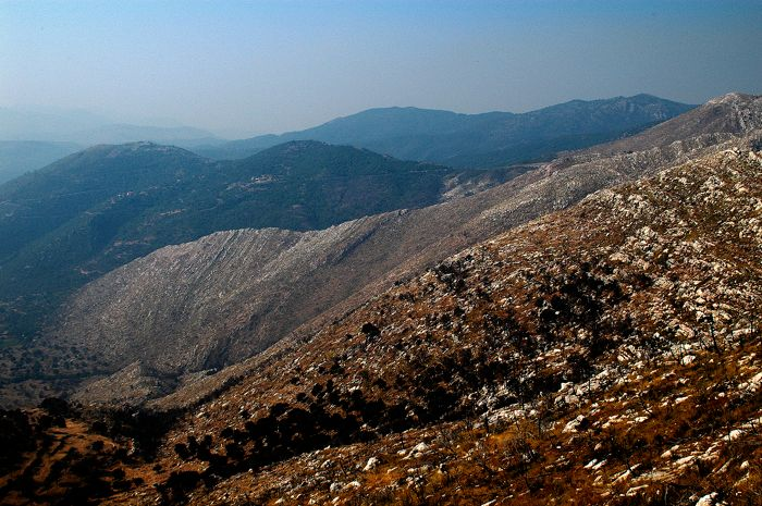
Figure FT07. View of St. Nicholas Chapel, and Stop C, from above.
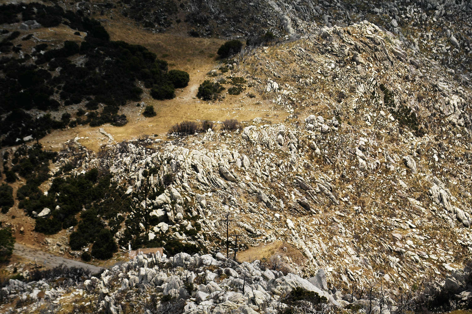
A. Northeast-directed view of Stop C. Although this image resembles an aerial photograph, the location from where I took this photo is the top of a tall, steep-sided ridge. My companions during this shooting are in Figure FT-7B. Note the red-tiled roof of the Chapel of St. Nicholas. All of the bold limestone bedrock belongs to Thick White Limestone Beds. The grassy areas are underlain by Flysch Transition Beds. Note the traces of compartmental faulting that shifts the contact between the two Pindos Group formations exposed near Stop C.
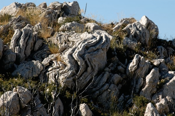
The bedrock at this location is Thick White Limestone Beds. The properties of this formation are exquisitely displayed in outcrops behind (i.e., north of) the chapel (Figure FT-8). In particularly you will see that bedding is steeply inclined and marked by pervasive stylolite dissolution, producing stylobedding. The bedding is strongly folded, and the folds tend to be overturned to recumbent (see Figure FT-8). All of these strata occupy the Pan thrust sheet.
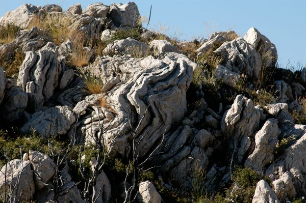
Figure FT08. Folded Thick White Limestone Beds behind St. Nicholas Chapel.
Folded limestone beds on north side of the Chapel of St. Nicholas. This is the western overturned limb of the St. Nickolas syncline. The formation is Thick White Limestone Beds.
If you ‘backtrack’ down the hill for ~100 m or so, you will be able to see the zone of contact between Thin Platy Limestone Beds and the Thick White Limestone Beds. (The pink/purple beds belong to Thick White Limestone Beds formation). If you stand in the small parking area south of the chapel and look southwest toward and up the ridge which is south of the road, you will see a good example of the landscape expressions of both of the limestone formations. What is striking is that Thin Platy Limestone Beds, so apparently resistant in roadcuts, has very poor outcrop expression on the steep hillslopes. It weathers into a blocky, rubbly, grass-covered slope. In contrast, the beds within Thick White Limestone Beds crop out like resistant struts with significant continuity, and they stand out in sharp contrast with “furrows” along the traces of weaker lithologies within this formation (Figure FT-9). [Section VI-E of the companion paper describes “Thick White Limestone Beds].
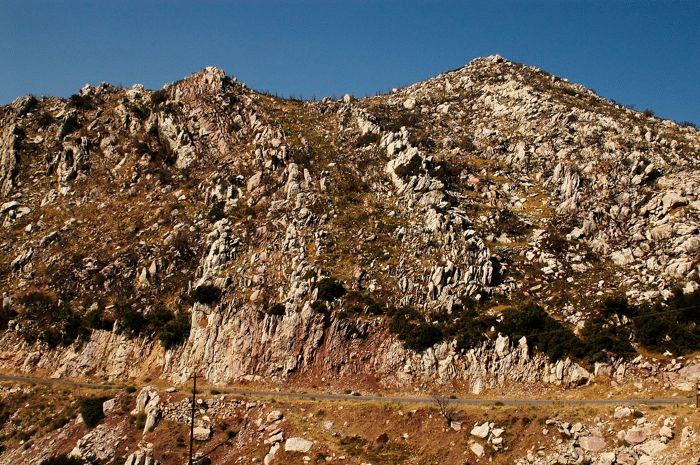
Figure FT09. Landscape expression of Thick White Limestone Beds.
Southwest-directed views of landscape expression of Thick White Limestone Beds. Note “furrows” that are underlain by weak mudstone interbeds.
For those who have the time and interest, head northward from Stop C to Stops C1 and C2. Start off on the path that comes out of the brush on the north side of the chapel near the road. Once beyond the thick brush you will see that the landscape opens up, and in fact you will find yourself going along the edge of a shallow grassy sinkhole depression. From Stop C, you will be walk northward along the ridge crest for ~0.5 km; your ‘target’ (Stop C1) is a 2m-high geodetic monument that can be spotted from some distance away. The monument is called Pseiliko, and registers an elevation of 1039.82 m.
Stop C1.
From the location of the monument look generally westward (Figure FT-10) where you will see the village of Ano Karyes (see Figures FT-1, 2). Ano Karyes has been the base of field operations for the Mt. Lykaion Excavation and Survey Project. On the skyline to the west you will see a white cliff face, beneath which are large scree slopes (see Figure FT-10). The cliff and scree slopes are expressions of the active fault system bordering the eastern edge of the St. Elijah klippe, which strikes NNE, dips ESE. The normal faulting accommodated by this fault system has incrementally dropped the high-plateau upland of Mt. Lykaion to lower and lower elevations, in part through a series of fault-bounded steps. The rocks of this high-plateau upland are part of the Zeus thrust sheet, though this is not obvious from here, for the trace of the Lykaion thrust fault is covered by landslide deposits. [Section VII-D3 of the companion paper describes “Active Faulting Bordering St. Elijah Klippe on East”].
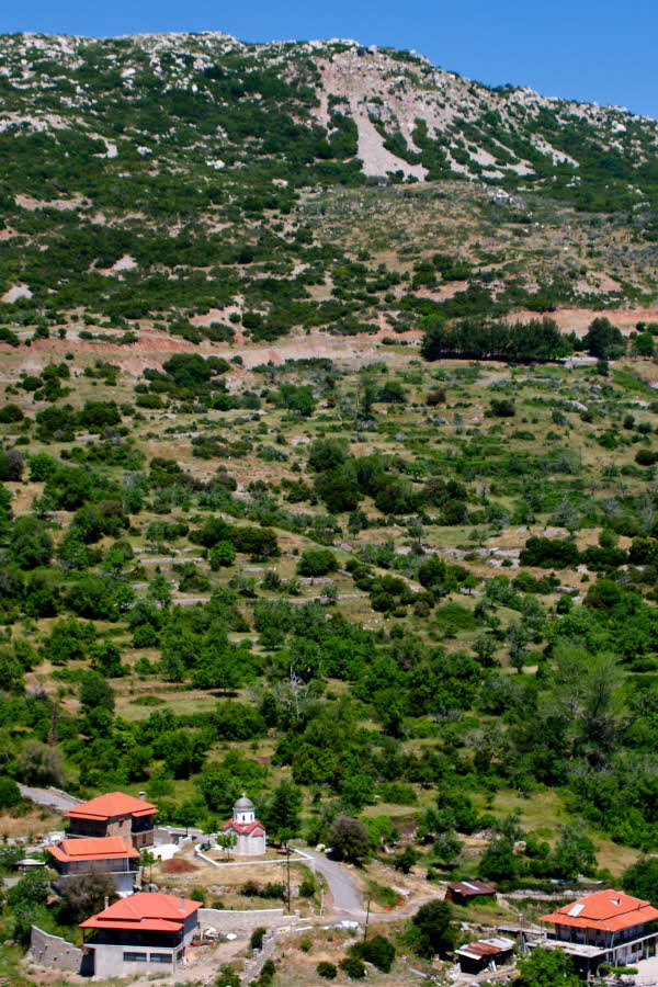
Figure FT10. View from C-1 toward Ano Karyes and landslides above.
Photograph showing view to the west from Pseiliko. In the foreground is a part of the village of Ano Karyes. In the distant background is the eastern precipitous margin of Agios Elias. This boundary is demarcated by active normal faulting. Oversteepening by faulting is creating landslides and rock falls, as can be seen from great distances away.
The white cliff face is composed both of Thick White Limestone Beds and landslide colluvium. The northernmost and westernmost parts of the village of Ano Karyes appear to be built on top of a mantle of coalescing landslides. As is the case throughout Arcadia, earthquakes impose greatest damage on houses and villages built on landslides. This certainly was true of the Megalopolis earthquake in 1965.
Stop C2.
For those who have the time and stamina, proceed now to Stop C2 by walking north-northeast for ~0.4 km (see Figures 1, 2). Though Stop C2 is plotted as a discrete point on the map (see Figure FT-1), the objective is to walk around to places where there are good views of folding. The Three Gorges anticline (Figure FT-11) can be seen to the north, as expressed in Thick White Limestone Beds on the south-facing wall of a deep canyon (Figure FT-11. Steeply dipping overturned strata of the St. George anticline can be seen to the northeast (see Figures FT-4 and FT-5). Now, turning southward, the near-isoclinal Cretea syncline may be evident (Figure FT-12). (Gaining a clear view of the Cretea syncline may require contouring southeastward to the top of the next ridge). The bedrock within this syncline consists of Thick White Limestone Beds and Thin Platy Limestone Beds (Figure FT-12). This combination of views, in concert with examination of the geologic map (see Figure FT-2), offers an excellent picture of the macroscopic folding within the Pan thrust sheet. This folding is intimately related to thrust faulting and crustal shortening of Pindos group sediments that took place from late Cretaceous through Oligocene.
Figure FT11. View of Three Gorges anticline and St. George’s spire

In the foreground is the expression of the Three Gorges anticline. In the background is the hilltop spire on top of which is built the St. George Chapel. The chapel lies close to the trace of the St. George (overturned) anticline.
Figure FT12. View of Cretea syncline.

South-directed view of the Cretea syncline. The eastern limb is overturned. Strata in right foreground are Thick White Limestone Beds.
Now return to the vehicles and drive westward from the Chapel of St. Nicholas to Stop D, a distance of 0.8 km.