II. PURPOSE OF THIS PAPER
The Sanctuary of Zeus, Mt. Lykaion, is the object of investigation of the Mt. Lykaion Excavation and Survey Project, jointly led by Dr. David Romano (The University of Pennsylvania Museum of Archaeology and Anthropology), Dr. Mary Voyatzis (Department of Classics, The University of Arizona), and the Thirty-Ninth Ephorate of Prehistoric and Classical Antiquities at Tripolis, under the auspices of The American School of Classical Studies at Athens (http://lykaionexcavation.org/).
Scant archaeological excavation preceded the Mt. Lykaion Excavation and Survey Project, which was initiated in 2004. The notable exception was the work by K. Kourouniotes (1903; 1904; 1905; 1909), whose investigations are summarized by Romano (http://lykaionexcavation.org/). Kourouniotes excavated in several parts of the sanctuary in 1897, 1902, and 1906. The finds he recovered (e.g., coins, pottery, figurines) showed that activity at the altar dated back to as early as the late 7th century BC, but peak activity was during the Classical period.
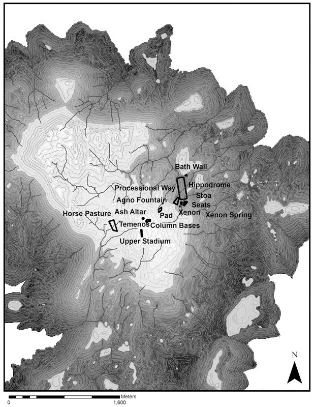
David Gilman Romano (1997) built upon the work of Kourouniotes and conducted an architectural and topographical survey at the site. He mapped the various archaeological elements, a simplified rendition of which is shown in Figure 5: a lower part with the hippodrome (horse- and chariot-racing track), stadium (located within the hippodrome), bath, xenon (lodging place for those who came from afar), stoa (connected porticos under one roof), and the Agno fountain (a once very productive spring); and an upper part with temenos (sacred precinct), column bases, and an ash altar (place of sacrifice of animals and dedications of offerings) (Figure 3). Romano (1981, 1997) concluded that the stadium was one of the most important in the Greek world, and noted the hippodrome on Mt. Lykaion is the only extant and visible example throughout the Greek world.
Figure 5. Topographic map of Sanctuary of Zeus, showing archaelogical elements
Topographic map of the summit area showing the chief archaeological elements within the Sanctuary of Zeus on Mt. Lykaion. Contour interval is 4 m. The white areas are the highest ground. The dark areas dramatize the steep drop-off on all sides from the Sanctuary of Zeus. This map is based on the work of Romano (1997; and ongoing).
When the Mt. Lykaion Excavation and Survey Project was initiated, I was invited by Dr. Romano and Dr. Voyatzis to carry out geological investigations that would inform interpretation of history and archaeology. The only prior geological investigations that touched upon this area was the regional geological mapping carried out by Lalchos (1973), who produced the Kato Fighalia Sheet at a scale of 1:50,000, and by Papadopoulous (1997), who produced the Megalopolis Sheet, also at a scale of 1:50,000. No reports or articles accompanied this mapping. Furthermore, no detailed investigations had ever been carried out within the Sanctuary of Zeus proper. I have carried out geological mapping during the summers of 2004, 2005, 2007, 2008 and 2009 (total of 16 weeks overall). The limits of the Sanctuary of Zeus per se are somewhat arbitrarily defined, but all of the archaeological elements occupy comfortably an area of 1.5 km2. I found it necessary to map a significantly larger area (~25 km2) in order gain fuller perspective of the subregion within which the site is located, and to be able to trace critical contacts into the sanctuary site. Thus the map area described in this paper occupies an area of, which I mapped in great detail at a scale of ~1:6000.
The emphasis of this paper is on the overall geology of the Sanctuary of Zeus, but with a particular focus on structural geology and tectonics. It concludes with a geological field guide to the area (Appendix A). Other manuscripts that I am preparing will emphasize to a greater degree the geoarchaeological dimensions of the Sanctuary of Zeus, and these will become useful companion pieces to the fundamental geological descriptions, observations, interpretations, figures, and maps contained in this contribution.
Please note that all headings in the manuscript are denoted in Times New Roman (e.g., VI-A). This is to create ease of cross-referencing from the field trip guide to supporting facts and interpretations in the body of this text.