III. PLATE TECTONIC SETTING
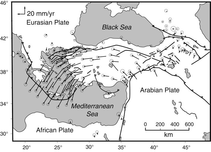
The contemporary plate tectonic setting of the Aegean has been well researched. Based on results of Global Positioning System (GPS) geodesy, Greece itself, embedded within the Aegean tectonic plate, is known to be moving S40°W at a rate that from place to place ranges from 2 cm/yr to nearly 4 cm/yr (Le Pichon and others, 1995; Oral and others, 1995; Reilinger and others, 1997; Cocard and others, 1999; McClusky and others, 2000) (Figure 6). Mt. Lykaion, in particular, moves 3.7 cm to the southwest each year. The sustained plate movement is the result of simultaneous push and pull forces affecting the entire eastern Mediterranean region. The push comes from the northeast, where the Anatolian tectonic plate is being squeezed westward into the Aegean region by the slow-motion (2 cm/yr) ramming of the Arabian plate into Turkey (McKenzie, 1970; Reilinger and others, 1997). The pull comes from the south, where along the seismically active Hellenic trench the African plate is subducting under the Aegean crust (e.g., Jackson, 1994). The subducting African plate is foundering in such a way that a suction force is created, which pulls the Aegean plate toward it and increases the velocity of movement to 4 cm/yr (Reilinger and others, 1997).
Figure 6. Plate setting and GPS velocity vectors for Eastern Mediterranean.

Global Positioning System (GPS) map showing velocity vectors for reference stations. From McCluskey and others, 2000, figure 2, p. 5703.
With northern Greece moving 2 cm/yr southwesterly, and southern Greece moving nearly twice as fast, the region finds itself being actively stretched, and thus thinned, tectonically (McKenzie, 1978; Jackson and others, 1982; Jackson, 1994; Clarke and others, 1998). The Gulf of Corinth is a dramatic example of the stretching (Jackson and others, 1982; Roberts and Stewart, 1994; Roberts, 1996; Briole and others, 2000; Sorel, 2000; Morewood and Roberts, 2001). Abundant normal faulting accommodates the extension. This faulting has been described and documented by many workers, including Roberts and Jackson (1991), Stewart and Hancock (1991), Jackson (1994), Jackson and McKenzie (1999), Roberts and Ganas (2000), and Goldsworthy, Jackson, and Haines (2002). Van Hinsbergen and others (2006) emphasized that the present-day extensional deformation, which is producing the normal faulting, began in the late Pliocene in southern Greece. The Cyclades islands disclose the results of profound subsidence over a vast region in the past 20 million years (Lister and others, 1984; Jolivet and Patriat, 1999; Jolivet and others, 2004).
A fundamental expression of the fault activity is the blizzard of earthquake activity that Greece experiences continuously (Ambraseys and Jackson, 1990, 1998; Jackson, 1994; Reilinger and others, 1997, see Figure 2, p. 9985; McClusky and others, 2000; and Morewood and Roberts, 2001). The Aegean region is very active seismically. Fault-plane solutions are varied, but include abundant earthquakes related to active normal faulting, i.e., faults accommodating the crustal stretching. Ambraseys and Jackson (1990) reviewed all earthquakes of magnitude 5.8 and greater that had occurred in Greece, and concluded that the cumulative displacements can account for a total north-south stretching of Greece by ~45-70 cm during that time interval.
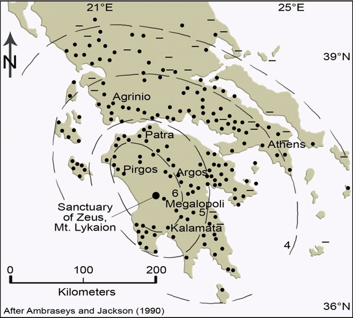
Mt. Lykaion has not escaped the earthquake activity caused by the active extension. A revealing example is the devastating Megalopolis earthquake (Ms = 5.9) of April, 1965), which caused extensive damage to our host village, Ano Karyes, as well as surrounding villages (Ambraseys, 1967; Ambraseys and Jackson, 1998). The epicenter of this earthquake was merely 4 km northwest of Mt. Lykaion (Figure 7). It appears to have occurred at shallow depth, approximately 10 km below the surface (Ambraseys, 1967; Ambraseys and Jackson, 1998). Its effects were felt within a 300,000 sq km area of the Peloponessos, killing 20 people and injuring 160. Of the 99,000 houses in the affected region, 110 collapsed, 5000 were damaged beyond repair, 6000 were damaged seriously, and 7000 were slightly damaged (Ambraseys, 1967). Ambraseys (1967, p. 1030) described how accelerations were amplified in landslide areas, emphasizing high number and large sizes of slides either created for the first time or reactivated by the shock. Indeed, a part of the village of Ano Karyes, the base of operations for the Mt. Lykaion Excavation and Survey Project, is built on an extensive array of landslide deposits, and some houses were badly damaged.
Figure 7. Map showing impact of Megalopolis earthquake.
Map representing The April 5, 1965 Megalopolis earthquake (MS5.9). Note location of the Sanctuary of Zeus. The epicenter of this earthquake was located 4 km northwest of the sanctuary. Contours represent lines of equal intensity of ground shaking, as deduced from documentation of damage on the ground. Magnitudes of intensity are in relation to the Modified Mercalli Scale: VI = felt by everyone, and people run outdoors; some heavy furniture moved, chimneys become damaged, plaster falls. III = felt quite noticeably indoors, especially on upper floors of building, but many people do not recognize it as an earthquake. From Ambraseys and Jackson, 1990, figure A40, p. 702.