Geological hazards
Brief history of urban development (by Andrea Bollati)
Roma has developed over almost 3000 years. Accurate reconstructions of the urban evolution of Roma have allowed to trace the history of the city (Muratori et al., 1963). The transition from the Archaic village to the Republican age town then to the Imperial Age capital city had been accompanied by an impressive urban development, which culminated between the 1st and the 4th centuries C.E. (common era), when the city hosted more than 2 millions people (Fig. 22). In the Medioeval time, under the temporal power of the Catholic church, the city experienced a drastic decline (Fig. 22), oscillating around some tens of thousands people, a number which did not rise through the Renaissance till the XIX century (Fig 22a,f). The Tiber alluvial plain and its tributary valleys have been intensively urbanised mostly in the last 150 years, after the unification of Italy under the kings of Piedmont. Roma became the capital city after 1870 and developed quickly. The advantages of the regular and flat morphology have been preferred, disregarding the hazards which kept these alluvial areas largely un-settled for millennia.
From the origins to the Hellenic city (12th – 2nd centuries B.C.) – Fig. 22a
The first settlements developed between the 13th and the 12th century BC; they were distributed on the heights converging towards the River Tiber.
Many favourable factors make this site a good choice: ships can sail up the river which constitutes an important communication route, the proximity of the mouth to the heights representing the first landing point for merchant ships sailing towards the interior of the territory, the abundance of affluent rivers and springs, the position of the hills converging towards a bend of the river, the configuration and elevation of the hills permitting to control and defend the territory below as well as the river crossings, the morphology of the heights with mainly flat summits and the existence of a plateau embracing all the hills, allowing easy connections between the different settlements (Bollati R.; in Muratori et al., 1963).
In the 11th and 10th centuries the settlements developed downstream, towards the intersection between the heights and the bottom or the valley; in the 9th century on each hill-top, the initial settlements merged into unitary systems surrounded by the first defensive works; in this period the population numbers approx. 5,000.
The groups of hills join in confederations (7th century); hence they merge (8th and 7th century) in a single unit (defended by fences linking the various systems) gravitating towards a common forum. The population increases from approx. 10,000 to 20,000. During the 4th and 5th centuries the initial unit is commonly administered and delimitated by continuous fortifications.
Under the government of the Etruscan dynasties the population reaches 80,000 inhabitants.
During the 5th century the building expansion outgrows the “pomeriali” boundaries (sacred land beyond the city walls, where building was forbidden). During the period of conflicts against the neighbouring populations, until the Gallic invasion, the population reaches 100,000 inhabitants. In the 6th century the first reconstructions are performed under the pressure of renewing urban needs (period of the Sannite wars and expansion to the South). In the 3rd and 2nd B.C.E. (Punic wars period) the town undergoes a specific urban planning by sectors: the heights and their spurs are occupied by exclusive neighbourhoods, the valleys are occupied by high density residential and commercial quarters, the sites along the Tiber house the naval and provision quarters while the areas beyond the wall are occupied by military quarters and commercial activities. Towards the end of the 2nd century B.C.E. the population adds up to about 300,000 people.
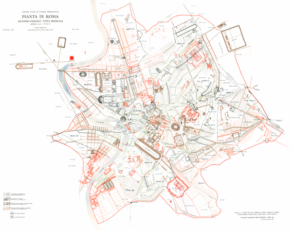
The imperial city: from the conquest of the supremacy in the Mediterranean area to the fall of the Empire (1st B.C.E. – 4th C.E. centuries) - Fig. 22b
Between the 1st century B.C.E. and the beginning of the 1st century C.E. (period of the emperors Silla, Caesar and Augustus) the urbanization of the city is realised by three different interventions: new fortifications are built, the “pomeriale” perimeter spreads out (also in the transtiberial area) and a long series of renovations begins, including the creation of huge architectural structures and the tracing of new main roads (Marinucci G.; in Muratori et al., 1963). The city plan at the beginning of the 1st cent. C.E. is organised in: the imperial quarters on the Colle Palatino, the patrician quarters on the Esquilino, the plebeian quarters on the Aventino, Celio and Trastevere, the artisan – commercial quarters are hosted in the river valley, the suburbs along the consular roads, the military quarters are located in the “extrapomeriale” areas.
In the 1st century a.d.(period between the emperors Tiberius and Nerva) the urban expansion includes monumental complexes in the north-west and south-east sectors; private buildings support this expansion process with the creation of houses interposed between the above-mentioned complexes and with the edification of new houses located in peripheral lots. In this period the population exceeds one million inhabitants.
Between the 2nd and 3rd century (period between the emperors Trajan and Constantine) the imperial planning is completed, followed by the last phase of urban development and the final asset of the city boundaries, coinciding with the Aurelian walls; in this period the first Christian cult sites spring up and the city is divided in 7 ecclesial regions with a new interpretation of the city structure. Between the end of the 3rd century and the beginning of the 4th the large central establishments are abandoned, following the removal of the imperial court from Rome.
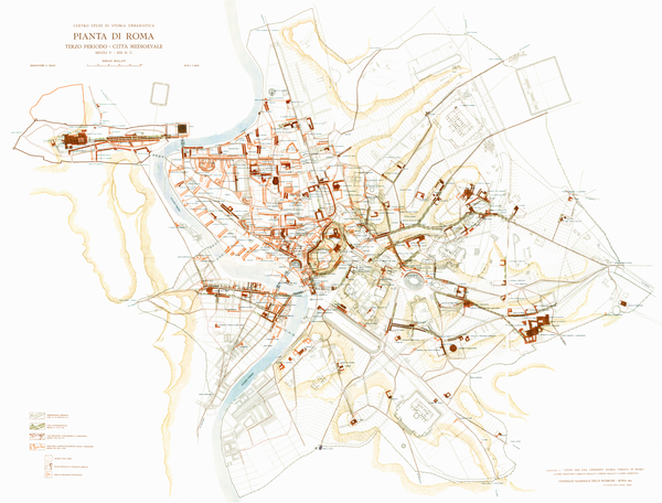
The medieval city (5th - 14th centuries) - Fig. 22c
In the 5th century the grand political and military buildings are abandoned, a contraction of the collective provision systems takes place, the homogeneity of the urban fabric declines; additionally the pagan temples close and the basilicas develop together with the pertinent connecting paths. At the end of the Roman Empire the population adds up to less than a half million inhabitants.
During the 6th century the destination of the structures progressively changes: still maintaining the architectural unity they are subdivided or grouped for the new functions (pilgrim and foreigner hospices, hospitals, monasteries and fortifications); so, the beginning of the centralisation process takes place in the city, which progressively loses its secondary peripheral structures (Bollati S.; in Muratori et al., 1963).
In the 7th century the diagonal north-west south-east trend starts in relation with the political-religious interests around the Lateran, Forum and Saint Peter areas. During the Byzantine period the inhabitants of Rome are around 100,000.
In the 8th century the residences on the heights become progressively isolated; the ancient public buildings in the Campo Marzio begin to change into religious and residential complexes.
The 9th century sees the birth of the “contradas”, the residential fabric along the river valley decreases while in the next century the city districts (rioni) begin to develop. Between the 8th-9th and 10th centuries the population declines from about 50,000 (Carolingian period) to 30,000 (Othonian dynasty).
During the 11th century a new growth phase starts, with the formation of an urban strucure connected with the old religious interests and the new civil interests; the 12th century sees the establishment of the City-State, the definition of isolated centres organised around the elements of churches and fortresses, the birth of craftwork distrists and the specialisation of collective centres in markets, craft and commercial streets.
In the 13th century the residential isolated areas progressively merge together following the new street network of the future Renaissance city.
The population remains around 35,000 inhabitants, still with up and down events: periods of decline coincide with the Norman invasion (second half of the 11th century) and the transfer of the Papal court to Avignone (during the 14th century).
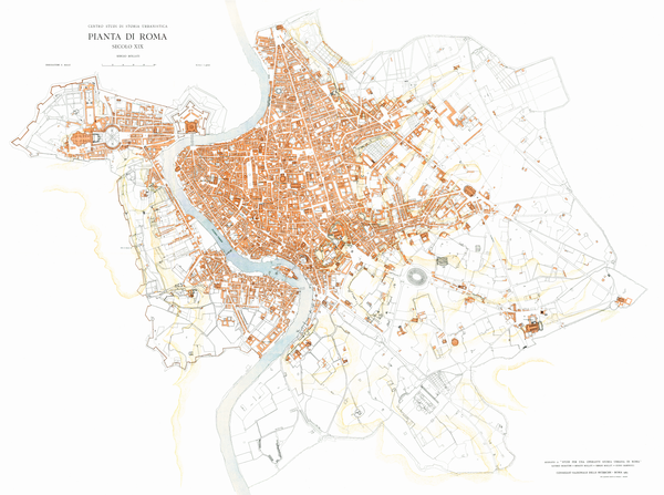
The Renaissance city and the modern city (15th–20th centuries) - Fig. 22d,e,f.
Between the years 1400 and 1550 the city is renovated (coinciding with the return of the Papal court) with restorations and the first suburban planning, the drawing of city plans in the central sectors (new specialised hubs like piazza Navona and Campo de’ Fiori develop), extension of suburban areas, building growth in the new and ancient sectors and completion of defensive works (Bollati R.; in Muratori et al., 1963). During this period the population increases from 30,000 to 60,000 inhabitants.
Between the year 1550 and 1748, the city develops according to the building policy of the popes: suburban planning and drainage, the first straight roads outside the ancient centre (1550-1572); connection between the suburbs and growth of new suburbs, especially in the eastern area, with the epicentre corresponding to the basilica of S.M Maggiore (1572-1605); completion of the minor internal road axis and the development of the great baroque structures, including churches with important façades, big fountains and architectural arrangement of natural elements such as the stairs of Trinità dei Monti (1605-1748). At the end of the 18th century the population grows to the 150,000 inhabitants.
From the year 1800 to 1870 (year in which Rome becomes the capital of Italy) a new city develops alongside the ancient one; the new urban plant develops in the hilly areas of Quirinale, Viminale and Esquilino, gravitating towards the new axis of via Nazionale.
The plan of A. Viviani dating 1873 suggests the realisation of Via Nazionale, the drawing of Prati district and of all those within the Aurelian walls, pivoting around the axis S. M. Maggiore-Porta Maggiore, while piazza Vittorio Emanuele becomes the centre of the new capital between the old area and the Termini Railway Station.
The Urban Plan of Santjust di Teulada of 1908 includes the urban developoment of all the Eastern area between via Tiburtina and Prati up to the new district of Piazza d’Armi beyond the Tiber and extending to West and South with the Gianicolo and Archeological Parks up to the Vittorio Emanuele Monument.
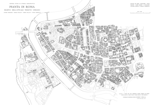
The 1931 plan brings drastic demolitions (eg. Augustean Area, Corso Rinascimento, via dell’Impero and della Conciliazione.
New suburbs grow in suburban areas and the monumental EUR District is created.
Figure 22. The urban evolution of Roma
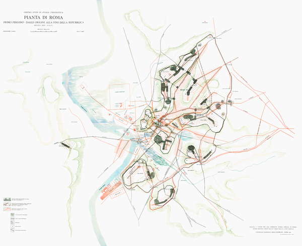
The maps reposted in this figure are by Muratori, S., Bollati, R., Bollati, S., Marinucci, G. (1963) and show the urban evolution of Roma from the early settlement to modern times; a) XIII-II centuries B.C.E.
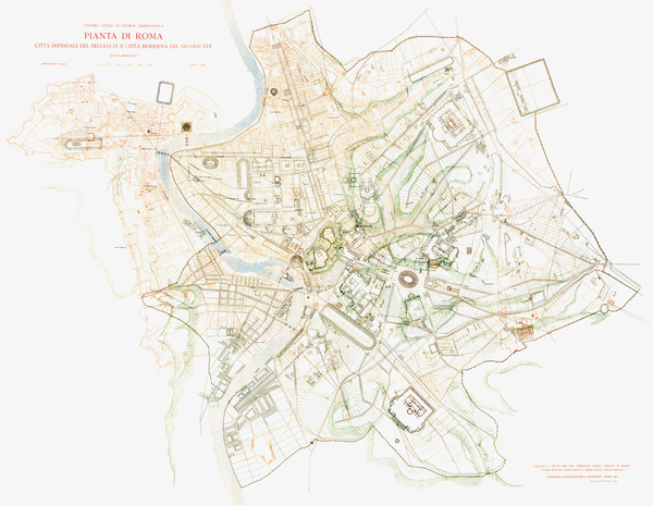
d) comparison of the city during the Imperial time in the IV century and the city in the XIX century
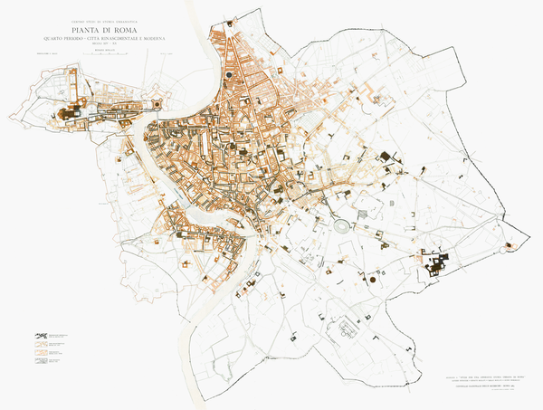
e) comparison of the city during the Renaissance time in the XV century and the city in the XX century
Overview on main geological hazards
Roma capital city is exposed to several geological hazards (Table 1), which are different as intensity, recurrence time and affected areas (Funiciello and Cologgi, 2008).
Table 1. Main Geological Hazards
| Hazards | recurrence times | areas affected |
|---|---|---|
| Subsidence | continuous process | alluvial areas (less in the city historical centre) |
| Landslides | 100 yrs | West flank of Tiber valley |
| Rock fall, roof collapses of underground tunnels | 2 yrs | East flank of Tiber valley and Colli Albani ignimbrite plateau |
| Floods | 30 yrs | alluvial plains |
| Extreme climatic events | 1 yr | ubiquitarian |
| Hurricanes, tsunamis | 1 yr | coast |
| Groundwater pollution and salinization | continuous process | ubiquitarian |
| Groundwater depletion | continuous process | ubiquitarian |
| Local amplification of earthquakes | 100/30 yrs | mostly alluvial plains |
| Gas emissions (CO2, H2S, Radon) | continuous process | Colli Albani area |
| Volcanic eruptions | 10,000 yrs | Colli Albani area |
Subsidence. The Tiber Holocene alluvial deposits downtown Roma are up to 60 m thick, filling the Wűrmian valley, which deeply cuts the Pliocene clay basement. The stratigraphy of the alluvial deposit is complex and locally depends on the paleocourse of the river and the presence and dimension of tributaries (Corazza et al., 1999; Campolunghi et al., 2008a). The stratigraphy is a fining upward sequence with a basal conglomerate overlain by sand, silt and clay with peaty levels. The succession is topped by 1-10 m of anthropogenic backfill. The sediments are unconsolidated and the topmost 20 m are the most prone to compaction, because of the fine grain-size and the presence of peat, which in many cases have produced severe to irreversible damages to buildings, such as the case of Via Giustiniano Imperatore (Campolunghi et al., 2008b). Over ten years of interferometric remote sensing data have revealed that buildings along the Tiber alluvial plain are subject to a general subsidence (Fig. 23). At the scale of the city areal subsidence is most evident away from the city centre. This is because downtown buildings and large structures have existed from more than 2000 years and sediments have already undergone to compaction, whereas the recent city is still loading up the alluvial sediments over which is built. This is demonstrated by the high values of resistance to penetration that shallow sediments show in the city centre.
Seismic hazard. The poor geotechnical characteristics of the alluvial sediments also determine anomalous ground acceleration during earthquakes, and differential shaking at the contact with the consolidated bedrock. Strong earthquakes from the Apennine region may produce significant damages, essentially within the Tiber river tributaries alluvial plains (Donati et al., 2008). Severe damages to monuments, such as the collapse of the Colosseum in 1349, are associated with this type of seismic events, whereas more limited and localised effects may be produced by the shallow seismicity of the Colli Albani volcano and the occasional seismicity of the Roma area (Rovelli et al., 1995).
Figure 23. The problem of subsidence
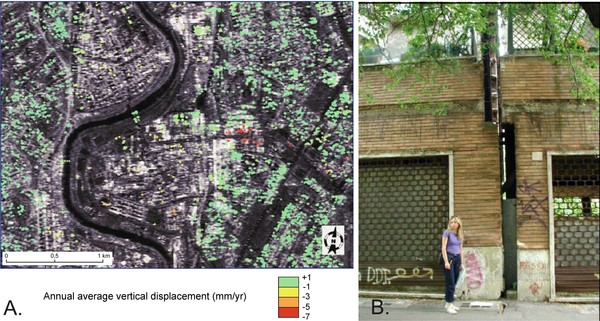
A. Estimate of vertical displacement of building from multi-image radar map analysis (from Giordano, Mazza et al., 2004). At present, several edifices built over unconsolidated clays are monitored from selective subsidence. This image is a courtesy of F. Ferrucci and has been obtained by comparing 10 years of satellite images. B. Evidence of differential subsidence on the structure of buildings.
The Colosseum was half built on the bedrock, there constituted by pre-volcanic conglomerate and sand, and half on the Fosso Labicano talweg; the contrast of seismic impedance between the bedrock and the unconsolidated sediments of the Fosso Labicano produced with times the main damages and partial collapses of the outer wall of the monument when in 1349 a strong earthquake in the Apennine region struck Roma (Funiciello et al., 1995). Experimental analogue and numerical modelling have shown that the resonance frequencies of both the monument and the alluvial sediments filling the Tiber river valley have the same value of 2 Hz. This coincidence explains why the shaking of the alluvial sediments produces an amplification of the shaking of the monument, and therefore damages (Fig. 24).
Figure 24. The Coliseum and the effects of local amplification of seismic waves
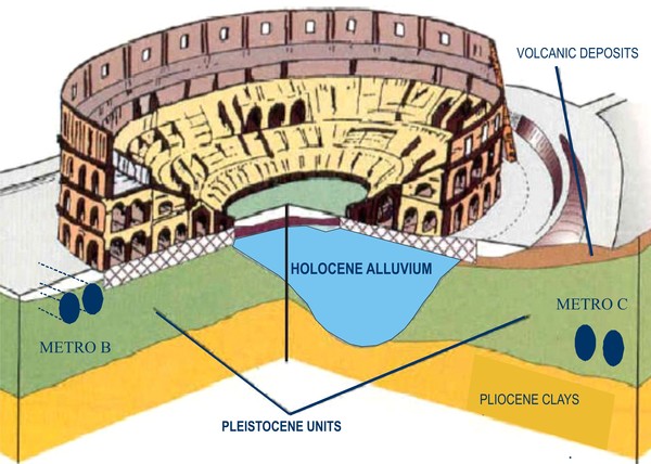
Block diagram of the Coliseum showing the underlying geology and the occurrence of unconsolidated Holocene alluvial deposits which have caused the collapse of half of the external walls due to differential shaking during the 1349 earthquake (Funiciello et al., 1995).
The recent introduction of the Roma municipality among those required to comply to anti-seisimic engeneering of new constructions (though, as appropriate, in categories with more limited requirements) is a great success of 20 years of geological studies, but does not solve the case of damaged buildings in the historic center of the City for which, especially for those on Recent alluvial areas, it should be considered to give urgent intervention to evaluate static conditions.
Rotational landslides are characteristics of the reliefs overlooking the Tiber valley associated with the Pliocene-Quaternary clay and sand of the Monte Mario-Gianicolo structural high (areas of Belsito, Monte Mario, Vatican Hill and the ridge Gianicolo-Monteverde; Amanti et al., 1995) (Fig. 25).
Figure 25. Landslides in Roma (I)
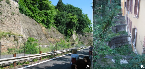
Landslides along the left side of the Tiber river valley, due to slow movement of the Pliocene clays . A. The external wall of Villa Sciarra collapsed in 1990. B. The edifices at the base of Monteverde hill have been built with horizontal arcs to prevent the effects of decompression of the overconsolidated Pliocene clays.
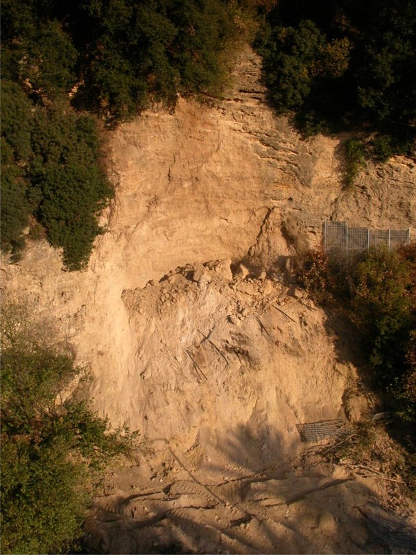
Rock-falls forms more frequently along the left flank of the Tiber valley, where the volcanic plateau is deeply cut through (Pincio hill, Capitoline Hill) and both lithoidal continental and volcanic Quaternary rock-formations are exposed along vertical cliffs dissected by fractures (Tufo Lionato, Valle Giulia travertines). These processes are very localized and may be enhanced by human interaction, such as the excavation of tunnels, such it was the recent case occurred along the western slope of the Monti Parioli, in December 2007 (Amanti et al., 2008) (Fig. 26).
The river floods have been one of the most damaging and dangerous natural processes for the city. The flow rate of the Tiber river system can increase in very short times from a few hundred to more than 2000 m3/sec, and every two hundred years it may reach exceptional values of up to 4000 m3/sec.
Extreme weather events are mainly represented by several consecutive days of rainfall typical of autumn and winter. Parts of the city where the underground drainage systems are not fully efficient and with very flat morphology are those subject to greater risk, as well as areas where dense constructions and diffused paved roads induce a severe land-impermeabilisation.
Embankments were built to protect the natural alluvial plain from floodings (Fig. 27) and the Tiber river has been progressively regimated with the construction of dams along its course. Floods since 1950 have reduced in number and intensity. The most remarkable side effect to the dam costruction is the dramatic reduction of solid transport of the Tiber, which is inducing a severe retreat of the coast and damages to the economy of the Roman shores (Praturlon, 2008), similar in magnitude to the progradations and regressions experienced by the Tiber river delta several times during the Holocene both for climatic variation and oversedimentation during volcanic activity of the Albano maar.
Hydrogeology. The construction of the embakments, underground infrastrucutres (metro lines, parkings etc.) and the backfilling of many tributaries within the urban area have drastically changed the local hydrogeology of Roma. Downtown the groundwater table has rose by metres because the natural drainage to the Tiber is obstacled by the embankments, interfering with the basements of many buildings, and worsening the geothecnical properties of the unconsolidated sediments. Frequent water losses from the underground aqueducts and surges also contribute to changing the local balance.
Figure 27. The 2009 flood in Roma
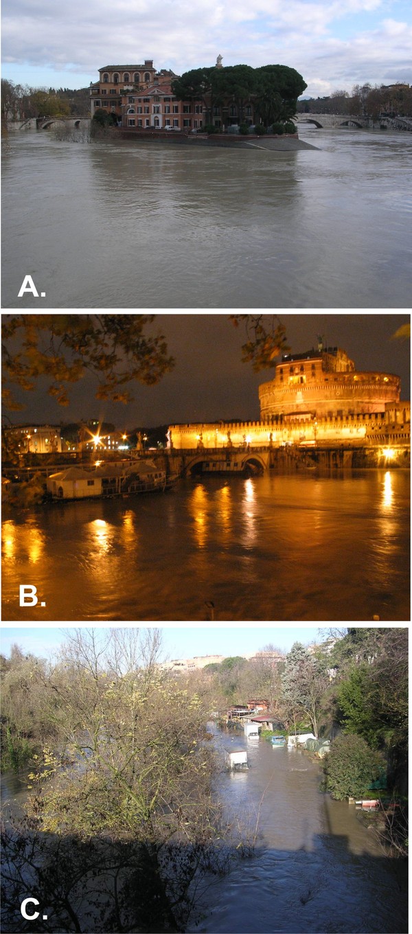
A. Tiberina island. B. Boats against S. Angelo Bridge. C. the flood along the Aniene River.
In the periphery of the city, by contrast, the dramatic increase of groundwater extraction has induced a drawdown of the water table by several tens of metres and up to 60 m, with a demonstrated subsidence in the areas most exposed to this problem (Capelli and Mazza, 2005). The coastal areas are subject to a progressive depletion and salinization of the aquifers with serious danger to the relevant local flora (pine forests and parks) and need for continuous monitoring (Capelli and Mazza 2008b).
Figure 28. Gas hazard associated to the quiescent Colli Albani volcano
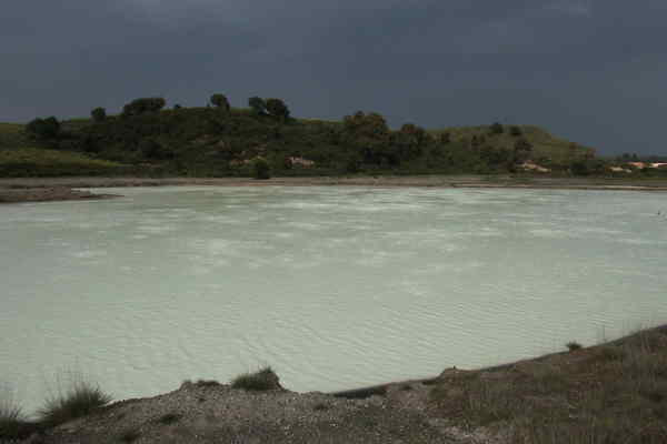
The lake near La Zolforata, is acidic for the upwelling of CO2 and H2S rich gas which pose serious hazard issues.
Parameters such as the effective infiltration has also drastically reduced by means of not pervious human fill of the urbanised areas, as much as the loading of unconsolodated terrains is also varying with time their permeability due to the ongoing compaction. All the above mentioned factors contribute to fastly change the local hydrogeology, i.e. the flow rates and the flow paths, as well as the volumes of rocks interested by groundwater flow.
Groundwater pollution is mainly local, but no less harmful as a consequence of uncontrolled discharges (waste oil, sludges etc.). It is ultimately the loss of a strategic resource that could, in the near future, be crucial to the city.
Gas Hazard. The proximity of Roma to the quiescent Colli Albani volcano, exposes several areas geologically and structurally prone to anomalous gas emissions (mainly CO2 and H2S and secondarily radon), especially to the southeastern outskirts of the city (Carapezza et al., 2003; 2010; Carapezza and Tarchini 2007) (Fig. 28). The gas hazard can be prevented by systematic requirements in construction (especially for underground environments) and presciptions for the execution of drillings, excavations and trenches in areas of potential hazard.
