Introduction
Although caught in between the steady-state relative convergence of the African and European continental landmasses, the Neogene history of Italy features smaller-scale orogenic segments where rapid thrust-belt motion, crustal thickening and back-arc thinning (Fig. 1) often overwhelmed the plate-scale signature (e.g. Carminati et al., this issue). Depending on the timescale of observation and on the appropriate analytical tool, however, modes and rates of deformation in individual crustal segments can be established with variable accuracy and precision. Tectonic events occurring at the million-yr timescales have left their record in the geological archive of Italy, and rates of orogenic belt migration are relatively well established using syn-orogenic deposits (e.g. Patacca and Scandone, 2007) or ancient erosional and depositional surfaces (e.g. Ferranti and Oldow, 2005) as markers. Similarly, the pattern of contemporary deformation is well depicted by seismicity and geodetic (e.g. Fig. 2; Barba et al., this issue; Devoti et al., this issue) analysis. Unfortunately, geologic and modern motions are not always reconciled with ease, a pitfall occurring almost everywhere in the world.
This limitation particularly downgrades efforts seeking to compare rates and patterns of horizontal tectonic motion. Although the geological pattern can be compared to horizontal motions derived from GPS geodetic velocities (e.g. Oldow et al., 2002; D’Agostino and Selvaggi, 2004; Serpelloni et al., 2005; Ferranti et al., 2008), the intervening time intervals from the 1 Myr to the present-day is left undisclosed, with fundamental drawbacks on understanding current geodynamic processes.
Fortunately, favourable outcrop conditions coupled to a long-lasting tradition of coastal studies in Italy has led to investigation of markers of ancient shorelines at several sites, covering the whole nation perimeter albeit with variable density. Appraisal of these paleo-geodetic markers occurrence in the context of the regional tectonic processes provides an unprecedented opportunity to assess and compare the extent, rate and duration of vertical tectonic displacements at what we may call the intermediate- (100 to 10 kyr BP) to short-term (10 to 1 kyr BP) timescales. In addition, the recent availability of high-quality geodetic data at costal sites (tide gauges and Global Positioning System, GPS, measurements) supplies a much needed snapshot on the contemporary pattern of deformation, provided that adequate corrections for non-tectonic effect are applied. Thus, information yielded from coastal tectonic analysis stands as vital in order to bridge the gap between events occurring at geologic (1 Myr) and contemporary timescales.
In this contribution, we deliver an overview of current vertical tectonic motions experienced by the nation coastline, mostly building upon studies carried by our group and by other researchers, to whom the reader is referred for detailed data analysis. Integration of morphotectonic, structural, geoarcheological and geodetic data is used to establish the appropriate spatial extent, rate and duration of vertical tectonic motion within individual crustal segments. What we are particularly interested in is to have clues on the timescale of rate changes by comparing intermediate and short-term rates in specific sectors. A second fundamental task is the search for different signals in the deformation pattern recorded by markers of past shorelines. Specifically, we are interested to establish whether the present position reached by these markers results from the aggregate contribution of processes operating at a regional or local scale (or both), and to stipulate the magnitude and spatial significance of each contribution. As a fundamental corollary, our analysis provides qualitative clues on the depth significance and driving mechanisms of deformation.
The paper is organized as follows. After a brief review of published studies on regional-scale relative sea-level (RLS) changes and coastal tectonics, we illustrate the intermediate and short-term pattern of deformation based on the Last Interglacial (Lig, 125 kyr BP) and Holocene (1-10 kyr BP) markers. Later on, we present instrumental (tide-gauge and GPS) approaches and observations on vertical displacement and RSL changes. These different datasets are blended together in the discussion chapter.
As this review will show, we found that regional tectonic processes are substantially halted in the central and northern Tyrrhenian Sea margins, but local mechanisms continue to operate. Differently, the pattern of displacement in the Calabrian arc highlights the contribution of both regional and local processes to deformation. The finding of recent changes in deformation rates in Calabria, which is possibly accommodated by a large part of the local structures mapped or inferred in the on-land territory and offshore, allows to understanding the appropriate time-scale of changes in stick-slip motion. A third instructive case history is represented by the northern Adriatic Sea margins, where no rate changes have occurred at the regional scale, suggesting that major geodynamic processes are controlling the deformation pattern.
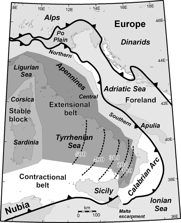
Figure 1. Major tectonic domains of Italy
Adriatic foreland, contractional and extensional belts, and stable block, indicated by light grey, white, dark grey and medium grey, respectively (slightly modified after Antonioli et al., 2009). Dashed lines in southern Tyrrhenian sea indicates the depth (in km) of the Benioff zone (Giardini and Velonà, 1988; Selvaggi and Chiarabba, 1995).
It is not superfluous to note that accurate and precise determination of intermediate- and short-term markers of deformation is of paramount importance in active orogens with relatively low displacement rates, such as those encountered in the Central Mediterranean Sea (Devoti et al., this issue). Although historic observations and instrumental data are of prime quality in Italy, they have still limited capability of capturing the entire extent of cyclic deformation processes such as seismicity. On the contrary, coastal tectonic analysis may provide vital information on the seismic cycle for particular areas or structures and the relative role of seismogenic versus regional processes, with profound implications on seismic potential determination.
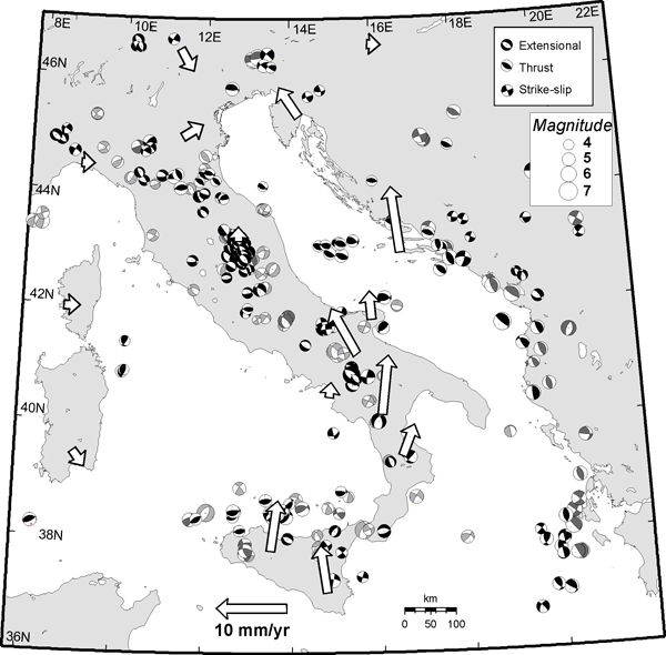
Figure 2. Active deformation in Italy.
Beach-balls are focal solutions of M>4 earthquakes (black: 1976-2004 Harvard - http://www.seismology.harvard.edu/CMTsearch.html - and 1997-2004 Mednet - http://mednet.ingrm.it/ - CMT catalogues; light grey: Gasparini et al., 1985; medium grey: Anderson and Jackson, 1987). Arrows are generalized GPS velocities with respect to stable Europe (Oldow et al., 2002). Depth of the Ionian slab as in Fig. 1.