Meso-Cenozoic Stratigraphical Setting of Central Italy
Introduction
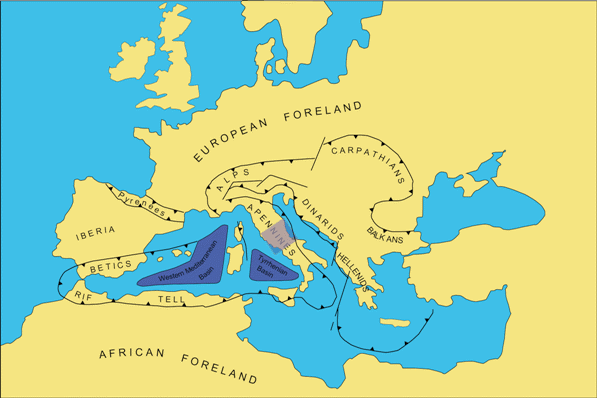
The central Apennines are a part of the peri-Mediterranean orogenic belt (Fig. 1) built up mainly in Neogene times as a consequence of the collision and the convergence between the European and African macroplates. This section summarizes stratigraphical analyses of Meso-Cenozoic carbonates and Miocene terrigenous deposits cropping out in the central Apennines.
In the past 40 years, several studies have investigated the Meso-Cenozoic deposits of central Italy. The analytical papers on the stratigraphical features of the central Apennines, published in the 1960-70's (Accordi, 1964; Angelucci, 1966; La Monica, 1966; Accordi et al., 1969; Devoto, 1969; Centamore et al., 1971; Parotto, 1971; Parotto and Praturlon, 1975) have been followed, in the 1980-90"s, by the first attempts to define the geodynamical significance of the local Miocene stratigraphical record (Royden et al., 1987; Patacca and Scandone, 1989; Santo and Sgrosso, 1987; Boccaletti et al., 1990; Centamore et al., 1991; Roure et al., 1991; Patacca et al., 1992a, 1992b; Casero et al., 1992; Cipollari and Cosentino, 1993, 1995, 1996; Sgrosso, 1988, 1992a, 1992b; Zoetemeijer et al., 1993).
The Meso-Cenozoic stratigraphical successions that crop out in central Italy (Fig. 2) are part of the sedimentary wedge developed on the southern Neotethyan passive margin. On the previous Late Triassic shallow-water carbonate platform, a basin-platform system developed in the area as a consequence of a rifting stage that affected the whole Neotethyan region during the Middle Liassic (Castellarin et al., 1978, 1984; Ciarapica and Passeri, 1998, 2002). The palaeogeography related to the Middle Liassic basin-platform system was persistent until early Tertiary times.
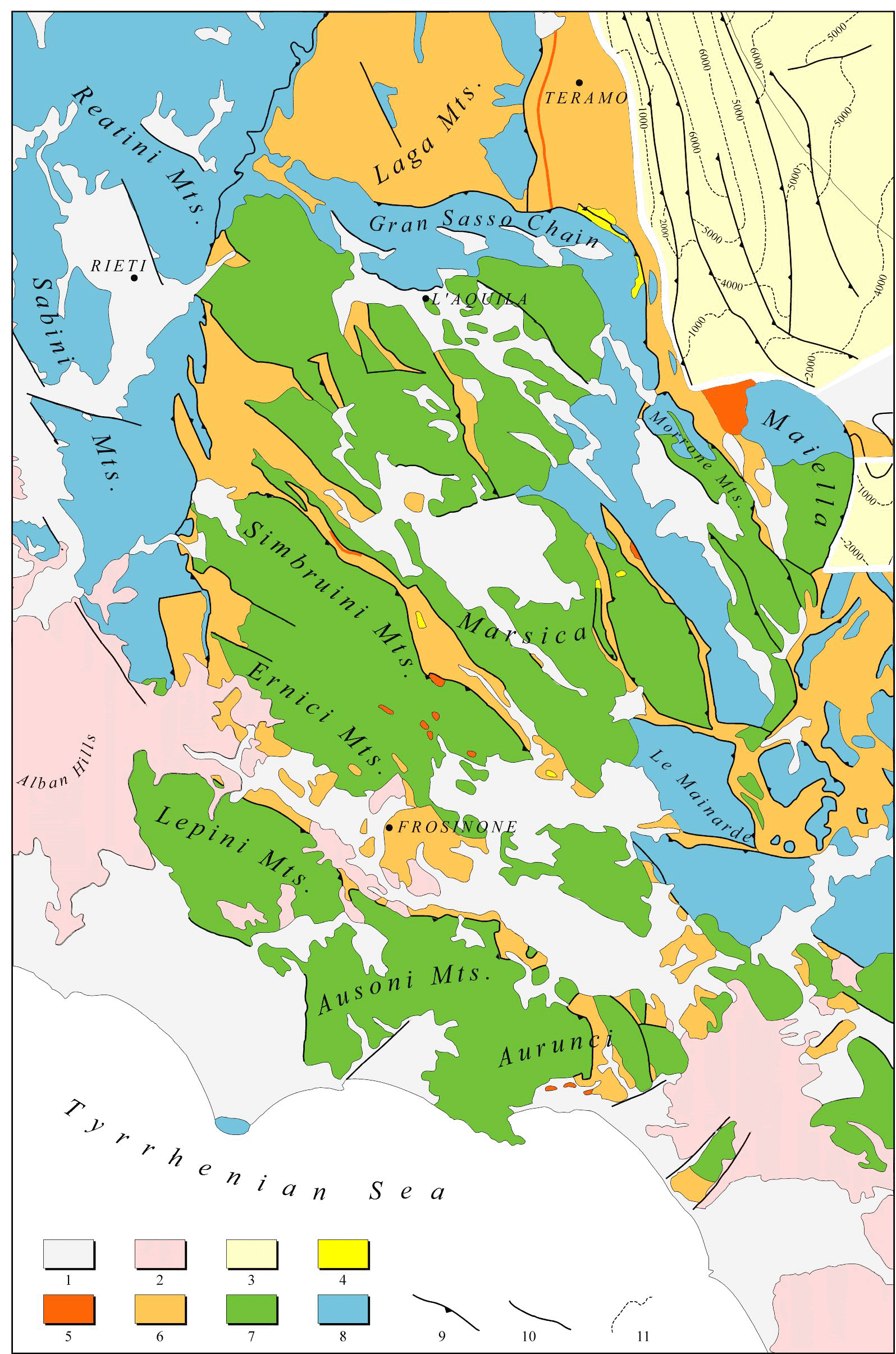
Figure 2. Structural sketch map of the central Apennines

Structural sketch map of the central Apennines. 1) Plio-Pleistocene marine and continental deposits; 2) Pleistocene volcanics; 3) buried Pliocene marine sediments; 4) clastic deposits related to the Messinian Lago-Mare/Early Pliocene thrust-top basins; 5) Messinian clastic deposits and evaporites; 6) foredeep siliciclastic deposits of undifferentiated age (Upper Miocene); 7) Meso-Cenozoic shallow-water limestones; 8) Meso-Cenozoic deep-water limestones; 9) thrust; 10) undifferentiated fault; 11) isobaths in meters of the base of the Pliocene deposits.
Seafloor depth variations of Miocene sediments reflect the distribution of preexisting carbonate platforms and adjacent pelagic basins. The palaeobathymetrical differences led to sedimentation with mainly pelagic cherty limestones (Bisciaro Fm) and spongolitic marls (Guadagnolo Fm) on top of a Meso-Cenozoic pelagic sequence (Civitelli et al., 1988), whereas above the earlier carbonate platforms, Middle Miocene shallow water calcarenites were deposited unconformably or paraconformably on Cretaceous limestones ("Paleogene hiatus"). This "Paleogene hiatus" is well documented in the shallow-water Meso-Cenozoic stratigraphic sequences (Selli, 1957; Accordi, 1964; Devoto, 1969; Accordi et al., 1969; Parotto and Praturlon, 1975; Accordi and Carbone, 1986; Bonardi et al., 1988; Bigi et al., 1992; Damiani et al., 1992). Damiani et al. (1992) proposed two alternative explanations for this hiatus: 1) subaerial erosional processes; or 2) no sedimentation in a submarine environment. However, no explanations were provided for the causes of the erosional processes and/or non-depositional events. A model suggesting an intraplate stress to explain the "Paleogene hiatus" has been proposed by Cipollari and Cosentino (1995).
During the late Miocene, the central portion of the Apennine palaeogeographical domain was involved in the evolution of a post-collisional orogenic system, consisting of a thrust-belt/foredeep couple migrating toward more external domains (Bally et al., 1988; Mostardini and Merlini, 1988; Patacca and Scandone, 1989; Patacca et al., 1992a; Casero et al., 1992; Cipollari and Cosentino, 1995, 1996). In this geodynamical setting, tectonically-controlled sedimentary basins were developed (i.e. foredeep and piggyback basins).
Facies Distribution of the Pre-Orogenic Stratigraphical Successions
Triassic-Lower Liassic
During the late Triassic, a rifting stage affecting the southern margin of the Neotethyan domain gave rise to an intra-platform trough with deeper-water sedimentation. Upper Triassic-Lower Liassic deposits crop out in few central Apennine localities, particularly in those areas characterized by marginal platform or transitional towards pelagic Meso-Cenozoic successions. In fact, the outcrops of Triassic-Lower Liassic are rare in those areas that are characterized by Meso-Cenozoic carbonate platform facies [Simbruini Mts, Matese Mts (Plate 1)].
The majority of the Triassic outcrops in central Apennines belong to epeiric shelf or carbonate platform palaeoenvironments. The facies associated with these two sedimentary shallow-water environments are presently found in the Umbro-Sabine, Latium-Abruzzi and Matese Mts sectors. Currently, the Olevano-Antrodoco thrust brings the epeiric shelf area (W of the tectonic line) in sharp contact with the carbonate platform area. However, Triassic facies related to platform margin or euxinic basin domains are also known. Such depositional patterns have been found in the Triassic succession of Gran Sasso d"Italia (Norian-Raethian bituminous dolostones, Vradda) and, farther south, in the succession of the Simbruini Mts (Noric-Raethic bituminous dolostones of Filettino) (Plate 2). In both sectors, inside the Triassic succession, lateral facies variations occur, showing a transition from a carbonate platform environment towards an euxinic basin through carbonate platform margin facies (Adamoli et al., 1990; Damiani et al., 1992; Cirilli, 1992; 1993). The bituminous dolostones of Mt Prena and Vradda (Gran Sasso d"Italia) and those cropping out at Filettino (Simbruini Mts) are related to sedimentation in euxinic basins. The same heteropic trend visible in the Grand Sasso area (Bigazzi et al., 1992) occurs in the Simbruini Mts. There, carbonate platform facies in the west transition eastward to euxinic basinal facies through buildups and bioclastic facies (Cirilli, 1993).
In the subsurface of central and southern Italy, Triassic facies similar to those cropping out at Filettino and in the Gran Sasso chain have been found in the Emma (Adriatic offshore) and Noto-Streppenosa (Iblean and Iblean offshore, Sicily) basins. The limited available data do not allow more than a simple comparison between the bituminous deposits of Filettino and Gran Sasso. Those deposits could be related either to the same pelagic sedimentary basin or to different intra-platform troughs. Depositional relationships are similarly ambiguous for the bituminous dolostones of Mt Prena-Vredda (Gran Sasso chain) and for those drilled in the Adriatic offshore (Emma basin) (Zappaterra, 1992). At present, there is no clear evidence that they were deposited in the same Triassic basin. Taking into account the shortening of the Apennine chain, the Triassic basin should have been considerably wide. Regardless of their precise configuration, the presence of these intra-platform troughs and/or true Triassic basins can be related to the earliest rifting phases which, during Jurassic time, lead to the formation of the Neotethys oceanic basin.
During the Early Liassic, the palaeogeography was roughly the same as in the previous time interval, with a wide domain of shallow-water platform controlling the sedimentation in this southern portion of the Neotethys margin, except for the Filettino (Simbruini Mts) and Mt Prena-Vredda (Gran Sasso chain) areas, which continued to be characterized by pelagic sedimentation [Filettino breccias and Sant'Antonio Fm, Hettangian-Sinemurian, in the Filettino area, Calcari maculati and Corniola selcifera, Hettangian-Sinemurian, in the Vradda sector (Damiani et al., 1992)].
Middle Liassic-Lower Cretaceous
The Middle Liassic tectonic phase affected the whole Neotethyan domain, as is evident in the Mesozoic successions of central Italy. This tectonic phase, which in the study area shows a clear extensional character, is related to the Neotethys Jurassic rifting. From a more regional point of view, some authors (e.g., Abbate et al., 1994; Ziegler and Roure, 1996) suppose that it was induced by the transform motion of some important tectonic elements, which should have affected and constrained the expansion of the inner Ligure-Piemontese oceanic basin.
In all the peri-Neotethyan sectors, this tectonic phase generally showed an extensional character and induced variations in the sea-floor depth. This initiated sedimentary basins characterized by different bathymetry, sedimentation, subsidence, etc.
In central Italy, as well as in all those sectors that during the Early Jurassic were located along the passive continental margin of the expanding Neotethyan basin, this Middle Liassic tectonic phase broke up the shallow-water platform domain that was widespread in the whole central Italy during the Early Liassic (except for the Filettino and Vradda sectors). These extensional tectonics created platform-basin systems, characterized by downthrown sectors dominated by deeper-water sedimentation (pelagic successions) with local clastic carbonate sediment coming from the shallower areas, and upthrown sectors with shallow-water carbonate deposits related to shallow-water platform environments.
This new extensional event, which was related to the early stage of the Neotethys rifting, did not happen only along the trend of previous extensional structures, but, also along extensional fault systems perpendicular to the Late Triassic tectonic features. Following this tectonic event, the margins of the Jurassic-Cretaceous carbonate platforms were defined as well as the transitional zones between them and the downthrown areas. In addition to platform margins with N-S present orientation, the present-day distribution of the Jurassic-Cretaceous facies of central Italy shows north-south lateral facies variations in several places, including the northern margin of the Grand Sasso, the northern margin of the Maiella Mts, and the northern margin of the Morrone Mts. The presence of huge volumes of resedimented carbonate in the Middle Liassic deposits of the transitional areas (basin-to-platform) (Corniola Fm with megabreccias) is a further stratigraphical signal of the tectonic event responsible for creating the widespread pelagic domain.
Plates 1 and 2 show the Mesozoic successions of central Italy split into four main facies: 1) basin; 2) basin-to-platform; 3) platform edge; and 4) platform. The distribution of the platform edge facies and of the transitional one (basin-to-platform facies) shows a clear platform-basin system that controlled the Mesozoic sedimentation in the area (Fig. 3).
The palaeogeographical setting of this system generated the pelagic sedimentation of the northern Sibillini Mts, the inner Umbria arch, the Martani Mts, and the Narnesi-Amerini Mts. The stratigraphic succession of this domain is the Umbro-Marche Liassic basin sequence, characterized by limestones and marly pelagic limestones, without any evidence of significant carbonate re-sedimentation (Fig. 4). The rare resedimented units are linked to local morpho-structural Jurassic palaeo-highs, characterized by reduced or condensed Jurassic sequences (Pelagic Carbonate Platform - PCP, Figs. 3, 4).
Figure 3. Platform-Basin system
Main steps of the Late Triassic- Middle Miocene evolution of the platform-basin system in central Italy (modified from Accordi and Carbone, 1986). CP – carbonate platform; PCP – pelagic carbonate platform; 1) evaporites; 2) dolomites and laminated dolomitic limestones; 3) clays and marls with intercalations of oolitic and organogenous wackstone-grainstone; 4) marls; 5) bioclastic wackstone-packstone; 6) mudstone with biodetritic and microclastic intercalations ; 7) marls, clays and pelagic micrites; 8) pelagic mudstone-wackstone and hardground with nodular structures; 9) carbonate platform limestones; 10) organogenous grainstone-rudstone; 11) packstone-grainstone with intercalations of marly pelagic mudstone; 12) organogenous wackstone-grainstone; 13) carbonate basement; 14) supratidal deposits and alteration soils.
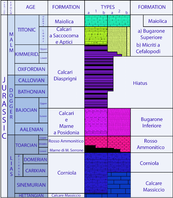
Figure 4. Jurassic stratigraphy of Umbria-Marche domain
Jurassic stratigraphy of the Umbria-Marche basin. The presence of hiatuses in the succession characterizes the stratigraphy of the Jurassic morpho-structural highs (seamounts) (after Cresta, 1989).
The early Cretaceous regional paleogeography was quite similar to that of the late Jurassic. The early Cretaceous southern margin of the Neotethyan Ocean was characterized by a persistent platform-basin system. In this time interval, to the west of this platform-basin system, the Ligurian-Piedmont oceanic basin stopped spreading. The platform-basin system led to the deposition of thick shallow- and deeper-water carbonate successions.
The low naphtagenic potential of these carbonate successions is confined to its upper portion. Lower in the stratigraphic sequence, near the stratigraphical transition between the micritic limestone with radiolarians and tintinnides pertaining to the Maiolica Fm and the overlying Marne a fucoidi Fm, the beginning of an euxinic event is recorded over the whole basin, responsible for the sedimentation of clayey horizons rich in organic matter (black-shales). The stratigraphical level that bears a particularly high concentration of these black-shales is less than a few metres thick (Livello Selli) and comprises also the basal part of the Marne a fucoidi (Erba et al., 1989).
In the Marne a fucoidi Fm cored in the Piobbico well, 154 centimeter- and millimeter scale black-shale levels have been observed. The thickest (1-3 metres) highly Corg-rich black-shale occurs in the lower part of the Marne a fucoidi Fm ("Livello Selli"). In the middle portion of the Marne a fucoidi Fm, two thick (20 cm) and highly Corg-rich black-shales are recorded and named "Livello n°113" and "Livello Urbino" (Coccioni et al., 1987). These three distinct anoxic events are marker-beds throughout the Umbria-Marche basin and can be correlated to coeval anoxic episodes in the Neotethys (Sicily, Gargano, Southern Alps, etc.). Generally, the total thickness of the Marne a fucoidi Fm is no more than 85 m.
Moving towards SE from the sectors characterized by outcrops of the pelagic facies, there is a narrow strip, extending from the southern Sibillini Mts through the Reatini and Sabini Mts, and as far as to the Tiburtini Mts, in which a carbonate basin-to-platform succession crops out. This succession is characterized by frequent re-sediments of shallow-water carbonates within pelagic calcareous and marly-calcareous deposits. Also along this strip, reduced or condensed Jurassic successions are common, and are related to pelagic carbonate platforms (PCP, Santantonio, 1993; Galluzzo and Santantonio, 2002; Cosentino et al., 2006). Basin-to-platform facies, similar to those previously described, are present along the whole Gran Sasso chain, along the Mt Genzana-Mt Greco ridge, and in the Monti della Meta. Basin-to-platform facies are also exposed through drilling in the Frosolone 2 well.
The outcrops of lithofacies associated with the platform edge environment are rare and confined to the Montagna Grande ridge, Montagna del Morrone, some places in the Mt Velino-Mt Magnola-Mt Sirente region, and along the Mt Giano (Antrodoco) ridge. These lithofacies mainly consist of either organogenic grainstones with echinoderms, algae, corals and mollusks (patch reef environment), or micritic limestones that are sometimes laminated, and fossiliferous grainstones (algal-ridge environment).The carbonate facies related to shallow-water platform environments are widely distributed along the carbonate ridges of the Latium-Abruzzi region. They crop out in the Lepini Mts, Ausoni Mts, Aurunci Mts, Simbruini Mts, Ernici Mts, Mt Cairo, Matese Mts, Caserta and Benevento Mts, Mt Nuria, Mt Velino, Mt Sirente, Marsica Mts, Morrone Mts, Mt Porrara, Mt Pizzalto, Mt Rotella, and Maiella Mts. The prevailing lithofacies, associated mainly with open shallow-water platform or restricted shallow-water platform environments, are made of dolostones, dolomitic limestones and micritic limestones. In the basal portion of this interval, grainstones with oolitic intercalations are present. The upper portion (Aptian) is generally characterized by alternating micrites, marly limestones, and finely stratified marls (Marne a Orbitolina Fm).
Upper Cretaceous
The distribution of the different upper Cretaceous lithofacies is broadly similar to that of the previous time interval. In the lithofacies map (Plate 1), the basin and basin-to-platform successions correspond to the Upper Cretaceous-Oligocene time interval.
The successions related to a pelagic basin environment crop out widely from the northern Sibillini Mts to Mt Subasio, Martani Mts and Narni Mts. The prevailing lithotypes of this basinal succession are marly limestones, calcareous marls (Scaglia Fm) and, in the upper part of the stratigraphical interval, clayey marls (Scaglia cinerea Fm).
In the basal portion of the stratigraphic interval (Late Cenomanian) the basinal succession is characterized by an euxinic horizon ("Livello Bonarelli"), recognized throughout the basin as a potential source rock in this stratigraphic interval. The "Livello Bonarelli", ranging from 45 to 200 cm thick, consists of black limestones, argillites, gray-greenish radiolarian-rich siltstones, and black-shales rich in organic carbon. The black limestones often contain some well preserved fish remains. The "Livello Bonarelli" generally lies about 6-8 m below the boundary between the Scaglia bianca Fm and the Scaglia rossa Fm (Paris et al., 1989). The "Livello Bonarelli" has been split into three segments on the basis of its lithological characteristics:
- a lower segment consisting of brown to gray radiolarian-rich silts, whose thickness varies between 30 and 100 cm;
- a middle segment consisting of laminated black-shales rich in organic matter, whose thickness varies between 30 and 100 cm;
- an upper segment consisting of radiolarian-rich silts and gray-green sapropelites, whose thickness varies between 10 and 30 cm.
The "Livello Bonarelli" is an important marker horizon in the whole Tethyan Basin and can be correlated with the second Oceanic Anoxic Event (OAE defined by Schlanger and Jenkins, 1976).
Towards the SE is the boundary from the basin facies to the basin-to-platform facies, which widely characterize the Sibillini Mts, Reatini Mts, Sabini Mts, and Prenestini Mts. Similar facies border the carbonate platform of Mt Nuria, Mt Ocre, Mt Sirente, and Marsica Mts from the N and E.
Basin-to-platform facies belonging to the Late Cretaceous-Oligocene have been recognized at La Meta-Mainarde, Venafro Mts, Montagnola di Frosolone, and in the northern portion of Maiella and Morrone Mts. As in the basinal facies, an anoxic level corresponding to the "Livello Bonarelli" occurs in the lower part of this time interval in the basin-to-platform succession. This marker-bed is easily visible in the Sibillini Mts, Reatini Mts, and Sabini Mts.
The prevailing lithologies of this basin-to-platform facies are marly limestones, calcareous marls, and clayey marls, with frequent intercalations of mainly channelized bodies of re-sedimented carbonates of different grain size. These carbonate re-sediments show grain- and debris-flow depositional mechanisms.
The Upper Cretaceous-?Paleocene facies of platform edge are very rare. These facies crop out in the Mt Giano-Mt Gabbia area, SE of Piana dell"Aquila, Montagna Grande, La Meta, and Maiella Mts. Moreover, small outcrops are present at Rocca di Cave (Prenestini Mts) and Cori (Lepini Mts).
The lithofacies pertaining to the platform edge are characterized by cyclic alternations of packstones and grainstones with subordinate wackstones. Rudists, gastropods and hydrozoan are present.
The Mt Nuria-Mt Velino, western Marsica, Simbruini Mts-Ernici Mts-Mt Cairo, Lepini Mts-Ausoni Mts-Aurunci Mts, and Matese Mts expose wide outcrops of the Upper Cretaceous-?Paleocene platform succession. This succession is characterized mainly by dolomitic limestones, dolostones and wackstone, light- or hazel-brown in color, with fragments of hippurites and benthic foraminifers that generally record a restricted shallow-water platform environment.
Cenozoic
The Cenozoic pre-orogenic successions are related to a palaeogeographic framework slightly different from that of the basin-platform system that characterized the sedimentation during the Mesozoic. Whereas the basin and the basin-to-platform domains persisted throughout the Oligocene, the Mesozoic platform edge and platform domains were characterized, during Cenozoic, by a shallow ramp palaeoenvironment. Small, not mappable outcrops belonging to this shallow ramp Paleocene-Oligocene palaeoenvironment are present in Marsica, while a wider exposures characterize the southern margin of the Maiella Mts. Generally, they are made of grainstones and rudstones with corals, large foraminifers, red algae, and rudist debris.
During the Early Miocene, the lithofacies were further homogenized. In central Italy, only pelagic, transitional and shallow-water facies are present. Generally, the pelagic facies consists of marls and calcareous marls with chert and planktonic foraminifera, which laterally transition to marls and calcareous marls with frequent grain-flow or debris-flow carbonate re-sediments.
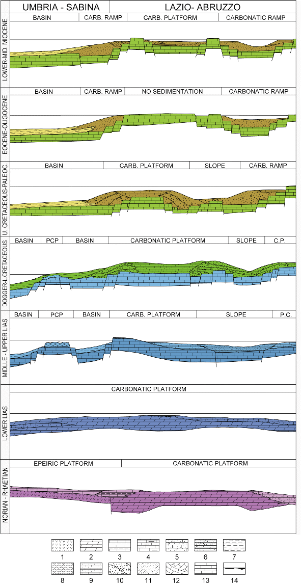
During the Middle Miocene, moving from the alignment Sibillini Mts-Reatini Mts-Sabini Mts-Prenestini Mts toward E, two lithofacies were developed: calcarenites with pelagic and displaced benthic fauna characteristic of a deeper carbonate ramp environment, and fine packstones and grainstones with essentially benthic fauna associated with a shallow carbonate ramp environment. Generally, on the Mesozoic platform domain the Middle Miocene shallow ramp deposits lie on the ?Palaeocene/Upper Cretaceous shallow-water carbonates. In contrast, in the Mt Sirente-Mt Turchio-Mt Rapanella area, the Middle Miocene shallow ramp deposits lie directly on the Lower Cretaceous shallow-water limestones of the Mesozoic platform domain, above the Paleogene hiatus (Fig. 5).
The Paleogene hiatus has been explained as due to an increase of the intraplate stress during the Middle Eocene collisional event between Adria and the European plate (Cipollari and Cosentino, 1995). This major tectonic event caused lithospheric folding and compressional deformation, and subsequent erosion in shallow-marine environments (i.e. carbonate platform domains).
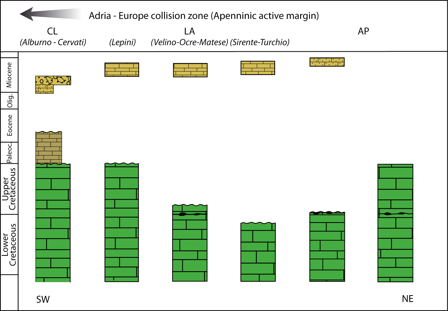
Figure 5. Chronostratigraphic diagram of the Paleogene hiatus

Chronostratigraphic diagram of the Adria carbonate-platform domains along an ideal palinspastic SW-NE transect in Central-Southern Italy. The diagram shows both the maximum gap in the eastern margin of the Latium-Abruzzi carbonate platform (LA, Sirente-Turchio area) and decreasing gap towards the Adria-Europe collision zone (SW). Data from Accordi and Carbone, 1986; Bonardi et al., 1988; Santo and Sgrosso, 1987; Sgrosso, 1992b.
Pre-orogenic palaeogeographical models
A tectonically high, active area such as the peri-Mediterranean poses many difficulties to deriving a detailed palaeogeographical model of the region. Many factors, including relatively recent orogenic processes, new oceanic basin formation, and lithospheric block rotations, impacted the evolution of the area in a number of ways that are generally not completely known.
In such a complex tectonic framework, the original relations of facies heteropy among contiguous sedimentary domains are generally obscured by tectonic activity. Reconstructing the pre-deformational palaeogeography of those areas requires unraveling its kinematic evolution and quantifying the amount of shortening and/or extension during the deformational processes. Despite uncertainties associated with these tasks, some palaeogeographical models for the western Tethyan realm have been reconstructed (Dercourt et al., 1993, Ciarapica and Passeri, 1998, 2002) taking into account almost all the parameters that could influence a palaeogeographic reconstruction, including a palinspastic restoration of the area that must consider the magnitude of tectonic deformation that affected the area.
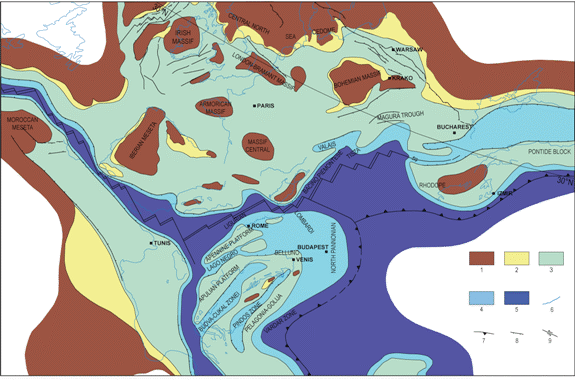
• Late Triassic palaeogeographical model of the peri-Mediterranean area.
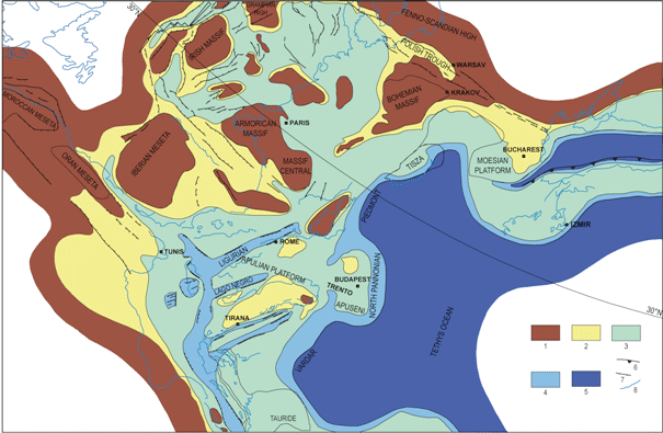
During the Late Triassic the present-day peri-Mediterranean area was located between 10° and 30° N latitude and was represented by a wide area of shallow-water platform that divided two huge continental emerged areas: the Iberic-Provençal sector of the central Europe to the north and the North-African sector to the south (Fig. 6). Towards the west, this wide shallow-water platform (SWP) region was affected by evaporitic sedimentation (evaporitic platform), whereas the remaining portion of the SWP was an epeiric platform. Some stratigraphical features allow further differentiation of the shallow-water platform environment into open SWP, evaporitic SWP, and restricted SWP (Plate 1). An initial Latest Triassic rifting caused the break up of what must have been a single huge carbonate sedimentation domain during the Early and Middle Trias. Following this rifting phase, the pre-existing Lagonegro trough (trending about E-W) began to expand, giving rise to the Sicanian Basin, to the Budva Trough, and to the Pindos-Olonos Zone. Moreover, some N-S lateral branches opened, forming basins affected by pelagic sedimentation: Emma Basin and Bosnia Basin.
Figure 6. Late Triassic paleogeographic map
Late Triassic paleogeographic map of Tethys realm (modified from Yilmaz et al., 1996). 1) continental; 2) coastal plain; 3) shelf deposition; basin and slope; 5) deep ocean; 6) volcanic; 7) overthrust; 8) strike-slip fault; 9) extensional fault; 10) coastline.
As described in the previous paragraphs, during the Late Triassic, pelagic facies (bituminous dolostones of Vradda and Filettino) existed in central Italy, similar to those that, in the Adriatric offshore, characterized the Emma Basin. Whereas it is possible that the bituminous dolostones of Vradda belong to the Emma Basin (mainly due to the proximity of the areas), it is more difficult to consider the bituminous dolostones of Filettino as pertaining to the same basin because the Triassic rocks that crop out at Venafro Mts and Matese Mts are related to shallow-water carbonate platform facies. The bituminous dolostones of Filettino could be the result of the tectono-sedimentary evolution of an intra-platform through, similar to the one associated with the Emma Basin but parallel to it and located in a more western sector, within the Apennine carbonate platform.
Farther north, an additional intra-platform through divided the shallow-water carbonate facies from the dolomitic domain.
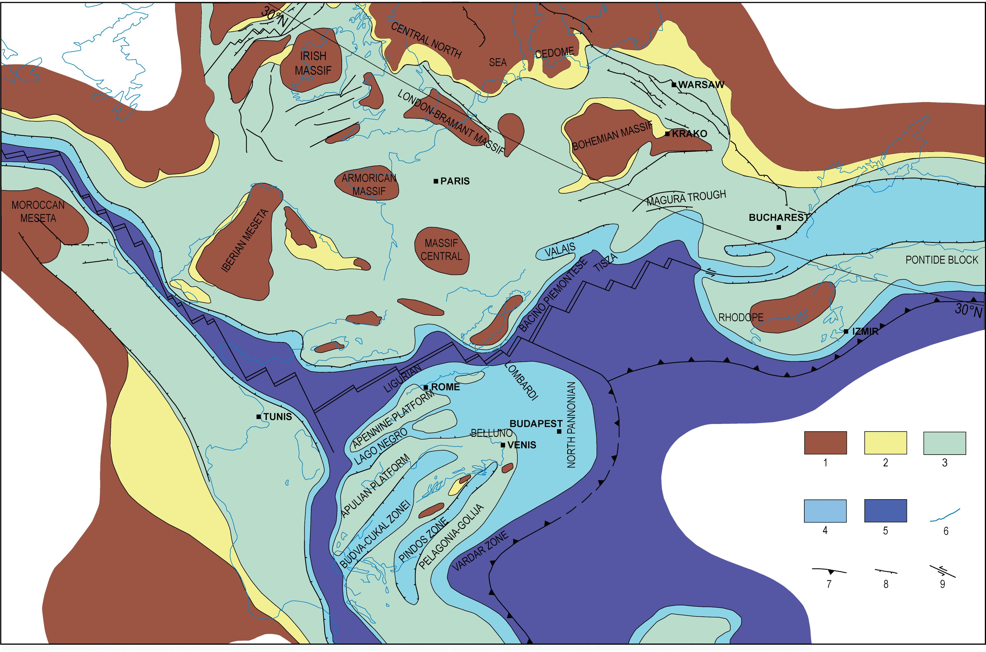
• Late Jurassic palaeogeographical model of the peri-Mediterranean area
As already discussed in the previous paragraphs devoted to the stratigraphical setting of central Italy, an important extensional tectonic phase occurred during Middle Liassic, which broke up the wide, shallow-water platform that during the infra-Liassic characterized the palaeogeographical setting of the present-day peri-Mediterranean area (Fig. 7). This extensional tectonic episode is strictly linked to the western propagation of the continental rifting that previously (Late Triassic) affected the more eastern regions of the present-day peri-Mediterranean area (Pindos-Olonos Zone).
Due to the extensional tectonics during the Late Jurassic, the platform-basin systems were widely developed and persisted throughout the Mesozoic. From the Middle Liassic, the shallow-water platforms of the peri-Tethyian area developed under epi-oceanic conditions. In this geodynamic framework, the Apulian platform became differentiated and subsequently isolated from the other Mesozoic epi-oceanic platforms, due to the development of confining pelagic basins such as the Sicily Basin, the Molise Basin and the Ionian Basin. The Molise Basin and, farther west, the Lagonegro Trough, divided the Apulian and Apennine platforms. Towards the north and west, the Apennine platform was linked, through the bacinal facies of Sabina, Tuscan Basin and Sicilide Basin, to true oceanic environments (Ligurian basin). This time interval records the maximum development of the Ligure-Piemontese oceanic basin, with the formation of sectors characterized by oceanic lithosphere.
Figure 7. Late Jurassic paleogeographic map
Late Jurassic paleogeographic map of Tethys realm (modified from Yilmaz et al., 1996). 1) continental; 2) coastal plain; 3) shelf deposition; basin and slope; 5) deep ocean; 6) volcanic; 7) overthrust; 8) strike-slip fault; 9) extensional fault; 10) coastline.
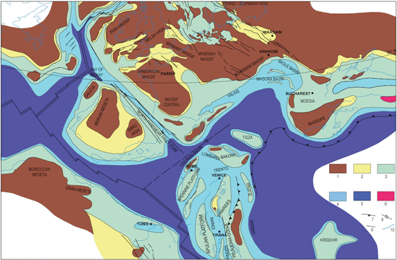
• Top Early Cretaceous palaeogeographical model of the peri-Mediterranean area
During the Late Cretaceous, the geodynamic processes controlling the peri-Mediterranean area underwent drastic changes. The dominant action of the extensional tectonics, which characterized the previous time-interval, persisted only in the more eastern sector of the peri-Mediterranean area (Lybian Basin and Cyprus Basin), while the more northern one was affected by compressional tectonics (Fig. 8). In the previous period, compression had already been active only in the more eastern sector of the peri-Mediterranean area (Vardar Zone). During this time interval, a general regressive trend was recorded on the northern margin of the peri-Mediterranean area, while the central sector underwent a period of relative tectonic rest. Thus, the evolution of the platform-basin systems that were first developed during the Middle Liassic extensional tectonic phase continued in this time interval. At that moment the southern margin of the peri-Mediterranean area was affected by a general trasgressive trend, which allowed for the spread of shallow-water platform environments across the southern sectors.
Figure 8. Early Cretaceous paleogeographic map
Early Cretaceous paleogeographic map of Tethys realm (modified from Yilmaz et al., 1996). 1) continental; 2) coastal plain; 3) shelf deposition; basin and slope; 5) deep ocean; 6) volcanic; 7) overthrust; 8) strike-slip fault; 9) extensional fault; 10) coastline.
Distribution of the Syn- and Post-Orogenic Cenozoic Facies
In Neogene time, during the syn-orogenic tectono-sedimentary events that affected the central Apennines, an eastward migrating foreland basin system developed. In this framework, siliciclastic turbidites filled different foredeep basins, while coarse-grained clastic deposits were deposited in various Neogene thrust-top basins. The eastward migration of this foreland basin system follows an oblique trend if compared with the Meso-Cenozoic isopic facies. In Plate 1, the syn-orogenic terrigenous deposits have not been distinguished in terms of age of deposition. Age differentiation for these deposits is provided in Plate 4.
Finally, in the post-orogenic sedimentary and volcanic covers, the Plio-Quaternary continental and marine deposits, as well as the Middle Pleistocene volcanics, have been distinguished. Plio-Quaternary deposits are widespread along both the Adriatic and the Tyrrhenian coastal plains. and also fill several intra-Apennine sedimentary basins. The Middle Pleistocene volcanics are distributed along the Tyrrhenian side of the central Apennines, generally on crustal sectors downthrown by Plio-Quaternary extensional tectonics.