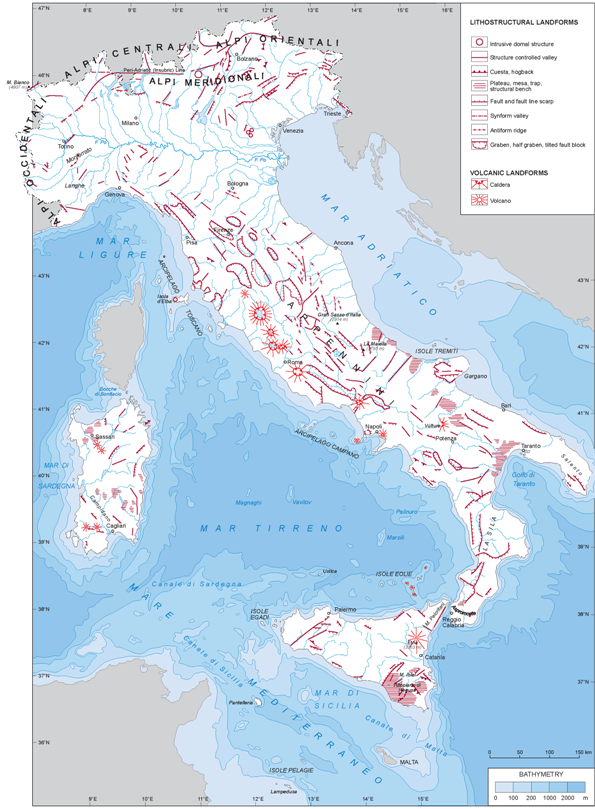
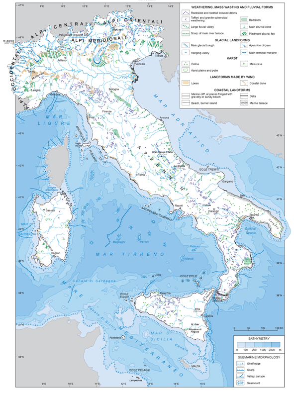
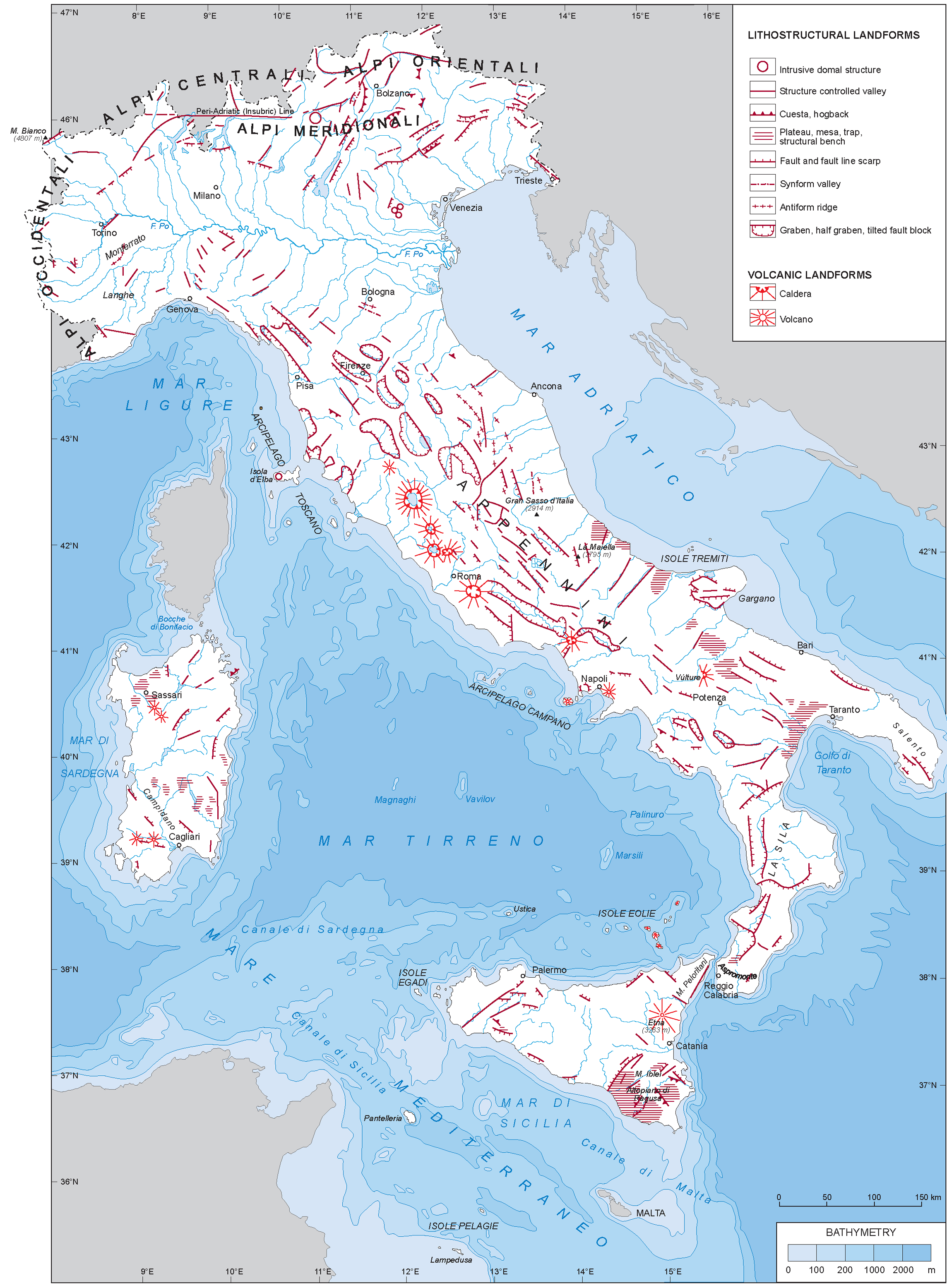
Morphologic description of the geomorphic units
The Alps
This mountain system forms a broad arc extending from the Ligurian coast and the French Riviera to Austria and Slovenia. The width of the belt is increasing eastward; where the chain sharply bends around Piedmont, the width is approximately 150 km. Only one main range occurs to the south of the Mont Blanc, while two broadly parallel ranges may be found eastward, divided by the Rhone-Rhine alignement. A remarkable feature is the asymmetry of the two watersheds, the southern being steeper than the northern. The difference is mostly due to the lithologic control of the ongoing erosion rates as shown for instance by Vernon et al. (2008).
In the Central Alps the morphology is more complex and the width of the chain is some 300 km. In this area and farther to the east the less deformed Southern Calcareous Alps are fringing to the south the Chain proper. The peri-Adriatic or Insubric line marks the limit.
The core of the Alps is formed of exhumed Hercynian basement rocks belonging to the European margin. Either side of the core, sedimentary rocks derived from Tetidean sediments widely outcrop. Because of the low erodibility of the basement rocks, all the highest peaks occur in the basement massifs.
The main drainage network is mostly longitudinal to the chain in the central sectors while on the Alpine margins most valleys show a centripetal trend. This is especially evident in the Southern Alps, where remnants of longitudinal valleys have been incorporated in the present southward trending drainage. Quite a few valleys appear misfit due to river captures operated by southbounding rivers activated by the uplift. Glacial scouring of the main Alpine valleys led to the buildup of extensive morainic arcs in the piedmont areas, where they fringe several large lakes.
The Po Valley
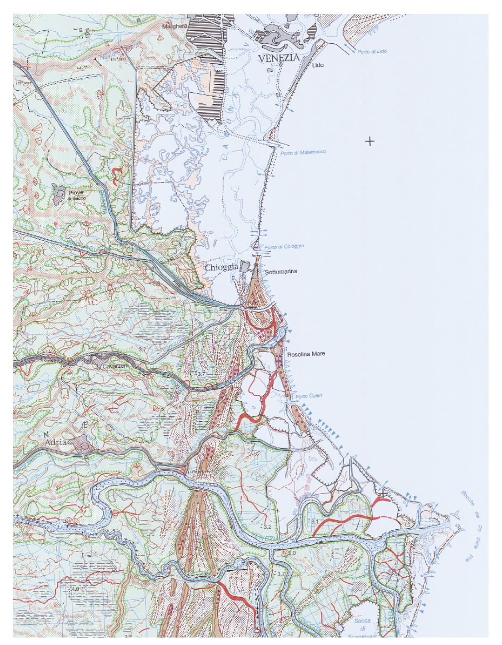
This is not actually a valley scoured by the Po river but a rather complex foredeep structure of both the Alpine and the Apenninic chains, filled by mostly marine Pliocene and Quaternary sediments and drained by the Po river. The location of the river in the valley is largely structurally controlled but also driven by the opposed thrust of the Alpine and Apenninic river sediments which make up the two facing piedmont plains. The Quaternary uplift of the Apenninic front in the western portion of the Plain resulted in the hilly Piedmont regions of Langhe and Monferrato. A Geomorphological map of the Po Plain at scale 1:250.000, a breakthrough in plains mapping, was published in 1997, Fig. 11 (MURST, 1997; see also Castiglioni et al., 1999).
Figure 11. Geomorphological map of the Po plain.
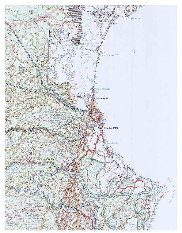
Part of the coastal belt, as represented in the Geomorphological map of the Po plain 1:250.000. (Copyright S.El.Ca., Firenze, 1997, reproduced with permission).
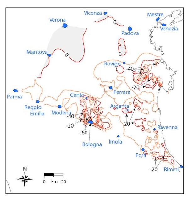
Holocene Po river terraces make up the southern, lower limit of the high plain on the Alpine piedmont. A line of springs occurs on the high plain, where ground waters percolating through the fluvio-glacial coarse deposits of the inner high plain are forced to emerge where the finer sediment of the outer high plain occurs. The central-eastern Po Plain is rapidly subsiding. Modern subsidence is at least an order of magnitude higher than due solely to long-term natural processes. This implies that most subsidence in the Po Plain has been induced by human activities (Carminati, Martinelli, 2002).
The Apennines
They make up the backbone of peninsular Italy, including Sicily. Due to their young, though complex tectonic history, they rather make up – from a morphostructural point of view - a mountain system rather a mountain range. From a geological standpoint, the Apennines and the adjoining seas can be regarded as an evolutive outcome of the eastward translation of the western portion of the Alpine chain. As a matter of fact, they are made of Hercynian basement rocks - largely outcropping in the Sardinia-Corsica massifs, in the Calabrian Aspromonte and in the Peloritani Mts. of Sicily, and locally elsewhere - by ubiquitous Tetidean Mesozoic – Early Tertiary units and by the flysches of Middle and Late Tertiary age. These units were lately overridden by slabs of Jurassic oceanic crust and by their associated sedimentary units.
The marked difference in geomorphological texture which affects the Tyrrhenian and Adriatic watersheds derive from a different tectonic and uplift history and thence from a marked difference of the outcropping lithologies.
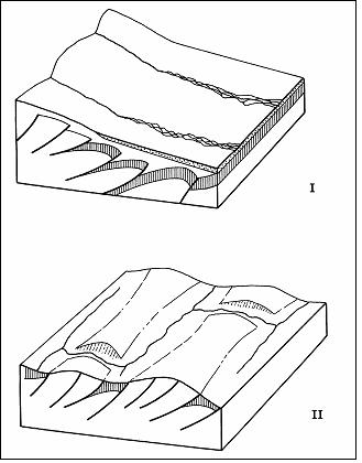
Because of the extensive outcrops of late Tertiary turbidites and postorogenic sediments, the Adriatic watershed from Piedmont to Puglia shows a striking morphological continuity, enhanced by a mostly consequent drainage pattern, which is being progressively replaced by a trellis geometry wherever the Mesozoic folded and faulted bedrock has been exhumed (Fig.13).
Figure 13. Sketch of the drainage evolution on the Adriatic watershed of the Apennines.

Consequent drainage being replaced through time by trellis on the Adriatic watershed, due to the swift rock uplift and the ongoing tectonic activity as well. Watergaps result from epigenesis and antecedence at the same time. Modified from Bartolini and Peccerillo (2002).
The generally eastward younging age of the rocks outcropping on this watershed applies also to the present day marine sedimentation occurring in the shallow Adriatic Sea, outer remnant of the Apennine peri-Adriatic Foredeep, which has been largely incorporated in the chain, less so in the Bradanic trough and the Gulf of Taranto.
The characteristic feature of the Tyrrhenian watershed is its basin- and range-morphology. The basins, presently bounded by normal faults, are actually often located in front of the NE verging Apenninic thrusts. The basins are typically offset from one another, as common in the extensional settings worldwide. The drainage pattern is closely controlled by the NNW trending tectonic structures.
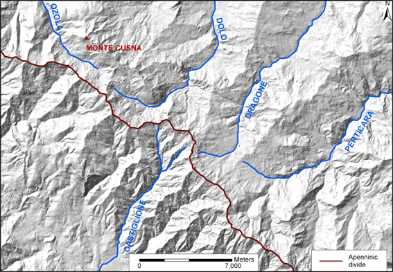
In the fringe of the Northern Apenninic divide, a few river segments trend along strike although in the progress of being beheaded by streams flowing at right angles (Fig. 14). The occurrence of such segments, until present unaffected by the orographic consequence of the ongoing uplift, points both to its recent age (Bartolini 2003, references therein, Bartolini et al., 2003) and to its fast pace (Balestrieri et al., 2003; Carminati et al, 1999; Zattin et al., 2002). Both differential uplift and lithology play a relevant role in driving a relentless reorganization of the drainage pattern.
Figure 14. River segments on the fringe of the Northern Apenninic divide.

In the Northern Apennine watershed area, Dolo, Dragone and Perticara headwaters stretched out until reaching a shale-marly weakness belt, there disrupting an along-strike river system located along the present Apenninic divide.
As to the Ligurian and the Northern Tyrrhenian Sea, they are the inner, drowned portions of the eastward translated Alpine chain. The farther translation of such chain in its southern segment gave rise to the partially oceanized Southern Tyrrhenian Basin, featuring large submarine volcanoes such as the Magnaghi, Vavilov and the still active Marsili, Palinuro and Eolian islands (see Fig.9). Magmatic activity took place, since Late Miocene times, also in the Northern Tyrrhenian area, both on land and at sea, as a consequence of the crustal thinning resulting from the eastward translation of the tectonic units which were piling up in the Apennine peri-Adriatic Foredeep.
The local relief of peninsular Italy is controlled by the present uplift rate but also by rock erodability. Because of their carbonate lithology and of the current uplift rate of approximately 1 mm/y, the Gran Sasso and Maiella massifs have a high relief (> 1800 m, see Fig. 3) and are the highest peaks of the Apennines as well.
The Puglia Plateau and the Gargano Promontory, located beyond the Bradanic trough, do not belong, from the geological standpoint, to the Apennine. They make up, instead, the emerged sector of the Southern Apennine Foreland.
The variety of landscapes which make peninsular Italy a fascinating place to visit and to live in is also due to the different geologic histories which affected each single portion of the region.
Sicily
The island may be considered as the East-West trending southerly extension of the Apennines. The Ragusa Plateau make up, here, the emerged sector of the Apennine Foreland, which contributes to the triangular shape of the Island.
A striking feature is obviously made up by the Etna Volcano. Its location, on thickened crust on the outer side of the chain, is not obvious; it is connected to a sinistral wrench fault responsible also for the shift affecting the Aspromonte versus Peloritani Mts. and of Sicily's insularity as well. The extinct volcano of Mt. Vulture, located on the inner fringe of the Bradanic Trough, has a similar – odd - structural setting.
Sardinia
This island is - along with its northerly sister, Corsica, and like the Aspromonte and Peloritani Mts. - a southeasterly translated portion of Hercynian basement rocks supporting, at places, relicts of their highly tectonized Alpine Mesozoic and Tertiary cover. Remnants of the Paleozoic planation surface carved in the Hercynian basement may be traced here and there (see, for instance, Bartolini, Peccerillo, 2002).
The Campidano Graben, filled with Pliocene and Quaternary sediments, is a large extensional feature pointing out that Sardinia shares, at present, the same structural setting of the whole Tyrrhenian area.