The shield
The Indian shield (Figure 1) is superficially bounded on the north by the Himalayan foothills but dipping underneath the Himalaya, it penetrates the underbelly of southern Tibet. It is comprised of 5 Archaean cratons and 3 fringing mobile belts (Ramkrishnan et al., 2008), and bears Proterozoic sedimentary basins, extensive flood basalts, rift valleys filled with coal bearing Gondwana sediments and Cretaceous marine incursions, as well as Tertiary and Quaternary sediments along the coasts, the Himalayan foothills and in river valleys. The shield is broadly divided into a northern block of the Aravalli-Bundelkhand cratons and a southern block of Dharwar-Bastar-Singhbhum cratons by the prominent WSW-ENE trending Central Indian Tectonic Zone (CITZ) which, stretching from the west coast at ~20ºN to ~24ºN in eastern India, is one of the three most striking mobile belts of the continent, also marked by the trans-continental Son-Narmada lineament.
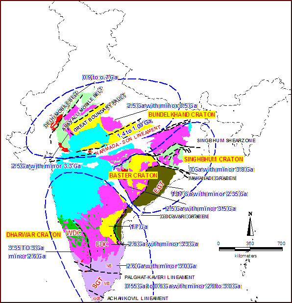
Figure 1. Typical ages of the 5 mapped cratonic elements of the Indian shield

Showing some typical ages of the 5 mapped cratonic elements of the Indian shield, the crescent shaped meso-Proterozoic Cuddappah basin in the eastern Dharwar craton and the fringing mobile belts (After Roger and Naqvi, 1987, Precambrian Geology of India, Oxford University Press)
The southern block cratons fringed by CITZ on the north, occupy a vast area of central, south and eastern India stretching south to ~10ºN and to the east coast passive margin where about its middle three quarters is overthrust by the fringing Eastern Ghat mobile Belt (EGMB). Two inter cratonic rifts of uncertain antiquity striking NW from the east coast, that were apparently reactivated during the Gondwana breakup and became sediment repositories of that age, separate the three cratons of the southern block concealing any deeper structural features that may connect them. On the west, an unknown expanse of the south-central Dharwar craton or a neighbour, is covered by the cretaceous flood basalts covering over 500,000km2 of the continental surface and perhaps twice as much of the adjoining sea floor, that spewed from the spreading ridge axis since shifted further westwards, presumably in conjunction with an underlying plume.
Geologically the best studied, Dharwar craton is a granite greenstone terrane that southwards passes into the higher grade Nilgiri-Madras granulites which apparently represent its lower crustal domain exposed to the surface by northward tilting or by thrusts. The craton whose structural grain is approximately NS is riven in the middle by a NS exposure of the Chitradurg schist belt bordering the narrow 400km long Closepet batholith to its east. The western craton has vestiges of early Archaean (3.3-3.4 Ma) enclaves but apparently suffered a most decisive tectonic event towards the end of that era. The eastern craton of the characteristic greenstones of gold affinity, is somewhat younger. The Nilgiri-Madras granulites which constitute the southern higher grade terranes of the Dharwar craton, are apparently sutured to the 550 Ma southern peninsular Pan African granulites and khondalites along the 10ºN, by the E-W striking high strain Noyil-Kaveri lineament of yet undetermined tectonic lineage. This is the third prominent mobile belt of the continent.
North of the CITZ, the shield is largely buried under the late Proterozoic Vindhyan sediments and beneath the Cenozoic foredeep along the Himalan arc. The Aravalli and the Budelkhand cratons of this block are separated tectonically by the SW-NE Great Boundary Fault, but superficially by the vast Vindhyan sediments stretching much farther east, that cover all but a limited exposure of the Bundelkhand craton thereby precluding from view the extent of its buried eastern expanse as well as the northern which may extend much farther north, even beneath the Himalaya. Indeed, the almost sudden appearance of the Himalayan fold and thrust belt above the foredeep in the north, and its remarkable syntaxial bends seem to require the buried existence of cratonic keels at the northwest and northeastern extremity of the northern block joined into an extensive along arc cratonic core which together determined the deformation boundary.
Geological investigations over the past half century have unraveled several important characteristics of the Indian shield Archaean cratons. Although, of these, only the Dharwar craton has been extensively studied, several broadly similar features are shared by them in varying degrees, highlighting the characteristic geodynamical processes that operated in the early era of the earth’s history, notably faster creation and motion of plates and basaltic slab melting in buoyant subduction to produce the ubiquitous Tonalite Trondjhemite Granodiorite (TTG) gneisses exposed in the cratons.
The five cratons of the shield (Figure 2), or at least its northern and southern blocks developed independently before being subsequently fused, mediated apparently by the subduction-collision process. The dominant rocks in the western Dharwar and Singhbhum cratons ahave been dated to be 3.0 Ga old with enclaves of 3.4 and 3.8 Ga respectively. The eastern Dharwar craton divided from the western by the Chitradurga schist belt as well as the Bastar, Bundelkhand and eastern Aravalli Mewar cratons have ages of 2.5 Ga with minor occurrences of 3.3 to 3.5 Ga rocks. All these cratons, to the extent that they have been investigated, are also dominantly comprised of the TTG gneisses which are believed to be the multiply processed products of primitive earth materials (Drummond and Defant, 1990)
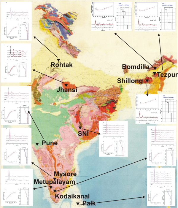
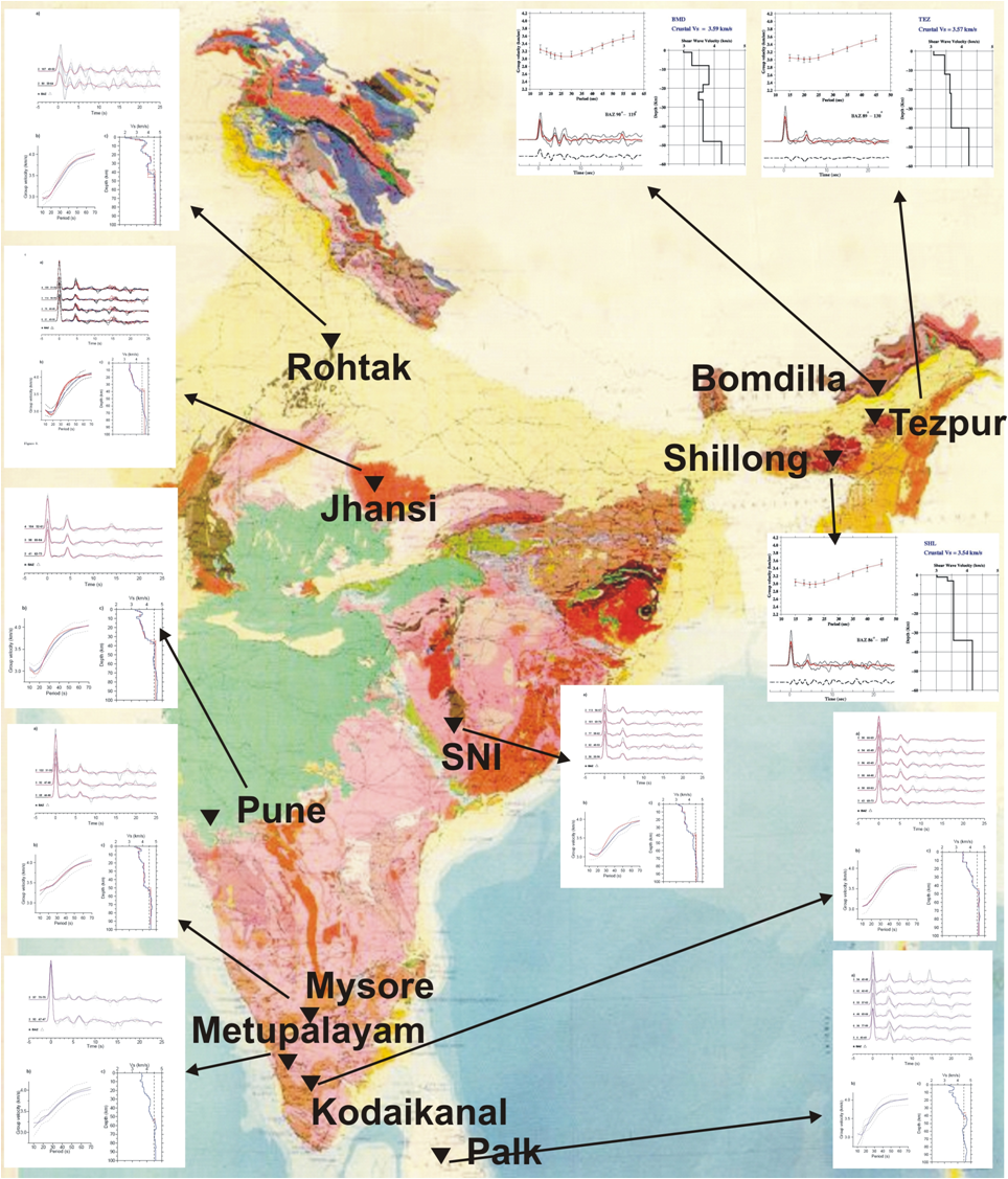
Figure 2. Crustal structure beneath selected sites
Shows the crustal structure beneath selected sites over the Indian continent, each marked by a triplet of sketches signifying the corresponding receiver functions (RF), surface wave dispersion curves(DC), and the inverted crustal structure on the right, distinguished by shear wave peeds with depth, obtained by minimizing the misfits with the measurement determined RF and DC (Charlotte Acton, 2009)