Introduction
Despite considerable advances in our overall understanding of the continental crust, uncertainties concerning the structure, composition and rheology of the deep crust remain unsettled, making it currently difficult to adequately address questions concerning the evolution of the exhumed mid- to lower crust high-grade granulite terranes. It is therefore felt that better constrained knowledge of their depth sections may provide clues to the nature of the lower continental crust and provide credible constrains on the overall composition of their crusts. Several such terranes of exhumed mid- to lower crustal rocks ranging from Archaean to Pan-African in age are found exposed in various parts of the world: Sri Lanka, Adirondacks (United States), Ivrea Zone (Italy), Kapuskasing (Canada), Namaqualand (South Africa), the Napier Complex (Antarctica) and Lofoten (Norway) (Heier, 1973). These high-grade terranes are ideal geological locations for modeling the structure and composition of the deep crust and for reconstructing past geodynamic and magmatic processes through exploration of their fossil imprints in the metamorphic, geochemical, seismic and tectonic characteristics of the crust (Rudnick and Fountain, 1995). The south Indian shield is an amalgamation of cratons and intervening mobile belts assembled between the Archaean and the Proterozoic, together with large tracts of high-grade granulitic terranes, believed to be of lower crust origin (Fig. 1). The shield is comprised of a variety of metamorphic rocks, covered at its margins by thin veneers of Phanerozoic sediments, and in the northwest by the extensive plume-related Deccan Volcanic (DVP) flood basalts erupted along the western rift margin at the end of Cretaceous. The metamorphic terranes range from the low-grade granite-greenstones (~3.4 Ga) of the Dharwar Craton that grade southward into the ~2.5 Ga high-grade granulites and charnockites and further south, across the Noyil-Kaveri boundary, to the Pan-African granulites, and the khondalites of meta-sedimentary origin (Naqvi and Rogers, 1987; Raith et al., 1997).
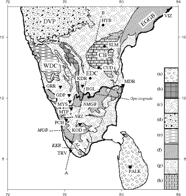
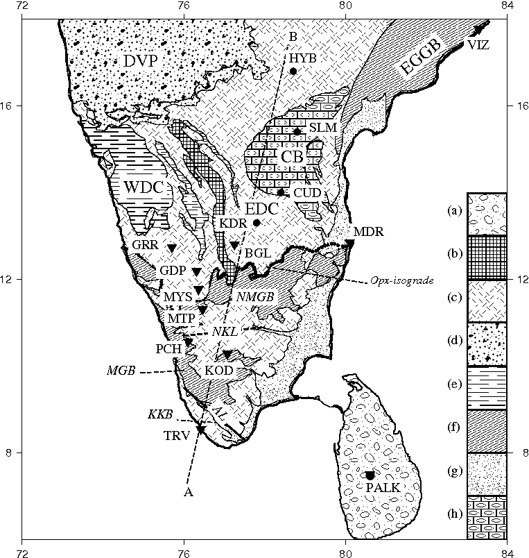
Figure 1. Simplified geological map of the south-Indian shield.
Location of seismic stations whose data were analyzed in this study is shown by inverted triangles; other stations are shown by circles. Important geological terrains include: (a) Sri Lanka granulite terrane, (b) Closepet granite, (c) Peninsular gneiss, (d) Deccan Volcanic Province (DVP), (e) Western Dharwar schists, (f) Granulites/Charnockites (g) Gondwana Sediments, (h) Proterozoic sediments of Cuddapah Basin (CB).(EDC and WDC: Eastern and Western Dharwar Cratons respectively; NMGB: Nilgiri Madras Granulite Belt; MGB: Madurai Granulite Belt; KKB: Kerala Khondalite Belt; AL: Achankovil lineament)
The eastern margin of the Dharwar Craton is fringed by a narrow belt of granulites that forms the eastern passive continental margin of the Indian Peninsula. Together, these high-grade terranes of the Indian shield, covering an area of ~40,000 km2, constitute one of the three largest Precambrian granulite provinces of the world, the other two being Ashuanipi of Canada (90,000 km2) and the wheat belt of Australia (60,000 km2) (Wilson, 1978, Gopalakrishna et al. 1986, Percival et al. 1992, Newton et al. 1998).
On the basis of their geochronological, petrological and mineralogical characteristics, Indian granulites have been grouped into four major blocks: the Nilgiri-Madras Granulite Belt (NMGB), the Eastern Ghat Granulite Belt (EGGB), the Madurai Granulite Belt (MGB), and the Kerala Khondalite Belt (KKB). The Nilgiri-Madras Granulite belt stretches southward of the lower grade Dharwar granite-gneiss terrane, from which it is separated by a diffused orthopyroxene isograde. The Nilgiri-Madras granulites are dissected by the well-mapped Moyar and Bhavani shear zones, and in the western sector they rise to elevations up to 2300m. forming the Nilgiri Hills. South of the Noyil-Kaveri boundary which in the west marks a remarkable gap in the continuity of elevated coastal tracts of the Western Ghats, lie the Madurai Granulite Belt (MGB) and the Kerala Khondalites Belt (KKB) which are divided by the NW-SE striking Achankovil lineament. Highland massifs of granulite/charnockite formations are major features of the Madurai belt as are the occurrences of sapphirine-bearing granulite lenses, indicating ultra-high-temperature metamorphism (Raith et al. 1997). The Eastern Ghat Granulite Belt (EGGB) forms the eastern coast of India. It has all the characteristics of a mobile belt: a linear feature stretching for over 900 km that suffered granulite-facies metamorphism throughout its length and breadth and a prolonged history of mountain building spanning most of the Proterozoic. All these high grade granulite terranes yield late Archaean-early Proterozoic ages for their protoliths and, except for the NMGB and KKB, were extensively reworked by the Neo-Proterozoic Pan-African thermal event (~650 Ma) which affected the then contiguous terranes of southern Gondwanaland from eastern Antarctica through Sri Lanka, southern India, and Madagascar to the Mozambique belt of east Africa and as far north as Arabia.
Because of their intriguing tectonic setting, the two major terranes of the Indian shield, the low grade Archaean Dharwars and the adjoining granulites have been the focus of several scientific investigations. Crustal characteristics of the various segments of the Archean Dharwar Craton have been rather well constrained from receiver functions analysis (Gaur and Priestley, 1997, Rai et al. 2003, Sarkar et al. 2003, Rai et al. 2008), and deep seismic sounding studies (Sarkar et al. 2001). These investigations reveal a homogeneous, almost seismically transparent ~35 km thick crust beneath the eastern Dharwar Craton, but a thicker, more complex crust beneath the western Dharwar Craton. Recently a number of geophysical studies have been made over a 200 km long N-S profile in the northern part of the southern granulite terrain. These include reflection seismology (Rao et al. 2006, Prasad et al. 2006), gravity (Singh et al. 2006) and magneto-telluric (Harinarayana et al. 2003). These studies reveal thickening of the crust to ~44 km as well as presence of significant features in the deep crust. However, these investigations do not provide any constraint on the details of the subsurface seismic velocity structures of the granulite crust. Models of their genesis and petrology, therefore, still remain largely conjectural. This paper presents a detailed study of the seismic characteristics (crustal thickness, shear-wave structure, and Vp/Vs value) of the south Indian granulite crusts and compares these results with those of the Archean Dharwar Craton to elucidate possible mechanisms that lead to granulitization, and have sustained the long-standing stability of these granulite terranes through Phanerozoic tectonism.