Geological setting
The Bengal Basin is bordered by Precambrian Chotanagpur gneissic terrain in the west and northwest (Dasgupta et al., 2000; Dasgupta and Mukherjee, 2006) (Fig. 1). Bengal basin margin fault in the west demarcates the Chotanagpur terrain in the west and a sequence of early Permian to early Triassic coal bearing Gondwana rocks, Jurassic Dubrajpur Formation and Cretaceous Rajmahal flood basalt in the east (Fig. 1). This fault, named as Sainthia-Brahmani Fault (SBF) (Dasgupta et al., 2000) developed following the western and northwestern margin of the Bengal Basin. SBF and other faults further east of SBF (Fig. 1) (e.g. Rajmahal Fault, Dasgupta et al., 2000) are genetically related to the extensional tectonics prevalent over this region during the early Cretaceous period and may have been related to the Rajmahal effusion linked with India’s passage over the Kerguelen and Crozet Hot-Spots presently located in the Indian Ocean (Nandy, 2001; Dasgupta and Mukherjee, 2006). The age of SBF is not certain but definitely it was active till post-Jurassic time since it has affected the Jurassic Dubrajpur Sandstone. Fault rocks are well exposed along the SBF of the study area (Fig. 1) and are typically represented by strongly fractured and hydrothermally altered cataclastic rocks encompassing ‘layers’ of silicified fault breccia or fault gouge (terminology after Sibson, 1977).
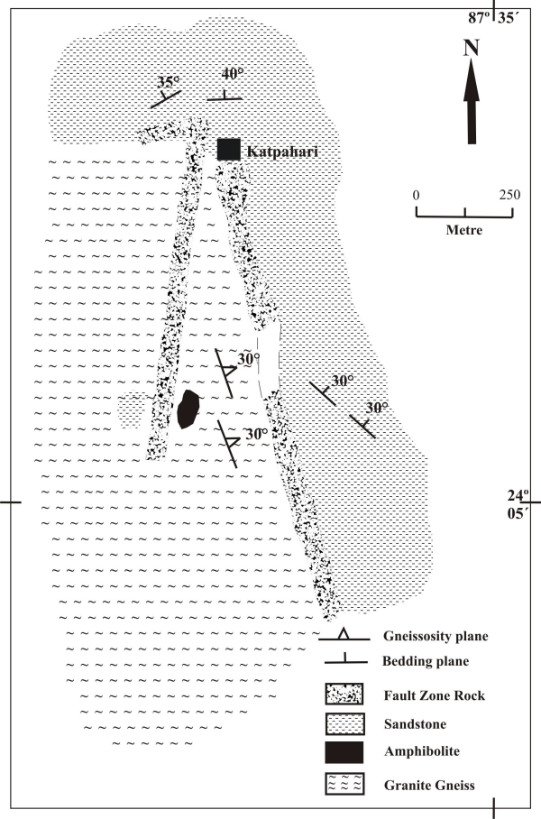
The area of study is underlain by the rocks of Chotanagpur granite gneiss with enclaves of amphibolite partly covered by Dubrajpur Sandstone. There are three ‘bands’ of fault rocks – two of which have N-S trends exposed over a length of ~1 - 1.5km, and the third one has a E-W trend exposed over a length of ~250m (Fig. 2). Maximum thickness of the fault rocks goes up to ~20 meters. In Chotanagpur granite gneiss foliation is pervasively present with more or less uniform orientation, while in cover sediments bedding shows variable orientation (Fig. 2).