Introduction
The Proterozoic era representing about half of the record earth history ranging in age from 2500 to ~550 Ma (Pharaoh et al., 1987), is of great significance in understanding the evolution of Earth’s crust. This period is characterized by the development of stable cratons which behaved as internally rigid crustal units similar to modern lithospheric plates (Windley, 1982). Recent data on composition of volcanic rocks, sedimentary facies, and structural trends and ore association suggest that different components of Proterozoic crust were formed in different tectonic settings, although the identification of such tectonic setting is still an enigma. The highly variable composition of early Proterozoic crust suggests a drastic change in the growth of the continental crust at the dusk of Archaean period (Naqvi, 1981; Taylor and McLennan, 1985; Pharaoh et al., 1987).
The occurrence of Archaean type lithological units along with practically unique and new lithological elements in the early Proterozoic crust assemblages suggests that the Archaean-Proterozoic boundary represents a transitional period (Cloud, 1976; Taylor, 1987). This boundary is characterized by diachronous successive stabilization of cratons and considered as one of the major crust forming events in the earlier history of the earth (Moorbath, 1977; McCulloch and Wasserburg, 1978; Taylor, 1987). It is believed that towards the end of the Archaean, the major changes in global tectonic were related to cooling (Bickle, 1990, Ahmad and Rajamani, 1991) which is evident from the relatively less abundant occurrences of komatiites and related rocks in early Proterozoic terrains. The large volume of komatiites in Archaean terrains indicate presence of higher temperature and extents of partial melting prevailing during that period, giving rise to mantle plume related magmatism during the Archaean (White and McKenzie, 1989; Bickle, 1990; Campbell and Griffiths, 1990), and changing patterns of convection system (Hargraves, 1981; Bickle, 1990).
The possible role of plate tectonics during Proterozoic has received much attention by the geologists (Kroner, 1981; Schweitzer and Kroner, 1985; Condie, 1986 and 1989) and it is now widely accepted that the Precambrian plate tectonic process was similar to those operating today. The only differences may be in the size of plates (Tarney and Windley, 1977). Since certain characteristics of mafic magmatic rocks are considered to be related to their tectonic settings, geochemical studies of these rocks can give clues about petrogenetic processes and tectonic settings at the time of their emplacement. Therefore, the geochemical characteristics of mafic magmatic sequences coupled with geochronological and other field controls can provide better constraints to evaluate the evolution of mantle through time, possible mantle heterogeneities and petrogenetic processes (Condie, 1985 and 1989).
Geological setting of the study area
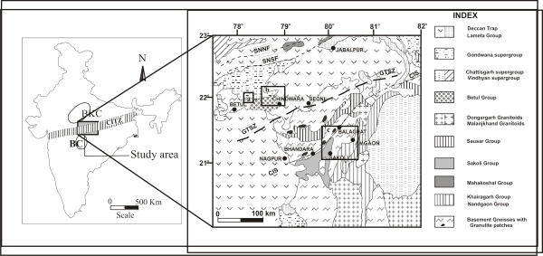
The Central Indian Tectonic Zone (CITZ) is an important, continental scale tectonic zone of Proterozoic age. It divides Indian continental shield into two tectono-magmatic provinces, the northern crustal province comprising Bundelkhand craton and the southern peninsular crustal province comprising Bastar, Dharwar and eastern Singhbhum craton (Stein et al., 2004; Acharyya and Roy, 2000). CITZ is over 1600km. long with width up to 200km (Stein et al., 2004), and is bounded by lineaments called Son-Narmada North Fault (SNNF) in the north and Central Indian Shear (CIS) in the south (Fig. 1a). In between these extreme boundaries two more lineaments have been identified as Son-Narmada South fault (SNSF) and Gavilgarh-Tan Shear Zone (GTSZ) (Yedekar et al., 1990; Jain et al., 1991). The rocks exposed in the study area comprise Amgaon Gneissic Complex (AGC), Tirodi Gneissic Complex (TGC) of ~2500-2200 Ma old and Betul supra crustal sequences. Whole rock Sm-Nd isochron age for the acidic volcanic rocks of Sakoli bimodal volcanic, south of the CIS, has given the age of crystallization at ca. 1675±180 Ma (Ahmad et al. 2009).
The Betul-Chindwara belt forms a conspicuous lithotectonic unit composed of volcano-sedimentary succession intruded by mafic-ultramafic and granitic suite of rocks. Amgaon and Tirodi Gneissic Complex have mafic magmatic rocks in the form of volcanic flows, amphibolites and doleritic dykes of distinct entities. Most of these dykes are probably of Paleo-Mesoproterozoic age, as they do not traverse through the overlying younger stratigraphic sequence. We have studied the mafic dykes and flows from distinct lithological packages, covering large area to understand their nature, evolutionary trends in terms of petrography, geochemical characteristics and their petrogenesis. These in turn will help us understand the nature of the Precambrian sub-continental mantle source that gave rise to the volcanics and dykes in the CITZ and its immediate south across the CIS (Fig.1).
Figure 1. Outline Geological Map of the Indian Shield (inset) and the Central Indian Shield
Map Showing the regional geology of the study area along with the disposition of major lineaments and Super-groups along the Central Indian Suture (modified after Roy and Ramachandra, 2003) Inset map of India showing outline of the Central Indian Tectonic Zone.
The Betul belt is overlain by Gondwana sediments and Deccan Trap on all three sides, but for a narrow corridor near Kanhan River through which it is connected to the CITZ basement. TGC, volcano-sedimentary sequence, younger metasediments, acid and basic intrusive of Archaean to Neo Proterozoic age occupies the north-eastern and northern part of the study area. Amla Gneiss of the TGC is the oldest litho-unit, exposed ~16km southwest of Betul town. The rocks range in age from Mesoproterozoic to Quaternary, the basaltic lava flows of Deccan traps are well exposed in the eastern and southern part. Numerous E-W trending dykes and sills mostly of mafic composition are exposed. They range in length from a few hundred meters to several kilometers, width ranging from a few meters to a few hundred meters. TGC includes the migmatites and basement gneiss/older migmatite (Fig. 1b). The migmatite comprise at least two phases of migmatization of which one involving partial migmatization of Sausar sediments has been dated to be about 1525±70 Ma (Sarkar et al. 1986). The AGC includes the migmatite/gneiss exposed south of the CIS, characterised by numerous amphibolites, dolerite, basic and ultrabasic intrusive. Like the TGC, the AGC also exhibits multiple mafic magmatic episodes (Fig. 1c).
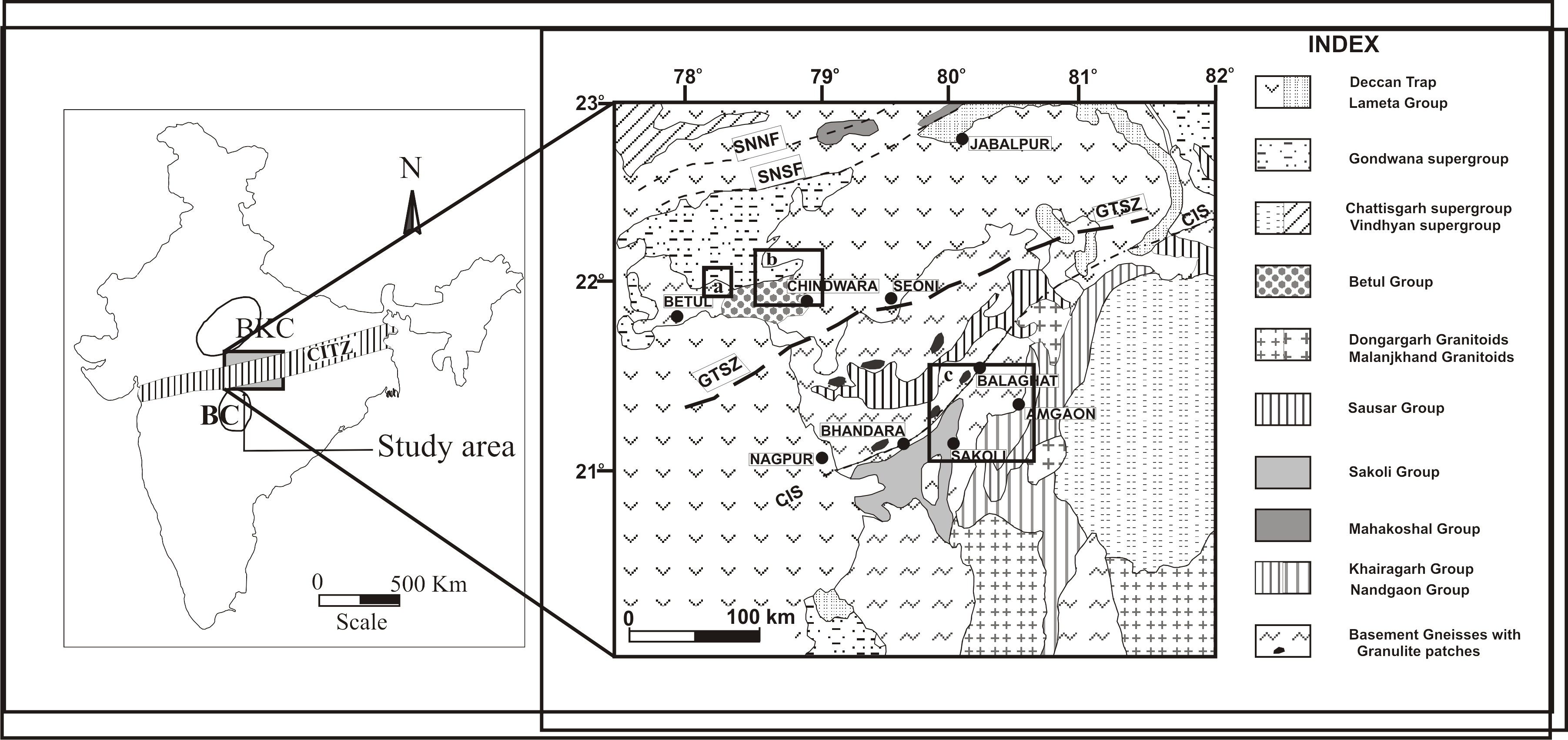
Figure 1a. Geological map around Betul area

Geological map of Betul area with sample location. Map modified after district resource map (Geology and Minerals)-Betul district, M.P, Geological Survey of India (Central region).
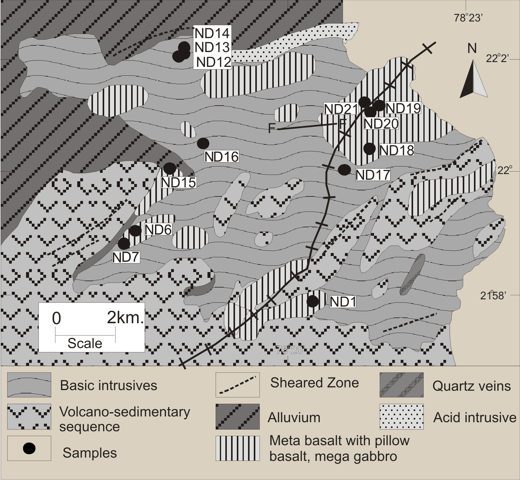
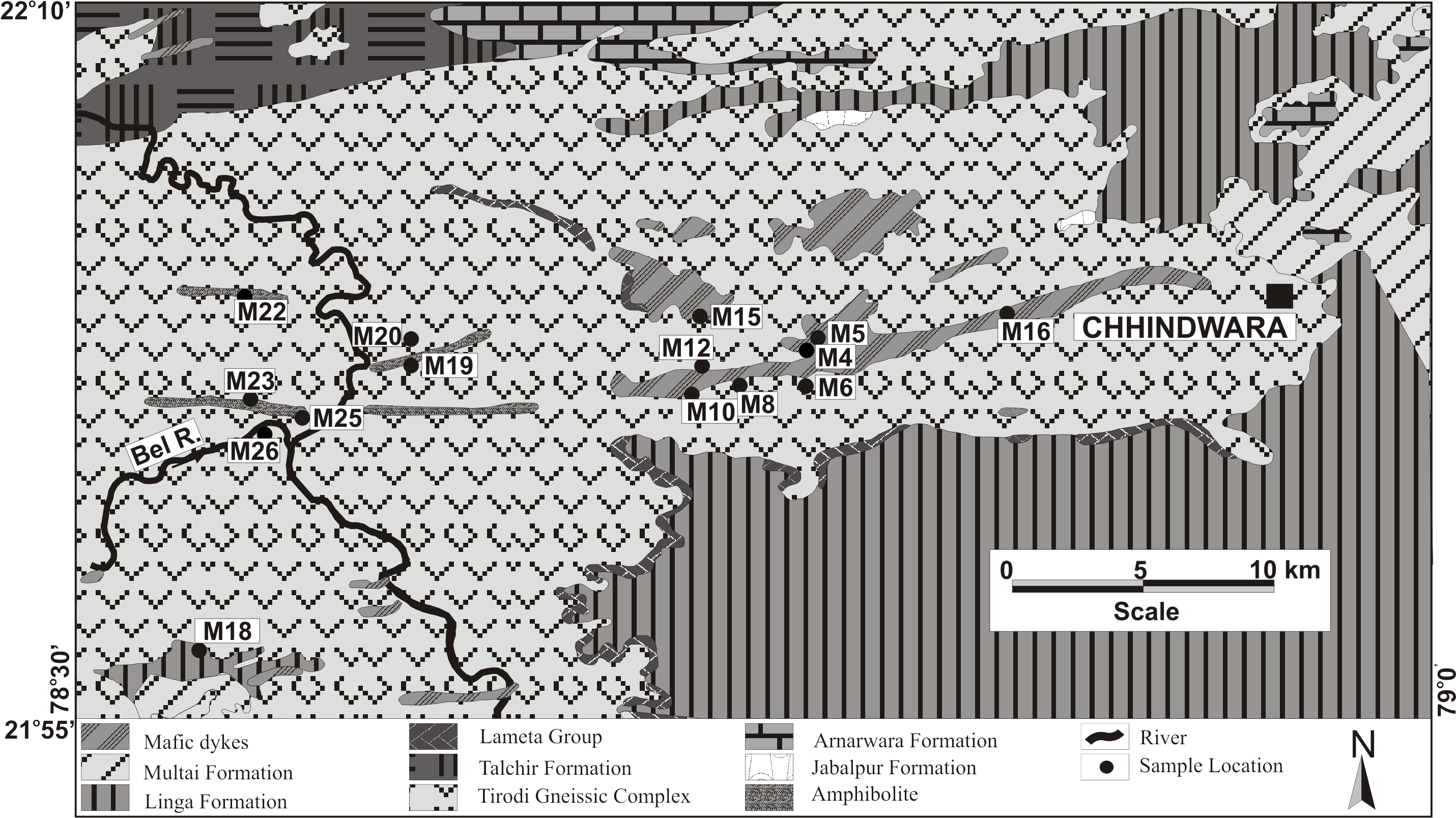
Figure 1b. Geological map around Chindwara area
Geological map showing location of the mafic magmatic dyke from Tirodi Gneissic Complex (TGC) around Chhindwara region. (Modified after District Resource Map, GSI).
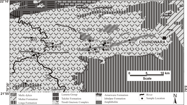
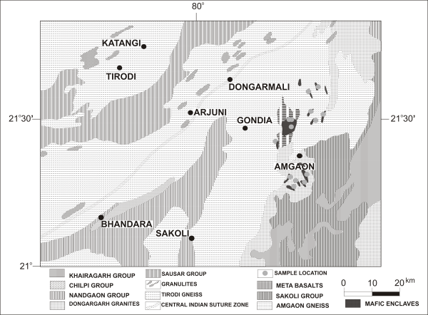
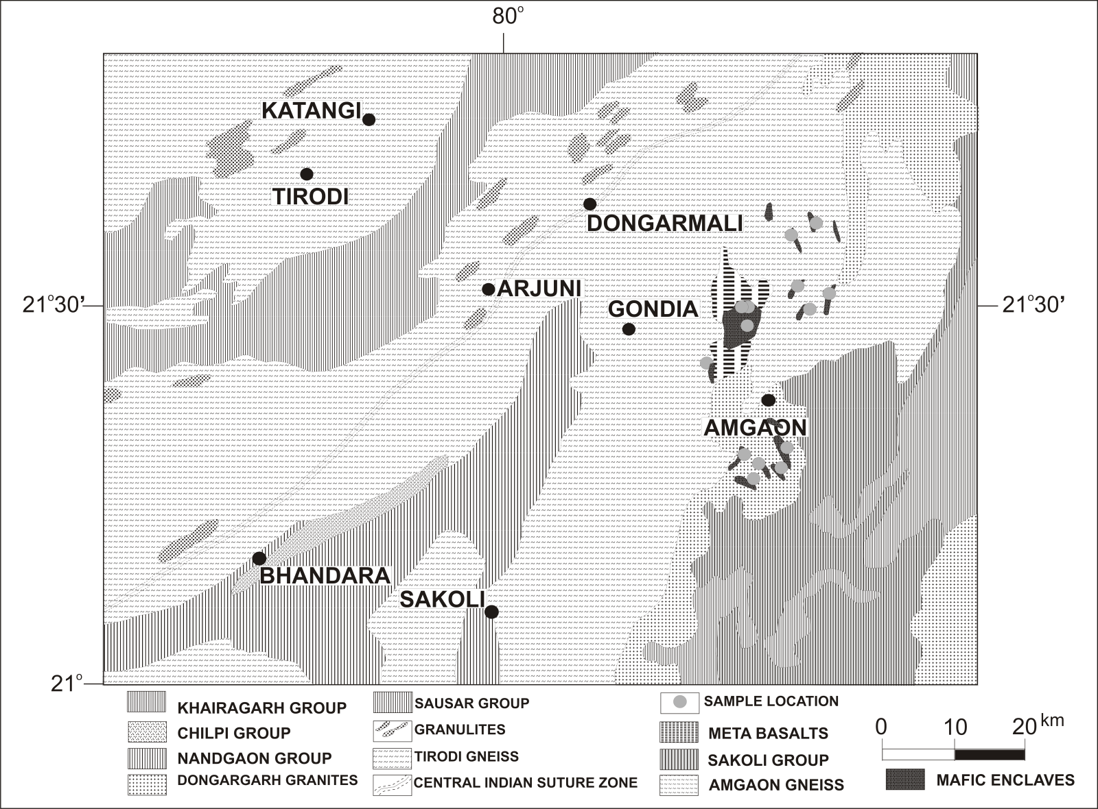
Figure 1c. Geological map around Amgaon area
Geological map Amgaon area showing the mafic magmatic bodies and sample locations in the Amgaon Gneissic Complex (AGC) (modified after Yedekar et al., 2003).
Petrographic character
The doleritic rocks show ophitic to sub ophitic texture. Characteristically leached iron stains are present along the opaque minerals. The samples of amphibolites show a holocrystalline rocks with subhedral to euhedral plagioclase (sodic and calcic) grains and Fe-oxides are present as essential phase while quartz and pyroxenes are present as accessory minerals. Some samples show normal lamellar twins that may have developed due to the cubic-tetragonal transition of the mineral, while some samples show the intergrowth of the plagioclases crystals. The leaching of the Fe-oxide grains is very prominent that shows the second phase of paragenesis. Some plagioclase grains show sericitization.
In the amphibolites samples hornblende, plagioclase, clinopyroxene and Fe-oxides are present as essential minerals; quartz and mica (biotite) grains are present as accessory minerals. Schistosity is well developed; thin sections show ophitic to subophitic texture. Albitization of pyroxene grains is very prominent in some sections. In a majority of the thin sections two phases of mineral formation are observed, one phase has palagonite formation and the other represents leaching of Fe-oxides. The plagioclases are of two generations. One that is older shows more calcic phases and the later one more sodic nature which probably indicates the sodic metasomatism of the sample or enrichment of sodium from the outer sources.
The samples of Betul mafic volcanic rocks show an inequigranular, subhedral to euhedral, holo-crystalline to hypo-crystalline texture. These rocks have plagioclase (sodic and calcic), pyroxene and Fe-oxide as essential minerals while quartz and plagioclase in ground mass are present as accessory minerals. Ground mass is granular composed of plagioclase, quartz and volcanic glass. The palagonite (characteristically) is the alteration product of basaltic glass, which probably formed by hydration and devitrification process. Dissolution contacts around the palagonite grains are prominent in some samples.